
KING’S HIGHWAY
Of Jordan’s three highways (only one of which is a dual carriageway) running from north to south, the King’s Highway is by far the most interesting and picturesque, with a host of attractions lying on the road or nearby. The highway connects the mosaic town of Madaba to the pink city of Petra via Crusader castles, Roman forts, biblical sites, a windswept Nabataean temple and some epic landscapes – including the majestic Wadi Mujib and a gem of a nature reserve at Dana.
Kasr Bshir. Finding this Roman castellum is not easy; even when you have with you somebody who has been there before. On the Desert Highway, one small track off to the west looks much like any other: a small square block squatting on a flat piece of chert desert. Untouched by the hand of modern man, it is square with a three-storey tower at each corner, and a single gateway.
Sanctuary of Agios Lot is SE of the Dead Sea overlooking the modern town of Safi. It is a Byzantine era (5th – 7th Centuries AD) monastic site that consists of a basilical church erected at the entrance to a natural cave. The spot of construction was thought to have been where Lot sought shelter after Sodom was destroyed. Inscriptions on Byzantine mosaics in the sanctuary date to the 7th century, but other archaeological finds in the cave indicate a sizable Early Bronze Age and Middle Bronze Age presence. This site was added to the UNESCO World Heritage Tentative List in 2001 in the Cultural category.
KARAK (pop 28,000).
Crusader Castle. One of a long line of castles built by the Crusaders stretching from Aqaba in the south to Turkey in the north, they are the sites of the 12th-century battles between the Crusaders and the Muslim armies of Saladin. At one point, the castle belonged to Renaud de Chatillon, an unsavoury and treacherous knight of the cross, who was renowned for his sadistic delight in torturing prisoners and throwing them off the walls into the valley 450m below; he even went to the trouble of having a wooden box fastened over their heads so they wouldn’t lose consciousness before hitting the ground.
The castle has an Ottoman Gate, Crusader Gallery (stables), soldier’s barracks and kitchen, church, Mamluk keep and palace (built in 1311 using earlier Crusader materials), and an underground marketplace.

I don’t think I have had so much taxi and driver abuse in my life. I have lost faith in some Jordanians. I never did figure out if I could catch a service taxi from Shobsogh to the South Bus Station, but I could from the North Bus Station and after a couple of taxis got to the North. Nobody spoke English. Then I was told it was 1JD and after a very long drive across Amman, I was only charged 500 fils. I gave him 1 JD. Then it was 2 hours to Karak and 2 buses across Karak to get 2 blocks from Karak Castle, high on the hill above town.
The castle has stupendous views to the west and south and east back to Karak but is in itself possibly not worth the hassles of getting there. There are many big barrel-vaulted rooms and passageways.
I walked down to a bus station and after a bus to some town, it was a walk and a second bus to a third bus heading to Tafila, a transportation hub. Here the whole tenor of the people changed – to very nice. I had great help from two guys and was finally on my way to Qadsiyya, the town 1km below the turnoff to Dana and the Dana Biosphere Reserve.
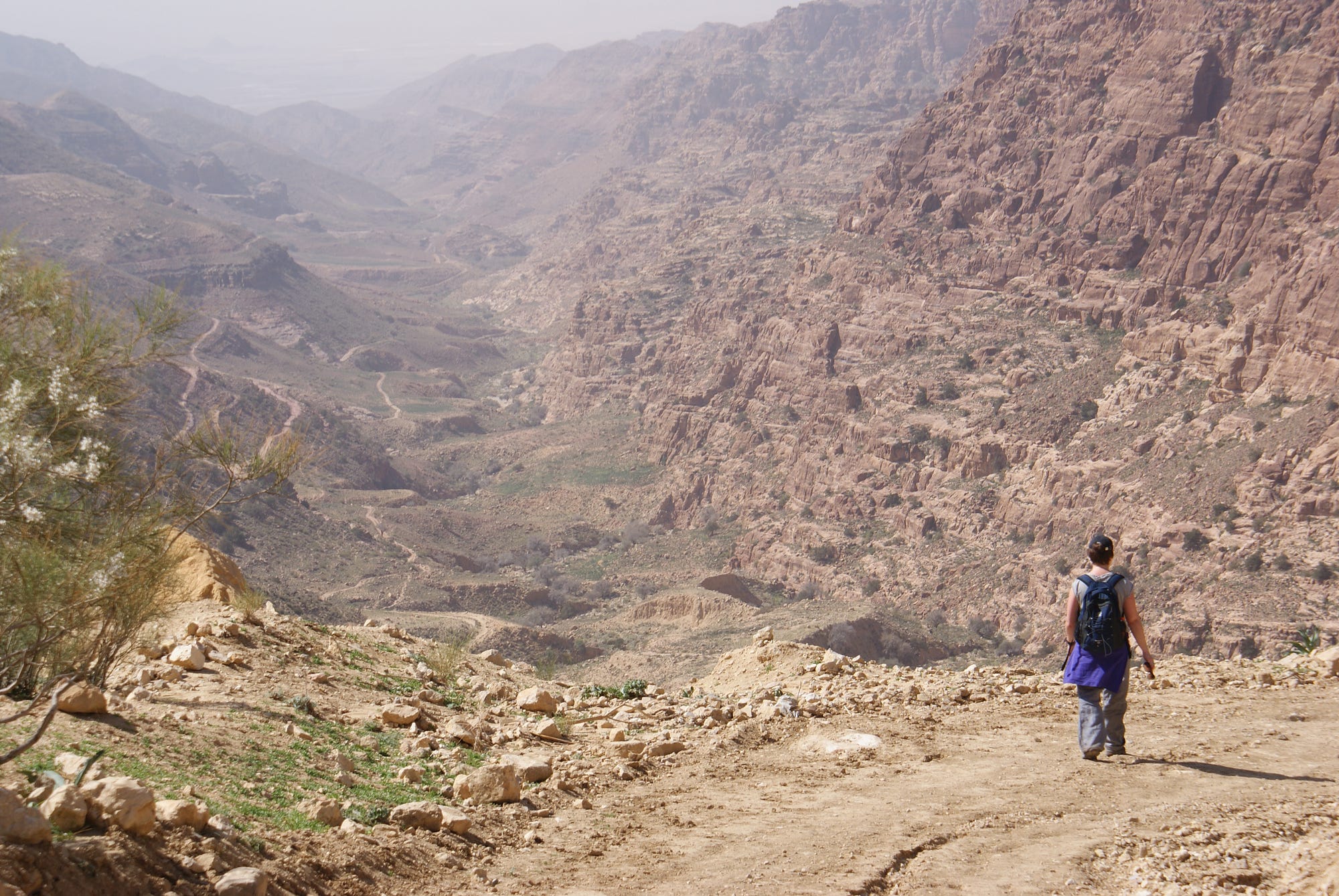
DANA BIOSPHERE RESERVE
This is one of Jordan’s hidden gems and its most impressive ecotourism project. The gateway to the reserve is the charming 15th-century stone village of Dana, which clings to a precipice overlooking the valley and commands exceptional views. It’s a great place to spend a few days hiking and relaxing. Most of the reserve is accessible only on foot.
The reserve is the largest in Jordan and includes a variety of terrain – from sandstone cliffs over 1500m high near Dana to a low point of 50m below sea level in Wadi Araba. Sheltered within the red-rock escarpments are protected valleys that are home to a surprisingly diverse ecosystem. About 600 species of plants (ranging from citrus trees and juniper, to desert acacias and date palms), 180 species of birds, and over 45 species of mammals (of which 25 are endangered) – including ibexes, mountain gazelles, sand cats, red foxes and wolves– thrive in the reserve.
Dana is also home to almost 100 archaeological sites, including the 6000-year-old copper mines of Khirbet Feynan.
The visitor centre in the Dana Guest House complex includes a museum, craft shop, nature exhibits and a food-drying centre for making organic food.
Most trails require a guide with a cost depending on time and number of people. One route is the unguided Wadi Dana Trail, a 14km trail that switchbacks steeply down into the gorge to Feynan Lodge (a vehicle back costs 45JD). This is the first day of most treks on the 3-5 day “back door to Petra”.
Getting There. Minibuses run every hour between Tafila and Qadsiyya with the turn-off to Dana village 1km north of Qadsiyya. Get dropped off at the crossroads and walk or hitchhike down the 2.8 km to the village.
I emailed Dana Tower Hotel (15JD including breakfast and dinner) to stay 2 nights.
I was let off at the top of the road in full cloud – white-out conditions, windy and cold. I put on my gloves and warm clothes and started the walk down the road, hoping to hitchhike. No more than a minute passed and I was picked up by a guy who worked at Dana Moon Hotel. The manager asked how much I wanted to pay (I hate that question). I didn’t respond and he offered 4JD!! for a single room with a king-sized bed. It was unheated but that would be my preference anyway. Mohammed, the manager speaks great English and is very hospitable.
I walked down through the tiny town and stopped at Dana Towers Hotel. There were 5 travellers there and I sat around and gabbed for a couple of hours in the heated lounge. When their dinner arrived (a sumptuous banquet), I returned to my hotel for dinner in their restaurant next to a heater.
The next day (February 11) dawned with clear blue skies. The view from the “edge” looked straight down the entire wadi and past over a huge plain. Then everything disappeared into the smog-like haze.
The owner of Dana Towers complained about Mohammed stealing his guests and I decided to change hotels. Even though the room was cheap, Mohammed inflated the prices on everything else and the total bill came to 17.5JD. The bed and room were much nicer at the Moon but the Towers were better in other ways – a heated “lounge”, wi-fi and more tourists. I was also getting tired of every sentence ending with “my friend”. Four of the guests were 2 French couples and the other was a German woman here installing a 38-tower wind farm high above Dana. They all left the next day to be replaced by a French family of 4 travelling for 7 days around Jordan with their guide. I sat around all day reading and relaxing.
I got a free ride up the hill with the hotel into Qadsiyya (normally there is a bus at 8 am but today was Friday). I walked through town refusing more than one ride for too much money but finally bargained for a 4JD ride to Shobak. For another 1JD, he drove me the 3km out of town to Shobak Castle (free).
SHOBAK. Perched in a wild, remote landscape, Shobak Castle is less complete than Karak and there is almost no view. Formerly called Mons Realis (Mont Real, or Montreal – the Royal Mountain), it was built by the Crusader king Baldwin I in AD 1115. It withstood numerous attacks from the armies of Saladin before succumbing in 1189 (a year after Karak), after an 18-month siege. This was the last time the Trans-Jordan had any historical significance – as an administrative and military role. Shobak was part of the Crusader defence system of the Outer Jordan (Aqaba, Petra, Showbak, Tafileh, Karak and Ahamant or Amman). Excavation has revealed a market, two Crusader churches and a semicircular keep whose exterior is adorned with Quranic inscriptions, possibly dating from the time of Saladin.
The real highlight is the underground escape tunnel that winds down seemingly forever into the bowels of the earth,. It starts off with good steps that quickly degrade into sloping steps into a slippery slope, but handholds are good (there are 365 steps but at least 300 are no longer functioning). The ceiling is high so there’s no need to crouch. The tunnel ends at a chimney with steel rungs finally resurfacing beside the road. Bring a torch and confidence that it does end.

I hitchhiked back to Shobak, the town, through town and finally paid 5JD (everyone wanted 10 or 15 or 20) for a ride to within 30m of my hotel in Wadi Musa – Saba’a Hotel.
WADI MUSA (pop 20,000)
The village that has sprung up around Petra is Wadi Musa (Moses’ Valley) – a string of hotels, restaurants and shops stretching about 5km from Ain Musa, the head of the valley, down to the entrance to Petra. The village centre is at Shaheed roundabout, with shops, restaurants and budget hotels, while midrange hotels are strung out along the main road for the remaining 2km towards the entrance to Petra.
Accommodation. The price increases as you get closer to Petra. Stay in Central or Upper Wadi Musa for the cheapest places. Saba’a Hotel (dorm 8JD), just north of the circle, is owned by an English woman and her Jordanian husband. Very nice to deal with a Westerner for once. She said that since 2006, tourism in Petra is down 80% and 2015 was their worst year ever. She knows of 11 hotels in Wadi Musa that have closed.
Cave Bar. Occupying a 2000-year-old Nabataean rock tomb next to the Petra Guest House, this is arguably the oldest bar in the world.
PETRA
History. There is evidence of habitation 70,000 years ago, houses from the Neolithic period (8500-550BC), Bronze Age (3700-1200BC), Iron Age (the Edomites 1200-539BC), Babylonians (5th century BC) and then the first arrival of the Nabataeans in the 6th century BC. The spectacular sandstone city of Petra was built in the 3rd century BC by the Nabataeans, nomadic Arabs from NW Saudi Arabia, who controlled the frankincense trade routes of the region in pre-Roman times. They carved palaces, temples, tombs, storerooms and stables from the sandstone cliffs. From here, they commanded the trade routes from Damascus to Arabia, and great spice, silk and slave caravans passed through, paying taxes and protection money. Petra was at the centre of several trade routes: Egypt to the west, NW by the Mediterranean to Europe, north to the Levant and the Spice route from the east. Frankincense and myrrh (used as incense burned at temples, in burials, for embalming, sacrifices and rituals, it was incredibly expensive at the time, but wealthy Romans were willing to pay) were produced in present-day Oman and Yemen (in 100 BC the Minaen Kingdom in Yemen collapsed and the Nabataeans took over), transported via 65 camel stages over 12 weeks to Petra and onto Gaza, a distance of 2750kms. They were able to control rainwater by building 5 major aqueducts, cisterns and reservoirs, and using clay pipes and waterproof cement. In a short time, the Nabataeans made great advances – they mastered hydraulic engineering, intense agriculture, textile production, iron production, copper and silver refining, glass production, wine production (there were 40 rock-cut wine presses in the Petra area), sculpture and stone carving. There were 11 Nabataean kings until the last one died in 106 AD. They borrowed architectural ideas from Assyrians, Syrians (arches), Egyptians (obelisks), and Greco-Romans (pediments, capitals, triglyphs, and metopes), all identifiable in the rock-cut structures. The structures were started at the top and worked down using metal chisels and then covered all the rock with a thin layer of plaster, now mostly gone. The surfaces, corners, and roofs are perfectly done, absolutely flat and covered in fine chisel work. Their kingdom at its height supported 20,000 people and all the caravans and spread from Damascus to NW Saudi Arabia, the Sinai and well past eastern Jordan.
The Romans occupied the area for 2 centuries followed by the Byzantines (324, converted the Monastery and Urn tombs into churches). An earthquake in 363 destroyed much of the water system aqueducts and crumbled the free-standing structures of the Qasr al Bint and the Great Temple and after a second one 551, the Byzantines moved to Karak. The Umayyads in the 7th century used it as a pilgrimage stop between Damascus and Mecca. The Abbasid Caliphate moved their capital to Baghdad in the 8th century. Crusaders built 3 fortresses here in the 11th century to obstruct pilgrimage routes but were eventually overcome by Saladdin.
It was rediscovered by accident in 1812 by the Swiss explorer, Johan Burckhardt (the same chap who stumbled on the temple at Abu Simbel in Egypt). Until his momentous journey, disguised as an Arab, the neglected city, hidden deep in the rocky valleys of Wadi Musa, had escaped the attention of the Western world for hundreds of years. British explorers came in 1818, French artists in 1827 (the first to find the Monastery), the first American, John Steens in 1832, and the first woman, Charlotte Rowley in 1835. It was a star attraction in the 1989 Indian Jones movie, the Lost Crusade.
A guide costs 50-70 JD (but all info is easily found in the museum and by reading). Avoid the horse ride after the entrance (it is free and included in the ticket, but you will be forced to pay a healthy tip). And be prepared for constant hassles from touts for donkey and camel rides and the many Bedouins selling trinkets throughout the site.
You approach Petra through the legendary 1.2 km-long, high-sided Wadi Siq.

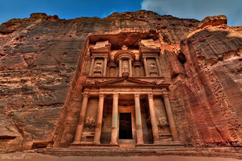
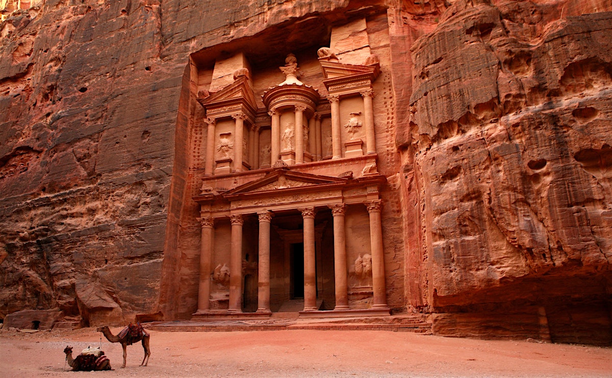
This is not a canyon, but rather a rock landmass that has been rented apart by tectonic forces. Just as you start to think there’s no end to the Siq, you catch breathtaking glimpses ahead of the most impressive of Petra’s sights, the Treasury, known locally as Al-Khazneh. 39.5m high, it was carved out of iron-laden sandstone to serve as a tomb to King Aretas IV (9BC-40AD), the Treasury gets its name from the misguided local belief that an Egyptian pharaoh hid his treasure in the top urn. The Greek-style pillars, winged griffins, vases, scrolls, alcoves and plinths are truly masterpieces of masonry work. In the centre is the goddess Isis surrounded by dancing Amazons.
From the Treasury, the way broadens into the Outer Siq, riddled by over 40 tombs known collectively as the Street of Facades. Just before you reach the weatherworn 7000-seat Theatre (cut from one piece of stone, it was started by the Nabataeans, it was enlarged by the Romans), notice a set of steps on the left. These ascend to the High Place of Sacrifice, a hill-top altar, an easy but steep 45-minute climb. Descend on the other side of the mountain via the Garden Tomb, Roman Soldier’s Tomb and Garden Triclinium and follow your nose back to the Street of Facades, not far after the Theatre.
Almost opposite the Theatre, you’ll notice another set of steps that lead to a fine set of tomb facades cut into the cliffs above. These belong to the Royal Tombs and are worth a visit not just as they illustrate some of the best carving in Petra, but also because they give access to another of the city’s mystic high places. To climb to the plateau above the Royal Tombs (one-hour round trip), pass the Urn Tomb, with its arched portico, and look for stairs just after the three-storey Palace Tomb. If the tea vendor at the top is available, ask him to show you an aerial view of the Treasury. Return the way you came or search out a set of worn steps leading down a gully to the Urn Tomb.
Returning to the Theatre, the main path turns west along the colonnaded street, which was once lined with shops, passing the rubble of the nymphaeum en route to the elevated Great Temple (7500-meter square and boasting 60 columns) and the Temple of the Winged Lions on the opposite side of the wadi. At the end of the colonnaded street, on the left, is the imposing main Nabataean temple known as Qasr al-Bint – 23m high and one of the few free-standing structures in Petra.
From Qasr al-Bint, the path leads to restaurants: (from their prices, it is a good idea to bring your lunch: lunch 10-17JD, drinks 2-4JD).
Behind the Nabataean Tent Restaurant is the small hill of Al-Habis (the prison). A set of steps went up to the Al-Habis Museum (now closed and all moved to the new museum at the entrance). Take a path anticlockwise around the hill with fine views overlooking fertile Wadi Siyagh. Eventually, you will come to another set of steps to the top of a hill, the site of a ruined Crusader fort, built in AD 1116. The views across Petra are spectacular. Allow an hour to circumnavigate the hill and reach the fort.
Beside the Basin Restaurant is the opening to Wadi Siyagh and the start of the winding path that climbs to one of Petra’s most beloved monuments, the Monastery. Known locally as Al-Deir, the Monastery is reached by a rock-cut staircase (with 800 steps, it is a 45-minute walk to the top) and is best seen in the late afternoon when the sun draws out the colour of the sandstone. Built as a tomb around 86 BC, with its enormous facade, it was most probably used as a church in Byzantine times (hence the name).
Spare ten minutes to walk over to the two viewpoints on the nearby cliff tops. From here you can see the magnificent rock formations of Petra, Jebel Haroun and even Wadi Araba. On the way back down, look for the Lion Tomb in a gully near the bottom of the path.

On Jan 13, I saw everything above. I spent the day with a pleasant 48-year-old German fellow. A teacher, he is here during his school’s winter break for 2 weeks and is travelling by bicycle. We sat for a long time in front of the Royal Tombs. There I met a man (with his wife and 82-year-old parents) who is originally from Australia but runs an evangelical church in Dubai. He has many Muslim converts who take a great risk to convert to Christianity and face death from their family. We also visited some ruins to the east of the Royal Tombs. The colour of the layered sandstone was amazing. From the Monastery, there are 2 viewpoints to the west with tremendous views down to some very rugged mountains and the valley in the distance. There I met Mina Guli, a young Australian lawyer who is running 40 marathons in 7 deserts on 7 continents over 7 weeks to raise awareness for water, its scarcity and the need to conserve it. She runs 6 marathons over 6 days in each desert (Antarctica, Mohave in the USA, Simpson in Australia, Atacama in Chile, Karoo in South Africa, Tabernas in Spain, and Arabian in Jordan) and then presumably has a travel day. Go to www.thirstforwater.org to see all the information. She was travelling with 4 young cinematographers filming the runs. Jordan is the second water-poorest country in the world. We waited for sunset and walked out in the dusk and then dark.
On February 14, I had my second day at Petra – and I had one of the best travel/hiking days of my life. I ended up doing 3 hikes, and as I started late, it was hard to fit them all in. This would be one reason to get a three-day Petra pass.
1. Wadi Muthlim. This adventurous scramble is an exciting alternative route into Petra if you’ve already taken the main path through the Siq. The hike is not difficult or strenuous, but there are several places where you’ll need to lower yourself down pour-offs. Don’t attempt the hike if it has been raining or is likely to rain. As there was a fatality on this route, a guide is now required and the police stop you from entering from the top. I wasn’t stopped and entered from the top. The trail starts at the dam just to the right of the entrance to the Siq. You almost immediately go through a short tunnel (Nabataean Tunnel). Simply walk down the rocky creek bed. There are some spots with stupendous sandstone – dark red layers alternating with tan-coloured rock. And the lower end slots up with some nice narrow, twisty bits.

The canyon ends about a kilometre from the Royal Tombs but on the walk back, you pass many rock-cut tombs. A good trail runs just along the south side of the wadi. If the police don’t allow you to walk down the wadi, plan on coming back out of Petra this way. It is well worth it.
2. Al-Khubtha Trail. Before you reach the Royal Tombs coming from Wadi Muthlim, this “trail” goes up a side canyon to the south. It is a long steep climb up a gorgeous (mostly) rock-cut stairway cut into the cliff face. The first viewpoint gives a hint of the incredible views up ahead. Before the last short bit of stairs is a bench perched right at the edge of a 1000-foot drop. The view is of the entire centre of Petra with the theatre to the left and good views down toward the Great Temple and the start of the trail to the Monastery. Those last stairs bring you to the top of the cliffs above the Royal Tombs. Walk in front of a small “house” rock-cut into a rock bump right at the top, descend a small cliff and walk south along a dirt trail. This eventually leads to a Bedouin home perched on the edge of the cliff immediately above the Treasury. The views are unbelievably nice.
Return the way you came as there is no way down the vertical cliffs. There were a lot of goats at the top. Don’t miss this one.
If planning on doing the Mount Aaron hike, take the time at the top of the Al-Khubtha viewpoints to follow the road that is the first part of the route there.
3. Jebal Harun (Mount Aaron 1270m). Aaron was Moses’ brother and his tomb is in a sanctuary right at the top of this mountain.
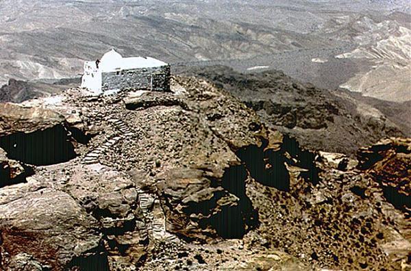
Walk a few hundred meters past the Theatre and take a rocky trail to the left. This eventually hits a dirt road that passes just above the Great Temple and that is followed for the majority of the hike. The first landmark is ‘Amud Fir’awn or the Pharaoh’s Column. This is the solitary column remaining of a ruined sanctuary (and apparently on the route to Egypt via Naqa al-Rubai). Just after the column, take the right fork that crosses through a large wadi (Wadi Ras Suleiman) and continues past several rock-cut tombs and many Bedouin homes climbing up to reach a shoulder where you get the first view of your destination, Jebal Harun with the white tomb of Aaron on top. Scan the south flank of the mountain to see the faint white zig-zagging trail. Cross two tributaries of the headwaters of another large wadi. Just at the high point after the first tributary, leave this main road and take a faint track heading west. Scan ahead to the right of the wadi to see the beginning of the trail that winds along the bottom of a hill. Cross the upper end of the wadi, pass in front of a small block building and head up aiming for the start of the trail. The trail is easy to follow to the top of the mountain. Most is slick rock cleared of all rocks. When on top of the cliff below the summit block, walk along the west side to the stairway on the north side of the mountain that ascends the cliff face: back to Wadi Musa and for hundreds of miles to the west and north. Climb the narrow stairs on the NW of the tomb to get onto the roof. Descend the way you came.
It took me 2 1/2 hours from just past the Theatre to the summit. On the flank of the mountain, I met a young Bedouin couple with a baby on a donkey. He offered a donkey for 20JD for the remaining hour to the top. I was only interested in walking. As the “keeper of the keys” to the tomb, he then offered to use the key to enter the tomb for 10JD. He discounted the view as being of any importance. We were miles apart on price.
Other Hikes. There are numerous hikes into the hills and siqs around Petra. You need a guide for any hikes requiring overnight stops (it’s not permitted to camp within Petra itself), but many other smaller trails can be easily hiked alone.
Umm al-Biyara. This is a steep hike up the imposing mountain whose sheer cliffs dominate Petra to the west. The steep, exciting route climbs 300m to 1160m at the top. Start as for Jebel Harun to Pharaoh’s Column and cross the wadi. About 100m after crossing the wadi, go right 50m left of some stone tombs. Pass through a rocky defile into a little basin surrounded by caves, up diagonally past more caves then zigzag left and right to enter the gully at a new wall. Ascend the gully on ramps and reach steps, ledges and more steps to the top. On top is an Edomite settlement and Nabataean sites and cisterns.
Refer to the book “JORDAN – Walks, Treks, Caves, Climbs and Canyons” (available in Hotel Saba’a for the many other hiking possibilities around Petra: Wadi Sabra, for example looks interesting.
A Suggested Plan For Seeing the Most of Petra
Two full days are a minimum to see all the good things. Three is ideal.
1. One day. Enter at the Siq and visit all the big sites: Museum at the entrance, Treasury, High Place of Sacrifices, Street of Facades, Theatre, Blue Church, Great Temple, Temple of the Winged Lions, Qasr al-Bint, Al-Habis (the prison), Crusader fort, Lion Tomb, Monastery and the great viewpoints beyond the Monastery. Walk back and go up to the Royal Tombs following the cliff around past all of them and go up the Al-Khubtha Trail to the viewpoints down to the centre of Petra, the Theatre and the Treasury. Return down the stairs and descend to the trail heading east above the Wadi and walk about a kilometre to the lower entrance of Wadi Muthlim. Go up this wonderful canyon to the top emerging at the entrance to the Siq. Return to Wadi Musa and your hotel.
2. Two Days. Climb Jabel Harun plus if energetic also climb up to Umm al-Biyara.
3. Three Days. Separate day 1 and 2 into its components to make for easier days: Al-Khubtha Trail and Umm al-Biyara for example.
After my enormous two days in Petra, I decided to take a day off and relax before heading down to Wadi Rum and Aqaba before going to Israel.
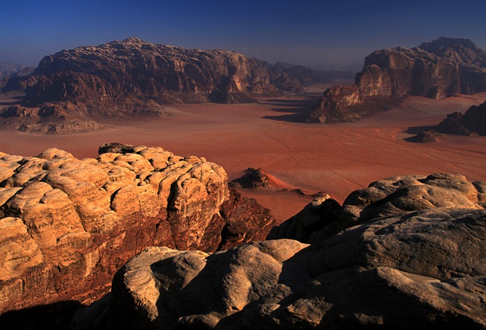
WADI RUM
TE Lawrence wrote about its sculpted rocks, dunes and Bedouin encampments in “Seven Pillars of Wisdom” in the early 20th century. A quintessential desert: extreme in summer heat and winter cold and gorgeous sun at dawn or dusk. It offers one of the easiest and safest glimpses of the desert in the region, most easily done by going on a 4WD tour and staying overnight in one of the desert camps. Besides tours there are camel rides but one hour is more than enough. There are no hotels in Wadi Rum but a huge selection of camping choices. Some desert camps are located near the village of Diseh, 16km from the Desert Highway.
There was no one else in the hostel who wanted to book a trip with Saba’a’s usual Bedouin guide, Saleem, so I got the bus at 06:20 with no reserved trip. There were five other Westerners on the bus: a Canadian from Toronto, and two Chilean women all with reservations for a jeep tour and overnight stay. However, two nice young Israeli women, Or and Tzippy, had no trip and I joined them. They were university students in Tel Aviv at the end of a 7-day trip to Jordan. Few Israelis visit Jordan as they believe that it is too dangerous and that they can’t go if they have been in the Israeli army (not true). Or and Tzippy thought Israel was more dangerous than Jordan. They had both done their military time in the Israeli Army in the infantry working as border security.
While the rest continued on the bus, we had to get off at the Visitors Center, pay the 5 JD entrance fee (free with Jordan Pass) and be at the mercy of the touts trying to sell tours. But Abraham from Saba’a Hotel had phoned Saleem and he was waiting for us there. He offered a 5-hour tour to all the sites for 75JD. He drove us into Rum Village where we went to a “supermarket” and bought tomatoes, cucumbers, large thin ‘tortillas’, hummus and oranges for lunch (instead of the 5JD per person lunch offered by Saleem). The Israeli girls did things as inexpensively as possible.
Wadi Rum is a large area of sandy desert interspersed among huge blocks of eroded sandstone. Bedouins live in blanket tent encampments dispersed all over the place. Herds of goats and camels are everywhere. Several rewarding hikes are walking through soft sand. A 3-hour loop hike goes from the visitor centre to the Seven Pillars of Wisdom and up Makharas Canyon curving around the northern tip of Jebel Umm al-Ishrin back to the visitor centre.
Seven Pillars of Wisdom. A large rock formation with 7 fluted turrets is near the Visitors Center.

Jebel Rum (1754m) is an enormous dramatic tower above Diseh. A 1st-century BC Nabataean temple is also near the village.
Lawrence’s Spring. A leaking black hose descended from high above into a trough full of algae and ran over to a group of tents. We scrambled up boulders a few hundred feet to the source of the spring, a tiny dribble from deep in a cave that flowed into a small rock basin that fed into the hose.
Big Sand Dune (6km). Not a dune per se but a cascade of red sand spilling down from a rock cliff on the slopes of Jebel Umm Ulaydiyya.
Jebel Khazali (7km). Formed by tectonic forces, this narrow siq had pools of water and ended at a difficult to climb pour off. We sat in a large Bedouin tent full of rock benches and had tea by a fire. There was no pressure to buy any of his merchandise, a nice change.
Wadak Rock Bridge (the “Small Bridge” at 9km). A small arch that was easy to climb.
At lunch in somebody’s tent, we talked about the book “The Ethnic Cleansing of Palestine”, which if you believe what the Jewish Israeli author says paints a very damning picture of Israel (this book will leave you with little sympathy for the Israeli cause). The leaders at the time hatched a plan to get 75% of the land (and they have) by bulldozing selected Palestinian villages and killing Palestinians. The women said that is just one opinion (and one held by many left-wing Israelis), but they didn’t believe it. “Palestinians didn’t do anything with the land and look what we have done”. “Palestinians only want 100% of the land so there is no point in negotiating with them”.
Burdah Rock Bridge (the “Big Bridge” at 19km). Another arch, this opening is 8m high. It was a good scramble up slick rock to get to the top to walk over the bridge.

Barrah Siq (14 km). A long picturesque 15m-wide canyon with a large sand dune in the middle.
Lawrence’s House (9km). In a remote location, this collapsed stone building was not used by Lawrence but was built for the movie ‘Lawrence of Arabia’.
We had some more nice Bedouin hospitality with tea. I got a ride with a German couple into Aqaba.
AQABA (POP 133,000)
On the Gulf of Aqaba, ringed by high desert mountains and with a pleasant climate year-round, it is the most important city in southern Jordan. It has the small-town atmosphere of a popular local holiday destination, but there’s not much to do for the tourist. It is a transportation hub en route to the diving resorts to the south, to Wadi Rum and Petra, by boat to Egypt and by land to Eliat, Israel.
Ayla. Located along the Corniche, this is the ancient port of Aqaba. It is incongruously squeezed between the marina and the Movenpick Resort.
Aqaba Fort. This squat 50m square fortification at the other end of the Corniche. Built between 1510 and 1517, it was used as a traveller’s inn for pilgrims on their way to Mecca. There is not much to see.
Aqaba Museum. Part of the fort, it was the home of the great-great-grandfather of the present king, Abdullah II. It has coins, ceramics and 8th-century Islamic stone tablets. There is not much to see and certainly not worth the 3JD fee (included in the Jordan Pass)
Diving and Snorkelling. The Gulf of Aqaba has over 110 species of hard coral, 120 species of soft coral and about 100 species of fish but no sharks or big fish. There are many good dive agencies.
Swimming. The café-lined beaches of Aqaba are aimed at sunset strollers rather than swimmers.
Boat Trips. Glass-bottomed boats to see fish but are expensive. You can snorkel.
Sindbad. Operate popular cruises around the Gulf of Aqaba and allow for snorkeling.
Aqaba Turkish Baths. Offer the full works – massage, steam bath and scrubbing.
Getting There and Away.
Boat. Two types of ferries operate between Aqaba and Neweiba in Egypt. Fares are paid in US$. The fast boat (US$75) leaves daily at 1 pm. The slower car ferry service (US$65) takes 3 hours or more and leaves at 11 am. You get a free Sinai permit on arrival at Nuwelba but not a full Egyptian visa.
To Israel. Cross at Wadi Araba (Yitzhak Rabin on the Israeli side). Open 6:30 am-10 pm Sun-Thu, 8 am-8 pm Fri &Sat. You can’t take your car or motorcycle through this border. Taxis are necessary to drive the 15 minutes to the border, walk across and take a bus (2 minutes) into Eilat.
I stayed at the Amir Palace Hotel (20JD) in Aqaba, a nice place. The next morning I visited the fort and museum and walked the corniche. There were lots of families having a picnic on the beach and many glass boats, but it is not an attractive beach. I dealt with a taxi to the border for 5JD. It took me an hour to get through Jordan immigration. The guy repetitively asked me “Why did you go to Afghanistan, Qatar, Bahrain, Kuwait, Iran?” (this confused me as I didn’t go to Iran), and on and on. He made 10 phone calls, took copious notes and finally let me go on. What was he going to do – deport me?
I half expected to not be allowed into Israel. I had to unpack most of my pack. I was asked to sit and expected a several-hour interrogation. On the bench was a woman my age from Anaheim who had been there for 5 hours and had been interrogated five times. She hadn’t eaten all day so I gave her all the food I had. After 10 minutes I got my stamp and was through!! I then hitchhiked into town (avoiding a 35 sheckle taxi ((US$8.75) for 3kms and stayed at Arava Hostel for 65 sheckles.
