
Denmark Aug 14- 2018
The ferry boarded at Torshavn, Faroe Islands at 23:30 on Aug 12. Early the next morning we passed the north end of the Shetland Islands with its lighthouse out on some rocks and geodesic ball on the high point of land. In my dorm bunkroom of six (couchettes in ‘Smyrlese’), there were no snorers and I had lovely sleeps both nights. The weather was grand for the entire sailing but we woke up to a complete, windless overcast on the 14th.
Day 1
The ferry from the Faroe Islands arrived at 09:30. The ferry rules are that you have to be out of your room 1½ hours before arrival and I was up at 7 to shower and have a leisurely breakfast with a last view of the North Sea.
I have done all my Nomad Mania sights for Denmark and entered them on the Denmark map – the number of places on the series lists (293 sights) is overwhelming, but I will try my best.
I made stops at my favourite German supermarkets, Lidl and Aldi to buy most of my groceries for a week, had a tank of relatively cheap gas from the Faroes and was all set to go.
HIRTSHALS (pop 6000)
This is the ferry terminus for all ferries seasonally to the Faroe Islands and Iceland and year-round to some Norwegian ports. A private train connects to Hjørring and from there on DSB trains to Aalborg and Frederikshavn.
Nordsøen Oceanarium. The largest aquarium in Northern Europe, it re-creates a slice of the North Sea in a massive 4-story tank. Having dived in the best places in the world, I find aquariums tiring and at this price, bankrupting. DK 180
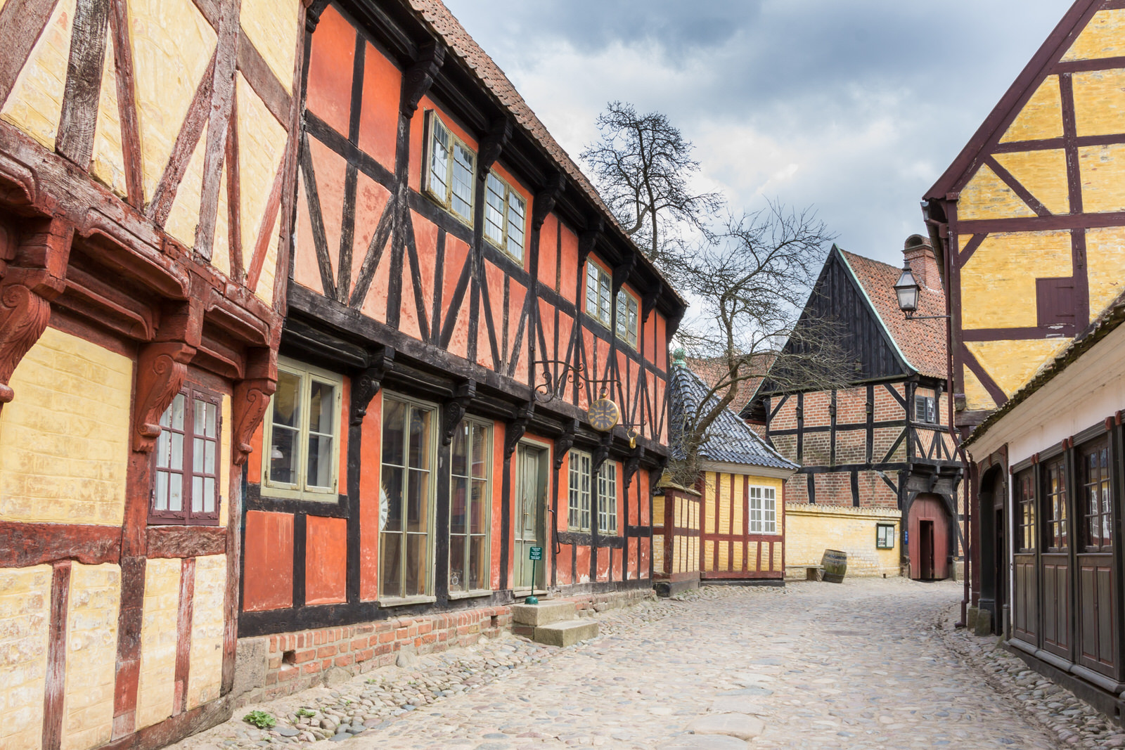
SKAGEN (pop 8200)
50kms NE of Hirtshals, drive through pine forests and then grassy sand dunes to get to Denmark’s northernmost settlement at the end of a long, narrow peninsula lined with beaches. Today Skagen is a highly popular tourist destination. All houses are painted annually in the same colours – yellow with white trim contrasting with the red, tiled roofs.
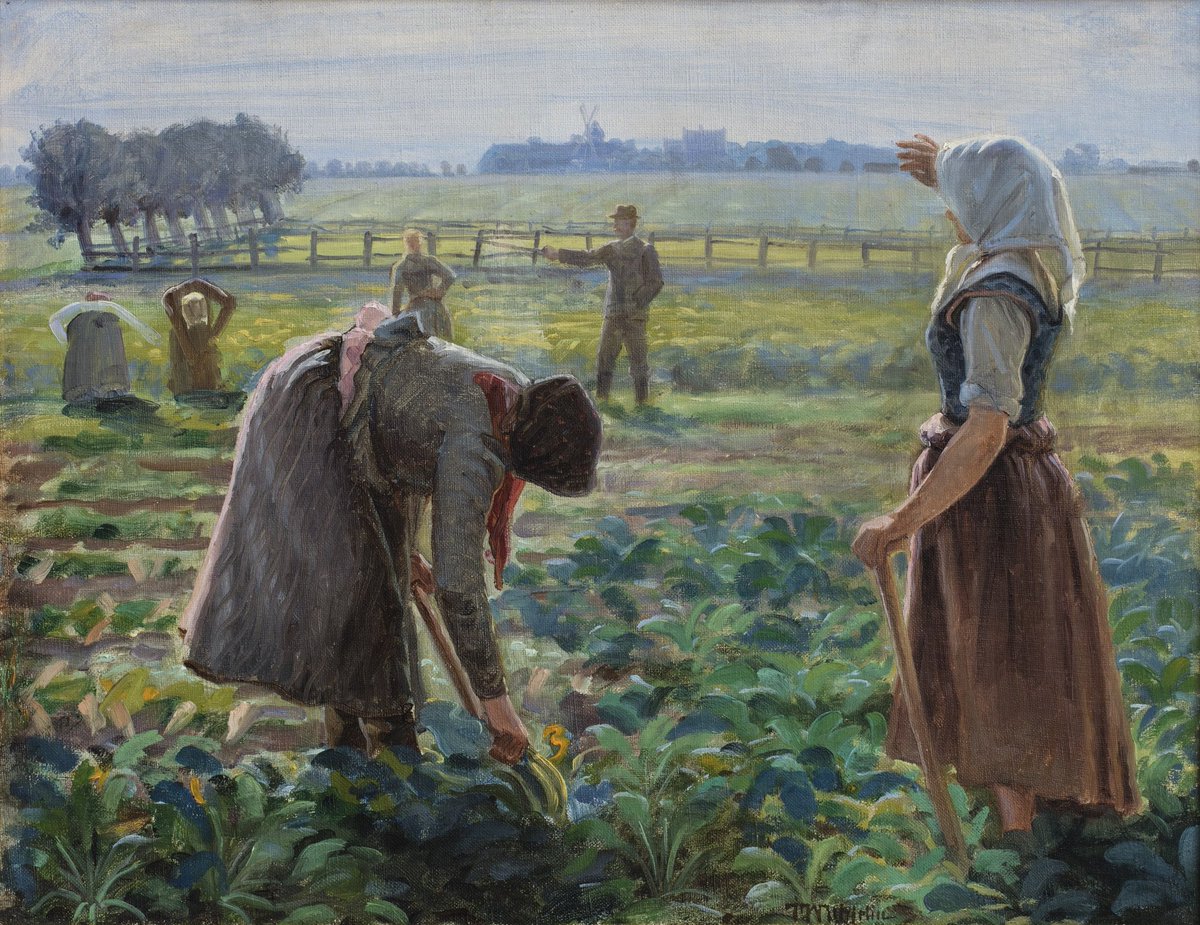
Skagens Museum. This gallery showcases the outstanding art produced in Skagen between 1870 and 1930, primarily by the painters Michael (1849-1929) and Anna Ancher and Oscar Björck who established a vivid figurative style of painting that became known internationally as the ‘Skagen School’. They had discovered Skagen’s luminous light and colourful, wind-blasted heath and dune landscape in the mid 19th century, documenting the area’s fishing life that had earned the locals a hard-living for centuries. These artists painted en plein air (out of doors), often regardless of the weather.

Den Tilsandede Kirke. Built during the 14th century, a sand drift that started in the 17th century eventually required the locals to dig their way in. The will of the congregation was broken in 1795 when they finally abandoned the church. The main part was torn down in 1810, but the white-washed tower still stands.
Skagen White Lighthouse. The original lighthouse here sits about 200m south – a black timber tripod with an angled beam on which a pot containing burning coal was raised and lowered. This replacement, a 21m, 1747 lighthouse, was initially red brick but was lime whitewashed in the early 1800s and has remained that way since. Until 1876, it also produced its light using a coal fire in a basket on the top – accessed by 2 staircases to reach the fire on the right side of the wind. It has been a signal station for ships at sea since 1871 and was used by the Germans in WWII as a lookout. It now functions as an art gallery on its five floors.
A husband/wife pair of photographers had wonderful photography, and I chatted for some time with the pleasant elderly gentleman.
From the top (DK20), one can see all four lighthouses in the vicinity: the original one above, Skagens ‘Grey’ LH, Basrule Light on the tip of Grenen, and Skagens West LH.
Skagen ‘Grey’ Lighthouse. This 46m red-brick lighthouse (appears grey from a distance) replaced the White LH in 1858 and is the 2nd tallest lighthouse in Denmark. If also functions as the Centre for Migratory Birds and conducts a daily bird count displayed on the side of a bench in LED lights. DK75 for the museum and to climb the tower.
Grenen. About 5kms NW of Skagen, this is the most northerly point in Denmark – where the rough Skageriak Sea meets the tranquil Kattegat Sea. At the parking lot is an art gallery, the Grenen Kunstmuseum (free), a viewpoint on top of a WWII German bunker, the grave of Holger Drachman (d. 1908), one of Denmark’s most famous poets and a marine artist, and Grenen Point, a 30-minute walk on the beach to Basrule Light at the tip of the peninsula.
FREDERIKSHAVN (pop 23,500)
This major port town has ferries that go to five ports in Sweden and Norway.
Frederikshavn Kunstmuseum. Located downtown in a municipal building with a library and swimming pool, this art gallery shows local artists. DK40
BANGSBO. This community is immediately south of Frederikshavn.
Bangsbo Kystmuseet. This old country estate has eclectic exhibits including a reconstructed 12th-century Viking-style merchant ship. On the estate is a botanical garden, trails through the woods, and a field (Dyreshave) full of gorgeous deer with white spots, a white belly, and wide antlers.
Bangsbo Fort. Next door to a functioning military base is this collection of at least 15 WWII German bunkers. The Bunker Museet gives access to the command, cinema, hospital, and interrogation bunkers (DK75). Five other bunkers on the edge of the cliff are free.
Day 2
Brøndeslev Vildmose Museet. On the western outskirts of the town of Bröndeslev is this museum about farming on the moors and digging peat. A farm has existed here from 1664 to 1978 when it was bought and converted into a museum completed in 2012. The tin-plate barn was moved here. There are multiple displays with motorcycles, a hair salon, a milk room, a blacksmith shop with a forge, a woodworking shop, farm machinery, implements, and wagons displayed in the large barn. DK50
Lindholm Høje. This Viking burial ground with nearly 700 graves covers a hilltop pasture 15 minutes north of the Aalborg town centre. Some of the graves are marked by stones placed in the oval outline of a Viking ship, although it gets lost amongst the many graves. The oldest graves date to the 600s, and these contain intact bodies dressed in their everyday clothes, swords, knives, and jewelry, and 223 with their dogs. Eventually, cremation became the method of choice for burials, all marked by stone circles and mounds. The cemetery was not used much after the late 900s when the Vikings became Christians and were buried in church graveyards. At the end of the Viking era, the whole era was buried under drifting sand, and the area was abandoned in about 1100, preserving it until modern times when it was excavated in the 1950s.

AALBORG (pop 130,000)
Denmark’s 4th largest city, it sits at the narrowest point of the Liimfjord, a narrow body of water that slices Jutland in two. The Liimfjord served as a kind of Viking motorway providing speedy access to the Atlantic for longboat raiding parties. The industrial areas of the city have been rejuvenated into a waterfront promenade with restaurants, a park, playground, basketball courts, moored boats, the Utzon Centre, a summertime outdoor pool, the university, low-cost student housing, and a 2014 futuristic concert hall.
Utzon Centre. This building on the waterfront has a distinctive silver roofscape, the last building designed by the celebrated Danish architect Jørn Utzon (1918-2008), who also designed the Sydney Opera House. The centre has changing exhibitions on architecture, design, and art – the present one is on Utzon himself with Lego constructions of many of his buildings and his father’s sailboat. DK 70
North Jutland History Museum. This is a collection of 14 museums with the one in Aalborg called the Aalborg Historical Museum. It details the history of Aalborg with displays on glass, WWII (10,000 German troops were stationed in Aalborg), factories producing whiskey and tobacco, the 1602 Aalborg room (the best-preserved panelled room in Denmark from the 1600s), and many artifacts through to modern times. Unfortunately, the write-ups are only in Danish – a booklet in English is available but I find these unpleasant to use. DK40
Defence and Garrison Museum (Forsvars-og Garnisons Museum). Located at the west end of the city in a large hangar originally built by the Germans as a seaplane base they established in 1940, there are airplanes, small arms, artillery, and a large collection of tanks and other military vehicles outside. Aalborg has been a garrison city since 1779 and displays details of the occupation from 1940-45 and the development of the Danish Total Defence since WWII.
Kunsten. This marble building is Aalborg’s museum of modern and contemporary art. I enjoyed the “sculptures” using clothes by Kaarina Karkkainen and the mosaics by Eri Frinlsen, but found the exhibits by William Kentridge (South Africa) and Michael Kivimäki the usual contemporary art “crap” that is only boring. The price was uncertain as I simply walked in. There are 7 small galleries, most with multiple paintings, but the descriptions are all at one end on one page, a poor way to exhibit.
Budolfi Domkirke. This 12th-century cathedral marks the centre of the old town. The whitewashed interior has a foyer ceiling with colourful frescoes dating from 1500, magnificent carvings best seen on the gilded baroque altar, the Ways of the Cross on the detailed pulpit, and flowers and crests on the aisle end of the pews. Free

Rold – Circus Museum. Rold is a small village 33 km south of Aalborg. There is a large circular wood circus “tent”, an old circus wagon, videos, posters, unicycles and bicycles, and many wonderful performers’ costumes. All explanations are in Danish only. The only circus still functioning in Denmark may be the Benneviers. DK40
Mariager. In the Nomad Mania ‘small town’ series, this village sits on a large interior fjord. The highlight is the Kloster og Kirke, originally a medieval monastery of the Bridgettine Order started here in 1446 (both nuns and monks) and is now one of the largest churches in Denmark. It functioned until the Reformation in 1536, noblewomen continued until 1588, and most were pulled down in the 1780s. The whitewashed interior has a magnificent altar with a bas-relief of the Last Supper and gilded statues of most of the saints. At the back is an unusual coffin containing Jesus and the ropes for the bells. Grave slabs on the floor, a ship, and very stylish 12-armed chandeliers complement the simple interior.
Possibly the nicest thing here is the church graveyard with one or more graves each surrounded by lovely hedges (like a Renaissance garden) and planted with flowers and ornamental shrubs.
Spentrup – Blicher Mindestue Malvinas Hus. Steen Steensen Blicher (1782-1848) was a famous Danish poet and parson who lived in the priest’s house here in the village of Spentrup for 25 years. The thatched house was lived in by his daughter, Malvinas, and her husband and now serves as a small museum. Blicher’s grave is in the church graveyard next door. Write-ups are in Danish only. DK20
RANDERS
This is the largest city in the area and home to a few eclectic sites. Note that most of these museums close at 4 pm.
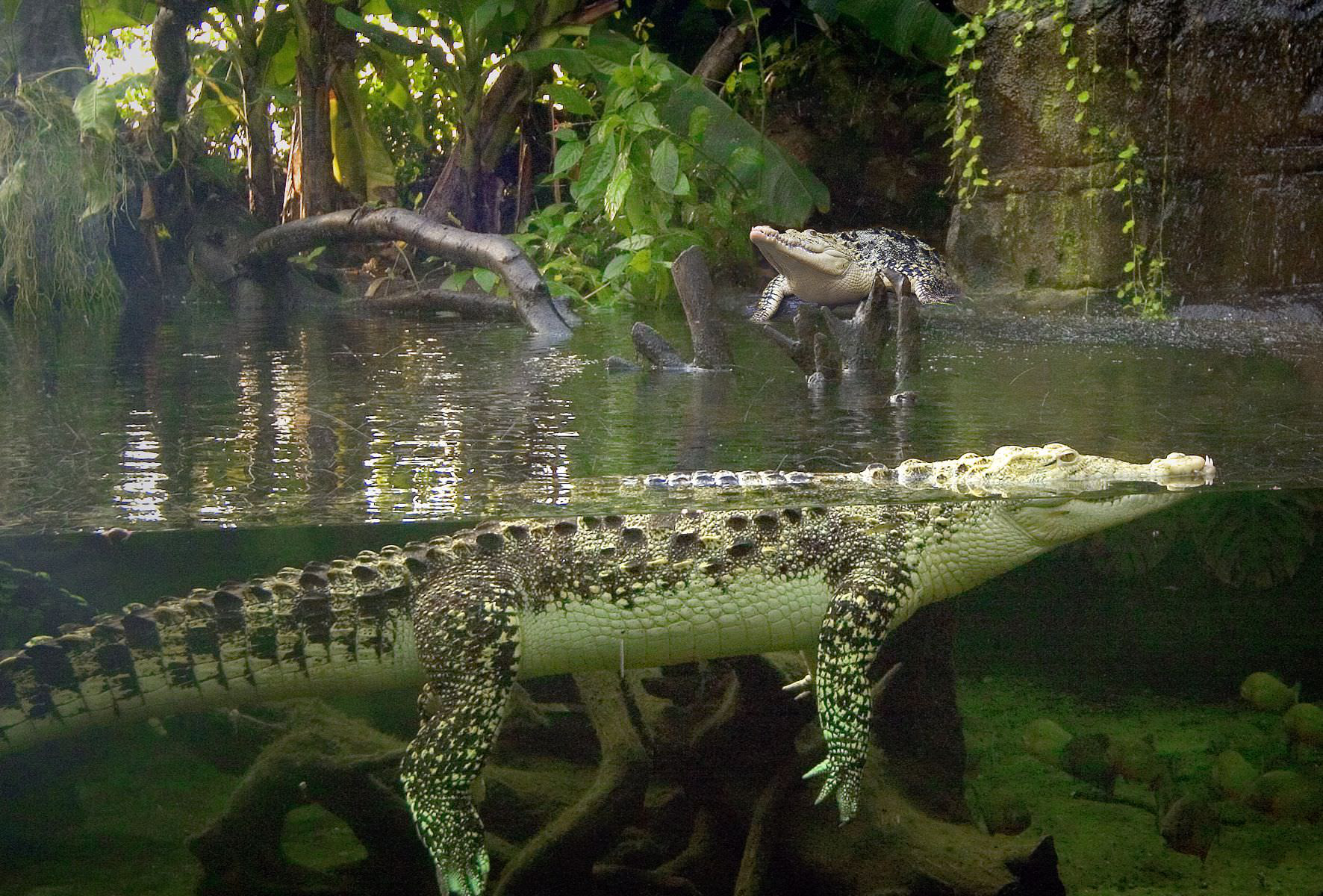
Randers Regnskov. This tropical zoo is enclosed in 1 large and 2 small geodesic domes recreating the tropical environments of South America, Africa, and Asia. Enclosures have crocodiles, jaguars, a manatee, monkeys (lemurs mostly), sloths, iguanas, snakes, orchids, and hibiscus. There are no large cats or mammals other than the jaguar. Open till 5 pm. DK190, season pass 295.
Østiyllands Museum (East Jutland Museum). Housed in a large municipal building with the Kunst Museum and Library, this tells the archaeological history of Randers from the Stone Age through to modern times with well-done displays. Free
Randers Kunst Museum. This has a wide-ranging collection of art from the Randers area. Free, DK50 for the special exhibit on Ultima Thule (primarily Greenland).
Gaia Museum of Outsider Art. Displays artists not usually in galleries.
Memphis Mansion. Two km southeast of the city is this Elvis Presley Museum housed in a replica Graceland mansion (double the size of the original). It is a showcase for one obsessed fan’s collection of memorabilia. The highlight may be the shop with an all-encompassing collection of books, vinyl, CDs, movies, and knick-knacks. The American diner is the big money maker here. Open till 9 pm. DK99
Day 3
DJURSLAND PENINSULA
This peninsula juts out from the east side of Jutland into the Kattegat Sea.
Gammel Estrup Manor (The Danish Manor Museum). About 12 km SE of Randers in the Danish region of Djursland, this imposing 4-story, moated manor house and is entered from a cobbled square surrounded by grand outbuildings, ponds, and lakes. Dating from the 14th century, it was owned by the same wealthy family until 1926. It is full of beautiful art, furniture and ceramics has a functional kitchen and a baroque garden with orangeries. Activities and exhibits show the life of Danish noble families and their estates and manors. Visitors are invited to picnic in the garden or on the lawns. DK100
Kattegat Centre – Grenà. At the east end of the town of Grenà, this aquarium has 250 species from around the world including sharks and seals. Kids can feed, catch, touch, and taste critters, adults can dive and kayak on the ocean. DK165, 185 for a month pass, 325 for a year.
Fornæs Lighthouse. On the east end of the peninsula 5 km from the aquarium, this is a brownstone lighthouse. There were no signs or information if the light could be climbed. An engineering firm had only access to the beach.
EBELTOFT. In the Nomad Mania “small town” series, the village is also in the “sight” series. The cobbled street above the harbour is several blocks of half-timbered buildings with shopping and knickknack stores. There are several glass studios around town. The original 1789 town hall is now the local museum complete with paintings of all Danish kings and a dungeon. Free
Ferries connect to Zealand.
Frigate Jylland. A ship museum in the harbour, it was built in 1860, the world’s longest sailing ship. It took 18 direct hits in the Battle of Heligoland, then sailed around the world until 1887. It sank and was rejuvenated as a gorgeous three-masted boat with a black and white hull and bristling with cannon. DK125 to see the ship and museum.
Glasmuseet Ebeltoft. Next to the Jylland on the water is this museum on contemporary glass featuring international artists. It also has 1500 pieces in its permanent collection including the “Cosmic Space’ by Faroe islander Tróndor Patturson. Demonstrations on glass blowing allow visitors to blow, cast, and fuse glass. An interactive learning centre shows how glass eyes and light bulbs are made through the history of glass. DK175
MOLS BJERGE NATIONAL PARK. The last ice age glacier, 18,000 years ago, stopped in the area – ice tongues cut the bays of Kalø Vig and Ebeltoft Vig and left the undulating hills surrounding the bays. Melting ice left depressions called kettle holes and glacial erratics litter the landscape.
Jernhatten. This 49m-high cliff gives good views of the island of Hjelm.
Ørnbjer Mølle. This watermill still functions. Many hiking trails start here.
Trehøle, the three Bronze Age burial mounds 127 above sea level, give panoramic views.
Kalø Castle. This 700-year-old castle ruin is reached by a ½km causeway from near Rønde. It is the most popular attraction in the park.
Rosenholm Slot (Castle). In Hornslet, this is another grand country manor house after the style of Gammel Estrup – surrounded by a moat, it is 4-story, red brick with square towers in the front corners, a square central tower mounted by a copper spire and round towers at the back, and is much larger than Gammel Estrup. A large square of outbuildings is to the south – all is private.

AARHUS (pop 310,000)
Denmark’s second-largest city has many museums, a thriving university, and the country’s best music scene. It was the European Capital of Culture in 2017.
Aarhus Card. Gives free admission to the city’s 25 museums (plus several in the area including Randers Regnskov and Gammel Estrup), free travel by bus and light rail, free parking and shopping discounts. Also included are tour guides, hop on, hop off buses, Tivoli Amusement Park, Rush (trampoline park), ice skating, horse racing, swimming pools or watching the local handball team and football team play. Unfortunately, it can only be bought at the bus station and hotels. Only one museum, the Women’s Museum sells it. Buying it online is not practical as it is mailed and takes one week. 24 hours DK299, 48 hours DK449.
University Area
Antic Museet (Museum of Ancient Art). Almost everything here is plaster copies of Greek statues including the friezes of the Parthenon. In the basement is an Etruscan exhibition but pieces of interest are few. Danish only. Free
Museum of Natural History. Has many stuffed animals especially from the African savanna. Discusses the human impact of climate change and gives a unique perspective on evolution. DK90
Steno Museum. Has exhibits on the history of science and medicine, a herb garden, and a planetarium. DK50
Museum Ovartaci. In the 1852 University Psychiatric Hospital, one section details the history of psychiatry. The second section is art by psychiatric patients concentrating on that of Louis Marcussen (1894-1985), a patient here for 56 years. He chose the name Ovartaci, His art is displayed along with that of other psychiatric patients. Trained as a house painter, he emigrated to Argentina where he experimented with psychoactive drugs. He was schizophrenic and wanted to be a woman (was castrated and self-amputated his penis using a carpenter’s plane, had gender reassignment surgery, and then changed his mind and wanted to be a man again). The museum tries to destigmatize psychiatric patients. Danish only DK50
Downtown Area
Aarhus Domkirke. At 100m, this dark-red brick church with its green copper roof and spire is Denmark’s longest church. The chapel at the eastern end is the 13th century but most of the rest dates from the 15th. It was once richly decorated with frescoes that were whitewashed after the Reformation of 1536, but many have been restored. A highlight is the five-panel gilt altarpiece carved in the 15th century. Free. DK 20 to climb the tower.
Women’s Museum. Housed in the old city hall built in 1857, its main permanent collection, called Gender Blender, discusses gender issues. Theatre Life shows how women’s freedom has grown using artifacts from the 117 years of the Aarhus Theatre. A holocaust survivor tells her personal experiences. They sell the Aarhus Card. DK90
Viking Museum. A satellite museum from the Moesgaard Museum, it sits on old Viking ruins. DK30 is payable at a machine.
Near Downtown
Kunsthal. This small museum with one gallery had an exhibit called ‘Post Institutional Stress Disorder. I found the graph showing the growth of American prisons, and prisoners sobering.
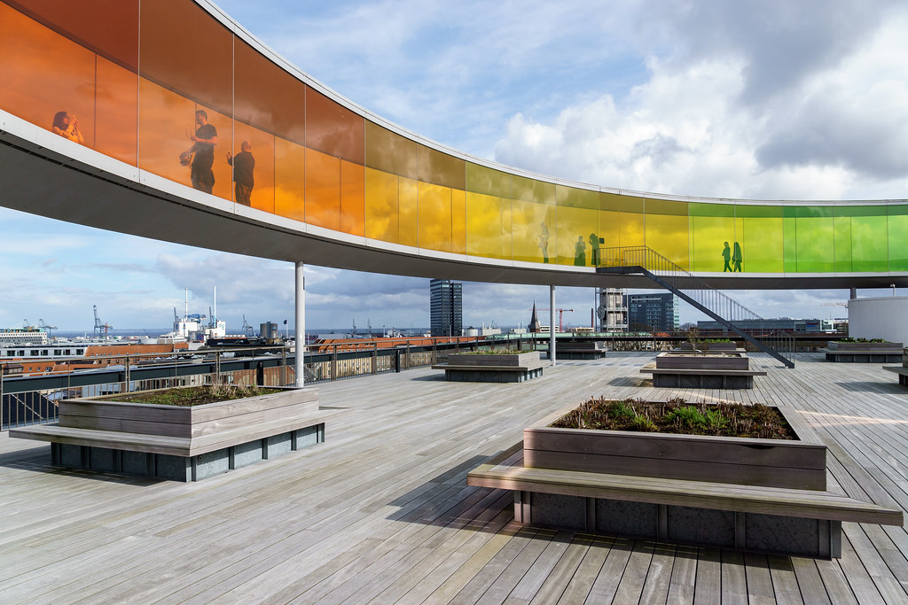
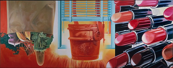
ARoS Aarhus Kunstmuseum. Aarhus’ showpiece art museum, a red-brick cube has 9 stories of curved galleries and the 10th-floor Rainbow Panorama, a round walkway of coloured plexiglass. Besides permanent collections (Danish Golden Age works, the 5m-high sculpture of a crouching boy), the highlight exhibit was by the American James Rosenquist with huge collages in vivid colours – spectacular. DK140

Den Gamle By. This open-air museum of the Old Town has 75 half-timbered houses brought here from all over Denmark to construct a provincial market town. Each building has craftspeople practicing their trade and small retro museums (posters, toys, decorative arts). Neighbourhoods from 1927 and 1974 (an apartment building) are also recreated. DK135 Outside opening hours, you can stroll the cobbled streets for free.
Harbour Area
Salling Tåinet. A 2015 metal sculpture on the water’s edge with an internal staircase.
Watersports complex. A swimming pool with a choice of water depths, sand volleyball courts, and small eateries compete with all the construction going on here.
Dokk1. Art exhibitions, a cafe & the main branch of the Aarhus Library in a striking waterfront building.
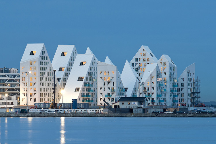
The Iceberg. In the NM ‘modern architecture’ series, this apartment complex is all angular shapes, white, turquoise plexiglass balconies, and triangular windows.
Aarhus Lighthouse. Google Maps took me to a reclaimed corner of the quay where the new Aarhus Lighthouse is being built. Sections of cylinders (think wind turbines) will be joined to create the highest structure in Aarhus. Go to www.lighthouseaarhus.dk to see the information. Nearby are two small lighthouses guarding the entrance to the ferry harbour, one on a rock spit and the other at the end of this same quay.
Aalekvasen Anna. In the NM ‘Things to do’ series, Google Maps brought me to this wooden boat harbour. One of the owners directed me to this 1907 black-hulled sailboat that offers chartered sailing trips – wwwaalekvaseanna.dk
Things in NM I didn’t see were: the Ole Romer Observatory, Marselisborg Palace, and the Moesgaard Museum.
Day 4
I slept in a lay-by just west of Aarhus, a very overbuilt project with hundreds of parking spaces, a playground, and an extravagant walkway with benches – Dutch truck drivers would be envious. And there is very little large truck traffic in Denmark.
THE LAKE DISTRICT
This is a somewhat misleading name as it is simply a gently hilly region with a few medium-sized lakes, Denmark’s highest point, Yding Skovho, the country’s longest river, the Gudenå, and Jutland’s largest lake, the Mossø. There are many opportunities for canoeing, biking, and longer-distance hiking. The 30km track of the old railway between Silkeborg and Horsens is good for both cycling and walking.
SILKEBORG (pop 42,500)
Just an hour west of Aarhus, this is the Lake District’s largest city and a base for exploring the forests and waterways around.
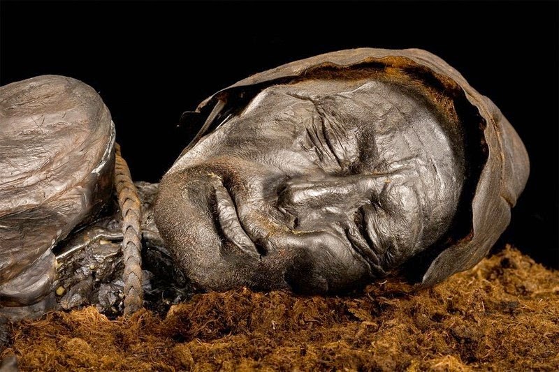
Museum Silkeborg. This museum is famous for the Tollund Man, a 2350-year-old, incredibly well-preserved Iron Age “bog man”. Leathery and black, he appears to be simply asleep. His face has detail right down to the stubble on his chin. He competes with the Grauballe Man at Aarhus’ Moesgaard Museum as the best ‘bog man,’ but I believe this one wins. Both their lives and deaths remain a mystery. Three rooms also have the usual Stone Age, Bronze Age, and Iron Age exhibits. DK65
Museum Jorn. This art museum has many of the 5500 works of native son Asger Jorn and 15,000 of other modern artists. This is the sort of art that has little appeal to me. There was also a large exhibit of woodcuts by Per Kirkeby. DK100, 90 concession
VIBORG (pop 38,800) During its holiest period before the Reformation, there were 25 churches, now only two remain.
Skovgaard Museet. This art gallery shows works by several members of the same family, the Skovgaards: Peter, the father (1817-75) and his three children, Joakim (1856-1933), Niels (1858-1938), and Susette (1863-1937). Niels is the star but all produced wonderful art typical of the Golden Age of Danish painting. The family traveled to Norway and Italy and many paintings are from those countries. DK60.
Viborg Domkirke. Next door to the museum is the largest stone church in Scandinavia with simple frescoes by Joakim Skovgaard covering the aisle walls, dome and ceilings. DK20
LIM FJORD
The Limfjord is a shallow sea regarded as a fjord since the Vikings. However, it has inlets both from the North Sea and Kattegat Sea and hence separates North Jutland Island from the rest of the Jutland Peninsula.
It extends from Thyborøn Channel on the North Sea to Hals on the Kattegat. It is approximately 180 km long and of an irregular shape with numerous bays, narrowings, and islands, most notably Mors, and the smaller ones Fur, Venø, Jegindø, Egholm, and Livø. It is deepest at Hvalpsund (24m).
Its main port is Aalborg, where a railway bridge and road bridge are built across while motorway E45 passes it through a tunnel to the east. Commercial ports also exist at Thisted, Nykøbing Mors, Skive, Løgstør, Struer, Lemvig and Thyborøn. There are also bridges at Oddesund, Sallingsund, Vilsund, Aggersund, and Sebbersund, and several ferry crossings.
History. Western opening – An isthmus of shifting sand separated the Limfjord from the North Sea during historic times. A passage existed during the Viking age south of the present one. Canute the Great sailed into it in 1027 on his way back from England but it closed around 1200. There are records of several floods piercing the isthmus during the 16th to early 19th century.
Eastern opening – There has been an opening to the sea in the east from the early Middle Ages until February 1825 when a flood pierced a permanent opening, the so-called Agger Channel, in the north of the 13 km long and less than 1 km wide isthmus, the Agger Tange, which had until then linked Thy with the rest of Jutland. The western part of North Jutland lost its road connection with mainland Jutland, but the towns and harbours in the western part of the Limfjord benefited from becoming directly accessible from the North Sea to the dismay of Aalborg. From the 1840s the route became increasingly important, as Britain had opened for the import of grain, and ships could return with British coal. However, the instability of Agger Channel made the towns of the western Limfjord look for a second option when the North Sea broke through from the west and created a second opening, turning the northern part of Jutland Vendsyssel-Thy into an island. The present inlet, Thyborøn Channel, has existed only since 1862.
In 1862, a flood pierced another opening, the Thyborøn Channel, through the remainder of Agger Tange. Agger Channel was continuously filling with sand and eventually closed in 1877. Since then, the remaining Thyborøn Channel has been kept open and navigable through dredging. The harbour of Thyborøn was built in 1914-18 and a town was founded. The two isthmuses have shifted eastwards since the 1800s. They are only being preserved by groynes, persistent sand pumping, and two road dams along their inward (eastern) side.
Løgstør Banks and Frederik VII Canal. At Løgstør, where the wide western part of the Limfjord meets the narrow eastern section, the infamous sandbanks of Løgstør Grunde were an obstacle to ships. Larger ships needed to be unloaded and reloaded when passing the banks. The Frederik VII Canal at Løgstør was completed in 1861 to allow for easier passage. Traffic had increased after the western opening at Thyborøn became navigable. The sandbanks were finally dredged out in 1901, rendering the canal obsolete. The canal is now a well-preserved heritage site.
In periods of persisting western winds, flooding occurs at low-lying land and harbour areas in the towns of the western Limfjord, since the water can’t escape through the narrow, eastern part of the Limfjord.
Biology and climate. The western breakthrough of 1825 changed the waters of the Limfjord from brackish to salty with a considerable current from west to east. Hypoxia sometimes occurs due to warm, windless periods in summer or ice in winter. The fjord has today oceanic salinity at all depths. Many animals and maritime plants found in Skagerrak, Kattegat and the North Sea are found in the fjord. Due to its shallow waters, the temperature rises rather quickly during warm and sunny days from mid-April to early September. In winter, ice can form faster during cold periods, especially in bays with little current.
The Limfjord is notable for its tasty mussels. Gourmets appreciate its oysters considered to be of extraordinary size and quality. Without the Western breakthrough in 1825, these mussels wouldn’t grow as well as they do in the oceanic salinity waters.
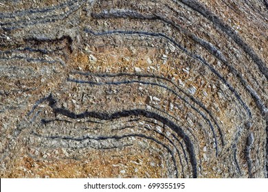
MOLER LANDSCAPES OF LIIM FJORD
The clayey diatomite is commonly known as “mo-clay” (Moler) of the special factors that brought about its creation, its special blend of diatoms, clay, and volcanic ash, its specific history of maturation, and the extraordinary diversity and volume of its fossils, is unmatched anywhere in the world.
It is found only at locations in the western Lim Fjord region in the northwest of Denmark, the largest and most impressive deposits being those on the two islands of Mors and Fur. Smaller seams are found in the surrounding areas of Thy (Silstrup), Salling (Junget) and Himmerland (Ertebølle).
Mo-clay is a very rare sediment composed of diatoms, a type of algae, from the Lower Eocene (56-54 million years ago) bordering on the Paleocene Era. The mo-clay contains about 200 distinct layers of volcanic ash deposited over 1½ million years, correlating with the volcanic history of what is now Greenland, the Faeroe Islands, and Great Britain, and to the opening of the Atlantic Ocean, which brought about the creation of the map of the world as we know it today. This permits both relative and absolute dating of ash layers and, hence, unusually precise correlations across a vast area of environmental impacts.
This landscape of hills and cliffs contains mo-clay deposits 60 meters deep that contain exceptionally large quantities of fossils of a diversity that provides a perfect record of both aquatic and terrestrial life from a period about 10 million years after the massive extinction event that brought about the demise of the dinosaurs:
Birds – more than 30 species, probably the best fossils in the world with feathers and chromatin. Reptiles – snakes and probably the “world’s best turtles”. Fishes – representing diverse species, including possibly the earliest truly deep-water fish, with rare and spectacularly large and intact specimens, such as tarpon. Crustaceans – of great regional importance, e.g. shrimps. Insects – more than 200 species, many with colour spots, eye lenses, including grasshoppers with sound apparatus. Plants – flowers, trees (redwood up to nine metres), many seeds, and fruits. Diatoms – more than 130 species.
The mo-clay and ash layers were displaced and folded by the great glaciers during the latter part of the last ice age, giving rise to an extraordinarily beautiful and dramatic environment. The hills and cliffs stand in contrast to the fjord – with the natural walls of pale yellow clay accentuated by dark bands of volcanic ash.
The area covers a total of 200 km2, most of which is privately owned farming land – a use that does not conflict with the need for conservation. The coastline and cliffs are under a conservation order that strictly prohibits building and quarrying. Specific landscape features in the area are protected, such as the cliff of Hanklit. Hanklit is also a designated an international geosite. Skarregaard in Hesselbjerg is owned by Morsø Municipality and managed by the historical museum. The “cape” of Mors, called Feggeklit, is also under full conservation.
Excavation of mo-clay for industrial purposes started in 1903 and inevitably left scars in the landscape, but certain areas are protected from further excavation.
The state of preservation is extremely good, with details rarely seen elsewhere, and permitting very reliable palaeobiological reconstruction. Some fossils are in 3D, and many of them are the earliest known representatives of their orders. 60% of the finest Danish fossil specimens were found in the mo-clay area.
Huge pseudomorph crystals (1½ metres) and the Stolleklint clay mark the beginning of the Eocene era, with great significance for theories on ocean bottom temperature, climate, and diagenesis and are highly pertinent to the current debate on rapid climate change.
This landscape of land elevations and fjord holds great dramatic beauty, of a kind seen nowhere else in Denmark or even anywhere else in the world. This region is perhaps the most concentrated and readily accessible site in the world for research in all the major geological disciplines.
Comparison with similar properties
Diatomaceous deposits exist in many other places. There are chalky, marine diatomites in the Mediterranean Region, along with fish fossils, but these are of much earlier date (less than 10 million years old), and their ash series are far less extensive. California has the deepest marine diatomite layer at around 300 metres of the same age as Lompoc, again with many fish fossils but only a few ash layers. None of these so far are World Heritage sites. Small diatomaceous lake deposits are known worldwide, some with limited series of ash layers, many with a low diversity of fish and many insects, and most of them are much more recent than the mo-clay occurrences and scarcely comparable.
Due to the very extensive series of volcanic ash layers, constituting the most unusual feature, the deposits of the mo-clay region are difficult to compare with other regions and sites. The uniqueness of the region from a global perspective also derives from the wealth of diverse geological phenomena within such a limited area. This is remarkable and only adds to its scientific and educational potential.
FUR ISLAND. This small island juts into the middle of the fjord. It is in the NM series “XL”. The 3-minute ferry costs DK20 (passenger) and DK120 (vehicle). The island appears identical to the rest of Denmark. I walked 2.5 km from the ferry past the church to see the museum.
Fur Museum. It has many fossils many from the Moher deposits, many with great fish, a fishing boat, and a fisherman’s house.
MORS ISLAND. In the NM “island” series, this large island in the fjord has easy access with bridges on both sides.
Jesperhus. I have a hard time accepting this inclusion in the NM “Sight” series, as it is simply an amusement park for children – little children. The grounds do have lovely flowers though but hardly worth the steep admission. DK185, 155 concession
THY NATIONAL PARK
This is Denmark’s largest wilderness, covering a 55km long swath of the North Sea coast in northwest Jutland. Ranging from 5-12 km wide, it is primarily coast, dune, dune heaths, pine forest and wet hollows. Hiking, biking, camping, horse riding, fishing, and bird watching are all available. Visit www.nationalparkthy.dk
Fishing from the beach in small boats was a traditionally dangerous job. Originally, a tongue of sand separated the sea and Liim Fjord, but in 1825, the sea broke through into the fjord, making it saltwater but also providing a safer landing for fishermen. Lodbjerg Fyr. The highlight area of the park is this 1883, 35m-high lighthouse. Even though there is an extensive renovation happening, it is still possible to climb the 133 steps of the spiral staircase to the top for panoramic views. Even though it is at least ½km from the shore, the light is visible for 25 km. It is still functional and automated.
Drifting sand has buried farms, fields and villages along the coast, including Lyngby, an old fishing village. DK20
A camping area with free shelter and a bonfire area is next door. Take trails from just north of the lighthouse through the dune heath to the 40m cliffs above the ocean.
I slept at a McDonald’s in Struer as I needed wi-fi to catch up on a lot of business. From Struer, I headed west to the coast and drove the entire west coast of Denmark and then across the south to Sönderborg.
Day 5
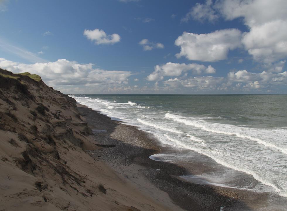
The highway travels right next to the ocean most of the way, but you rarely see it as a high, lyme grass-covered dune is in the way. Cross at least three narrow strips of land separating the ocean from large inland lakes: first Bövling and Nissum Fjords, then Vest Stadil Fjord, a freshwater lake, and finally Ringkøbing Fjord, a huge body of water with a circumference of 110kms bordering Hide Sande. There are many small towns and holiday homes scattered on the beachside – many have thatched roofs and are surrounded by built-up dunes and trees to protect them from the relentless wind. High, three-legged sea marks on the top of the dunes used to show ships where they were on the coast. Each is unique but no longer functions as sea marks (I thought they were metal sculptures).
Hiede Sande. In the NM “XL” series, this is a 30km-long narrow strip of land on the west side of Ringkøbing Fjord. Søndervig Beach.
Tipperne National Park. A bird sanctuary established in 1928, this is a small, obscure national park – the tiny area at the tip of the pancake-flat peninsula north of the town of Nymindigab on the south end of Hiede Sande. Turn north and stop at the big red metal building at the end of the pavement, the unmarked visitor’s centre. About 2000 cattle are put out to pasture on the peninsula, eat 7000kg of hay and gain 90kg during the May to October period. The cattle are an important part of the bird’s existence – the birds prefer the open fields and if it were not grazed, it would be overgrown with reeds and small trees. Reeds are also gathered for thatched roofs. Hit gravel for about 4 km and drive through pastures full of cattle to the tip where there is Tipperhus, a lovely brick house with a thatched roof. It is open with an unlocked door to a room with a big table. Next to it is a tower/bird blind. There are even some birds but a long way off in the shallow water. There are no signs or brochures that say anything about the park. Surprisingly there were actually 4 older people here to see the “sights” – all kind of a waste of time, but an NM tick.
