
The Kootenay River Trails are a network of walking trails along the east side of the Kootenay River above the confluence with the Columbia River and the community of Ootischenia. There are relatively level walks along the river and more strenuous ascents to viewpoints on Dove Hill and Brilliant Overlook. The trails are rich in the history of First Nations people and the local pioneers. Primary access is via Hwy 3A and the Castlegar Golf Course.
There are several trailheads and access roads to access these trails.
1. Access from the Park and Pool on Hwy 3A: Leave Castlegar heading towards Nelson on Hwy 3A. Just before the Brilliant bridge crossing the Kootenay River, turn left on Rosedale Road. The Park and Pool is the immediate right bordering the highway. Cross the highway to the Brilliant Substation parking area and the start of the trail.
2. Access from Castlegar Golf Course and Dove Hill Trail. Leave Castlegar heading towards Nelson on Hwy 3A. Before the Brilliant bridge crossing the Kootenay River, turn right on Ootischenia Road and head up the hill. Follow signs to the Castlegar Golf Course: turn left on Corrigan Road turning into Columbia Road and then turn left on Aaron Road. Stay on pavement to the gate to the golf course. Park on left before the gate or turn left onto a dirt road at the Dove Hill Trail sign, after golf course gate 1/2 kilometre before the clubhouse. Park in the pull out to the left.
3. Access from the Brilliant Substation Parking Lot: Leave Castlegar heading towards Nelson on Hwy 3A. Before the Brilliant bridge over the Kootenay River, turn right on Ootischenia Road and head up the hill. Follow signs to the Castlegar Golf Course: turn left on Corrigan Road turning into Columbia Road, then turn left on Aaron Road, and head up the hill. Before the top of the hill, turn right on gravel road called McPhee Creek FSR with gate (note gate closure times), follow for 2km, keep left at fork and continue 2km to the parking lot before the substation.
4. Access from Glade: Head north on Hwy 3A towards Nelson. Turn right after the lumberyard at the Glade Ferry sign. Cross the Kootenay River on the Glade Ferry. Take the first right on Glade Road. When this road turns to gravel, continue on for 2.7km. Park at the erratic (large out of place rock on right).
THE DOUKHOBOR WATER SYSTEM
The development of irrigation systems in the Doukhobor communities were of prime concern, and by 1912, two irrigation systems were in place in Ootishenia. A concrete tank measuring 75’ x 125’ and 14’ deep was built. It held 1,000,000 gallons when full and was supplied by mountain streams. Located on the second terrace, it operated by gravity, providing water for several villages. A steam-driven four-cylinder pump was located on the Kootenay River, supplying water to the reservoir through a 14 inch wooden pipe. A mill to manufacture staves for the wooden pipes was constructed in Ootischenia. The irrigation system was over several miles long.
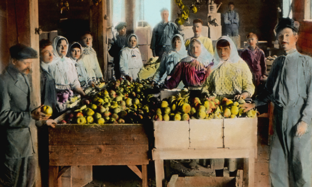
Ootischenia had the largest population of all the Doukhobor settlements in BC. It was in Brilliant where the largest commercial enterprise existed – the Brilliant Jam Factory.
The irrigation system was further developed with water from Pass Creek being brought in by wooden pipes to the Brilliant area. It was distributed by gravity flow. Two small systems located on the banks of the Columbia River brought water to the lower bench in Ootischenia in 6-inch wooden pipes to provide irrigation for the orchards. Staves for the pipes were supplied by mills in Champion Creek and Ootischenia.
In 1916, more land was acquired by the Doukhobors including the 2000 acres of timber south of Nelson. In Ootischenia, 1000 acres were added to the lands there, extending toward McPhee and Little McPhee Creeks, and bringing in much needed water supplies from the creeks. The rich soil of the Raspberry area was added to the Doukhobor community and holdings in Pass Creek were extended by over 3,000 acres. Other land purchases included 360 acres in the Slocan Valley, and 240 acres across the Kootenay River from Shoreacres.
Brilliant, Ootischenia, Pass Creek and Shoreacres had orchards within a short time. Ootischenia had the majority of orchards, producing apples, pears and cherries, most located on the second terrace. Grains, strawberries and potatoes were also grown there, Flax for linen clothing was grown in Ootischenia, Champion Creek and in the Slocan Valley.
By 1911, more than 50,000 fruit trees had been planted. There was great demand for wood during WWI and vast tracts were cleared in Ootischenia with the second terrace and the side hills between the benches cleared of underbrush and logged by 1921. By 1922, the sixty acres on the upper bench were also cleared.
1925 photo
The irrigation system in Brilliant-Pass Creek was efficient, so it was decided to expand it by replacing the 15 inch pipe with a 24 inch pipe which was also made of wood staves. The new pipe crossed the Kootenay River on the bridge at Brilliant. However the wooden pipe would not withstand the pressure of water and pumping to the reservoir failed. Several Ootischenia villages obtained their domestic water from this system. The system feeding Ootischenia from McPhee and Little McPhee Creeks supplied water until 1953. A forest fire in 1933 destroyed the wooden pipes, trestles and small pipes leading to the reservoir and damaged the watershed. This greatly reduced the output of the streams in the mountains east of Ootischenia. The water projects, that cost $438,000 to install, could not meet the needs of the Doukhobor community.
DOUKHOBOR SUSPENSION BRIDGE
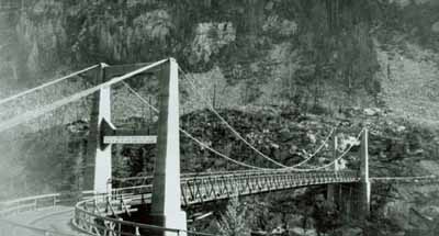
The Doukhobor Suspension Bridge spans the Kootenay River a short distance upstream from its confluence with the Columbia River. Built as a community effort, the structure is comprised of reinforced concrete towers that rise to a height of 14.6 metres (48 feet) and rest on concrete piers embedded in the rock face on opposite banks of the river. The two towers support four steel wire cables that are attached at both ends to steel sockets anchored in the rock face. The bridge deck linking the towers is 100.9 metres (331 feet) in length and is suspended from the overhead cables by vertical steel rods. The deck frame is constructed of structural steel covered by wooden planks, stringers and surface decking. The wood decking is now badly deteriorated, and approach ramps to the bridge have been removed to prevent access. Official recognition refers to the bridge structure and its footings.
National Historic Site. The Doukhobor Suspension Bridge was designated a national historic site in 1995 because: it was built by, and is closely associated with, the Doukhobours who were engaged in a significant effort in the first half of the 20th century to build a Christian utopian community in western Canada; the bridge ranks as a symbol of Doukhobour culture and is one of the few remaining built resources connected with this cultural group in the period before the Second World War; and its construction almost entirely by Doukhobour settlers was a major accomplishment for a pioneer community and demonstrated the considerable capabilities of a people acting communally.
The Doukhobor Suspension Bridge provided a vital road link between the Doukhorbor communities of Brilliant and Ootenshenie on opposite sides of the Kootenay River. Its construction was undertaken by members of this utopian community who volunteered their labour at the behest of their leader, Peter Vasilevich Verigin. Using traditional hand labour techniques, the workers undertook the challenging tasks of forming and pouring the piers and towers in the recently introduced medium of reinforced concrete, then assembling and installing the massive cables and steel decking. Begun in April 1913 and completed just 8 months later, the Doukhobor Suspension Bridge was largely financed by the Doukhobor community and played an important role in the cultural and economic growth of this distinctive self-supporting communal society and of the West Kootenay region for over 50 years.
Restoration. The Brilliant Suspension Bridge was built by the local Doukhobor community in 1913 and was used until 1966, when a new highway bridge was constructed over the Kootenay River. Public outcry saved the historic bridge from demolition in the 1970’s and in 1991 a Working Group was formed to explore the possibility of restoring the bridge. After years of perseverance by some members of the community, the bridge was declared a National Historic Site of Canada in 1995. Years of fundraising led to the start of restoration and with the tremendous support of sponsors, financial partners and the diligence of the restoration committee and volunteers the dream was brought to fruition. The bridge was opened to foot traffic at the official Grand Re-Opening Celebration on May 22nd, 2010. The Brilliant Suspension Bridge is the main attraction of the Brilliant Bridge Regional Park, which also includes an observation platform, and is included in the Trans Canada Trail.
