
COLUMBIA & WESTERN RAIL TRAIL – Castlegar to Midway 164 km
HISTORY
Rossland/Trail to Castlegar. Constructed in 1896, its route connected silver and gold mines at Red Mountain and Rossland and a smelter at Trail. Augustus Heinze was the force behind the line, as he was also the developer behind the Trail Smelter and worked quickly to gain a competitive advantage before the construction of the Canadian Pacific Railway into the Kootenay region.
Initially, it was a 3 ft (914 mm) narrow gauge line, and the steep, 3,400-foot (1,036 m) rise of the mountain from the Columbia River necessitated the use of three Shay locomotives to move the open ore cars, past the fruit trees of Warfield, and onto the LeRoi and War Eagle mines.
Rossland Railroad Grades. Trails with a moderate grade for walking, jogging and snowshoeing exist on the abandoned CPR grade. The original CPR grade can be followed from Union St, just below Spokane Avenue in Rossland, 7.1 km to Warfield (elevation loss 330m 1080′), where it ends near the municipal works yard. Coordinate with the bus for a ride back to Rossland. The bus has racks for bikes.
The CPR railway grade stops at Union Avenue now. However, years ago, it used to wind through south Rossland, just below Columbia Avenue, around to Butte Street, and into the station (no longer there) on Second Avenue, between Washington and Monte Cristo Streets.
Painted on the rock faces on the CPR grade near Rossland are old hotel names and other advertisements from another era, as well as reminders of the area’s colourful history.
A spur ran to the Arrow Lakes steamer landing at Robson. Heinze was sold to the Canadian Pacific Railway in 1898. The line was regauged to 4 81⁄2 ” (1,435 mm) standard gauge by the CPR in 1899.
Railroad Construction Nelson to Castlegar. Railroad construction on the Boundary Subdivision began in 1890 when the Canadian Pacific Railway (CPR) chartered the Columbia and Kootenay Railway and Navigation Company (C&K). The C&K started building from Sproats Landing (across the Columbia River from present-day Castlegar) and was the first segment of what became the Southern mainline. Completion of this line provided transportation of ore from Nelson north on paddle wheelers over the Arrow Lakes and Columbia River to the CPR mainline at Revelstoke. A short extension of the C&K from Sproats Landing to Robson allowed for the construction of a rail barge slip. Robson became the terminus of the active C&K railway. Barges at first joined the C&K and C&W railways between Robson and West Robson. The Bridge across the Columbia River was completed in 1902, completing the last link in a continuous rail line between Nelson and Midway. This line was renamed the Boundary Subdivision in 1910. Grade revisions were made in the early 1940s and late 1960s to accommodate the construction of the dams at Brilliant and Labarthe (Hugh L Keenleyside Dam).
After the CPR had a standard gauge portage railway running from Nelson to Robson in 1891, they embarked on a massive expansion. This expansion included placing a line over the Crowsnest Pass to Creston, which indirectly connected to Nelson, and then to the portage railway down the Kootenay River. The fundamental basis for all of this was to move coal from Fernie to the smelter at Trail, in connection with shifting the ore down Red Mountain and sending the final reduced concentrates out to the Eastern US. The purchase of the C and W lines allowed for the continued westward expansion of a standard-gauge line. This was done by 1900, running a link via Brooklyn, Gladstone and Paulson to Grand Forks.
A wooden railway bridge, crossing the large Columbia River, was built in 1902 at Robson to the new town of Castlegar on the west bank. Thus, by this time, the Kettle Valley Railway and the Columbia and Western Railway were physically joined to the central Canadian Pacific system via Princeton, Brookmere, Merritt and Spences Bridge. The Coquihalla Pass line to Hope was finished in 1916. Again, the Canadian Pacific had extensive fleets of lake steamers and tugs on the Okanagan, Arrow, Slocan and Kootenay Lakes.
Railway Construction Castlegar to Midway. In 1890, gold and copper were discovered near Rossland. The Columbia and Western Railway (C&W) was chartered to run from the smelter in Trail to Penticton. This line was completed to Robson West in 1897. The C&W from Rossland to Trail was a narrow-gauge railway to the smelter at Trail. On April 2, 1898, surveyors led by Rice reached Grand Forks with slashing crews following close behind them. By September 24, six railroad construction camps between Cascade and Grand Forks employed 250 men. A portable sawmill, operated by McPherson and Stout, supplied rail ties and timbers, and W.H. Fisher supplied 70,000 rail ties from a site north of Niagara. The Columbia and Western Railway was purchased from mining developer Fritz Heinze, along with the Trail Smelter, by the CPR in 1898.
The Boundary country ore (from the City of Paris Mine) was delivered to the Trail Smelter. On November 25, 1899, passenger service was extended to Greenwood. By 1900, the railroad had reached Midway with a branch line from Eholt to the copper-rich area of Phoenix. Construction of this railroad required great effort and was often extremely dangerous. On January 11, 1900, two men were killed by a flying rock. On February 4, 1900, 100 men were sent out on two shovel drifts. By reaching the Boundary District, the CPR had scored a significant victory against its American railroad competitors in its bid to re-establish Canadian control in southern British Columbia. American communities along the Kettle River and tributary valleys south of the international boundary found it easier to ship via CPR than to use the long and rough wagon roads leading to J.J. Hill’s Great Northern (GN) railroad in Washington State.
Trackage was added to West Midway following the abandonment of the Carmi Subdivision (Kettle River Railway) in 1978.
Branch Line from Grand Forks to Republic. The Kettle River Valley Railway (KRVR) extended its service south from Grand Forks to the copper mining areas of Republic, Washington, in 1902. This line was followed later that year by the Great Northern Vancouver Victoria & Eastern Railway (VV&E) and the Washington & Great Northern Railway (W&GN), which was also built to the Republic. After Great Northern controlled lines connected the Republic with the Granby Smelter, the KRVR lost most of its market to the much larger GN. The fierce rivalry between the U.S. and Canadian railroads included considerable legal maneuvering and occasional skirmishes between construction crews, such as the “Battle of Midway”.
The W&GN and VV&E railways eventually completed an international route through Midway, Bridesville, Oroville, Keremeos, and Princeton to Brookmere. From Brookmere, trackage rights over CPR’s Kettle Valley Railway and Canadian Northern Railway (now Canadian National Railway) formed a route to the Great Northern Fraser Valley network, which terminated at Vancouver. Burlington Northern passenger trains from Spokane began to pass through Grand Forks in 1909. Many of the lines west of Curlew were abandoned during the 1930s, and passenger service on GN between Republic and Grand Forks was discontinued in 1938.
Branch Line from Eholt to Phoenix. Although the vast copper deposits at Phoenix were discovered in 1891, it was not until CPR’s Columbia & Western Railway entered the Boundary District in 1899 that development became feasible. Only with the construction of the Granby Company’s large smelter at Grand Forks and the construction of CPR’s branch into Phoenix could the ore be extracted and refined economically. Phoenix Branch construction began from Eholt on CPR’s Boundary Section in 1899. Many crews were employed to work on this construction. One of these crews, working under J.V. Welsh, consisted of 125 men. The last spike on this branch was driven at Phoenix on May 23, 1900. The Grand Forks Smelter was completed by August of that year, and several spurs were added later to serve other mines. One of these spurs led to the Smelter Lake Dam, the remains of which are visible today.
CPR’s Shay-type geared locomotives were transferred from the Rossland Branch for use on the steep grades of the Phoenix Branch. These engines were withdrawn after a spectacular runaway accident (Dead-man’s Wreck) which destroyed a CPR engine in 1904. By 1905, the VV&E was also operating a line into the mining areas of Phoenix, and GN opened its line later that year. With easier grades than CPR’s Phoenix Branch from Eholt, GN was able to handle heavier trains and soon became the primary carrier of Phoenix ores to the Grand Forks smelter. In 1913, the CPR allowed the KRVR to use its Grand Forks roundhouse in exchange for the CPR’s use of the Kettle River Valley Railway’s downtown station.
Beginnings of a Line North from Grand Forks. In 1904, the Kettle River Valley Railway (KRVR) received permission to build north from Grand Forks on a route projected to run through Vernon to the coal fields of the Nicola area. Construction was slow, and by 1907, the line had stalled at Lynch Creek, only 20 miles north of Cuprum. The following year, negotiations began with the CPR, resulting in a 1910 agreement between the CPR and KRVR charter and in 1911, the name was officially simplified to Kettle Valley Railway (KVR). When the line was leased to the CPR in 1913, the KVR became the seed which allowed the CPR to complete its southern route westward from Midway.
Spur from Greenwood to Mother Lode. A branch line was constructed by the CPR from Greenwood to Deadwood Camp and the Mother Lode Mine in 1900. Also called the Deadwood Spur, the line opened the copper-rich Deadwood Ridge area for mining development—the B.C. Copper Company Smelter was completed in 1901 on the spur above Greenwood and shortly thereafter employed 400 men. The company built a smelter at Grand Forks that, in 1900, was connected to the mines at Phoenix by a branch of the CPR. The first ore was shipped in July of that year, and the smelter blew in on August 21. By 1905, more than 1,995,800 tonnes of ore had been shipped, and the Granby smelter became the largest copper smelter in the British Empire and the second largest in the world. In 1910, most of the ore bodies at Phoenix were under the control of the Granby Company. However, some remained in the hands of the B.C. Copper Company and the New Dominion Copper Company, which shipped ore to their smelters at Greenwood and Boundary Falls.
The Latter Years (The 50’s, 60’s, 70’s, and 80’s)
After the completion of the Kettle Valley Railway linking Midway to Hope through Penticton and Princeton and over the Coquilhalla Pass in 1915, Nelson had become only a day’s travel by passenger train from Vancouver and ten hours from Penticton. Trade and commerce in the Kootenays, which were once dependent upon Great Northern and Spokane in the United States, came under British Columbia’s control. Trade in southern B.C. had all but ceased to flow across the border to the U.S.
Following World War 1, copper prices fell, and the copper mines and the Granby and Greenwood smelters closed. Between 1918 and 1920, every copper smelter in the Boundary District closed down, effectively destroying CPR’s hopes that Boundary copper traffic would be redirected to Vancouver on their Kettle Valley Railway. The Phoenix spur from Eholt was closed in 1919 and abandoned in 1921. The Mother Lode spur from Greenwood was abandoned in 1919.
Daily passenger service, which included eastbound Train #11 (Kootenay Express) and westbound Train #12 (Kettle Valley Express), was continued throughout most of the railroad’s operating history. After the war, the railroad also experienced an increase in local freight traffic. The three biggest local traffic commodities during the post-war years were coal, lumber and fruit. When the highways and airlines stripped the KVR of its passenger trade and its lucrative freight traffic, the railway’s steep grades became uncompetitive relative to the lesser grades of CPR’s mainline. Another factor leading to the demise of the KVR was the opening of the Hope-Princeton highway in 1951. The remaining bulk commodity traffic required longer and heavier trains.
Although the KVR produced an operating profit for most of its years, the railway never came close to paying off the massive capital investment of its rugged construction. Nevertheless, the KVR halted the flow of Kootenay trade to the United States at a critical time in B.C.’s history and thus provided an essential contribution to the development of the Province.
Freight service on the KVR was terminated shortly after abandonment of the Coquihalla line in July 1961, and due to major devastation by avalanches the previous winter. The line was abandoned after serving for nearly 50 years. The extensive bridges of this line quickly succumbed to the forces of nature and the demolition practices of the Canadian Army. Some of the smaller bridges that crossed narrow creeks were sold for scrap. Most of the resident buildings, station platforms and other right-of-way buildings were torn down or set ablaze. Rolling stock was removed, followed by rails and ties. The 131 miles of trackage between Penticton and Midway were abandoned in 1978. This portion is now part of the Trans Canada Trail network in southern B.C. Rails were removed between Midway and Castlegar in 1990.
Today, Burlington Northern continues to provide rail service to Pope & Talbot (now Interfor) sawmill for a little longer, as they too are struggling along. The section in the industrial area between the two bridges in Grand Forks was purchased from CPR in 1992 by Pope & Talbot and CanPar Industries, which operate it as a private railway. This section of the railroad has remained in active use. A bypass trail routes you to the town of Grand Forks and connects you back to the Columbia and Western. The entire railway, including the Kettle Valley Railway, is now part of the Spirit of 2010 Trail and Trans-Canada Trail systems in British Columbia.
COLUMBIA & WESTERN RAIL TRAIL – Castlegar to Midway 164 km
Travels the abandoned Canadian Pacific Boundary Subdivision with the last train going through in 1991. In 2000, the C.P.R. donated the line to the Province of British Columbia for a Recreational trail to form British Columbia’s Trans-Canada Trail network.
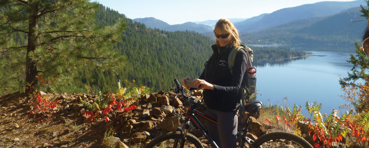
CASTLEGAR to PAULSON STATION – 60km. The official starting point is the old Castlegar Train station. Many park 8.8km away at the end of Arrow Lakes Drive. There is an official trail marker there, and plenty of parking is available.
Castlegar to Christina Lake is nice, with hard-packed gravel and a steady but easy uphill that crests around 51km, before heading back down to the Paulson Station wilderness campsite, a good first-night campsite.
Km 0.0 Castlegar Station. Castlegar had a 44-car siding, wye, 142-car yard, and station building. Castlegar station is located at the junction with CPR’s Rossland Subdivision to Trail. Once with a coal tower and water tank, all that remains today is a two-story depot built in 1907, a heritage building and a railway museum. Present-day train activity in Castlegar is limited to through freight traffic to and from the Trail Smelter.
Km 2.6 Robson West Station. Robson West was the terminus of Heinze’s C&W from Trail. Barges would ferry the train up Lower Arrow Lake to connect to the CPR. The CPR had a dock here to service passengers and freight from Paddle wheelers that worked the Arrow Lakes. It consisted of a 67-car siding. Robson West remained a CPR lake steamer port and barge slip until the last run of the SS Minto in the mid-1950s. Other than a few remaining pilings, not much remains of Robson West.
Labarthe Station. Former siding near the start of the westward grade to the summit and the site of a turntable for turning helper locomotives.
Km 21.5 Shields Station. Site of a former passenger train flag stop and steam locomotive water stop. A large open area is all that is left.
Km 28.7 Coykendahl Station. 63-car siding, station, and steam locomotive water tank. A Tuscan red shed built into the side of the hill and a Railway Speeder are all that remain. Possibly the best views of the entire KVR/C&W system down to Arrow Lakes just before it turns south towards the tunnel and Christina Lake.
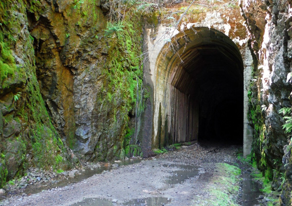
Bulldog Tunnel. At 912m, it is the longest tunnel in the BC rail trail system. Not only is it long, but it is curved, so as you head west, there is no “light at the end of the tunnel” for most of the way.
Km 39.7 Tunnel Station. 13 car storage track, station and water tank at the west end of the 971m long Bull-Dog Tunnel. Station foundation and an apple tree overlooking Dog Creek Valley. This is an excellent campsite with a new picnic shelter, outhouse, tent site, and picnic table.
Km 51.6 Farron Station. The summit station of the Monashee Mountains is a turning point for helper locomotives. All the buildings have disappeared, but the foundations remain; the most prominent is the concrete diesel cistern along the rail bed.
Memorial to Doukhobor leader Peter V. Verigin, who was killed in one of the earliest terrorist attacks in Canada, a still-unsolved Canadian Pacific Railway train explosion on October 29, 1924, near Farron.


Km 59.3 Paulson Station. The Paulson Brothers established a hotel, store and stables. A siding was added at KM 57.3 to service ore shipments from the Bonanza mine. Log foundations and the remains of other buildings can be seen along the banks of McRae Creek.
PAULSON STATION to EHOLT STATION – 74km
Steady downhill to Christina Lake, with restaurants and accommodation options. At the first intersection between the Columbia & Western and the Crowsnest Highway (BC 3), an option is to get back onto the pavement, much of the paved route is downhill too. Go from 18 kph in the loose gravel of the trail to 45-50 on the highway.
After a day and a half of biking 60 km of trail from Castlegar to Paulson, the 50 km to Grand Forks on the highway may take only a couple of hours.
Km 73.2 Christina Flag Stop
Km 76.8 Fife Station. 17-car storage track, passenger flag stop and steam locomotive water stop. Fife is the location of a large lime quarry.
Km 82.8 Billings Station. Flag stop and site of the Yale-Columbia Sawmill. Small cemetery across the highway.
Km 86.9 Gilpin Station. Former siding and flag stop, across the Kettle River and visible are the residences of the Sons of Freedom Sect. A swing bridge was removed in the early 1980s.
Km 93.3 Cuprum. The former junction and wye are named for copper. Canadian Pacific’s passenger trains detoured over the Kettle Valley Railway between Cuprum and West End until 1921, when KRVR’s bridge was damaged and trains were backed one way to the “City Station” from West End. Cuprum was the site of a former race track and fairgrounds known as Dinsmore Park.
Km 94.8 Grand Forks Station. 59-car siding plus a 194-car yard and station building. Located west and north of the center of Grand Forks, CPR’s C&W station was not used as the main passenger depot for the city between 1913 and 1952. Instead, CPR passenger trains used the Kettle River Valley Railway’s downtown “City Station”, which is now gone.
Could camp at the Grand Forks Municipal Campground
Km 95.3, KM West End Station or City Junction. Former junction with the old Kettle River Valley Express line over which CPR passenger trains reached the old (former KRVR) “City Station”. This station was located in what was the separately incorporated City of Columbia, which later amalgamated with the City of Grand Forks on December 30, 1902. CPR located the station in Columbia because the City of Grand Forks would not allow even CPR employees to enter the city. Most residents of Grand Forks did not like CPR in those days. Only by acquiring the KRVP did the CPR manage to get a foothold within the Municipality.
The trail gets ugly as it becomes thoroughly chewed up from ATVs and dirt bikes, making it a struggle, even with the manageable uphill grade.
Km 96.4 Granby Station. Passenger flag stops at the junction from which CPR’s 3.5 kilometres (2.2 miles) Granby Smelter Spur climbed to the Granby Consolidated Mining Company’s copper smelter. The smelter was once the largest copper smelter in B.C. Today, the smelter site is surrounded by giant slag piles. The slag is being utilized for roofing granules and as an abrasive for sand-blasting ships. Pacific Abrasives holds rights to the slag piles, which the City of Grand Forks owns.
Km 100.3 Fisherman Station. Former siding and steam locomotive water stop. This station was named Niagara until 1900, after which the name was given to the nearby Kettle River Valley Railway station. Around the turn of the century, Niagara was a wild, open boom town. Several bake ovens built by Italian railway cooks remain near the Lime Creek crossing on the flat site of Neil Hardy’s Lime Creek Hotel. Seven miles of rock work were required to construct the nearby section of the railroad.
Willgress Lake Campsite is about 30km uphill from Grand Forks.
Km 108.8 Eholt Station. Junction with CPR’s branch line into the copper mining area of Phoenix. The station building, an eight-stall engine house, a coal tower, a water tank, and a substantial support community. The Eholt wye, which had formed the junction with the Phoenix line, remained into the late 1970s.
EHOLT to MIDWAY – 30km
There are sections from here that are unused, with thick, long grass covering the trail as it winds through pastures and fields toward the town of Greenwood.
Just before Greenwood, maybe a locked cattle gate with horses and what appeared to be somebody’s farm. This has been an ongoing issue with no sign of resolution. Ride through the horse field to the exit gate and the public section of the trail.
Km 117.3 Greenwood Junction. Joined CPR’s abandoned Mother Lode Subdivision. Greenwood Station. Water tank and substantial depot. The station burned down after a 1964 train wreck. This railway city, which was incorporated in 1897, lost its status as a timetable station in 1983 when the siding was removed.
From Greenwood, the trail maintains an easy downhill grade into the village of Midway and the Midway Municipal Campground (showers, nearby grocery store, swim in the river that runs just behind the campground).
Midway Station. Small yard and depot. Divisional station between CPR’s Columbia and Western and Kettle Valley railways. Following the abandonment of the KVR to Penticton in 1978, the station served as the western terminus of CPR’s southern route. The Crow’s Nest Pass and Boundary Subdivision yard limits were extended to include trackage 3.9 km (2.4 miles) west of Midway station to service Pope and Talbot’s Midway (Interfor 2010) sawmill. The 1909 heritage depot has been restored, designated a heritage building, and is presently used as a railway museum. A second building is a visitor information center and local gift shop.
End of Columbia & Western Railway Mile 127.2. Kettle Valley trackage began here at 1.0 kilometre (mile 0.6) of the former Carmi Subdivision.
Present Status of the The Columbia Western Rail Trail (CWRT)
The CWRT stretches from Castlegar to Midway. It was originally a railroad that was operated by the Canadian Pacific Railroad (CPR). It was acquired by the Trans Canada Trail Foundation from CPR in 1993 and donated to the Province of BC in 2004. The trail at the time, was managed by Tourism BC.
In 2010, the trail was designated as a Recreational Trail under the Forest and Range
Practices Act and was managed by Recreation Sites and Trails Branch (RST).
On July 3, 2020, a Ministerial Order M322 was signed that removed a 67 km section of the CWRT from the established recreation site. The section that was removed was from the Castlegar terminus of the CWRT to just north of Christina Lake. The reason for disestablishing this portion of the trail was attributed to the route’s challenging terrain; multiple competing users; and the complex infrastructure.
After this portion of the CWRT was disestablished, it became a non-status rail grade on
crown land. At this time, there is no preventative maintenance being conducted on the
CWRT and there is no funding available for maintenance of the rail grade. The rail grade is currently being managed to a wilderness status. The Selkirk Resource District engineering staff will respond to reports of issues on the rail grade if there is an immediate environmental or safety issue that requires mitigation.
This summer the Province will be installing signage along the rail grade at entrance points to the, and at locations that require notification to users due to safety concerns: trestles, tunnels and rock fall hazard.
Ministry of Forests Selkirk Resource District
Mailing Address: 1907 Ridgewood Road, Nelson, BC V1L 6K1.
Tel: 250 825-1100. Website: www.gov.bc.ca/for
If you have any questions, please contact [email protected]
