
TEXAS NORTHEAST (Dallas, Fort Worth, Austin)
There was a big change in weather as I approached Dallas – from -8°C 2 nights previously to +20°C. Leaves were on trees and wild flowers were growing in the ditches.
Dallas major roads are tolled by a tag system. It is an impressive variety of extreme freeways – three tiers, amazing webs of roads converging on some areas.
PLANO (pop 360,000). Located approximately 20 miles (32.2 km) north of downtown Dallas, the city of Plano is a part of the Dallas-Fort Worth metropolitan area. The city is a hub for many corporate headquarters. Plano was also considered to be the safest city in the nation by Forbes in 2011.
Cockroach Hall of Fame. In the NM “Bizzarium” series, until 2012, Plano was home to a unique attraction: the Cockroach Hall of Fame Museum.
“It is not the Smithsonian,” as owner Michael Bohdan liked to say – but it was an interesting enough oddity to merit appearances on “The Tonight Show” and “The View,” as well as mentions on websites like Atlas Obscura and Roadside America. You had to know where to look for it. The museum was part of the Pest Shop, a small do-it-yourself shop that sold extermination products for getting rid of pests in your home – ants, mice, roaches, rats and more. (The shop is still located at the corner of Custer and 15th Street, under new ownership.)
When the museum was open, visitors were treated to exhibits like the Bates Roach Motel office, which featured a roach dressed in a housecoat and wig that moved along a track from the office to Room 1 with a tiny knife in its hand, and a collection of “celebrity” roaches with names like Elvis, David Letterroach, Elvis, Marilyn Monroach and Liberoachi.
Michael is an expert on cockroaches and other critters. He earned a bachelor’s degree in zoology from Southern Illinois University at Carbondale. When the museum was open, Michael enjoyed greeting thousands of visitors each year and answering questions, always sporting his green felt fedora dotted with the carcasses of 14 cockroaches. He still calls himself “Cockroach Dundee.” The Cockroach Museum was a hidden treasure that many Plano residents didn’t know about. The Pest Shop is still open and still helping customers who want to get rid of bugs in their homes. But alas, the Cockroach Hall of Fame Museum is no more. Michael Bohdan moved to Phoenix to retire but returned to Dallas a few years ago. He still has his cockroaches and hopes one day he can find a new home to display them. “Most of the dressed-up cockroaches are still in their cases, stored in boxes,” he said. “It’s a shame that we had to close. I always thought my museum would have legs. It helped educate a lot of people and changed their perceptions about cockroaches.”
DALLAS/ FORT WORTH
Dallas is the largest inland metropolitan area in the U.S. that lacks any navigable link to the sea. It is the most populous city in the Dallas–Fort Worth metroplex, the fourth-largest metropolitan area in the country at 7.5 million people, the largest metropolitan area in the Southern United States.Dallas and nearby Fort Worth were initially developed due to the construction of major railroad lines through the area allowing access to cotton, cattle and later oil in North and East Texas. The construction of the Interstate Highway System reinforced Dallas’s prominence as a transportation hub, with four major interstate highways converging in the city and a fifth interstate loop around it. The Dallas/Fort Worth International Airport is one of the largest and busiest airports in the world
DALLAS (pop 1,345,076) is the ninth most-populous city in the U.S. and third in Texas after Houston and San Antonio.
Dominant sectors of its diverse economy include defense, financial services, information technology, telecommunications, and transportation. Dallas is home to 9 Fortune 500 companies within the city limits. The Dallas–Fort Worth metroplex hosts additional Fortune 500 companies, including American Airlines (Fort Worth) and ExxonMobil (Irving). Over 41 colleges and universities are located within its metropolitan area, which is the most of any metropolitan area in Texas. The city has a population from a myriad of ethnic and religious backgrounds and one of the largest LGBT communities in the U.S. WalletHub named Dallas the fifth most-diverse city in the U.S. in 2018.
Mustangs at Las Colinas is a bronze sculpture by Robert Glen, that decorates Williams Square in Las Colinas in Irving, Texas. The sculpture commemorates the wild mustangs that were historically important inhabitants of much of Texas. It portrays a group at 1.5 times life size, running through a watercourse, with fountains giving the effect of water splashed by the animals’ hooves. The 7 horses and 2 colts have great motion with one horse pausing at the edge of the pool and one balancing on one leg. The horses are intended to represent the drive, initiative and unfettered lifestyle that were fundamental to the state in its pioneer days. Installed in 1984 with a shallow watercourse extending 400 feet (130 m) from northeast to southwest across Williams Square, a gently sloping granite-paved open space about 300 feet (110 m) square.
The buildings around the square rise 358 feet (26 floors) on the north and 217 feet (14 floors) on the east and west sides, with the south side open to O’Connor Boulevard. The sculpture is substantial, but the scale of the surrounding structures keeps it from dominating the space.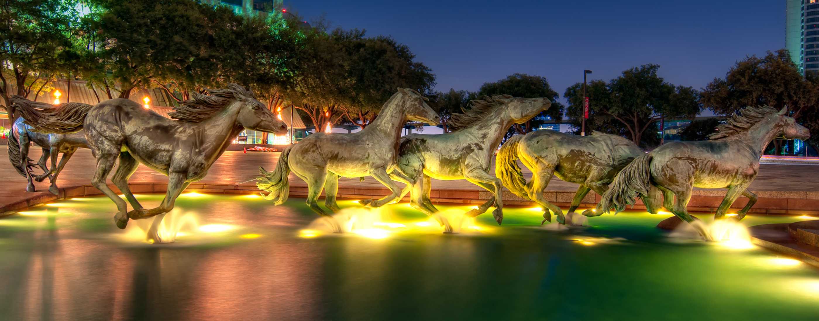
Chapel of Thanksgiving. Thanksgiving Square is a private park and public facility anchoring the Thanksgiving Commercial Center district of downtown Dallas. Dedicated in 1976, the complex consists of three components: a landscaped garden and non-denominational chapel building, a major section of the underground pedestrian network, and the Bullington Truck Terminal. It welcomes people of all cultures and religions are welcome to celebrate values, thoughts, and spirituality in a contemplative setting.
The Square is set fifteen feet below ground level with a four-foot wall blocking the sight of automobiles to create a serene, green island. Water plays a prominent role in the landscape, with active fountains masking city noise. Overt Religious symbolism is intentionally absent from the decoration with quotes and messages as delineated by Hindu, Jewish, Christian and Muslim authorities. Mosaic, stained glass, engraving, and graphic art adorn the walls and windows throughout Thanks-Giving Square.
Chapel of Thanksgiving is the spiritual center open to visitors of all faiths. The spiraling shape rises 90 feet (27.5 m) above street level, suggesting the infinite upward reach of the human spirit. The Chapel’s design takes its inspiration from the Great Mosque in Samarra, Iraq. The entrance to the chapel is at the end of a 125-foot (38 m) bridge that runs over a cascading waterfall. The chapel ceiling contains the stained glass “Glory Window”, one of largest horizontally mounted stained-glass pieces in the world. The 73 panels of faceted glass were designed by Gabriel Loire of Chartres, France featuring warmer and brighter colors as the spiral reaches its apex in the center. Above the entry door is the etched glass window “The Spirit of Thanksgiving,” designed by glass engraver John Hutton.

The Adolphus Hotel. In both the NM “Hospitality Legends” and “Modern Architecture Buildings” series, it is an upscale hotel and Dallas Landmark in the Main Street District. It was for several years the tallest building in the state. Today, the hotel is part of Marriott Hotel’s Autograph Collection.
It opened on October 5, 1912, built by the founder of the Anheuser-Busch company, Adolphus Busch in a Beaux Arts style. From 1922–1946, the hotel grew to national prominence. With 22 floors standing a total of 312 feet (95 m), the building was the tallest building in Texas until it was dwarfed by the Magnolia Petroleum Building (now the Magnolia Hotel) just down the street in August 1922. The building underwent a series of expansions, first in 1916, then 1926 and finally in 1950, at the time giving the hotel a total of 1,200 rooms.
The Adolphus Hotel was featured in Victor H. Green’s Negro Motorist Green Book in 1936. Green published his Green Book, as it is commonly known, as a guide for blacks seeking recreation, and as a road map for black travelers to avoid fatal encounters with whites during the Jim Crow era. Effectively, the Green Book informed blacks not only where they should visit ― which hotels and restaurants and hair salons ― but quite literally where they should not go if they valued their lives. In the early 20th century, the Adolphus Hotel was a resting place for the Ku Klux Klan, which routinely terrorized blacks in the area. The hotel also enforced segregation through the 1950s.
The Adolphus has been the host of many respected leaders of business, government and entertainment, including presidents, from Warren G. Harding to George H. W. Bush. Elizabeth II and Prince Philip also stayed at the hotel in 1991. Acclaimed British Milliner Nick Smith resided at the hotel for several months in 2007 to write his début novel “Rock Royalty: Diary of a Supermodel”. This hotel was a Dallas hub for entertainment and provided a platform that helped developing careers, such as Bob Hope, Jack Benny and others. North American Aviation (P-51 Mustangs, World War II) and others benefitted from its position as a Texas business hub. During the 1980s, the Adolphus underwent a US$80 million renovation, enlarging and modernizing the already-luxurious guest rooms, shrinking the total number to 428 to make the rooms more spacious. The Hotel has been named one of the top ten in the United States by Condé Nast Traveler and also receives high ratings from Zagat, Fodor’s and Frommer’s.
The hotel is reportedly haunted by the ghost of a jilted bride, who has been seen wandering the 19th floor. She was due to be married one day during the 1930s, but her fiancé didn’t show, leaving the bride-to-be embarrassed and broken-hearted. Later that day her body was found, hanging a few feet from the spot where she was due to say her vows.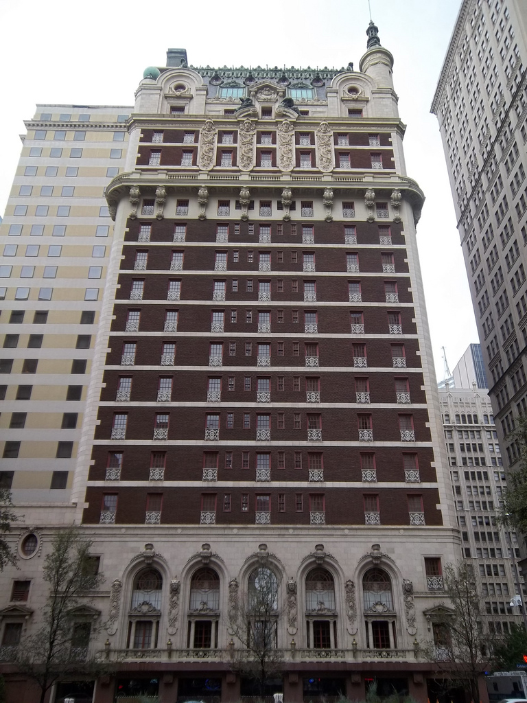
 Ronald Kirk Pedestrian Bridge is a pedestrian footbridge over the Trinity River in Dallas that connects Downtown Dallas and West Dallas, paralleling the 2012 Margaret Hunt Hill Bridge for vehicles, and the 1930 Texas and Pacific Railway Trinity River Bridge
Constructed as the Lamar-McKinney Viaduct in 1933, the original road bridge was built to carry vehicles across the periodically swelling Trinity River to West Dallas. It was completed 27 years after the river’s 1908 flood that submerged most of the area.
The bridge was renamed the Ronald Kirk Bridge in 2016 from its former name, the Continental Avenue Bridge in honour of the first African-American mayor of Dallas, Ronald Kirk.
During the reconstruction of the bridge in 2010, it was decided that there was no need for it to carry vehicular traffic, since the nearby Margaret Hunt Hill Bridge was completed in 2012 to do so. The design as a footbridge complemented the nearby open park plan for Klyde Warren Park, as a recreation amenity. It reopened in 2014 with a playground, a splash park, lounge chairs, human-sized chess boards, and a ceiling of cloth to shade the area, along with many trails surrounding the bridge in the Trinity River Basin and on the levees. 

WACO (140,000).In central Texas along the Brazos River and I-35, halfway between Dallas and Austin.
Waco siege was the siege of a compound belonging to the religious sect Branch Davidians, carried out by American federal and Texas state law enforcement, as well as the U.S. military, between February 28 and April 19, 1993. The Branch Davidians were led by David Koresh and were headquartered at Mount Carmel Center ranch in the community of Axtell, Texas, 13 miles (21 kms) east-northeast of Waco. Suspecting the group of stockpiling illegal weapons, the Bureau of Alcohol, Tobacco, and Firearms (ATF) obtained a search warrant for the compound and arrest warrants for Koresh and a select few of the group’s members.
The incident began when the ATF attempted to raid the ranch. An intense gun battle erupted, resulting in the deaths of four government agents and six Branch Davidians. Upon the ATF’s failure to raid the compound, a siege lasting 51 days was initiated by the Federal Bureau of Investigation (FBI). Eventually, the FBI launched an assault and initiated a tear gas attack in an attempt to force the Branch Davidians out of the ranch. During the attack, a fire engulfed Mount Carmel Center. This resulted in the deaths of 76 Branch Davidians, including 20 children, two pregnant women and David Koresh.
The events of the siege and attack are disputed by various sources. A particular controversy ensued over the origin of the fire; an internal Justice Department investigation concluded in 2000 that incendiary tear gas canisters were used by the FBI, but maintained that sect members had started the fire. The events thirteen miles from Waco, and the law enforcement siege at Ruby Ridge less than twelve months earlier, have been cited by commentators as catalysts for the Oklahoma City bombing by Timothy McVeigh and Terry Nichols.
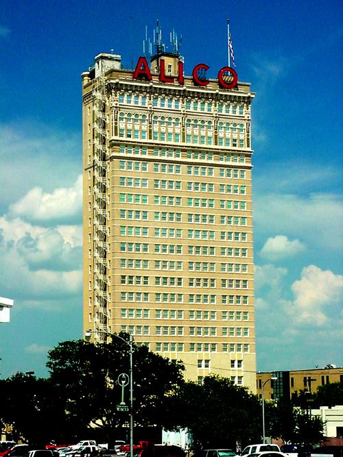
ALICO Building. In the NM “Modern Architecture Buildings, it is a 22-story office building in downtown Waco and is currently owned and operated by the American-Amicable Life Insurance Company of Texas (a subsidiary of Industrial Alliance). At 282 feet tall, it is currently the tallest building located in Waco.
It was built in 1911 at a cost of $755,000 ($19,730,407 adjusted to 2017 dollars), and was completed in one year. It is the second oldest skyscraper built in Texas, after the Praetorian Building in Dallas, built in the previous year.
The ALICO Building was not heavily damaged by the 1953 Waco tornado outbreak, unlike many buildings in downtown Waco. It swayed several feet when directly hit by a tornado, although the building escaped severe damage or collapse. In 1966, the building underwent renovations, including the addition of the large neon sign at the top of the building displaying the acronym “ALICO”.
In 1982, the ALICO building was designated a historical landmark by the Texas Historical Commission. In 2012, it was added to the National Register of Historic Places as part of the Waco Downtown Historic District.
 |
Waco Suspension Bridge crosses the Brazos River. It is a single-span suspension bridge with a main span of 475 feet (145 m). Opened in 1870, it contains nearly 3 million bricks. It is located north of Downtown Waco, connecting Indian Spring Park (on the southwest side of the river) with Doris D. Miller Park (on the northeast side of the river). Every year on Independence Day, the bridge serves as a place where thousands of locals gather to watch fireworks. Indian Spring Park marks the location of the origin of the town of Waco, where the Huaco Indians had settled on the bank of the river, at the location of an icy cold spring.
Before 1869, crossing the Brazos River was a time-consuming and sometimes dangerous ordeal. The only way to cross the river was via ferry, and due to the location of Waco on the growing Chisholm Trail, local businessmen knew that a bridge was needed to support commerce.
The logistical and engineering difficulties he encountered were abnormal because of the remote location. Due to lack of machine shops in the Waco area, getting the materials to the building site was a journey in itself. The nearest railroad was 100 miles (160 km) away, and the closest town with artisans with the skills needed was Galveston, over 212 miles (341 km) from the build site. Supplies were loaded onto a steamer in Galveston, and ferried to Bryan. From there, they were loaded onto wagons pulled by oxen. The pothole-filled dirt road from Bryan to Waco was bad, even by 19th century Texas standards.
The twin double-towers that anchored the span were considered to be a marvel of engineering at the time, containing nearly 3 million bricks, which were produced locally. The bridge collected its first toll on January 1, 1870. Its 475-foot (145 m) span made it the first major suspension bridge in Texas.
The bridge was wide enough for stagecoaches to pass each other, or for cattle to cross one side of the bridge, and humans to cross the other side. Being the only bridge to cross the Brazos at the time, the cost of building the bridge, which was estimated to be $141,000 was quickly paid back. Tolls were 5 cents per head of cattle that crossed, along with a charge for pedestrian traffic.
In 1889, the bridge was sold to McLennan County, which removed all tolls. In 1913-1914, major reconstruction occurred on the bridge, replacing the older steel with higher gauge, and trusses were added to accommodate the span to carry heavier weights. This doubled as a new pedestrian walkway.
By 1971, the bridge had seen over 100 years of traffic. What started out as a Cattle Bridge had become a vehicular bridge, and the state historical committee decided that it was time to be retired, with larger and arguably safer bridges being built since the inception of the Waco Suspension Bridge. The bridge, by all accounts, helped to transform Waco from a small frontier town to a major commercial center. Today, the bridge is open to foot traffic only, and is on the National Register of Historic Places. On the south side of the bridge is sculpture of 39 longhorns and 3 riders running across the small park.
AUSTIN/ROUND ROCK (Greater Austin) (pop 2.2 million)
This is a five-county metropolitan area in Central Texas on the eastern edge of the American Southwest, and borders Greater San Antonio to the south.
The metropolitan area is centered on the City of Austin—the fourth-largest city in Texas and the 11th-largest city in the United States with a population of 950,715 people.
Greater Austin has a diverse economy heavily anchored by government activities and education. High-tech firms, particularly related to semiconductors and software, are also important economic pillars. Most of the area’s largest employers are all within the City of Austin including the Texas Government, the United States Government, and the University of Texas at Austin. Major employers outside of Austin include Dell (Round Rock), MD/Totco in Cedar Park (a division of National Oilwell Varco), Southwestern University in Georgetown, and Texas State University in San Marcos.
Major area universities include the University of Texas at Austin (flagship of the University of Texas System), Texas State University, and Southwestern University (Georgetown). The city of Austin itself contains numerous other institutions of higher education including Austin Presbyterian Theological Seminary, Concordia University, Houston-Tillotson University, St. Edward’s University, and others.
In 2010, 43.3% of adults in the City of Austin held college degrees, placing fourth among the 77 largest cities in the U.S.
The communities in Greater Austin hold many annual events. In Austin two of the most well known festivals are the South by Southwest Music and Film Festival (mid March) and the Austin City Limits Music Festival, which draw artists and spectators from around the world.
Austin has adopted the nickname “Live Music Capital of the World” based on its claim of having the highest percentage of music performers of any other major city. The city has a variety of venues for live music performance of popular and country music including famous clubs such as Antone’s and Emo’s. The long-running television program Austin City Limits has for decades showcased the city’s music scene, as has the South by Southwest festival and other events in the city.
Pfluger Pedestrian Bridge is a shared use bridge for pedestrians and cyclists spanning Lady Bird Lake in downtown Austin, Texas. Opened in 2001, the bridge connects the north and south sides of the Ann and Roy Butler Hike-and-Bike Trail and features an unusual “double curve” design. The bridge runs parallel to the Lamar Boulevard Bridge, which carries road traffic across the lake roughly 200 feet (61 m) to the west but it offers no dedicated bicycle lanes and only narrow sidewalks separated from the street by low curbs. In 1991, a drunk driver hit and killed a cyclist on the bridge.
It has a “double curve” deck connecting the trails on the north and south shores along natural “paths of travel,” giving the bridge an hourglass shape and curved connectors crossing each other over the lake, intersecting and overlapping to create a wider space in the middle that could serve as a gathering place and look-off point – a bridge with no straight lines. It was opened in 2001, whereupon it was named for James D. Pfluger, a notable Austin-area architect who designed parts of the city’s hike and bike trail system.

Museum of the Weird. In the NM “Bizzarium” series, the dime or dime store museum is by all accounts an endangered species. The first dime museum, “The American Museum,” was opened in 1841 by P. T. Barnum. It represented a departure from high-class art and science museums, catering to a poorer crowd and offering items of a much more dubious nature.
Part of the appeal of the dime store museum lay in arguing about what was real and what was a “humbug,” as P. T. Barnum called a hoax or fake display. Feejee mermaids (a type of fake or “gaff” taxidermy made from a monkey and a fish, sewn together to form an incredibly ugly “mermaid”) mixed with real exotic animals, and scientific instruments sat next to a loom run by a dog. Unfortunately, Barnum’s American Museum burned to the ground in 1865.
Though many dime museums had disappeared by the 1920s, dime museums such as New York City’s Hubert’s Museum would remain open until the late 1960s. One of the best recreation dime museums, Baltimore’s American Dime Museum, opened in 1999 only to shutter its doors in 2007. So though it may not look like much at first, “Austin’s Museum of the Weird” is, in fact, a rare beast.
Created by artist-entrepreneur Steve Busti, the museum lives in the back of his store, the “Lucky Lizard,” and features many of the same types of curios you might have encountered in a turn-of-the-century dime museum, including a feejee mermaid. Among the other items shown are a cyclops pig, a hand of glory (supposedly the dried and pickled hand of a man who has been hanged), a two-headed chicken, shrunken heads, and mummies. Followed by a tour of their very own Wax Museum, then you’ll be ushered into a dark room and shown their special exhibit, “The Minnesota Iceman”, a decades-old mystery.
Lastly, you’ll be shown into a theater (where Johnny Depp once stayed) and given a live sideshow performance. A rotating cast means you’ll see “The Black Scorpion” perform a traditional show, John T. Rex hold a live wire in his bare hands, “The Amazing Face” hurt himself, and a three-legged dog. (Note, performers work for tips.)
Though more expensive than a dime, the Museum of the Weird happily continues the tradition of the dime store museum. $12
Tejano Monument is a memorial commemorating the impact of Tejanos on Texas culture and history, installed on the Texas State Capitol grounds in Austin, The Tejanos were descendants of Spanish explorers and colonizers who entered Texas as early as 1519. In 1650, the first longhorns were released. Built in 2012, it features nine life-size bronze statues on a 275-ton Texas Sunset Red Granite base, and five plaques describing Tejano history.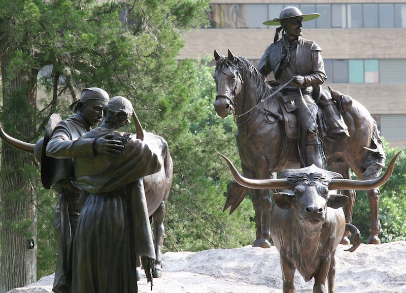
Texarkana. In the NM “XL” series, Texarkana metropolitan is a two-county region anchored by the twin cities of Texarkana, Texas, (population 37,333) and Texarkana, Arkansas, (population 30,259), and encompassing the surrounding communities in Bowie County, Texas, and Miller County, Arkansas. As of the 2016 census, the MSA had a population of 150,098.
Texarkana was founded in 1873 on the junction of two railroads. The name is a portmanteau of TEXas, ARKansas, and nearby LouisiANA.
Texarkana began as a railroad and lumber center, and developed in the 20th century as a regional agricultural processing, retail, wholesale, and service center. Red River Army Depot and Lone Star Army Ammunition Plant were the largest regional employers from the 1940s through the 1970s. Paper mills near Ashdown and Atlanta, as well as other industrial facilities, brought new jobs to the area in the 1970s. Today the Texarkana area is a diversified economy whose pattern of employment categorized by industry is very similar to the entire state of Arkansas.
In 1946, Texarkana was in fear of an unidentified serial killer who attacked eight people, five of whom were murdered. The term “serial killer” wasn’t around yet, but the town knew they were dealing with an unknown killer who was attacking couples on “lovers’ lanes”. The local paper dubbed him “The Phantom Killer”. The attacks became known as the “Texarkana Moonlight Murders” by the news media. Since the killer was never identified or apprehended, the description of the killer came from the only two survivors. They described their attacker as six foot tall with a white mask over his head with holes cut out for his eyes and mouth. He had a pistol and a flashlight. They disagreed on his race. One survivor thought he was a light-skinned African American while the other thought he was a dark-tanned Caucasian man.
NOMAD MANIA Texas Northeast (Dallas, Fort Worth, Austin)
XL: Texarkana (Texas/Arkansas border)
House Museums/Plantations
Bonham: Sam Rayburn House State Historic Site
Denton: Bayless Selby House Museum
Nacogdoches: Nacogdoches Sterne-Hoya Museum
Theme Parks: Florida/Texas/Kentucky: Dinosaur World
Monuments: Las Colinas: Mustangs Statue
Religious Monuments: Ballinger: Ballinger Cross
Railway Museums: Frisco: Museum of the American Railroad
Villages and Small Towns
FREDERICKSBURG
JEFFERSON
SALADO
WIMBERLEY
Museums: Fredericksburg: National Museum of the Pacific War
Cities of the Americas
ABILENE
KILLEEN
LONGVIEW
TYLER
WACO
House Museums/Plantations: Mc Culloch House Museum
Modern Architecture Buildings: ALICO Building
Pedestrian Bridges: Waco Suspension Bridge
ARLINGTON
Museums: International Bowling Museum
House Museums/Plantations: Fielder House Museum
AUSTIN/ROUND ROCK World Cities and Popular Towns
Airports: Austin (AUS)
Museums
Blanton Museum of Art
Bullock Texas State History Museum
Lyndon Baines Johnson Library and Museum
Mexic-Arte Museum
Texas Memorial Museum
Thinkery
House Museums/Plantations: Neill-Cochran House Museum
Festivals
Austin City Limits (Oct 2-20, 2020)
Fun Fun Fun Fest
SXSW (Mar 13-22, 2020)
Cine Las Americas International Film Festival
Entertainment/Things to do: Austin Bouldering Project
Monuments: Tejano Monument
Pedestrian Bridges: Pfluger Pedestrian Bridge
Bizzarium: Museum of the Weird
DALLAS/ FORT WORTH World Cities and Popular Towns
Airports
Dallas – Love Field (DAL)
Dallas/Fort Worth (DFW)
Railway, Metro, Funiculars, Cable Cars: Dallas Area Rapid Transit
Museums
Dallas Museum of Art
George W. Bush Presidential Library
Nasher Sculpture Center
Perot Museum of Nature and Science
Kimbell Art Museum
Modern Art Museum of Fort Worth
Religious Temples: Chapel of Thanksgiving
Modern Architecture Buildings
Dallas: Adolphus Hotel
Fort Worth: Bass Performance Hall
Festivals: Dallas: North Texas Irish Festival
Zoos
Dallas: Dallas Zoo
Fort Worth: Fort Worth Zoo
Botanical Gardens: Arboretum and Botanical Gardens
Aquariums: Dallas: The Dallas World Aquarium
Hospitality Legends: The Adolphus Hotel
Monuments: John F. Kennedy Memorial Plaza
Pedestrian Bridges: Ronald Kirk Pedestrian Bridge
Aviation Museums
CAF Airpower Museum
Frontiers of Flight Museum
The Dark Side
Holocaust and Human Rights Museum (opens Sep 19)
Sixth Floor Museum at Dealey Plaza
PLANO
Museums: Heritage Farmstead Museum
Bizzarium: Cockroach Hall of Fame
WICHITA FALLS
House Museums/Plantations: Kell House Museum
Railway Museums: Wichita Falls Railroad Museum
++++++++++++++++++++++++++++++++++++++++++++++++++++++++++++++
TEXAS SOUTHEAST (Houston, San Antonio, Corpus Christi)
SAN ANTONIO (pop 1.5 million, metropolitan 2,550,960)
San Antonio, from Spanish, “Saint Anthony,” is the seventh-most populous city in the United States, and the second-most populous city in both Texas and the Southern United States, with more than 1.5 million residents. Founded as a Spanish mission and colonial outpost in 1718, the city became the first chartered civil settlement in present-day Texas in 1731. The area was still part of the Spanish Empire, and later the Mexican Republic. It is the state’s oldest municipality, having celebrated its 300th anniversary on May 1, 2018.
The city’s deep history is contrasted with its rapid growth over the past few decades. It was the fastest-growing of the top ten largest cities in the United States from 2000 to 2010, and the second from 1990 to 2000. Straddling the regional divide between South and Central Texas, San Antonio anchors the southwestern corner of an urban megaregion colloquially known as the “Texas Triangle”. The Greater San Antonio and Greater Austin areas are separated from each other by 80 miles along Interstate 35 between which lie the city of New Braunfels.
San Antonio was named by a 1691 Spanish expedition for Saint Anthony of Padua, whose feast day is June 13. The city contains five 18th-century Spanish frontier missions, including The Alamo and San Antonio Missions National Historical Park, which together were designated UNESCO World Heritage sites in 2015. Other notable attractions include the River Walk, the Tower of the Americas, SeaWorld, the Alamo Bowl, and Marriage Island. Commercial entertainment includes Six Flags Fiesta Texas and Morgan’s Wonderland amusement parks. According to the San Antonio Convention and Visitors Bureau, the city is visited by about 32 million tourists a year. It is home to the five-time NBA champion San Antonio Spurs, and hosts the annual San Antonio Stock Show & Rodeo, one of the largest such events in the U.S.
The U.S. Armed Forces have numerous facilities in and around San Antonio; Fort Sam Houston is the only one within the city limits. Lackland Air Force Base, Randolph Air Force Base, Lackland AFB/Kelly Field Annex, Camp Bullis, and Camp Stanley are outside the city limits. Kelly Air Force Base operated out of San Antonio until 2001, when the airfield was transferred to Lackland AFB. The remaining parts of the base were developed as Port San Antonio, an industrial/business park and aerospace complex. San Antonio is home to six Fortune 500 companies and the South Texas Medical Center, the only medical research and care provider in the South Texas region.
SAN ANTONIO MISSIONS
This World Heritage site encompasses a group of five frontier mission complexes situated along a stretch of the San Antonio River basin in southern Texas, as well as a ranch located 37 kilometres to the south. It includes architectural and archaeological structures, farmlands, residencies, churches and granaries, as well as water distribution systems. The complexes were built by Franciscan missionaries in the 18th century and illustrate the Spanish Crown’s efforts to colonize and defend the northern frontier of New Spain, in addition to evangelizing the area’s indigenous population into converts loyal to the Catholic Church.
The missions also included all the components required to establish self-sustaining, socio-economic communities loyal to the Spanish Crown.. The San Antonio Missions are also an example of the interweaving of Spanish and Coahuiltecan cultures, illustrated by a variety of features, including the decorative elements of churches, which combine Catholic symbols with indigenous designs inspired by nature. The Coahuiltecans and other indigenous hunter-gatherers who, in a matter of one generation, became successful settled agriculturists.
Mission Nuestra Señora de la Purísma Concepción de Acuña (Mission Concepción) is located approximately three miles south of downtown San Antonio. The mission was relocated from East Texas to San Antonio in 1731 with the express purpose of converting local Native Americans to Christianity and assimilating them into Spanish society. The location was selected based on its proximity to the San Antonio River, which allowed for irrigated agriculture, and for its location near the presidio at San Antonio, which offered military protection to the mission occupants.
Upon the mission’s foundation, approximately 300 Native Americans were settled on its grant. The Native American settlers were primarily responsible for the construction of structures on the property as well as for improvements to the surrounding agricultural lands, including construction of acequias (irrigation ditches) and initiation of cultivated agriculture. In essence, the mission was a self-sufficient, self-contained village surrounded by irrigated agricultural lands.
The mission faced challenges from its establishment. Many of the converts died of disease, and the facility was regularly threatened with attack by hostile Native American groups unaffiliated with the mission. Church officials had baptized 792 Native Americans and buried 596 in the same year. Twenty years later, there were only 77 Native Americans residing at the mission. Due to the church’s lack of success in achieving their mission and other political factors, the mission was secularized in 1794 with only 38 Native Americans residing there, and the Spanish government divided the mission’s agricultural land between them. The mission compound was abandoned and quickly fell into a state of disrepair.
Restorations occurred in 1861, 1913, in the mid 20th century and in 1978, the mission became part of the San Antonio Missions National Historic Park.
Mission Espada (San Francisco de la Espada) was established in 1731 being relocated from East Texas, where it had originally been established in 1690, to serve members of various Coahuiltican groups residing in the area. Priority was given to establishing an irrigation system and clearing fields for cultivation. The Espada Aqueduct and Acequia were constructed between 1731 and 1745 and are significant for their engineering qualities as portions of the system are still operational today. Permanent building construction followed, including a stone granary and sections of the church building with the Native American residents as the primary labor source.
The first decade was difficult due to the constant threat of Apache raids as well as the rampant disease spreading through the population. In 1737, all the approximately 230 Native American residents abandoned the facility due to the high potential for Apache raids. Some eventually returned only to be further decimated by a smallpox epidemic in 1739. The population of the mission began to stabilize in the 1740s and at its peak period of development in the 1770s, the complex included a church, priests’ quarters, workshops, storage facilities, a friary, and Indian quarters all oriented toward a central plaza.
The period also saw the transition of the mission complex from an open pueblo design to a fortified, walled compound.
The mission was partially secularized in 1794 when most of its agricultural land was subdivided between remaining Indian residents and the growing number of Spanish homesteaders. Full secularization in 1824 marked an extended period of decline. Currently, the complex remains partially in ruins with some reconstructed and restored elements.
The Alamo (Mission San Antonio de Valero) was founded in 1718 and relocated twice to its current and final location. Work on a third church, the one that exists today, began around 1756 but was still not completed before the mission closed in 1793. The complex was subsequently occupied as a military outpost for nearly three quarters of the nineteenth century and they gave the complex its current name.
From 1821-35, soldiers at the Alamo swore allegiance to the new government of Mexico to the start of the Texas Revolution. In early December, rebel forces defeated General Martin Perfecto de Cos, who then withdrew from Texas. By late February 1836, Mexico’s president—General Anontio López de Santa Anna—returned to San Antonio and besieged the small rebel garrison. The Alamo finally fell on the morning of March 6, 1836. The desperate thirteen-day long struggle created the famous Texas battle cry: “Remember the Alamo!”
After the fall of the Alamo, most of the compound was in ruins.  Mission San José y San Miguel de Aguayo was founded in 1720 with the primary goal of converting local Native American groups (Pampopa, Pastia, and Sulujam), to Christianity. It was relocated three times, the last in 1730. A deadly epidemic dramatically reduced the Indian population to 41 by 1739, it was secularized in 1794.and closed in 1824 and neglected.
Due to its reconstruction during the 1930s, Mission San José has been described as the most complete of the five mission complexes remaining in San Antonio. Though reconstructed, a significant portion of the original church remains intact and represents an outstanding example of Spanish Baroque architecture that was at its height in Mexico during the 1760s. The building’s ornate façade, which was carefully restored during the 1940s, is one of the most significant examples of carved mission stonework in the Southwestern United States especially the intricately carved “Rose Window” on the south side of the sacristy.
Mission San Juan (Mission San Juan Capistrano) was never as successful as its counterparts due to insufficient lands, repeated Apache raids and was abandoned in 1824. Today the complex includes the ruins of the second church (1756 and 1763).
San Antonio Missions National Historical Park was established in 1978 to include missions as well as associated dams, acequias and other irrigation resources, agricultural fields or labores: Mission Nuestra Señora de la Purísma Concepción de Acuña, Mission San José y San Miguel de Aguayo, Mission San Juan Capistrano, and Mission San Francisco de la Espada. Mission San Antonio de Valero (the Alamo) was specifically excluded from the park boundaries as it is owned by the State of Texas.
Alamo Cenotaph Monument commemorates the Battle of the Alamo of the Texas Revolution fought at the adjacent Alamo Mission. It was erected in celebration of the centenary of the battle, and bears the names of those known to have fought there on the Texas side.
The grey Georgia marble and pink Texas granite shaft rises sixty feet from its 40×12 foot base in. It was entitled The Spirit of Sacrifice and incorporates images of the Alamo garrison leaders and 187 names of known Alamo defenders. The marker on the cenotaph reads: Erected in memory of the heroes who sacrificed their lives at the Alamo, March 6, 1836, in the defence of Texas. They chose never to surrender nor retreat; these brave hearts, with flag still proudly waving, perished in the flames of immortality that their high sacrifice might lead to the founding of this Texas.  Battle of the Alamo. After putting down resistance in other regions of Mexico, in the spring of 1836 Santa Anna led a Mexican army back into Texas and marched on San Antonio, intending to avenge the humiliating defeat of Cos and end the Texian rebellion. Texian leader Sam Houston, believing that San Antonio could not be defended against a determined effort by the regular Mexican army, called for the Texian forces to abandon the city. A volunteer force under the joint command of William Barrett Travis, newly arrived in Texas, and James Bowie, and including Davy Crockett and his company of Tennesseans, and Juan Seguin’s company of Hispanic Texan volunteers occupied and fortified the deserted mission and determined to hold San Antonio against all opposition. The defenders of the Alamo thus included both Anglo and Hispanic Texans who fought side by side under a banner that was the flag of Mexico with the numerals “1824” superimposed. This was meant to indicate that the defenders were fighting for their rights to democratic government under the Mexican constitution of that year. It was only during the siege that the Texas Congress declared an independent Republic of Texas.
The Battle of the Alamo took place from February 23 to March 6, 1836. At first the battle was primarily a siege marked by artillery duels and small skirmishes. After twelve days Santa Anna, tired of waiting for his heavy artillery and eager for a glorious victory to enhance his reputation, determined to take the Alamo by storm. Before dawn on March 6, he launched his troops against the walls of the Alamo in three separate attacks. The third attack overwhelmed the defences of the weak north wall. The defenders retreated to the now famous Long Barracks and the Chapel and fought to the last man. Most historians agree that a few of the defenders were captured but were executed as rebels on the specific orders of Santa Anna. The deaths of these “Martyrs to Texas Independence” inspired greater resistance to Santa Anna’s regime, and the cry “Remember the Alamo” became the rallying point of the Texas Revolution.
Ozzy Osbourne incident. In 1982, Ozzy Osbourne, while wearing his future wife’s dress because she had hidden his clothes, drunkenly urinated on the Alamo Cenotaph, which is across the street from the actual building. A police officer arrested him, and Osbourne was subsequently banned from performing in San Antonio for a decade.
San Antonio Public Library. In the NM “Modern Architecture Buildings” series, it is six-story structure that opened in 1995. It is easily recognized by its bright-colored, striking “Mexican Modernist” design and has a multi-story, bright yellow atrium and several outdoor plaza. The centerpiece is a two-story glass blown sculpture named “Fiesta Tower” created by Dale Chihuly in 2003.
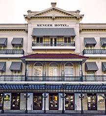
 Menger Hotel. Established in 1859, this is one of the better lobbies of any hotel. Full of history presented in glass cases around the lobby and stores, there is lots to see. The highlight is the 3-story rotunda, the original part of the hotel with its stained glass ceiling. The Menger Bar is an exact replica of the bar in the House of Lords, was where Teddy Roosevelt organized the “Rough Riders” in 1898, saw more cattle deals than anywhere else and is the oldest still operating saloon in San Antonio
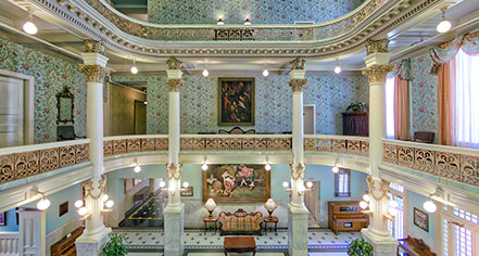
The Emily Morgan Hotel. Built in 1924, it was a Medical Arts Building from 1924 to 1976, then converted into modern office space and transformed into a hotel in 1984. The thirteen-story tower is Gothic revival and features pieces of cast iron, unique ornamentation, and a copper roof with wood ribs. The most interesting architectural feature of the building is the array of gargoyles that line the building, each portraying a medical ailment. It is now in the DoubleTree by Hilton family. It is famous for the Oro Restaurant and Bar.

River Walk (Paseo del Rio), San Antonio. This world-renowned 15-mile urban waterway is a San Antonio treasure and the largest urban ecosystem in the nation. Tucked quietly below street level and only steps from the Alamo, it provides a serene and pleasant way to navigate the city. Explore by foot along the river’s walking path or jump aboard a river barge for a ride and guided tour. In the heart of downtown, explore nearby attractions like the Alamo, the King William Historic District and more. Or, shop local favorites, dine and drink.
Rosita’s Bridge. Mexican-American singer and actress, Rosita Fernandez made a name for herself in the 1940s, 50s, and 60s by singing traditional songs from Mexico, helping to develop, transform, and popularize Tejano or “Tex-Mex” music. Singing primarily ballads and love songs called corridos, Fernandez rose to fame in a time when Tejano music was a male-dominated genre.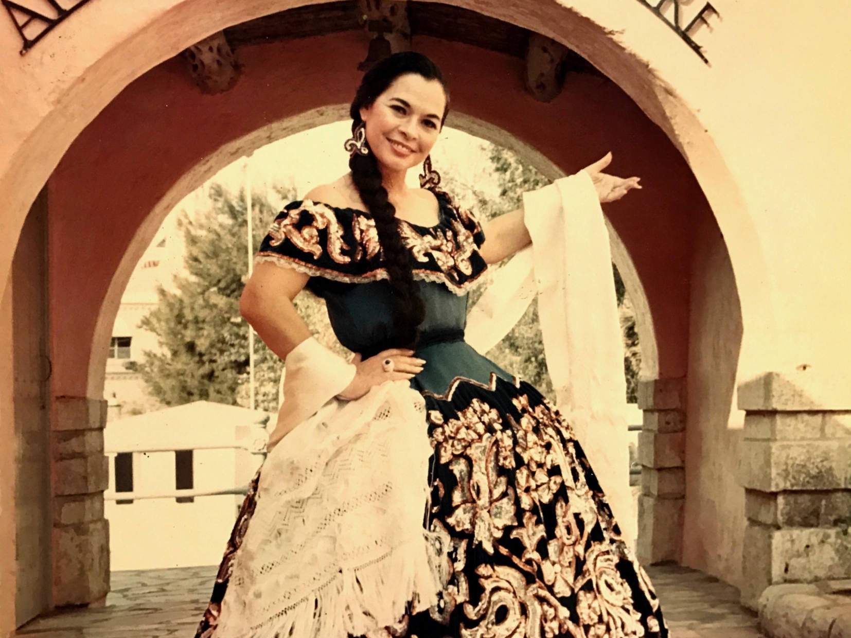
 Fernandez was born in Mexico and grew up and began her music career in San Antonio, where a lovely arched footbridge is named after the influential singer. Dedicated to Fernandez in 1982, “Rosita’s Bridge” extends over the San Antonio River near the Arnison River Theater stage where the singer performed on many occasions. Ivy grows along the sides of this stone structure as passenger barges and kayaks pass under.
Spanish Governor’s Palace is a historic adobe from the Spanish Texas period located in Downtown San Antonio. It is the last visible trace of the 18th-century colonial Presidio San Antonio de Béxar complex, and the only remaining example in Texas of an aristocratic 18th-century Spanish Colonial in−town residence. The National Geographic Society has named the landmark “the most beautiful building in San Antonio.”
 The building was constructed in the early 18th century, planned as early as 1722 and completed in 1749. The keystone above the front entrance is marked with the coat-of-arms of Spanish King Ferdinand VI and the date 1749. The building was the residence and working offices of the local presidio captain at first. Later, it became the home of the Spanish governors who lived in San Antonio. The building later became the capitol building of the Texas region of Spanish Texas in 1772. The Spanish built the Presidio San Antonio de Béxar to protect the area’s missions, including the San Antonio de Valero Mission (The Alamo) and the missions in the present day San Antonio Missions National Historical Park, as well as the growing Spanish colony.
The one-story masonry and stucco structure features ten rooms, a grand courtyard and a fountain, and is alleged to be haunted.
Market Square. This historic market is a favorite of locals and tourists with over 100 locally owned businesses that provide a unique market place experience showcasing the sights and flavors of old Mexico.

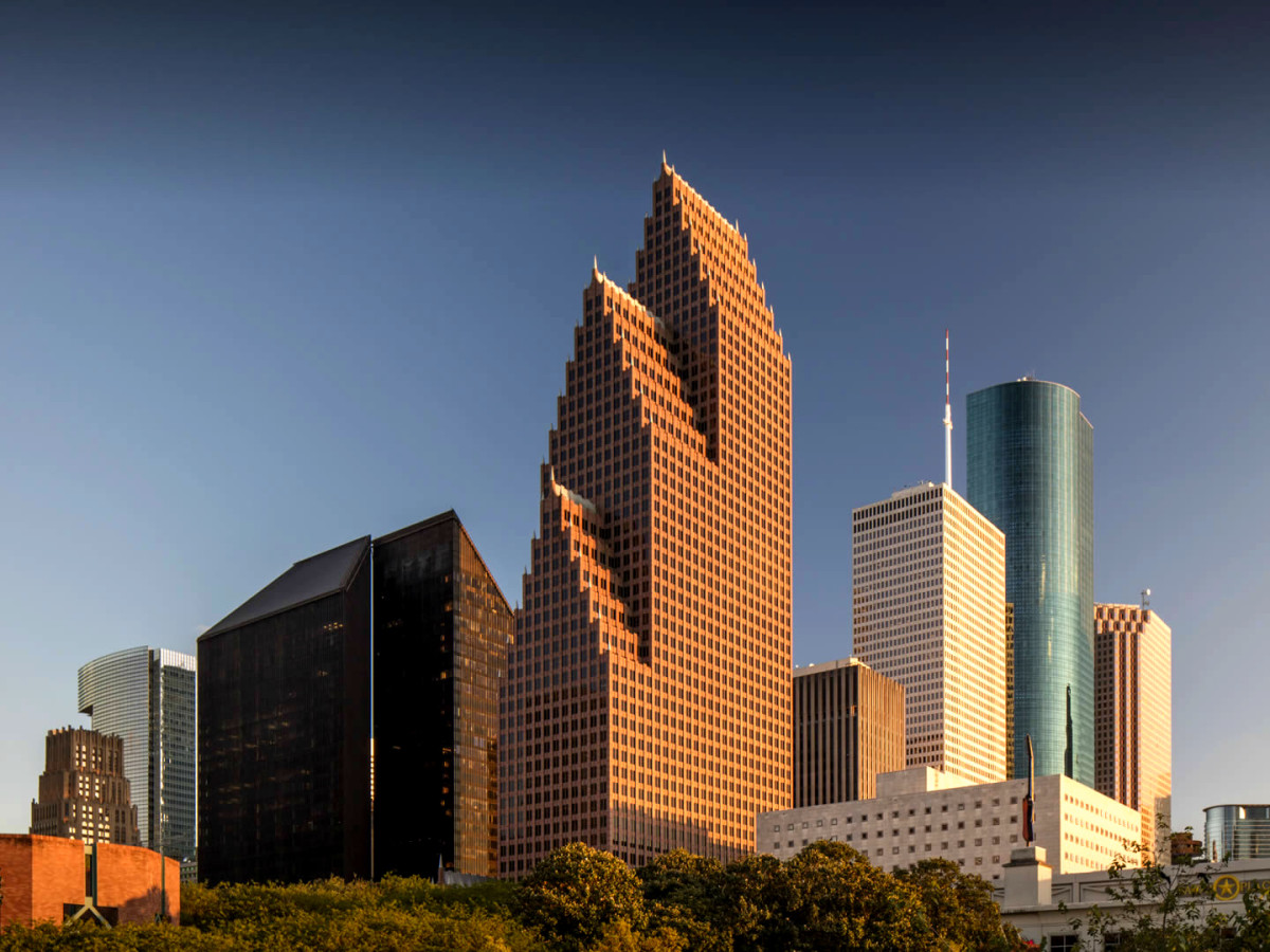
HOUSTON (pop 2,325,502)
Houston is the most populous city in Texas, fourth most populous city in the United States, most populous city in the Southern United States, as well as the sixth most populous in North America. Located in Southeast Texas near Galveston Bay and the Gulf of Mexico. The Greater Houston metropolitan area has a population of 6,997,384 in 2018.
The city of Houston was founded by land investors on August 30, 1836, at the confluence of Buffalo Bayou and White Oak Bayou. The city is named after former General Sam Houston, who was president of the Republic of Texas and had won Texas’ independence from Mexico at the Battle of San Jacinto 25 miles east
The arrival of the 20th century saw a convergence of economic factors which fueled rapid growth in Houston, including a burgeoning port and railroad industry, the decline of Galveston as Texas’ primary port following a devastating 1900 hurricane, the subsequent construction of the Houston Ship Channel, and the Texas oil boom. In the mid-20th century, Houston’s economy diversified as it became home to the Texas Medical Center—the world’s largest concentration of healthcare and research institutions—and NASA’s Johnson Space Center, where the Mission Control Center is located.
Houston’s economy since the late 19th century has a broad industrial base in energy, manufacturing, aeronautics, and transportation. Leading in healthcare sectors and building oilfield equipment, Houston has the second most Fortune 500 headquarters of any U.S. municipality within its city limits (after New York City). The Port of Houston ranks first in the United States in international waterborne tonnage handled and second in total cargo tonnage handled.
Nicknamed the “Bayou City” “Space City”, “H-Town”, and “the 713”, Houston has become a global city, with strengths in culture, medicine, and research. The city has a population from various ethnic and religious backgrounds and a large and growing international community. Houston is the most diverse metropolitan area in Texas and has been described as the most racially and ethnically diverse major metropolis in the U.S. It is home to many cultural institutions and exhibits, which attract more than 7 million visitors a year to the Museum District. Houston has an active visual and performing arts scene in the Theater District and offers year-round resident companies in all major performing arts.
Spring Skatepark. North Houston Skate Park is the largest skate park in North America. It has an incredible variety of objects. Free
Bank of America Center. In the NM “Modern Architecture Buildings” series, it was built in 1983 and is known as TC Energy Center since 2019 and serves as the company’s US headquarters. At 56 stories the TC Energy Center is the 55th tallest building in the United States and is the seventh tallest building in Texas. It is one of the first significant examples of postmodern architecture construction in downtown Houston, Texas. It has three segmented tower setbacks, each with “a steeply pitched gabled roofline that is topped off with spires. The banking center is housed in a separate building, due to construction problems, and has a three-story lobby. There are 32 passenger elevators each finished with wood panels. The building contains an art gallery in the lobby and plans to host curated exhibitions.
Houston Galleria. This upscale shopping mall in the Uptown District consists of a retail complex, as well as the Galleria Office Towers complex, two Westin hotels, and a private health club.
With 3 million square feet and 339 stores, the Galleria is the largest mall in Texas and seventh-largest in the United States.It is currently anchored by Neiman Marcus, Nordstrom, Saks Fifth Avenue, and Macy’s.
Williams Tower. In the NM “Modern Architecture Buildings” series, Williams Tower is a 64-story (909 feet, 277 m), 1.4 million square feet office tower in the Uptown District. Completed in 1982. it is among Houston’s most visible buildings as the 4th-tallest in Texas, and the 44th-tallest in the United States
In December 2002, Ryan John Hartley climbed the tower and jumped from about halfway up, resulting in his death, which was ruled a suicide.
On the morning of September 13, 2008, during Hurricane Ike, the top of the tower was damaged near the rotating beacon, many windows were blown out and suffered over $3.5 million in wind damages. Twelve of the 49 elevators were damaged, most by water damage due to roof failures and others due to extreme building sway. Major tenants: Williams Corporation, Quanta Services, Valaris plc, Cadence Bank, the Consulate General of Denmark and the headquarters for the Hines companies.
The building was built to function as two separate towers stacked directly on top of one another, one comprising the first forty floors and the other the forty-first to sixty-fourth. The building has separate banks of elevators and lobbies for each of the two building sections. There is no public observation deck. The tower was “designed to be energy efficient”.
The building became an “instant classic” when it opened. During the night-time hours, the building is defined by a 7,000 watt beacon that sweeps across the sky and can be seen up to 40 miles (65 km) away on a clear night, a Houston landmark that identifies the Uptown Houston district.
The building is connected to a 10 level, 3,208 car parking garage by a sky bridge. The bridge also connects the building to retail outlets, like The Galleria, and two Federal Aviation Administration-licensed helipads.
Sagemont Church Cross. The Sagemont Church built a 170-foot (52 m) Christian cross at Beltway 8 at Interstate 45, the largest roadside cross in Houston. It was first established in 1966 as a mission of the Pasadena church First Baptist Church. Its current church building, 118,000 square feet (11,000 m2) large, opened in 2012. This building includes a 2,496-seat sanctuary, a wing for elderly people, a wing for young people, a café, a television studio, and a bookstore. The campus altogether is 55 acres (22 ha) large. In 2012 it had 17,700 members.
GALVESTON (pop 48,000)
Galveston is a coastal resort city and port off the southeast coast on Galveston Island and Pelican Island.
Galveston, or Galvez’ town, was named after the Spanish military and political leader in the 18th century: Bernardo de Gálvez y Madrid, Count of Gálvez (1746–1786). Galveston’s first European settlements on the Galveston Island were built around 1816 by French pirate Louis-Michel Aury to help the fledgling Republic of Mexico fight for independence from Spain, along with other colonies in the Western Hemisphere of the Americas in Central and South America in the 1810s and 1820s. The Port of Galveston was established in 1825 by the Congress of Mexico following its independence from Spain. The city was the main port for the fledgling Texas Navy during the Texas Revolution of 1836, and later served temporarily as the new national capital of the Republic of Texas.
During the 19th century, Galveston became a major U.S. commercial center and one of the largest ports in the United States. It was for a time, Texas’ largest city, known as the “Queen City of the Gulf”. It was devastated by the unexpected Galveston Hurricane of 1900, whose effects included massive flooding and a storm surge which nearly wiped out the town. The natural disaster on the exposed barrier island is still ranked today as the deadliest in United States history, with an estimated death toll of 6,000 to 12,000 people. The city subsequently reemerged during the Prohibition era of 1919–1933 as a leading tourist hub and a center of illegal gambling, nicknamed the Free State of Galveston until this era ended in the 1950s with subsequent other economic and social development.
Much of Galveston’s economy is centered in the tourism, health care, shipping, and financial industries. The 84-acre (34 ha) University of Texas Medical Branch campus with an enrollment of more than 2,500 students is a major economic force of the city. Galveston is home to six historic districts containing one of the largest and historically significant collections of 19th-century buildings in the U.S., with over 60 structures listed on the National Register of Historic Places, maintained by the National Park Service in the United States Department of the Interior.
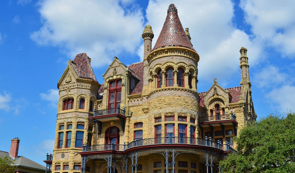
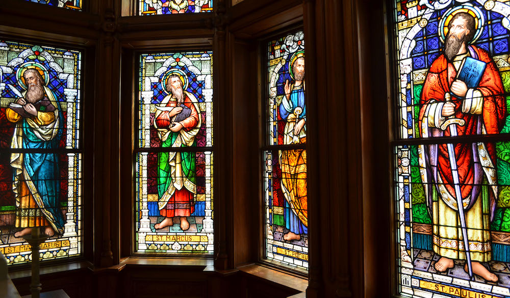
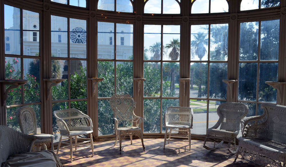
Bishop’s Palace (Gresham Castle) is an ornate 19,082 square feet (1,772.8 m2) Victorian-style house, in the East End Historic District of Galvaston. The mansion was made all of stone, and was sturdy enough to withstand the great hurricane of 1900. The Greshams welcomed hundreds of survivors of the hurricane into their home.
The house was built between 1887 and 1893 for lawyer and politician Walter Gresham, his wife Josephine, and their nine children. In 1923 the Roman Catholic Diocese of Galveston purchased the house, and, situated across the street from the Sacred Heart Church, it served as the residence for Bishop Christopher E. Byrne. After the diocesan offices were moved to Houston, the diocese opened the mansion to the public in 1963, with proceeds from tours being used to help fund the Newman Center, operating in the basement, serving Catholic students at the nearby University of Texas Medical Branch.
The home is estimated to have cost $250,000 at the time; today its value is estimated at over $5.5 million.
The house is owned by the Galveston Historical Foundation and self-guided tours are available daily. It has four floors with the raised basement followed by three formal floors. This grand stone mansion has a dramatic skyline with several towers and spires.
NOMAD MANIA Texas Southeast (Houston, San Antonio, Corpus Christi)
World Heritage Sites: San Antonio Missions
Borders
Mexico-United States
United States of America 48 states (sea border/port)
Airports: Harlingen/Valley (HRL)
Museums: Bandera: Frontier Times Museum
House Museums/Plantations: Orange: W H Stark House
Religious Temples: High Hill: St Mary’s Catholic Church
Festivals
Sandfest, Port Aransas
San Antonio: Texas Folklife Festival
Botanical Gardens: Orange: Shangri La Botanical Gardens and Nature Center
Theme Parks
Katy: Forbidden Gardens
Kemah: Kemah Boardwalk
New Braunfels: Schlitterbahn Waterpark
Lighthouses: Port Isabel: Port Isabel Lighthouse
Windmills: Victoria: Victoria Mill
Caves
Bracken Cave Preserve
Natural Bridge Caverns
Ship Museums: Rockport: Texas Maritime Museum
Railway Museums: Rosenberg: Rosenberg Railroad Museum
The Dark Side: Huntsville: Texas Prison Museum
Islands
PADRE
GALVESTON
Castles, Palaces, Forts: Galveston: Bishop’s Palace (Gresham Castle)
Maritime/Ship Museums: Galveston: Texas Seaport Museum
Cities of the Americas
COLLEGE STATION/ BRYAN
McALLEN
Airports: McAllen (MFE)
LAREDO
Museums: Border Heritage Museum
BEAUMONT
House Museums/Plantations
Chambers House Museum
The McFaddin-Ward House Historic Museum
BROWNSVILLE
Museums: Historic Brownsville Museum
House Museums/Plantations: Stillman House Museum
CORPUS CHRISTI
Airports: Corpus Cristi (CRP)
Museums:
Art Museum of South Texas
Texas Surf Museum
House Museums/Plantations: Selena Museum
Botanical Gardens: South Texas Botanical Gardens
Aquariums: Texas State Aquarium
Maritime/Ship Museums: USS Lexington
HOUSTON World Cities and Popular Towns
Airports:
Houston – George Bush (IAH)
Houston – Hobby (HOU)
Railway, Metro, Funiculars, Cable Cars: Houston METRO Rail
Museums:
Buffalo Soldier Museum
Children’s Museum
Contemporary Art Museum of Houston
Menil Collection
Museum of Fine Arts
Museum of Natural Science
Space Center Houston
Modern Architecture Buildings
Bank of America Center
Williams Tower
Zoos: Houston Zoo
Aviation Museums: 1940 Air Terminal Museum
Malls/Department Stores: Houston Galleria
Religious Monuments: Sagemont Church Cros
Maritime/Ship Museums: Houston Maritime Museum
The Dark Side: Holocaust Museum Houston
SAN ANTONIO World Cities and Popular Towns
World Heritage Sites: San Antonio Missions
Sights: River Walk, San Antonio
Airports: San Antonio (SAT)
Museums:
Briscoe Western Art Museum
McNay Art Museum
San Antonio Museum of Art
Witte Museum
Castles, Palaces, Forts: Spanish Governor’s Palace
Modern Architecture Buildings: San Antonio Public Library
Entertainment/Things to do: Six Flags Fiesta Texas, San Antonio
Zoos: San Antonio Zoo
Theme Parks: Six Flags Fiesta
Hospitality Legends
Menger Hotel
The Emily Morgan Hotel
Markets: Market Square
Monuments: Alamo Cenotaph Monument
Pedestrian Bridges: Rosita’s Bridge
Bizzarium: Barney Smith’s Toilet Seat Art Museum
+++++++++++++++++++++++++++++++++++++++++++++++++++++++++++++
TEXAS WEST (El Paso, Lubbock, Amarillo)
NOMAD MANIA Texas West (El Paso, Lubbock, Amarillo)
Tentative WHS: Big Bend National Park
Museums: Alpine: Museum of the Big Bend
World of Nature: Big Bend
Borders
Mexico-United States
United States of America 48 states (sea border/port)
Railway, Metro, Funiculars, Cable Cars: Wyler Aerial Tramway
Modern Architecture Buildings: Ransom Canyon: Robert Bruno Steel House
Caves: Caverns of Sonora
Religious Monuments: Groom: Cross of Our Lord Jesus Christ
Bizzarium
Odesa: Stonehenge Replica
Valentine: Prada in the Desert
Cities of the Americas
SAN ANGELO
AMARILLO
Airports: Amarillo (AMA)
Museums: Amarillo Museum of Art
Aviation Museums: Air and Space Museum
EL PASO
Airports: El Paso (ELP)
Railway, Metro, Funiculars, Cable Cars: El Paso Streetcar (Heritage)
Museums:
Museum of Art
Museum of History
National Border Patrol Museum
LUBBOCK
Airports: Lubbock (LBB)
Aviation Museums: Silent Wings Museum
MIDLAND/ODESSA
Airports: Midland/Odessa (MAF)
Villages and Small Towns
MARFA
Museums: Chinati Foundation