
Ege (Izmir, Aydin, Muğla, Afyonkarahisar, Denizli) April 23-26, December 22-24, 2019
I drove through here three times, my last time on my way back to Europe over Christmas. The order of the posts is a little confusing but I have tried to put them in a large loop seeing the interior and then going back north along the coast from Xanthos.
When I constructed my Nomad Mania lists over a month ago, I forgot about this province, then had a total absence of thought and drove through on April 23 seeing little but the first two places.
The road mainly went through wide flat valleys between moderate-sized mountains. Grapes and olives are the main crops.
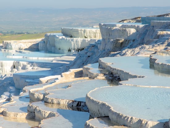
HIERAPOLIS – PAMUKKALE
Hierapolis was an ancient city located on hot springs in classical Phrygia in southwestern Anatolia. Its ruins are adjacent to modern Pamukkale and near Denizli. The hot springs have been used as a spa since the 2nd century BC, with many patrons retiring or dying there. The large necropolis is filled with sarcophagi.
History. Hierapolis was founded as a thermal spa early in the 2nd century BC within the Seleucid Empire. Antiochus the Great sent 2,000 Jewish families to Lydia and Phrygia from Babylon and Mesopotamia, later joined by more from Judea. The Jewish congregation grew in Hierapolis and has been estimated as high as 50,000 in 62 BC.
In 190 BC, Antiochus the Great was defeated by the Roman ally Eumenes II. Hierapolis became a healing centre where doctors used the thermal springs as a treatment for their patients.
Roman Hierapolis. In 133 BC, when Attalus III died, he bequeathed his kingdom to Rome. In AD 17, during the rule of the emperor Tiberius, a major earthquake destroyed the city.
Through the influence of the Christian apostle Paul, a church was founded here while he was at Ephesus. The Christian apostle Philip spent the last years of his life here. The town’s Martyrium was alleged to have been built upon the spot where Philip was crucified in AD 80.
In the year 60, during the rule of Nero, an even more severe earthquake left the city completely in ruins. Afterwards, the city was rebuilt in the Roman style with imperial financial support. It was during this period that the city attained its present form. The theatre was built in 129 for a visit by the emperor Hadrian and renovated in 193. When Caracalla visited the town in 215, he bestowed the much-coveted title of neocoros upon it, according to the city certain privileges and the right of sanctuary. This was the golden age of Hierapolis. Thousands of people came to benefit from the medicinal properties of the hot springs. New building projects were started: two Roman baths, a gymnasium, several temples, a main street with a colonnade, and a fountain at the hot spring. Hierapolis became one of the most prominent cities in the Roman Empire in the fields of the arts, philosophy, and trade. The town grew to 100,000 inhabitants and became wealthy.
During the 4th century, Christianity had become the dominant religion and begun displacing other faiths in the area and Justinian raised the bishop of Hierapolis to the rank of metropolitan in 531. The Roman baths were transformed to a Christian basilica. During the Byzantine period, the city continued to flourish and also remained an important centre for Christianity.
Medieval Hierapolis. In the early 7th century, the town was devastated first by Persian armies and then by another destructive earthquake, from which it took a long time to recover. In the 12th century, the area came under the control of the Seljuk sultanate of Konya before falling to Crusaders under Frederick Barbarossa and their Byzantine allies in 1190. About thirty years later, the town was abandoned before the Seljuks built a castle in the 13th century. The new settlement was abandoned in the late 14th century. In 1354, the great Thracian earthquake toppled the remains of the ancient city. The ruins were slowly covered with a thick layer of limestone.
Today. The Hellenistic city was built on a grid with the main street about 1,500 metres long and 13.5 metres wide bordered on both sides by an arcade. At both ends of the main street, there was a monumental gate. The Frontinus gate is well preserved carefully squared travertine blocks, with elegant arches.
Theatre. Constructed by Hadrian after the earthquake of 60 AD, the facade is 300 feet (91 m) long, the full extent of which remains standing. There are 50 rows of seats and a scaenae frons organized on three storeys and flanked by two imposing side entry buildings.
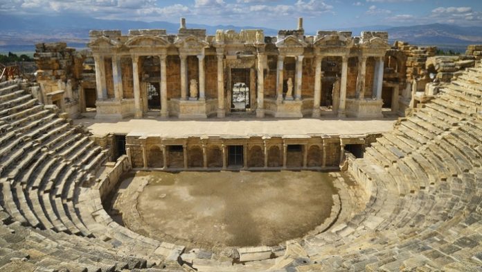
The auditorium was rebuilt as well, consisting of stacked seating with a capacity of 15,000. The lower part originally had twenty rows and the upper part twenty-five, but only thirty rows altogether have survived and was extensively restored between 2004 and 2014.
Temple of Apollo, the town’s principal god during the late Hellenistic period, now only the foundations of the Hellenistic temple remain. It was deliberately built over an active fault called the Plutonion.
Ploutonion, a shrine to the Greek god Pluto, is a cave with stairs and carbon dioxide gas.
During the early years of the town, castrated priests of Cybele descended into the plutonion, crawling over the floor to pockets of oxygen or holding their breath. Carbon dioxide is heavier than air and so tends to settle in hollows. The priests would then come up to show that they were miraculously immune to the gas and infused with divine protection. An enclosed area of 2,000 square metres stood in front of the entrance. It was covered by a thick layer of suffocating gas, killing anyone who dared to enter it. The priests sold birds and other animals to the visitors so that they could try out how deadly this enclosed area was. Visitors could (for a fee) ask questions of Pluto’s oracle. This provided a considerable source of income for the temple. The entrance to the plutonion was walled off during the Christian times and has just been recently unearthed.
Necropolis. Beyond the city walls and following the main colonnaded road, an extensive necropolis extends for over 2 kilometres. The road leads to Phrygian Tripolis and Sardis. This necropolis is one of the best preserved in Turkey with most of the 1,200 tombs made of limestone dating from the late Hellenic period
Sawmill. A raised relief on the Sarcophagus of a certain Marcus Aurelius Ammianos, a local miller, depicts the earliest known machine to incorporate a crank and connecting rod. On the pediment, a waterwheel fed by a mill race is shown powering via a gear train two frame saws cutting rectangular blocks by the way of connecting rods and, through mechanical necessity, cranks.
Antique Pool. Especially in the Roman Empire, Hierapolis was a health center with thousands of people coming to the more than 15 baths. Cleopatra’s Pool had water with values of 36–57 °C, pH value is 5.8 and radon value is 1480 pCi/l. 35 TL
Pamukkale
LAODIKELA
This was a Hellenistic city from 261-47 BC when it became Roman. Hadrian bestowed the name Neokros on it and it was the home of Anitchus, Theodorus and a well-known medical school. Two earthquakes razed it to the ground in 60 AD and 494 AC. Another in 602 caused it to be abandoned. In its heyday, it had the biggest stadium in Anatolia, 2 theatres, 4 baths, 5 agoras, 5 fountains and several temples. Syria Street is colonnaded. House A had 47 rooms. Temple Apollo has had 19 columns reerected. The highlight is the Christian basilica which has been extensively restored with glass walkways. An early Christian Council was held here between 341 and 381 (the first was at Nicea in 325). The list of 60 rules is very interesting (it was not good to be a heretic). Terracotta sewer pipes are exposed and most of the marble and mosaic floors are exposed. The baptistery has a pool 1.45m in diameter and 1m deep. 15 TL.
The ruins of the church are now covered by a large roof and restored
Denizli is an industrial city in the southwestern part of Turkey and the eastern end of the alluvial valley formed by the river Büyük Menderes at an elevation of about 350m.
The city has a population of about 577,000 (2013 census). This is a jump from 389,000 in 2007, due to the merger of 13 municipalities and 10 villages when the area under Denizli Municipality jurisdiction increased almost fivefold and the population around 50 percent.
Denizli has seen economic development in the last few decades, mostly due to textile production and exports.
Denizli also attracts visitors to the nearby mineral-coated hillside hot spring of Pamukkale and with red colour thermal water spa hotels Karahayıt, just 5 kilometres (3 miles) north of Pamukkale.
The ancient ruined city of Hierapolis, as well as ruins of the city of Laodicea on the Lycus, the ancient metropolis of Phrygia. Also about 16 km west of Denizli is, what was, in the 1st century AD, the city of Colossae.
The weather is hot in Denizli in the summers, whereas in winter, it may occasionally be very cold with snow on the mountains that surround the city. Some years, snow can be observed in the urban areas. Springs and autumns are rainy, mild climate, and warm.
APHRODISIAS
This was a small ancient Greek Hellenistic city in the historic Caria cultural region of western Anatolia, Turkey. It is located near the modern village of Geyre, about 100 km (62 mi) east/inland from the coast of the Aegean Sea, and 230 km (140 mi) southeast of İzmir.
Aphrodisias was named after Aphrodite, the Greek goddess of love, who had here her unique cult image, the Aphrodite of Aphrodisias that is particular to Aphrodisias – she was a distinctive local goddess who became identified with the Greek Aphrodite and doubtless was once housed in the Temple of Aphrodite.
In the surviving images, she wears a thick, form-disguising tunic, her feet are of necessity close together, her forearms stretched forward, to receive and to give. She is adorned with necklaces and wears a mural crown together with a diadem and a wreath of myrtle, draped with a long veil that frames her face and extends to the ground. The bands of decoration on the tunic, rendered in bas-relief, evoke the Goddess’s cosmic powers
In 2017 it was inscribed on the UNESCO World Heritage Site list.
Aphrodisias was the metropolis (provincial capital) of the region and Roman province of Caria.
History. White and blue-grey Carian marble was extensively quarried from adjacent slopes in the Hellenistic and Roman periods, for building facades and sculptures. Sculptors from Aphrodisias became famous in the Roman world. Many examples of statuary have been unearthed in Aphrodisias, and some representations of the Aphrodite of Aphrodisias also survive from other parts of the Roman world, as far afield as Pax Julia in Lusitania.
The city had notable schools for sculpture, as well as philosophy, remaining a centre of paganism until the end of the 5th century. The city was destroyed by an earthquake in the early 7th century, and never recovered its former prosperity, being reduced to a small fortified settlement on the site of the ancient theatre.
Sometime before 640, in the Late Antiquity period when it was within the Byzantine Empire, the city was renamed Stauroúpolis (“City of the Cross”). to remove pagan connotations, but already by the 8th century it was known as Caria after the region, which later gave rise to its modern Turkish name, Geyre. In Byzantine times, the city was the seat of a fiscal administrative unit (dioikesis).
The city was sacked again by the rebel Theodore Mankaphas in 1188, and then by the Seljuk Turks in 1197. It finally fell under Turkish control towards the end of the 13th century.
Geologic History. The site is in an earthquake zone with a great deal of damage especially in the 4th and 7th centuries. One of the 4th-century earthquakes altered the water table, making parts of the town prone to flooding. Evidence can be seen of emergency plumbing installed to combat this problem.
Aphrodisias never fully recovered from the 7th century earthquake, and fell into disrepair. Part of the town was covered by the modern village of Geyre; some of the cottages were removed in the 20th century to reveal the older city. A new Geyre has been built a short distance away.
Ecclesiastical History. In the 7th century, Stauropolis had twenty-eight suffragan bishops and twenty-six at the beginning of the 10th century.
Stauropolis is also a Roman Catholic titular metropolitan see, under the name Stauropoli.
Buildings.
Temple of Aphrodite. This was a focal point of the town. The Aphrodisian sculptors became renowned and benefited from a plentiful supply of marble close at hand. The school of sculpture was very productive – many full-length statues, sarcophagi decorated garlands and columns and pilasters described as “peopled scrolls” with figures of people, birds and animals entwined in acanthus leaves.
The temple was altered when it became a Christian basilica and dismantled in c. 481-484 by order of Emperor Zeno. The temple was the focus of Pagan Hellenic opposition against Zeno, in support of Illus, who had promised to restore Hellenic rites suppressed during the Persecution of pagans in the late Roman Empire.
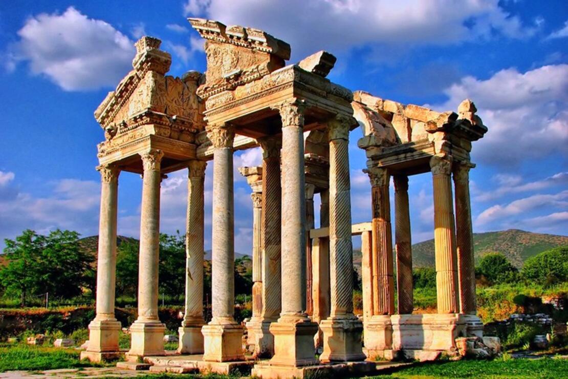
Monumental Gateway. Built in 200 AD, it leads to the forecourt in front of the Temple.
Bouleuterion. The council house or odeon, today is a semicircular auditorium fronted by a shallow stage structure about 46 m wide. The lower part of the auditorium survives intact, with nine rows of marble seats. The upper twelve rows have collapsed together with its supporting vaults. The seating capacity is estimated at 1,750.
Stadium. Measuring 270 m by 60 m with 30 rows of seats on each side, and around each end, it would have had a maximum capacity for around 30,000 spectators. The track measures approximately 225m by 30m. As the stadium is considerably larger and structurally more extensive than even the stadium at the Sanctuary of Apollo at Delphi, it is probably one of the best-preserved structures of its kind in the Mediterranean
Inscriptions. The quality of the marble in Aphrodisias has resulted in an unusually large number (about 2000) of inscribed items surviving in the city. Funerary and honorary texts are well represented with texts from all periods from the Hellenistic to Byzantine.

Excavations in Aphrodisias have also uncovered an important Jewish inscription whose context is unclear. The inscription, in Greek, lists donations made by numerous individuals, of whom several are classed as ‘theosebeis’, or Godfearers. It seems clear through comparative evidence from the inscriptions in the Sardis synagogue and from the New Testament that such Godfearers were probably interested gentiles who attached themselves to the Jewish community, supporting and perhaps frequenting the synagogue. The geographical spread of the evidence suggests this was a widespread phenomenon in Asia Minor during the Roman period.
Frieze. A frieze discovered in 1980 showing a bare-breasted and helmeted female warrior labelled BRITANNIA writhing in agony under the knee of a Roman soldier with to the left and below the inscription TIBERIUS CLAUDIUS CAESAR is assumed to depict Britain subjugated by Rome.
Ancient city of Kibyra Tentative WHS (13/04/2016). Near the modern town of Golhsar, this Roman town sits high above the town. As you climb the hill, pass a great mausoleum and necropolis to reach the magnificent stadium, the best in Anatolia. Dating from the 2nd century AD, it has 10,000 seats and a 200m oval runway. There are 21 rows of seats on the west slope and 8 on the east, the latter built on a rubble wall. It was possible to see the plains and lake in the distance over the Lower East Side. Races, gladiator and gladiator/animal fights were held. Free as many renovations was happening in the visitor center.
The seats were mostly intact but all the columns and arches at the top were gone but one.
The Ancient City of Sardis and the Lydian Tumuli of Bin Tepe. This is a tentative WHS (15/04/2013), but I think should be upgraded. It has one of the most intact buildings in the Roman world. The entire back, sidewalls and interior are completely intact. Two stories high, there are 2 levels of 5X8 columns. Most of the columns and capitals in the front are also still standing. The rest of the ruins have two temples with many columns. A 4th-7th century Roman house is across the road. Painted marble and columns are still visible in the apse and one sidewall. Below are excavations of a Lydian house destroyed by Cyrus the Great of Persia in 543 BC.
Google Maps was a real screw-up in this area. First, it took us 12 km to a sheep pasture, supposedly where the Lydian tumuli of Bin Tepe were. Sardis was a garage on the side of the highway. We eventually followed signs in the nearby town to the ruins. There are ruined walls dotting the countryside attesting to the size and importance of Sardis.
Mountainous Phrygia (13/04/2015). Phrygia was the name of an ancient Anatolian kingdom (12th-7th century BCE) and, following its demise, the term was then applied to the general geographical area it once covered in the western plateau of Asia Minor. With its capital at Gordium and a culture which curiously mixed Anatolian, Greek, and Near Eastern elements, one of the kingdom’s most famous figures is the legendary King Midas, who acquired the ability to turn all that he touched to gold, even his food. Following the collapse of the kingdom after attacks by the Cimmerians in the 7th century BCE, the region came under Lydian, Persian, Seleucid, and then Roman control.
History. The fertile plain of the western side of Anatolia attracted settlers from an early period, at least the early Bronze Age, and then saw the formation of the Hittite state (1700-1200 BCE). The first Greek reference to Phyrgia appears in the 5th-century BCE Histories of Herodotus (7.73). The Greeks applied the name to the Balkan immigrants who, sometime after the 12th century BCE, relocated to western Anatolia following the fall of the Hittite Empire in that region. The kingdom’s traditional founder and first king were Gordios, a legendary figure, most famous today as the creator of the ‘Gordian Knot’, a fiendishly difficult piece of rope work the king had used to tether his cart. The story goes that an oracle had foretold that the person who knew how to untie the knot would rule over all of Asia, even the whole world. The cart and the knot were, incredibly, still there at Gordium when Alexander the Great (356-323 BCE) arrived a good few centuries later. Alexander was said to have heard the story and, rather unsportingly, sliced the knot open with a single blow of his sword. In other accounts, the young general slipped the pin out of the cart’s yoke pole and slid the knot off that way.
The neighbouring states of Phrygia, which similarly formed out of the remnants of the Hittite Empire, were Caria (south), Lydia (west), and Mysia (north). Phrygia’s territory expanded to reach Daskyleon in the north and the western edge of Cappadocia. Phrygia prospered thanks to the fertile land, its location between the Persian and Greek worlds, and the skills of the state’s metalworkers and potters. Chamber tombs, especially at the capital Gordium, have distinctive doorways and their excavated contents have revealed both the use of the language of Indo-European Phrygian (from the 8th century BCE) and the wealth which gave rise to the legend of the fabulously rich King Midas (see below).
Phrygia was conquered by the Cimmerians in the 7th century BCE but the period of domination by Lydia and Persia has left an impoverished archaeological record. Phrygia continued to be used as a label of convenience for the general and ill-defined geographical area which had once been ruled by the now-defunct kingdom of that name.
After the campaigns of Alexander the Great, the region of Phrygia/Lydia came under the control of one of Alexander’s successors, Antigonus I (382-301 BCE). Shortly after, Anatolia became a part of the Seleucid Empire c. 280 BCE. As a consequence of this takeover, many settlers came from ancient Macedon and their Hellenistic culture with them. Notable Phrygian towns in this period besides Gordium included Hierapolis, Laodikeia by the Lykos (aka Laodicea), Aizanoi, Apamea, and Synnada, although most of the region’s population lived in small, agriculturally-based villages.
Phrygia became a part of the Roman province of Asia (with a part in Galatia, too) in 116 BCE.
Phrygia then became embroiled in the Mithridatic Wars of the 1st century BCE between Rome and the kings of Pontus. With the reign of Augustus (27 BCE – 14 CE), there followed a period of peace and stability in the region. Prosperity was ensured by the continued fertility of the land and the important marble quarries near Dokimeion – stone from there would be used in such buildings as Trajan’s Forum in Rome and the Library of Celsus at Ephesus. Into the 3rd century CE, the culture of the region had become a mix of indigenous Anatolian, Greek, Roman, Jewish, and Christian practices and customs.
King Midas. Perhaps the most famous figure from Phrygia’s long history is Midas(r. 738 BCE – c. 696 BCE), the king who reputedly could turn anything he wished into gold. According to the legend, Midas had helped the satyr Silenus recover from the morning-after effects of a night of overdrinking and restored him to his master, the god of wine Dionysos. In gratitude, the god granted Midas a single wish and so the king gained his ability to turn anything he touched into gold. Rather too good to be true, this skill proved a bit of a problem when Midas wanted to eat or drink as even these things changed into the precious metal. Asking Dionysos to withdraw his wish, Midas was told he could lose the bothersome ability if he washed in the river Pactolus in Lydia (a river, not coincidentally, famous for its gold dust deposits). Midas might have been a wealthy mortal but he seems to have been unlucky with the gods twice. In another unfortunate encounter, this time with Apollo, the king offended the deity when he was asked to judge who was the better musician, Pan or Apollo. Midas unwisely chose Pan, and a displeased Apollo turned the king’s obviously tone-deaf ears to those of a donkey. The king was obliged to wear a turban for the rest of his days.
Gordium. The capital of the kingdom Gordium, the city was strategically located at the point where the main land route to the east coast – often called the Persian ‘Royal Road’ – crossed the ancient Sangarios River (modern name Sakarya River and about 100 km or 62 miles west of Ankara). The settlement likely became the most important one in the Phrygian kingdom from the 10th century BCE. Gordium was sacked by the Cimmerians during their invasion of the region but did recover, albeit never really regaining anything like its former glory. The Romans destroyed the town during their campaign against the Galatians in 189 BCE, and by the 1st century CE, it was nothing more than a village.
Impressive remains which can be visited today include the well-preserved Temple of Zeus at Aizinoi (92 CE), the Roman theatre at Hierapolis (2nd century CE), and the Temple A at Laodicea (2nd century CE).
Lübbey. In the NM “small towns” series, this was a slow drive 28 km south of Sardis. The road went over the top of a mountain with the middle 4 km on a dirt logging road. The main economy is, besides logging, growing ornamental shrubs – every house has fields of black plastic pots filled with shrubs (cedars, evergreens and plants). We passed through a town at the bottom of the logging road that probably had never seen a Western tourist before.
The road turned to dirt again past a big mine and then descended into Lubby. The west side of the village was a ghost town of stone houses, almost all with caved-in roofs. The other side of the gulch had some occupied brick homes. A fountain beside the road gushed water.
Continuing along, we ran literally into a dam, drove along the east side, got stopped and went along the west side, crossed over the crown of the dam and descended into the town of Ödemiş. It appeared the dam would flood the entire valley that Lübbey is in, even though there is not much of a river. We stopped at a small roadside eatery and had a massive very thin tortilla stuffed with cheese for lunch. The woman spoke a lot of Turkish to us.
Historic Town of Birgi. A tentative WHS (13/04/2012), dates back to 3000 BC with Phrygian, Lydia, Persian and Byzantine rule. In the 11th century, the Seljuks took control. In 1307, Aydinofu Mehmet Bey declared the town his capital.
In 1315, he built the Aydinoglu Mehmet Bey Mosque which is still in use today. In a square shape with 16 columns inside, it has a wooden ceiling and a turquoise tile mihrab. The highlight is the mimbar (pulpit) made by M. Usta, a master of wood carving without a single nail or glue. The Iman, in very broken English, gave me a tour explaining the infinite number of octagons and squares in the intricately carved pulpit. The carved door to the mimbar had been stolen by the British but was returned in 1996. The original minaret was in the right front corner and was replaced by a magnificent turquoise and brick minaret.
Next to the mosque is the tomb of Aydinoguilari Turbesi with 4 graves. And in the square next to the mosque is the tomb of Sultan Sah Turbesi from 1310.
Also in the town was a university, baths, mansion and library.
It was almost 3 hours to drive to Aizanol. First, we crossed a high mountain pass.
AIZANOI ANTIQUE CITY. This is a tentative WHS (13/04/2012). When you first arrive, many old houses are falling apart with their roofs caved in. An ancient bridge made of marble that is not usable has deep wheel ruts. The entire 5 spans are supported by a wood framework.
Temple of Zeus. Construction started in 92 AD in the period of Roman emperor Domitianus (81-96 AD) and continued in the period of Hadrian (117-138 AD). It is a rare example of a mostly intact temple. Of the original 8 X 15 columns, 15 columns are still standing. The north and west walls of the temple are intact. Stairways lead down to a large barrel-vaulted room under the temple.
There are a huge number of grave stelae displayed on one side with good descriptions. Many have wonderful carvings. A large stone carving of ? Medusa is beside the temple. 6 TL
The drive to Xanthos and the coast was through some great snow-covered mountains (over three passes – 1370, 1595 and 1390m), supposedly one of the top ten drives in the world.
XANTHOS – LETOON. These two ancient sites combine to make one World Heritage Site. About 7kms apart, the main ruins at both are primarily Roman.
The towns are about 90% greenhouses with small bits of normal housing/businesses and streets. Tomatoes appear to be the only crop.
Letoon. Letoon was a sanctuary of Leto near the ancient city of Xanthos in Lycia. It was one of the most important religious centres in the region. The site is located south of the village Kumluova and approximately 4 km south of Xanthos along the Xanthos River.
History. It was never a fully occupied settlement, but remained essentially a religious centre, dating back to the late sixth century BCE.
The foundations of the Hellenistic temple dedicated to Leto, and her children, Artemis and Apollo bear inscriptions in Greek, Lycian and Aramaic, which has provided crucial keys in the deciphering of the Lycian language. The site was Christianised by the construction of an early church, which reused cut stone from the sanctuary, but was abandoned from the seventh century CE.
There is a well-preserved theatre, a lot of ruined walls, columns and pediments and then on a platform on the west side a temple with 3 columns. 35 TL
Xanthos. This was Lycia’s religious and administrative centre. The citizens put up a heroic resistance to Persian armies in 545 BC, but were overwhelmed – the women and children were killed, the town burnt and all the men committed suicide with only a few families surviving. It was again burned to the ground in the years 475-450 BC. In 40 BC, Brutus occupied the city and the citizens fought to the death. Under the Romans, especially in the 2nd century AD, Xanthos regained its former influences thanks to wealthy Lycians. It was the seat of the bishopric during the Byzantine era.
There is an inscribed Obelisk (ca. 400 BC, a funerary pillar for a sarcophagus that probably belonged to Kheriga, a small theatre, the “Harpy Tomb” of Kybernis, a solid sandstone pillar with the sarcophagus of Kybernis on top (c.480 BC). 15 TL
Ancient Cities of Lycian Civilization Tentative WHS (06/02/2009). Lycia was a geopolitical region in Anatolia in what is now Antalya and Mugla on the southern coast of Turkey. Lycia voluntarily incorporated into the Achaemenid empire in the Iron Age (546 BC), their language disappeared and the area had an influx of Persian speakers.
Lycia fought for the Persians in the Persian Wars, was defeated by the Greeks (part of the Athenian Empire), came under the Persians, revolted, returned to the Persians and finally became Macedonian under Alexander the Great when it became thoroughly Hellenized. On defeating Antiochus III in 188 BC the Romans gave Lycia to Rhodes for 20 years, taking it back in 168 BC. In these latter stages of the Roman Republic Lycia came to enjoy freedom as a Roman protectorate. The Romans validated home rule officially under the Lycian League in 168 BC. This native government was an early federation with republican principles. Despite home rule, Lycia was not a sovereign state and had not been since its defeat by the Carians. In 43 AD the Roman emperor Claudius dissolved the league, and Lycia was incorporated into the Roman Empire with provincial status. It became an eparchy of the Eastern, or Byzantine Empire, continuing to speak Greek even after being joined by communities of Turkish language speakers in the early 2nd millennium. After the fall of the Byzantine Empire in the 15th century, Lycia was under the Ottoman Empire and was inherited by the Turkish Republic on the fall of that empire. The Greek and Turkish population was exchanged when the border between Greece and Turkey was negotiated in 1923.
The principal cities of ancient Lycia were Xanthos, Patara, Myra, Pinara, Tlos and Olympos (each entitled to three votes in the Lycian League).
After seeing Xanthos, the plan was to head east to see the rest of the western Mediterranean part of Turkey and we drove about 50 km along the gorgeous coast passing Kas in a lovely setting of islands and bays. The road ran along the cliffs.
When I constructed my Nomad Mania lists over a month ago, I had omitted Ege province, then had a total absence of thought and basically drove through on April 23 seeing little but the first two places. We decided to return to Izmir but this time drive the coast.
In Kas, we used the wonderful showers at the Kas Yacht Club/Marina (on the far west end of town). On my way back through Turkey on December 22, I returned to this marina and had another great shower. At the security just say you are “going shopping” or “eating at a restaurant” as there are shopping and two restaurants here. The bathrooms are carded but there are showers outside or go in the morning when they clean the bathrooms and leave the door open for the deluxe shower inside.
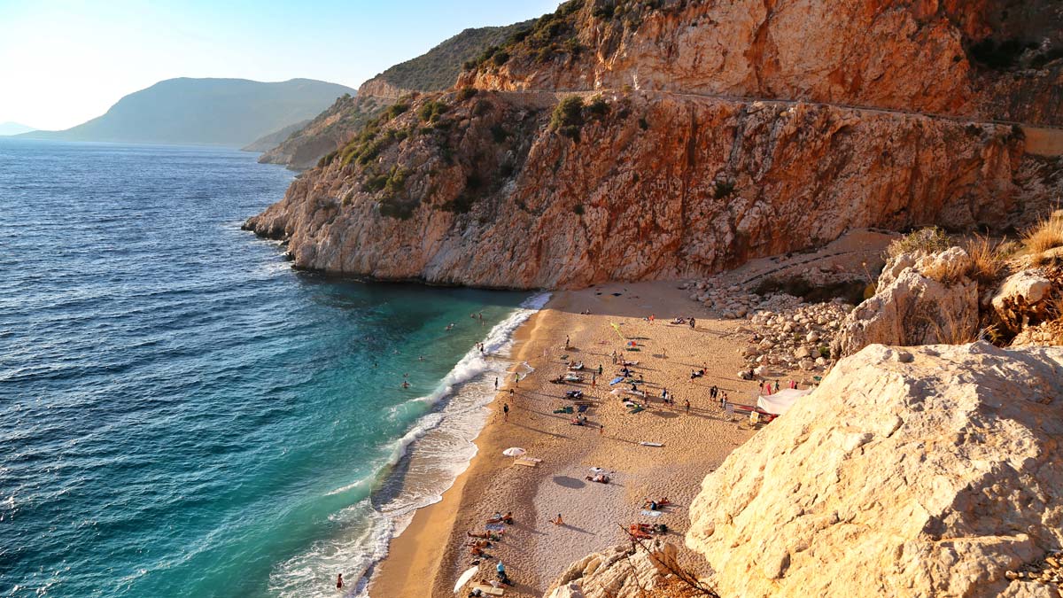
Kaputas Beach. Backed by a deep slot canyon this is a wonderful small spot of sand between cliffs. A very popular tourist spot, there were at least 6 tents on the beach and several swimming.
Mugla Museum, Mugla. Bones, some interesting gladiator gravestones, pots and a small ethnography exhibit. Not of much interest. Zero English. Free
Patara Beach, Gelemis. This 2km long stretch of coarse sand beach is near the archaeological site of Patara, just north of Letoon. It is necessary to pay to pay the 15TL entrance fee to the site to access the beach.
Kabak Beach. This was a 42km drive very much out of the way – and then the same drive to continue travelling north as the road did not continue. Needless to say, we did not go here. The NM listing gives its location as Fethiye but it is quite farther south and not accessible from the city of Fethiye.
Blue Lagoon, Ölüdeniz. 12 km south of Fethiye, this is a small beach. There are many blue lagoons in the world (Belize, Malta). Near here is the Ghost Town, a village abandoned by Greeks and now a popular tourist destination.
Fethiye Beaches. The city beaches are on the north side of the city. They are pebble/coarse sand. The area is the highly touristed part of the city.
Ancient City of Stratonikeia. A tentative WHS (13/04/2015), this is unique in having some elements of the several controlling empires: Hittites, Ptolemies, Macedonians, Rhodes, Romans (continuous building program especially in the 2nd century, Byzantine, Ottoman and Turkish Republic periods. Five families still live in the ancient city and there has been little excavation. It appears that attempts are being made to renovate it for tourism purposes. The theatre is in bad repair, fountain, colonnaded street, many low walls, and city council buildings are all discernible but would take a lot of work to make sense of the massive site. Free
Medieval City of Beçin. A tentative WHS (13/04/2012), this fortified city sits on top of a volcanic cone above the city of Milas. Its heyday was in the 1200 – 1406 when it had a population of 7-800 and was taken over by the Ottomans, after which it declined. The last inhabitants left in the 1950s. Little is left but crumbling walls and a partially intact hamam. The only reason to come is for the great views down to Milas and the plains around. Free

BODRUM. In the NM “Popular Town” and “Site” series, Bodrum is one of those very popular seaside resort towns that draw a horde of tourists. The white houses cascade down the hillsides to the harbour full of big boats, both motored and sailed, that offer trips to the Greek islands, primarily Kos but also Leros, Rhodes, Symi, Patmos, Samos and Datca.
Bodrum Castle. A tentative WHS (13/04/2016), this imposing grey stone castle sits at the tip of the peninsula in downtown Bodrum. You can walk the ramparts and visit a lovely mosque. 20 TL
The Bodrum Museum of Underwater Archaeology is permanently closed.
Mausoleum and Sacred area of Hecatomnus (13/04/2012). Halicarnassus (modern Bodrum, Turkey) was an ancient Ionian Greek city of Caria, located on the Gulf of Cerameicus in Anatolia. According to tradition, it was founded by Dorian Greeks of the Peloponnese. The most famous of her sons, the historian Herodotus, wrote that in early times the city participated in the Dorian festival of Apollo at Triopion, but the city’s literature and culture appear completely Ionic and Herodotus’ Histories were written in Ionic Greek. Halicarnassus has become linked with the birth of written history as it was the native city of Herodotus, `The Father of History’ but, in its time, it was better known as one of the great urban trade centers of Asia Minor.
The city, with its large sheltered harbour and key position on the sea routes, became the capital of the small kingdom, the most famous ruler of which was King Mausolus. His wife Artemisia built the great Tomb of Mausolus after his death, the so-called Mausoleum of Halicarnassus, one of the Seven Wonders of the Ancient World. Will Durant writes:
The sculptural masterpiece of the period [4th century BCE] was the great mausoleum dedicated to King Mausolus of Halicarnassus. Nominally a satrap of Persia, Mausolus had extended his sway over Caria and parts of Ionia and Lycia and had used his rich revenues to build a fleet and beautify his capital.
Under the rule of Artemisia and Mausolus, the city underwent a great renewal in architecture and infrastructure as the monarchs wished their city to be the jewel of Anatolia. A great wall circuit, public buildings, and a secret dockyard and canal were built as well as many well-ordered roads and temples to the gods.
The city was besieged by Alexander the Great in 334 BCE (the famous Siege of Halicarnassus) where he almost suffered defeat (it would have been his only one) but, at the last minute, his infantry broke the walls and burned the Persian ships. The Persian commander, Memnon of Rhodes, realizing the city was lost, set fire to it and fled. The fire consumed most of the city. Alexander set his ally, Ada of Caria, to rule Halcarnassus and she, in turn, formally adopted him as her son so that his bloodline would always reign in the city he had taken from the Persians.
After Alexander’s death, however, rule of the city passed to Antigonus I (311 BCE), Lysimachus (after 301 BCE) and the Ptolemies (281–197 BCE) and was briefly an independent kingdom until 129 BCE when it came under Roman rule. A series of earthquakes destroyed much of the city as well as the great Mausoleum while repeated pirate attacks from the Mediterranean wreaked further havoc on the area.
By the time of the early Christian era, when Halicarnassus was an important Bishopric, there was little left of the shining city of Mausollos. In 1404 CE the Christian Knights of St. John used the ruins of the Mausoleum to build their castle in Bodrum (which still exists today and where one may still see the stones which once were part of a Wonder of the ancient world). The ruins of the city were extensively excavated in 1856–57 CE and again in 1865 CE and much of its great wall, the gymnasium, a late colonnade, a temple platform, rock-cut tombs and the site of the Mausoleum (littered with those stones not used by the knights) may still be seen today.
Archaeological Site of Priene. In the 4th century BC, the city was surrounded by 2.5 km of walls (6m high, 2m wide) that extended to the base of the cliff above. Remnants are all over but best represented at the East Gate on exiting the site. Destroyed by an earthquake in the second half of the 2nd century BC, it was rebuilt by the Romans who arrived in 129 BC. In the 1st to the 4th century, the harbour silted up and it declined. There was a reinvigoration in the early Christian/Byzantine times with the building of a church.
Climb up the great stairs beside a rock wall and turn right to go to the theatre (6500 seats and an intact stage) and then the highlight, the Sanctuary of Athena from the 4th century BC with 6 by 11 columns.
We visited early in the morning before the ticket office was open and had this great site to ourselves.
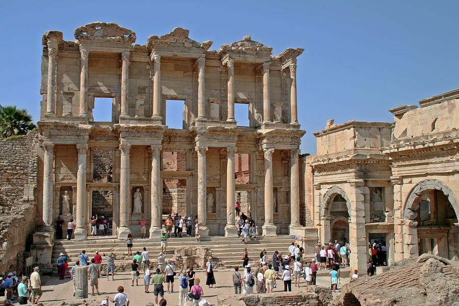
EPHESUS
This WHS is a big tourist draw in western Anatolia.
History. First settled in 6500 BC, subsequent rulers were the Lydians in 560, Persians in 546, Alexander the Great in 343, and the Greeks who built a 9km wall, theatre and stadium starting in 294 BC. In 133 BC, the Romans made it tax-exempt. In 88 BC, 80,000 were murdered putting down a revolt. In 30 BC, Marc Antony and Cleopatra spent the winter here but were defeated by Octavius at the battle of Actium. He made Ephesus the capital city of Roman Asia. In 52 the Apostle Paul visited. The 2nd century AD saw its zenith with monument building. After an earthquake in 230, it declined, hastened by Gothic raids in 250. The 5th -14th century saw a Byzantine revival and then a decline under the Ottomans.
The highlights buildings are:
Theatre dates from 3rd to the 1st century and was renovated by the Romans twice.
Celsus Library was built in 100-110 AD by Gaius Aquila over his father’s burial chamber. It was destroyed in the earthquake of 270 and re-erected in 1970-78. The great façade has 2 stories with 8 columns each and columnar carving on the face. Statues are in the niches. The huge agora is 154m by 112m. A colonnaded street was closed.
Sirince. In the NM “small town series”, this village is a major tourist spot. Located 7.5 km up a switchbacking road above the city of Siljuk. Its name means “cute” in Turkish, and used to be called “Çirkince,” meaning “ugly.” This was an ironic take on the beauty of the village and also used to ward off others. As people wised up to how spectacular the village’s location and architecture were, they changed the name to Şirince in 1926.
The two-storey architecture is special and any new building is required to align with the aesthetic of the village, which is under preservation. The homes are connected through windy, cobbled, narrow streets. Its location on a hill and its fertile fields have made it a haven for vineyards, olive orchards (with great local olive oil), peaches, figs, apples, walnuts and more. It is well-known for fresh produce, and a special Turkish breakfast with an array of cheeses, olives, tomatoes, cucumbers and jams. Local herbs are used in many of the more substantial meals, picked from the hills and often cooked using local olive oil.
 The Şirince bazaar is one of the better markets on the Aegean coast with foodstuffs, the freshest produce, trinkets, souvenirs, jewelry, soaps, dried fruit, and handmade clothing. Turkish coffee is brewed using a pan filled with hot sand that makes the coffee taste strong and thick.
Doganbey. Many travellers certainly know the abandoned Greek village Kayaköy near Fethiye on the Lycian coast. Its ruined houses evoke the memories of ancient Greek inhabitants of Turkey. However, few people know that a very similar place exists on the Aegean coast, close to the renowned holiday resort of Kuşadası.
Originally called Domatia, after 1924, Doğanbey was settled by the Turks, but in the 80s of the 20th century, they left the village in search of more modern conditions of life. Since then the village has remained uninhabited. As a result, it managed to retain its original character and old buildings in the state from almost a hundred years ago. Some of the buildings have been restored and sold as holiday homes, but many old houses are still falling into disrepair.
Currently, Doğanbey is a village museum, where you can admire the beautiful examples of traditional architecture of the 19th and early 20th centuries. Among the old houses, there is also a historic church and a chapel. The village is divided by a deep ravine where the stream flows. There is an Information Centre
In the NM “small town series”, the road from Sirince to here was twisty following the coast, then turned into a 6-lane divided to Cesme.
ÇESME and Karaburun Peninsula. Extending west from Izmir, this seaside town has ferries to Chios, the main island in the Greek northern Aegean Islands. I booked a ferry to Chios for December 22 with plans to eat Greek food for 3 days over Christmas. But the ferry was cancelled because of high winds. That ferry line had no sailings until 18:30 on Dec 26 so I would have returned to Turkey on the 28th and had a very rushed drive to get the ferry from Greece to Venice on Dec 31. But I was able to get a passenger-only ferry on the 23rd so went to Chios for the day and gave me almost 4 more days to get to the other side of Greece.
Çeşme Castle. This impressive large castle on the waterfront of Cesme has a large square keep, mosque and museum. TL14
Altinkum beach, Didum. This is a lovely, white, fine sand beach but with very junky surroundings – garbage and run d0wn businesses.
Alaçatı Windmills Park.
IZMIR
Ataturk Mask. This huge head of Ataturk is carved into a large rock next to a busy road.
Izmir Art and Sculpture Museum (Ege University Ataturk Culture Museum). The first floor had an exhibit of photography that was very mediocre – basically snapshots of uninteresting scenes and no artistic use of light. The second floor was an exhibit of paintings of a local artist – and oddly she was present. Some were interesting landscapes. The third floor has a permanent exhibit of paintings from about 1900 to the 1990s, all local artists, surrounding some sculptures in the centre of the floor. Free
Izmir Ethnography Museum. Next door to the Archaeology Museum, there was a carpet loom, several 19th-century carpets and the usual collection of traditional dress, some furnished rooms and local collections. Free
Izmir Archaeological Museum. Again the usual from Stone Age to Byzantine exhibits with the majority Roman. 12 TL
Izmir Toy Museum (Umran Baradem Toy Musuem). This small museum high above the previous museums had a wide variety of toys, art, dolls, mechanized toys, playhouses and rooms. Free
Kemeralti Bazaar. This huge downtown market occupies several blocks with a maze of lanes. Buy most anything. I bought some sunglasses (25 TL ~€4) and we had an unusual pizza “Turkish style” made by a group of old men running the business.
Izmir Ataturk Museum. Across from the waterfront north of the Bazaar, this is the definitive Ataturk museum about his entire life (I visited one in Northern Macedonia where he went to high school and one in Istanbul where he lived in 1919). This man is much loved by the Turkish people and is a true national hero.
Hilton Izmir. This 35-floor skyscraper (142m or 466 feet) hotel near the old town has a panoramic restaurant on the top floor. Upon its completion in 1991, Hilton Izmir became the tallest building in the city, and the third tallest building in Turkey after the 52-floor (176.8 metres (580 ft)) Mertim Tower (1987) in Mersin, and the 29-floor (143 metres (469 ft), including the spire) Sheraton Ankara (1991) in Ankara. Hilton Izmir remained the tallest building in Izmir and the Aegean Sea until 2014 when the 47-floor (200 m (656 ft)) Folkart Twin Towers were completed. The exterior is white marble and has interesting “wavy” windows.
Folkart Towers. Built in 2014, this 47-floor (200 m (656 ft)) twin tower complex has 210 apartments and 213 offices. They were the tallest buildings in İzmir between 2014 and 2017, until the completion of the 48-floor (216 m (709 ft)) Mistral Office Tower. Upon their completion in 2014, the Folkart Towers were the 5th tallest twin towers in Europe. They have a large art gallery and cinema complex.
World Peace Monument. On a hill in north Izmir, this monument consists of a steel-framed globe with a walkway on the equator. Views are 360°.
Latif Hanim Mansion and Memorial House. Latif Hanim (1900-) was from a wealthy family and educated abroad, could speak English, French, Persian, Arabic, and German. Ataturk’s (Mustafa Kemal) mother was ill and moved in with the Hanim family in Izmir. She was cared for by Latif but died in 1923.
Ataturk and Latif married in 1923, but only for a short time and she moved to Istanbul.
The 2-story house was decrepit and had a total major restoration beginning in 2007. It is now furnished in period pieces with wax figures of Ataturk, his mother and Latif. Free
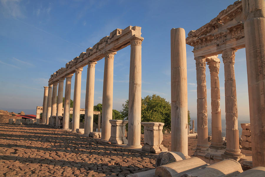
PERGAMON and its MULTI-LAYERED CULTURAL LANDSCAPE World Heritage Sites (2014)
History. Pergamon is one of the rare settlements that has survived several invasions and devastations over the ages but is reoccupied again on the merits of its strategic location. Its prehistory dates to the second millennia BC. The city survived Persian domination and the conquest of Alexander the Great.
Pergamon was an important kingdom during the second century BC, having grown from a city-state captured by Alexander the Great. Upon Alexander’s death in 323 BC, his generals fought for control of the parts of his empire. Lysimachus took command of the Aegean coast but was killed in 281 BC, leaving Pergamum in control of Philetarus the Eunuch (283-263 BC), who used Lysimachus’s treasure to increase his power.
The most brilliant phase of its history lasted almost one hundred and fifty years when it was the capital of the Kingdom of Pergamon during the 3rd and 2nd centuries BC. Philetarus’s nephew and heirs built on their inheritance, and Eumenes II (197-159 BC), King of Pergamon, became the most powerful ruler in Anatolia. At this time, one of the largest libraries of the world was built here and the city became a healing centre. The arts also flourished, and the city particularly became renowned for magnificent sculptures. He beautified his capital city by building the Altar of Zeus, by constructing numerous buildings in the “middle city” on the slope of the Acropolis, and by expanding and beautifying the Asclepion Medical Center. At the Sanctuary of Asclepius, one of the principal healing centres of antiquity, the patients were treated with the sound of water, mud baths and waters of a healing spring. Pergamon was also the home of physician Galen, the father of pharmacology, making the city stand out in the history of medicine and pharmacology.
Eumenes II’s son Attalus III (159-129 BC) was not his father’s equal. Pergamum’s power declined, and on Attalus’s death, the Kingdom of Pergamum was willed to Rome and became its Province of Asia (Minor).
During the Roman period, Pergamon maintained its significance and developed further becoming “the most famous and magnificent city of the Asia Minor”, as described by the 1st century AD philosopher and author Pliny the Elder. Roman Pergamum was still a rich, important city. Some of its most important monuments, such as the Temple of Trajan, date from Roman times. The Serapis Temple dedicated to Egyptian gods was one of the principal structures of the Roman era and it was renowned as the Red Basilica due to the colour of the bricks used.
During the Byzantine era, this noticeably huge structure was converted to a church, which is one of the first Seven Churches cited in the Bible.
Firsts. Pergamon had many firsts in its history. One of the most significant of these was the first-ever use of parchment. The invention of the script has been a breakthrough in the history of humanity, and the innovation of parchment was quite important as it created a medium, enabling quick and stable recording of scripts. The development of parchment allowed Pergamon to create a library of 200,000 manuscripts that rivalled the world-renowned library of Alexandria and paved the way to develop the city as an important centre of arts and science in the 2nd century BC. The Pergamon Gymnasium was one the most important learning institutions of the Hellenistic Era.
Pergamon had one of the first Seven Churches of early Christianity, the first theatre with a wooden stage; the first trade union; the first market law; the first public building regulation; and the first strike and collective agreement amongst other firsts.
Open Air Museum. Pergamon sits on top of the mountain or the Acropolis. The principal ruins of the ancient Pergamon, comprising all the religious, social and commercial structures, are in the acropolis – the ten thousand-seat theatre where the audience enjoyed the magnificent vista of Pergamon Valley; the Sanctuary of Athena and the Temple of Dionysus; the Sanctuary of Trajan, the Royal Palaces of Pergamon, the Base of Great Altar of Pergamon, or the Zeus Altar (the superstructure of the Altar was dismantled and transported to Germany in the late Ottoman Era and it is now on display in Berlin – the Altar and its friezes show the best examples of the art and architecture of Pergamon in the Hellenistic Era).
You can take either the cable car (TL35) or drive up. The parking area at the top is small and normally also has a high fee, but was not collected in December.
Walk up into the ruins and turn right to see the remnant walls of the Royal Palaces. Continue along the edge of the ridge for wonderful views down to a reservoir to the north. At the 5m wide well, start on the boardwalk that continues on the ridge, past the arsenal and aqueduct, cross back through the walls and reach the Sanctuary of Trajan, the only real thing of much interest to see. Surrounded by fluted marble columns (only some connected by a capital) and a plaza, the temple is an elevated platform in the center. 6 columns, part of a capital and the gable end are reconstructed on the platform.
The storyboards here are the worst I have ever seen giving a lot of boring information about the reconstruction and little about what is here. Besides the sanctuary of Trajan, the best reason to come is the magnificent 360° views. TL42
Bergama. Following the Roman and Byzantine eras, Pergamon came under Turkish domination. Today’s Bergama contains examples of the Seljuk and Ottoman architecture, such as mosques, bathhouses and bridges. Most prominent of these include the Ulu Cami (the Grand Mosque), Selçuklu Minaresi (the Seljuk Minaret), Şadırvan Cami (the Ablution Fountain Mosque), Çukur Han (the Sunk Caravanserai), and Taş Han (the Stone Caravanserai). There are also examples of 18th and 19th century civil architecture at the Kale Mahallesi (Citadel Neighbourhood) which is situated at the lower slopes of the hill where the Pergamon city was once built.
The art of sculpture reached its peak in the 2nd century BC in Pergamon and statues created in that era are admired even today. The Pergamon style became one of the principal schools of sculpture, magnificent examples of which can be seen in the Museum of Bergama. The most striking works are the statues of gods, goddesses and emperors, which were unearthed in the excavations
The thermal springs of Pergamon made the city one of the principal centres of healing and beauty in antiquity, and many of them reached our times. One of the major thermal spas of Pergamon is within the Sanctuary of Asclepius (Güzellik Ilıcası) which is 4 km from Bergama. It is believed to have been commissioned by King Euamens of Pergamon and provided beautifying services to Cleopatra who enjoyed bathing there.
