
Rhineland-Palantine Jan 23-24, 2019
Rhineland-Palatinate is located in western Germany, covering an area of 19,846 square kilometres (7,663 sq mi) and a population of 4.05 million inhabitants, making it the seventh-most populous German state. Mainz is the state capital and largest city, while other major cities include Ludwigshafen am Rhein, Koblenz, Trier, Kaiserslautern, and Worms. The states of North Rhine-Westphalia, Saarland, Baden-Württemberg, and Hesse surround Rhineland-Palatinate. It also borders three foreign countries: France, Luxembourg and Belgium.
The state was established in 1946 after World War II from the territory of the historically separate regions of the Free State of Prussia, the People’s State of Hesse, and Bavaria, by the French military administration in Allied-occupied Germany. Rhineland-Palatinate became part of the Federal Republic of Germany in 1949, and shared the country’s only border with the Saar Protectorate until it was returned to German control in 1957. Rhineland-Palatinate has since developed its own distinct identity, built on its natural and cultural heritage, including the extensive Palatinate wine-growing region, its picturesque landscapes, and numerous castles and palaces.
The Joint German-Luxembourg Sovereign Region (Gemeinschaftliches deutsch-luxemburgisches Hoheitsgebiet) is the only unincorporated area of the state of Rhineland-Palatinate. This condominium is formed by the rivers Moselle, Sauer, and Our, where they run along the border between Luxembourg and Rhineland-Palatinate or the Saarland.
With 42% of its area covered by forests, it is the most forested state, alongside Hesse. The state’s major rivers are the Rhine, including the UNESCO World Heritage Site of the Middle Rhine, and the Moselle. There are several crater lakes of volcanic origin in the Eifel, the biggest of which is the Laacher See.
Religion. As of 2016, 41.7% of the state’s population adhered to the Roman Catholic Church, and 28.0% to the Evangelical Church in Germany. Approximately 30.3% of the population is irreligious or adheres to a religion other than the dominant one. Muslims made up 2.5% of the total.
Industry. Rhineland-Palatinate leads all German states with an export rate of approximately 50%. Essential sectors include the wine-growing industry, chemical industry, pharmaceutical industry, and auto parts industry. “Distinctive regional industries” include the gemstone, ceramic, glass, and leather industries. Small and medium enterprises are considered the “backbone” of the economy in Rhineland-Palatinate. The principal employer is the chemical and plastics processing industry.
KOBLENZ (pop 112,000) is situated on both banks of the Rhine where the Moselle joins it. Koblenz was established as a Roman military post around 8 B.C. Its name originates in the Latin (ad) cōnfluentēs, meaning “(at the) confluence” Of the two rivers. The actual confluence is today known as the “German Corner”, a symbol of German reunification that features an equestrian statue of Emperor William I. The city celebrated its 2000th anniversary in 1992. After Mainz and Ludwigshafen am Rhein, it is the third-largest city in Rhineland-Palatinate.
/KoblenzGettyImages-758685099SinaEttmer-5a665bbc88f4fb0037d9d39e.jpg)
Cable car
The DB Museum in Koblenz was opened on 21 April 2001 as the first remote site of the Nuremberg Transport Museum. It is housed in the former goods wagon repair shop built in 1905 as part of the rebuilding and expansion of Lützel goods station into the Koblenz-Lützel locomotive depot.
Various exhibits are displayed on the open part of the site. The museum’s collection of vehicles includes more than 20 locomotives and wagons. The central themes of the exhibitions are electric trains and rail travel. A model railway, built in modular (Nordmodul) fashion, recalls the atmosphere of the steam age in the post-war years. €5
Mittelrhein-Museum (Middle Rhine Museum). The Koblenz art museum is housed with Romanticum and the City Library in a fantastic new building, the Forum Confluentes cultural centre.
Today, it houses more than 2000 years of art and cultural history of the Rhineland. In total there are about 20,000 treasures and works of art from prehistoric times to the present, including more than 1,100 paintings, about 8,000 graphics and drawings and over 300 sculptures and numerous objects from the fields of arts and crafts, furniture, textiles, militaria, archaeological finds, building fragments, photographs, ceramics and coins in the museum. In the field of contemporary art, works by KO Götz and Heijo Hangen are exhibited in larger work complexes. €6
Romanticum. Discover the myths and legends of the Upper Middle Rhine Valley in an interactive experience aboard a virtual steamboat. The Romantic Period on the Rhine occurred around the mid-19th century, when steamboats began to ply the Rhine. €6
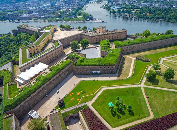
Ehrenbreitstein Fortress is a fortress on the east bank of the Rhine where it is joined by the Moselle, overlooking the town of Koblenz. Since 2002, Ehrenbreitstein has been part of the UNESCO World Heritage Site, the Upper Middle Rhine Valley.
Occupying the site of an earlier fortress destroyed by the French in 1801, it was built as the backbone of the regional fortification system, Festung Koblenz, by Prussia between 1817 and 1828. It guarded the middle Rhine region, an area that French troops had repeatedly invaded. The Prussian fortress was never attacked.
Ehrenbreitstein, the hill on which the eponymous fortress is now located, was first settled in the 4th millennium BC Fortifications were built in the 10th/9th century BC. Between the 3rd and 5th centuries AD, a Roman fortification was situated there. More settlements followed in the 8th/9th centuries under the Carolingian dynasty. In about 1000, Ehrenbert erected a castle on the hill. During the 16th century, work began to turn the castle into a fortress that could withstand the new gunpowder weapons.
Ehrenbreitstein guarded the most valuable relic of the Trier See, the Holy Tunic, from 1657 to 1794. In 1688, the fortress successfully withstood a siege by France. Around 1730, a third ring of fortifications was created.
In 1794, French revolutionary troops conquered Koblenz and besieged Ehrenbreitstein three times, but were unsuccessful. However, a one-year siege, starting in 1798, brought starvation to the defenders, who finally handed over the fortress to French troops in 1799. They were eventually forced to withdraw from the right bank of the Rhine. They blew up Ehrenbreitstein in 1801 to prevent the enemy from taking hold of a fully functional fortress just a few meters away from French territory on the left bank of the Rhine.
Today’s fortress. According to the Congress of Vienna in 1815, the Rhineland was ceded to Prussia. The fortification of the Koblenz area became a Prussian military priority because of its proximity to France and the fact that Koblenz was a bottleneck for all means of transportation (ships, railways, land transportation because of bridges). They built a system of fortification around Koblenz, of which the Festung Ehrenbreitstein was a part. Fortress Koblenz was reportedly the largest military fortress in Europe, except for Gibraltar. Ehrenbreitstein could be defended by up to 1200 soldiers.
The actual construction of the new fortress took place from 1817 to 1828, and it was ready for service by 1834. Subsequently expanded several times, by 1886, Koblenz was classified as a fortification of lesser importance. After the Koblenz fortifications west of the Rhine were dismantled between 1890 and 1903, the fortress and some lesser structures on the east bank alone covered the Rhine crossing until 1918.
During its years of active service, the fortress was never attacked. It escaped being dismantled after the end of World War I due to its perceived historical and artistic value.
After World War II, it was handed over to the State of Rhineland-Palatinate in 1947. Between 1946 and 1950, it served as a refugee camp and later as residential housing during the period of housing shortages that lasted from the early 1950s into the 1960s. In 1952, a youth hostel was established, followed by the opening of a museum in 1956. In 1972, the Ehrenmal des Deutschen Heeres (a memorial to the dead of the German army) was inaugurated.
The fortress is open to visitors. It is connected to the town of Koblenz across the Rhine by a cable car and by an inclined lift to the foot of the hill. Ehrenbreitstein houses several museums on photography, archaeology) and other subjects, as well as the Landesmuseum, gastronomic establishments, and the youth hostel with 157 beds. The fortress serves as a venue for various cultural events, including open-air concerts and plays.
Could you take the Koblenz cable car up to the fortress?
Stolzenfels Castle (Schloss Stolzenfels) is a former medieval fortress castle turned into a palace, on the left bank of the Rhine. Stolzenfels was a ruined 13th-century castle gifted to the Prussian Crown Prince, Frederick William, in 1823. He had it rebuilt as a 19th-century palace in Gothic Revival style. Today, it is part of the UNESCO World Heritage Site Upper Middle Rhine Valley. After substantial renovation work, the castle and its parks were reopened in 2011. The castle is open to the public.
I couldn’t find out how to get to it. Google Maps stopped beside the river, and there were no stairs.
Fernmeldeturm Koblenz is a freestanding telecommunications tower located on the Kühkopf mountain near Koblenz. It was built between 1972 and 1976, is 260.7 m (855.3 ft) high, and is not accessible to visitors.

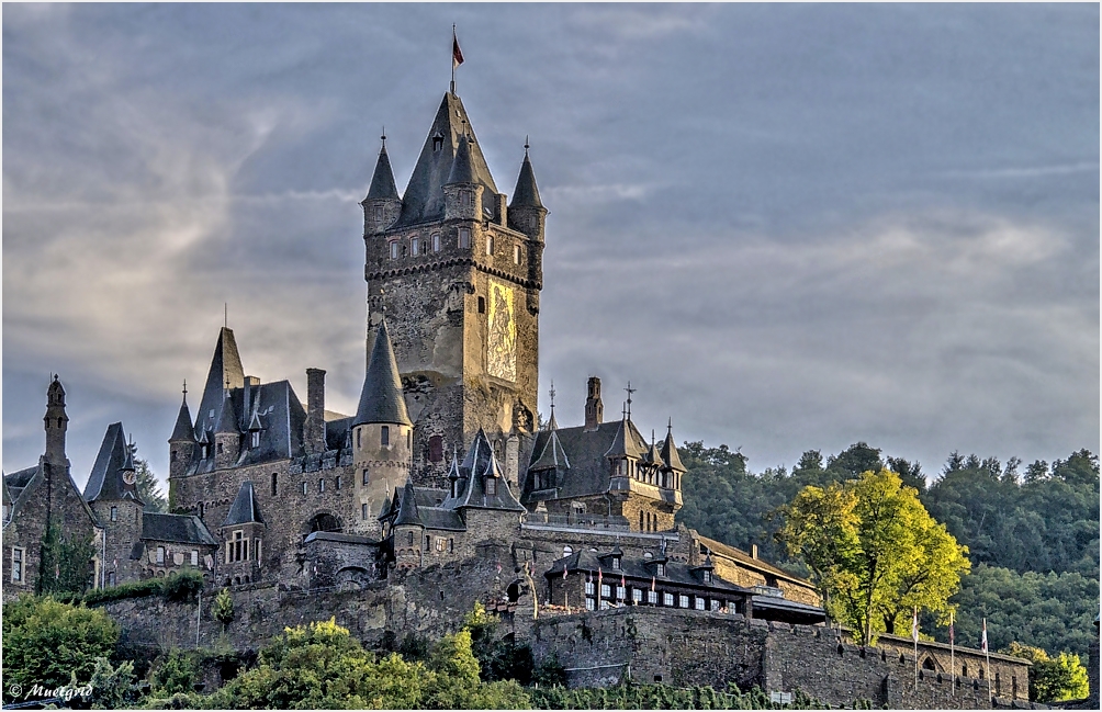
The drive to Cochem was through rolling farm land, a long winding descent through a narrow valley, and then a switchbacking narrow cobble road up to the castle.
COCHEM (pop 5,000)
On the left bank of the Moselle, it was only after a bridge was built across the river in 1927 that the two fishing villages of Cond and Sehl amalgamated.
History. As early as Celtic and Roman times, Cochem was settled. In 1332, Cochem was granted town rights, and shortly thereafter, the town fortifications, which still stand today, were built. In WWII, significant parts of Cochem’s old town were destroyed. Also, during the war, the operations staff of the underground subcamp of Zeisig of the Natzweiler concentration camp between the villages of Bruttig and Treis was located here. At its height, 13,000 people were imprisoned. They provided slave labour for Bosch, which made spark plugs, ignition systems, and glow plugs, which were essential to the German war effort, under brutal conditions.
Reichsburg Cochem. In 1151, King Konrad III declared it an Imperial castle. In 1688, the castle was overrun by the French, who destroyed it. The castle complex had long lain in ruins until 1868, when it was purchased by the Berlin businessman Louis Fréderic Jacques Ravené for 300 Goldmark and subsequently reconstructed in the Gothic Revival style. Since 1978, it has been owned by the town of Cochem.
It sits high above the town, another fairytale castle with gates, rough stone walls, and a massive square tower with a stark painting on the side. The views from the panorama, with the cannon overlooking the river and town, are fantastic. Then drive down through the narrow cobble streets of Cochem to the tiny square and the fountain.

Edelstein-Museum (Gemstone Museum and Historic Grinding Shops). Has lots of rocks and then the jewelry made from them.
Pinnerkreuz, a lookout point overlooking the town and the former Imperial castle (Reichsburg), which can be reached by chairlift. There is also a promenade along the Moselle. Further points of interest are the historic Senfmühle (“Mustard Mill”) and the water gauge house on the Moselle.
Saint Roch’s Plague Chapel
Bundesbank-Bunker Cochem. In 1962, the Deutsche Bundesbank constructed a secret bunker in Cochem-Cond, 30 meters underground, disguised as two houses within the training and recreation center of the Deutsche Bundesbank. The bunker’s vault held a reserve series of German mark banknotes totalling 15 billion marks during the Cold War, intended to enter circulation in case the Eastern Bloc would try to weaken the West German economy by massively counterfeiting the existing DM banknotes. To open the vault, bank officials from Frankfurt would have to bring over three different keys and a lock combination.
TRIER (pop 105,000)
Formerly known in English as Treves, it is on the Moselle. Trier lies in a valley between low, vine-covered hills of red sandstone in the western part of the state, near the border with Luxembourg and within the important Moselle wine region. The German philosopher and one of the founders of Marxism, Karl Marx, was born in the city of Trier in 1818.
History. Founded by the Celts in the late 4th century BC, it was later conquered by the Romans in the late 1st century BC. It was renamed Trevorum, making Trier possibly the oldest city in Germany.
The nearest major cities are Luxembourg (50 km or 31 miles to the southwest), Saarbrücken (80 km or 50 miles southeast), and Koblenz (100 km or 62 miles northeast). Trier is renowned for its well-preserved Roman and medieval architecture in the Old Town.
Antikencard. The basic card (€12) includes 2 Roman monuments and the Landesmuseum, while the premium card (€18) includes 4 Roman monuments – both are valid for a year.
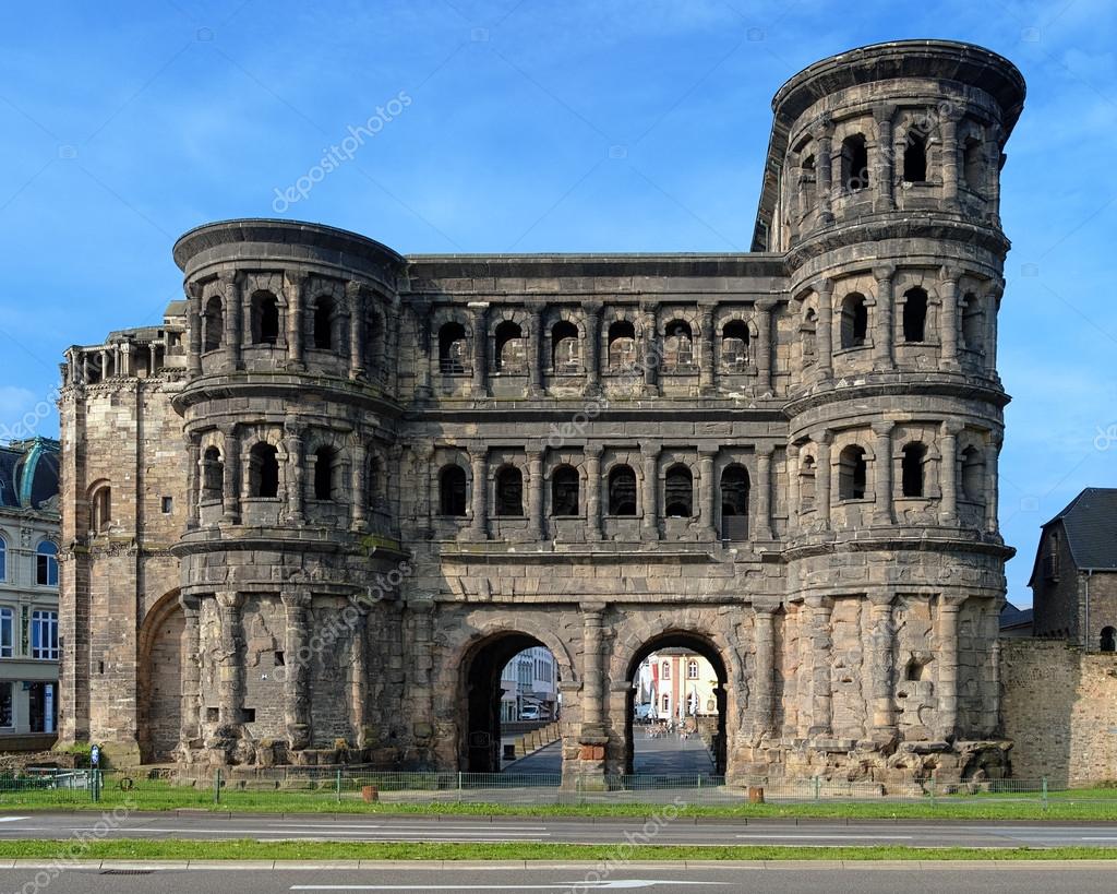
Roman Sites
Porta Nigra, the best-preserved Roman city gate north of the Alps.
Roman Trier Amphitheatre; the 2nd century AD Roman bridge (Römerbrücke) across the Moselle, the oldest bridge north of the Alps still crossed by traffic
Ruins of three Roman baths, among them the largest Roman baths north of the Alps, including the Barbara Baths and the Trier Imperial Baths.
The Constantine Basilica, a basilica in the original Roman sense, was the 67 m (219.82 ft) long throne hall of Roman Emperor Constantine; it is today used as a Protestant church. Although it is a massive brick monstrosity, it is closed except on Sundays.
Trier Cathedral (Trierer Dom or Dom St. Peter), a Catholic church that dates back to Roman times, features a Romanesque west façade with an extra apse and four towers, which is imposing and has been copied repeatedly. There are many grand altars festooned with marble statues. The great marble font could immerse an entire person. At the front is a vast black sarcophagus surrounded by beautiful inlaid wood walls. The best tomb is that of Johannes Philopus, featuring a wonderful marble skeleton. The highlight of the church is the “Seamless Robe” or Holy Tunic, said to be the robe Jesus was wearing when he died (it has been dated to the first century). It is housed in a special glass case in a dedicated chapel located behind the altar. It is brought out for viewing rarely on special pilgrimage occasions: yearly from 1510-17, every 7 years from 1524-45, then in 1585, 1655, 1810, 1844, 1891, 1933, 1959, 1996, and last in 2012. The subsequent viewing is unknown. The Cathedral is home to the Holy Tunic, a garment, as well as many other relics and reliquaries in the Cathedral Treasury. World Heritage Site.
Liebfrauenkirche (Church of Our Lady) is one of the most important early Gothic churches in Germany, in some ways comparable to the architectural tradition of the French Gothic cathedrals. World Heritage Site with the Trier Cathedral. Free
Rheinisches Landesmuseum is a crucial archaeological museum for the Roman period, featuring huge mosaics, grave monuments, and the most extensive Roman gold treasure (coins) in the world. The highlight is the stone “wine boat”. Additionally, there are some early Christian and Romanesque sculptures. €8
Karl Marx House. Karl Marx (1818-1888) was born in this house. The family moved out in 1819, and the house was renovated and expanded multiple times to produce the present gorgeous house. It was only discovered in 1907 that Marx was born in this location. Exhibits Marx’s personal history, volumes of poetry, original letters, and photographs, accompanied by personal dedications. There is also a collection of rare first editions and international editions of his works. Still, the main thrust of the museum is exhibits on the development of socialism in the 19th century and its philosophy. He first met Frederick Engels in 1844, and together they developed many of the ideas that would later become known as Marxism. €3.50 reduced
Roscheider Hof. An ethnological and open-air museum in the neighbouring town of Konz, situated right at the city limits of Trier, which showcases the history of rural culture in the northwest of Rhineland-Palatinate and in the area where Germany, Luxembourg, and Lorraine meet.
St. Matthias’ Abbey is a still-in-use monastery in which the medieval church holds the remains of the only apostle north of the Alps.
St. Gangolf’s church is the city’s ‘own’ church near the main market square (as opposed to the Cathedral, the bishop’s church), primarily Gothic.
Saint Paulinus’ Church is one of the most important Baroque churches.
Treadwheel cranes: Gothic “Old Crane” or “Trier Moselle Crane” from 1413, and the other, the 1774 Baroque crane, the “(Old) Customs Crane” or “Younger Moselle Crane”
Rhineland-Palatinate (Mainz, Koblenz, Trier)
World Heritage Sites:
Frontiers of the Roman Empire. By the early 2nd century, the Roman Empire had reached its territorial peak. Rather than constantly expanding their borders, the Romans solidified their position by fortifying their strategic locations with a series of fortifications and establishing lines of defence. The Romans had reached the natural limits that their military traditions afforded them, and beyond the borders of the early-to-mid Empire lay peoples whose military traditions made them militarily unconquerable, despite many Roman battle victories. The borders fluctuated throughout the empire’s history. They were a combination of natural frontiers (the Rhine and Danube rivers to the north and east, the Atlantic to the west, and deserts to the south) and artificial fortifications which separated the lands of the empire from the “barbarian” lands beyond.
Under Hadrian’s rule, which began in 117, the Roman frontier was systematically fortified. He spent half of his 21-year reign touring the empire and advocating for the construction of forts, towers, and walls along the empire’s edges. The coherent construction of these fortifications on a strategic scale (i.e., to protect the empire as a whole rather than fortifying individual settlements) is known as the limes and continued until around 270.
The limes consisted of fortresses for legions or vexillations as well as a system of roads for the rapid transit of troops and, in some places, extensive walls.
Perhaps the most famous example of these is Hadrian’s Wall in Great Britain, which was built across the entire width of the island to protect from attack from tribes located in modern-day Scotland. In some cases, a river, desert, or natural outcropping of rock can provide the same effect with no outlay. Also, fortifications as impressive as Hadrian’s Wall were not unbreachable: with mile castles some distance apart and patrols infrequent, small enemy forces would have been able to penetrate the defences easily for small-scale raiding. However, a raiding party would be forced to fight its way through one of the well-defended gates, abandon its loot, such as cattle, thus negating the whole purpose of the raid or be trapped against the wall by the responding legions. Additionally, a large army would have been able to force a crossing of the limes using siege equipment. The value of the limes lay not in their absolute impenetrability but in their hindrance to the enemy: granting a delay or warning that could be used to summon concentrated Roman forces to the site. The limes are therefore perhaps better seen as an instrument allowing a greater economy of force in defence of a border than otherwise would be necessary to provide the same level of defence.
After 270, Constantine I abandoned the maintenance of an impenetrable solid frontier in favour of “defence in depth”, a softer, deeper perimeter area of defence with concentrated hard points throughout its depth. The idea was that any invading force of sufficient size could penetrate the initial perimeter. Still, in doing so, it would be forced to leave several defended hard points (fortresses) to its rear, hampering its lines of supply and communication, and threatening the force.
In the very late Empire, the frontiers became even more elastic, with little effort expended in maintaining frontier defence. Instead, armies were concentrated near the heart of the empire, and enemies were allowed to penetrate in cases as far inwards as the Italian peninsula before being met in battle.
Northern borders
Britannia. Hadrian’s Wall was built forty years later, and then the final Antonine Wall was constructed twenty years after that. Rather than representing a series of consecutive advancements, the border should be seen as fluctuating – the Antonine Wall, for example, was built between 142 and 144, abandoned by 164 and briefly re-occupied in 208.
The average garrison of the wall fortifications is thought to have been around 10,000 men. Along with a continuous wall, a metal road existed immediately behind the wall for the transport of troops. Along the wall, there existed a few prominent forts for legions or vexillations, as well as a series of milecastles – effectively watchtowers that were unable to defend a stretch of wall against anything but low-scale raiding, but were able to signal an attack to legionary forts using fire signals atop the towers.
Continental Europe. The borders were generally well-defined, usually following the courses of major rivers, such as the Rhine and the Danube. Nevertheless, those were not always the final border lines: the original province of Dacia, in modern Romania, was completely north of the Danube, and the province of Germania Magna, which should not be confused with Germania Inferior and Germania Superior, was the land between the Rhine, the Danube and the Elbe.
The limes that ran across the line of the Rhine-Danube were known as the Limes Germanicus. It consisted of:
The Lower (Northern) Germanic Limes, which extended from the North Sea at Katwijk in the Netherlands along the Rhine;
The Upper Germanic Limes (just to be confusing, also called the Rhaetian Limes or “the Limes”) started from the Rhine at Rheinbrohl (Neuwied (district)) across the Taunus mountains to the river Main (East of Hanau), then along the Main to Miltenberg, and from Osterburken south to Lorch in a nearly perfect straight line of more than 70 km;
The proper Rhaetian Limes extended east from Lorch to Eining (close to Kelheim) on the Danube. The total length was 568 km (353 mi). It included at least 60 castles and 900 watchtowers.
In Dacia, the limes between the Black Sea and the Danube were a mix of camps and wall defences.
The Upper Middle Rhine Valley (Rhine Gorge) is a 65 km section of the Rhine between Koblenz and Bingen in Germany. It was added to the UNESCO list of World Heritage Sites in June 2002 due to its unique combination of geological, historical, cultural, and industrial significance.
The gorge was carved out during a more recent uplift, leaving the river contained within steep walls 200 m high. The most famous feature is the Loreley. It produces its microclimate and has acted as a corridor for species not otherwise found in the region. Its slopes have long been terraced for agriculture, in particular viticulture, which has good conditions on south-facing slopes.
The river has been an important trade route into central Europe since prehistoric times, and a string of small settlements has developed along its banks. Constrained in size, many of these historic towns retain their charm today. With increasing wealth, many castles appeared, and the valley became a core region of the Holy Roman Empire. It was at the centre of the Thirty Years’ War, which left many of the castles in ruins, a particular attraction for today’s cruise ships, which follow the river. At one time, forming part of the French border in the 19th Century, the valley became part of Prussia, and its landscape became the quintessential image of Germany.
