
EILAT (pop 47,500)
This Red Sea resort town occupies a thin wedge at the southern tip of Israel between Jordan and Egypt. And it’s separated from the rest of Israel by 200kms of desert. With average winter temperatures of 21°C, this is where Israelis come to have fun. Summer temperatures rise to 40.
It’s main appeal is its proximity to desert mountains and canyons. It has a small coral reef, but serious divers should head to the Sinai to see the best of the Red Sea.
Underwater Observatory Marine Park. This aquarium has a glassed-in underwater viewing area, sharks, turtles and phosphorescent fish.
International Birdwatching Centre. Tens of millions of migrating birds pass through the Arava and Eilat en route from Africa to Europe and vice versa.
Princess Beach. In front of the Princess Hotel is this completely natural beach, part of the Coral Beach strip which is part of Nature Reserve. There are no toilets or showers and no lifeguards but you can park next to the beach, or in the square adjacent to the Princess Hotel.
Yitzhak Rabin/Wadi Araba border crossing between Israel and Jordan is about 3km northeast of Eilat.
AROUND EILAT
Eilat is surrounded by jagged, red-rock mountains created by the tectonic movements of the Great Rift Valley (Syrian–African Rift). The desert has great colour especially at sunrise and sunset. Hikers head for the Eilat Mountains. North of Eilat towards the Dead Sea, on both sides of the border with Jordan, is the beautiful Arava Valley.
Timna Park
About 25km north of Eilat, Timna Park, source of copper for Egypt’s pharaohs in the 5th century BC, has some stunning desert landscapes, enlivened with multicoloured rock formations. The most intriguing are the Natural Arch, the eroded monolith known as the Mushroom and the photogenic Solomon’s Pillars. There is also a range of excellent day hikes through one of Israel’s wildest desert landscapes. Buses between Eilat and points north pass the park turn-off, 2.5km from the park entrance.


We went here for the day, got the bus (16S), hitchhiked from the gate to the end of the road and walked everywhere on a very hot day. The ancient mines were the most interesting. The Egyptians were here in 12-14 century BC and left lots of evidence of their presence.
Yotvata Hai-Bar Nature Reserve. Located 35km north of Eilat, this wildlife reserve was created to establish breeding groups of wild animals that are mentioned in the Bible, as well as other threatened species. In addition to savannah areas that can be visited only by car, you can see reptiles, small desert animals and large predators such as wolves and leopards in the Predator Centre, and nocturnal animals such as pygmy gerbils in the Night Life exhibition hall. All buses to/from Eilat stop nearby on Rte 90.
Kibbutz Lotan. 45kms from Eilat, it is known for its funky geodesic dome houses and one of only two kibbutzim in Israel affiliated with the Judaism Reform Movement. Lotan runs regular workshops in alternative building methods, as well as half and full-day tours that show visitors how to put environmental theory into practice. Its Bird Reserve is set on a sandy plain very near the Jordanian border. It is possible to stay here but they never answered several phone calls (the fax machine was turned on) nor returned any e-mail inquiries. I guess this is what happens in a commune where personal initiative is determined by the laziest person.
Hiking around Eilat.
Shehoret Canyon. About 20km north of Eilat on the Arava Rd (Rte 90) on the Israel National Trail (3-4hours). Near the mouth of Shehoret (or ‘Black’) Canyon lie the impressive Amram Pillars.
Nakhal Gishron. An excellent six to seven-hour hike will take you through the spectacular (part of the Israel National Trail) from Har Yoash to the Egyptian border. Get an early start and carry at least 3L of water per person.
Red Canyon. Further north, the 600m-long canyon can be reached off the highway to Ovda (Rte 12). The canyon, which is just 1m to 3m wide, and 10m to 20m deep, is accessible on foot by way of a 1.5km walking track from the car park. It makes a great 1½-hour hike and involves some climbing.
I have decided to not walk the Negev section of the National Trail of Israel. It is necessary to cache food and water in 13 locations: a pick axe and shovel and wrapping the food in nylon is necessary, you must map the location and each cache can cost up to $100 to establish (you hire someone to drive you around and several locations require a 4WD). And the area has been going through a major heat wave. The plan is to see many natural areas around Eilat and then move north.
I have been staying at Arava Hostel (65S per night). It is ok but nothing is provided (coffee, sugar, tea), towel and the kitchen is closed from 10pm to 8am so you can’t heat water. The toilets have an interesting sign above the toilet “Please brush you shit from the toilet”.
Staying here is a woman from Penticton who is great company. We started talking one evening and when I looked at my watch it was 2am! We went to Timna together and traveled north to Mitzpe Ramon.
NEGEV. The Negev Desert is much more than just sand: wadis (valleys) with water. The Negev Highlands region is home to many vineyards and a wine route. Today, ecologists from all over the world come to the kibbutzim of Sde Boker and the Arava to study solar energy and water treatment. Two thousand years earlier, the Nabataeans cultivated grapes and invented desert irrigation, which can still be seen at the ancient ruins of Shivta, Mamshit and Avdat.
This region, comprising 62% of Israel’s land mass, may seem sparse, but it offers a world of adventure including mountain hikes, camel treks, 4WD desert drives, Red Sea diving and Makhtesh Ramon, a crater-like wilderness, which feels like another planet.
Har Karkom is a mountain in the southwest Negev, half way between Petra and Kadesh Barnea. On the basis that the Israelites travelled across the Sinai peninsula towards Petra in a fairly straight line, a number of scholars have contemplated the possibility of Har Karkom being the Biblical Mount Sinai. It was a major paleolithic cult centre, with the surrounding plateau covered with shrines, altars, stone circles, stone pillars, and over 40,000 rock engravings.

The peak of religious activity at the site may date to 2350-2000 BC, and the mountain appears to have been abandoned perhaps between 1950 and 1000 BC; the exodus is sometimes dated between 1600-1200 BC. However, no archaeological evidence has been supported by scholars to maintain a date of 1600-1200 BC. Anati instead places the Exodus, based on other archaeological evidence, between 2350 and 2000 BC.
Makhteshim phenomenon. The Negev, Israel’s southern half, is a colorful rocky desert, and its center is dominated by northeastsouthwest anticlinal ridges. The crests of four of these ridges host five deep, breathtaking valleys, that have in common unique features: they are surrounded by steep walls, built of hard limestone and dolomite at the upper half and friable sandstone at the bottom. Each of these valleys is drained by a single narrow river bed. Such a unique closed valley is called makhtesh (plural makhteshim), the Hebrew word for mortar. The term crater describes the rather common feature of a valley at the top of a volcano, but the steep valleys of the Negev are different – they were carved by erosion.
Valleys eroded into mountainous ridges are found elsewhere, but they are irregular, cut by faults, open to various directions, and covered by soil and vegetation. In contrast, the makhteshim are deep closed valleys, bare of soil and vegetation, and the rocks are displayed in a feast of colours. The five makhteshim are geological windows, peeping into the Earth’s crust and each exposing a different geological display.
Makhtesh Ramon is an awesome 38 km long, 6 km wide and 450 meters deep. Recent triassic rocks are well exposed, rich in fossils and intruded by hundreds of igneous dykes, many sills, a plutonic stock and a laccolith. The southwest part of Makhtesh Ramon is dotted with well preserved 110 million year old volcanoes, diaterms and flows of basanite, a rare kind of basalt, originating from the upper mantle. “The Carpentry” is a popular name given to six hills in Makhtesh Ramon that exhibit prisms made of quartzite, a rare feature world-wide and the target of intense research. The inner area is dotted with archaeological remains of nomads, but in the outer area flourished Nabatean, Roman and Byzantine settlements, that lived from trade routes and supported a unique type of desert agriculture.
MITZPE RAMON & MAKHTESH RAMON (pop 5500)
This small but surprisingly engaging high desert town sits on the edge of Makhtesh Ramon, a dramatic ‘erosion cirque’ (crater) 300m deep, 8km wide and 40km long. Despite being in the heart of the desert, Mitzpe Ramon (elevation 900m) is also one of the coldest places in Israel – snow falls here more often than in Jerusalem. Although Israel is a little country, the makhtesh is one place where it feels vast. Here the desert landscape opens up. The lookout juts out over the edge of the crater. Detailed hiking maps are available from the SPNI Tourist center and there are an endless variety of places to go.
Mitzpe Ramon lies 23km south of Avdat and 136km north of Eilat. The bus from Eilat goes 100km north along the rift valley and the border of Jordan through a harsh desert environment. The acres of green houses and date palm plantations are impressive. The road then turns west and climbs up to a relatively flat plateau that is green and almost lush looking, but it is all irrigated. We arrived in Be’er Sheva after 3 hours then turned south to Mitzpe Ramon.
We stayed at Silent Arrow, a hostel about a km from town. Remote, it has no electricity or food and light was from candles. We slept on mattresses on the floor in large tents. On Friday night there were about 35 Israelis and 3 tourists there, but on Saturday night, there were no Israelis and 6 tourists and very quiet. As all stores were closed, the only food source was a gas store with a poor selection of food. But I had cereal and coffee and we didn’t starve.
We had all day Saturday to see the “crater”. This is not a volcanic crater but an erosional crater created by a single seasonal stream that flows down the centre. We went to the camel overlook for a good view and descended a trail down to the bottom. The best trail with the most interesting rock and formations was against the NW wall. Ancient eroded volcanic cones are frequent. Walking across the crater is not interesting – small wadis and flat rocky desert. There were some wildflowers. Across the crater and a climb up the other side is a wall of fossilized ammonite.
Staying at the hostel on Saturday night was a British fellow who had walked and hitchhiked for several days to get here. He was quitting the National Trail as the water logistics were too difficult. Carrying 9 bottles of water, he ran out one day and was saved by some army guys. He also didn’t think the landscape was that interesting but planned on restarting the trail where things would be more interesting and easier.
The bus back to Be’er Sheva stops several times including at Kibbutz Sid Boker with a large dairy herd. It was established in 1952 by young pioneers who at first planned to breed cattle in the desert. A satellite campus of Be’er Sheva’s Ben-Gurion University of the Negev, renowned for its environmental research and education is here. Razor wire fences encircle the village. I didn’t go to any of the following but include them for ideas of places to go.
Ben-Gurion Desert Home. The home of Israel’s first Prime Minister is preserved as it was at the time of his death in 1973. Ben-Gurion Graves. The graves of David (1886–1973) and Paula Ben-Gurion (1892–1968) lie in a spectacular cliff top setting overlooking the stunning Wadi Zin and the Avdat plain.
Ein Avdat National Park. A beautiful, canyon-filled park, with hikes through the Wilderness of Zin, spotting ibex. A steep, winding ravine of soft white chalk and poplar trees, the desert pools of Ein Avdat are reached.
Avdat National Park. Constructed by Nabataeans in the 3rd century BC – and recognized as a Unesco World Heritage Site in 2005 – this city-upon-a-hill served as a caravan stop along the trade route between Petra and the Mediterranean coast. Jesus Christ Superstar were shot here. Situated 10km south of Sde Boker.
Small groups of Arab (Bedouin) houses lie on the outskirts of town. They look very poor with dirt roads and small one story, rectangular huts with corrugated roofs. Camels and sheep graze nearby.
BE’ER SHEVA (Bear Share-Vah pop 194,300). Israel’s fourth-largest city is ‘capital of the Negev’ and home to the pioneering Ben-Gurion University, with over 20,000 students.
Tel Be’er Sheva. Dating from the early Israelite period 10th century BC), this tel (hilltop ruin) was declared a Unesco World Heritage Site in 2005. The best-preserved parts are the well-engineered cisterns and a 70m well, the deepest in Israel. It’s 5km east of Be’er Sheva. A taxi here was 80S, return 130 so we didn’t go. I can see that having a car would be valuable if you want to see everything.
Israeli Air Force Museum. Offers a gripping account of Israel’s aeronautical history, displaying about 100 airplanes ranging from Spitfires to Phantoms. Situated 6km west of Be’er Sheva on the Hatzerim (Khatserim) air force base. From the central bus station take bus 31 to the last stop.
Museum of Bedouin Culture. This museum contains displays and demonstrations about the Bedouin’s rich culture and heritage. It’s situated 20km north of Be’er Sheva behind Kibbutz Lahav, near Kibbutz Dvir. The best way to get here is by car.
Be’er Sheva Pedestrian Bridge. Connecting the high-tech park and the Beer-Sheva Tzafon train station (and Ben-Gurion University), opened 2016. 210 meters long, the steel bridge’s design incorporates over 200 types of different steel beam cross-sections, making up its unique geometry – four steel arches, curling and twisting, creating two broad lenses with openings of 110 meters and 70 meters.


DEAD SEA
The lowest place on the face of earth, the Dead Sea (elevation -425m) has natural beauty and ancient history. In addition to floating in the super-saline waters, see the oases of Ein Gedi, which nourish lush vegetation.
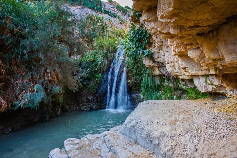
Ein Gedi (pop 520)
Nestled in two dramatic canyons that plunge from the arid moonscape of the Judean Desert to the shores of the Dead Sea, Ein Gedi is one of Israel’s desert oases.
The area stretches for 6km along Rte 90, with separate turn-offs for the following places, from north to south: Ein Gedi Nature Reserve (this is the turn-off to use for the oases of Wadi David and Wadi Arugot, the Ein Gedi Youth Hostel and the Ein Gedi Field School), Ein Gedi Beach (1km south of the reserve), Kibbutz Ein Gedi (3km south of the reserve) and Ein Gedi Spa (6km south of the reserve).
Ein Gedi Nature Reserve. A paradise of dramatic canyons, freshwater springs, waterfalls and lush tropical vegetation (come wearing your swimming costume) that consists of two roughly parallel canyons, Wadi David and Wadi Arugot, each of which has its own entrance complex and ticket office.
Ancient Synagogue. Situated about midway between the Wadi David and Wadi Arugot ticket offices, this 5th-century AD synagogue sports a superb mosaic floor decorated with the 12 signs of the zodiac.
Ein Gedi Beach. This hugely popular but unpleasantly stony public beach (bring plastic flip-flops) fulfils the bare requirements of those seeking a Dead Sea float in that it has toilets and changing rooms (per entry 2NIS) and a towel (10NIS).

It’s possible, but not so convenient, to explore the Dead Sea by public bus. Egged buses (www.bus.co.il) link sites along Rte 90 (including, from north to south, Qumran, Ein Feshkha, Metzukei Dragot junction, Mineral Beach, Ein Gedi Nature Reserve, Ein Gedi Beach, Kibbutz Ein Gedi, Ein Gedi Spa, Masada.
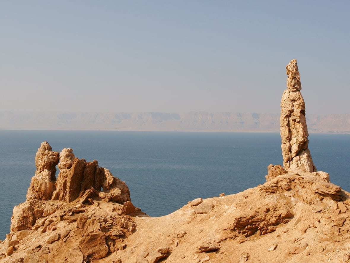
Mount Sodom (Jebel Usdum) is a hill along the southwestern part of the Dead Sea in Israel, part of the Judean Desert Nature Reserve. Mount Sodom began its rise hundreds of thousands of years ago and continues to grow taller at a rate of 3.5 millimetres (0.14 in) a year. Movements of the African rift system, along with the pressure generated by the slow accumulation of earth and rock, pressed down on the layers of salt, creating Mount Sodom. It is about 80 percent salt, 720 feet (220 m) high, capped by a layer of limestone, clay and conglomerate that was dragged along as it was squeezed up from the valley floor.
It is approximately 8 kilometres (5 mi) long, 5 kilometres (3 mi) wide, and 226 metres (742 ft) above the Dead Sea water level, yet 170 metres (557 ft) below world mean sea level. Because of weathering, some portions have separated. One of these pillars is known as “Lot’s wife”, in reference to the Biblical account of the destruction of Sodom and Gomorrah.
Dan is a city mentioned in the Hebrew Bible, described as the northernmost city of the Kingdom of Israel, and belonging to the tribe of Dan. The city is identified with a tell located in northern Israel known as Tel Dan. Dan is situated in the area known as the Galilee Panhandle. To the west is the southern part of Mount Lebanon; to the east and north are the Hermon mountains. Melting snow from the Hermon mountains provides the majority of the water of the Jordan River, and passes through Dan, making the immediate area highly fertile. The lush vegetation that results makes the area around Dan seem somewhat out of place in the otherwise arid region around it. Due to its location close to the border with Syria and Lebanon at the far north of the territory which fell under the British Mandate of Palestine, the site has a long and often bitterly contested modern history, most recently during the 1967 Six-Day War.
The Tel Dan Nature Reserve was first declared on 39 hectares surrounding the tel in 1974. 9 hectares were added to the reserve in 1989. The Dan River is one of the three water sources of the Jordan River that meet in the northern part of the Hula Valley.
MASADA
History. Almost all historical information about Masada comes from the 1st-century Jewish Roman historian Josephus. Josephus writes that the site was first fortified by Alexander Jannaeus in the first century BCE. Herod the Great captured it. Masada was the first site Herod the Great fortified after he gained control of his kingdom. Masada was the built in three building phases in 35 BCE, 25 BCE (Northern Palace continues two levels down, over the end of the cliffs) and in 15 BCE (entire site of Masada – except for the Northern Palace – was enclosed by a casemate wall, a double wall with a space between). It survived the siege of the last Hasmonean king Antigonus II Mattathias. In 66 CE, a group of Jewish rebels, the Sicarii, overcame the Roman garrison of Masada with the aid of a ruse. After the destruction of the Second Temple in 70 CE, additional members of the Sicarii fled Jerusalem and settled on the mountaintop after slaughtering the Roman garrison. According to Josephus, the Sicarii were an extremist Jewish splinter group antagonistic to a larger grouping of Jews referred to as the Zealots, who carried the main burden of the rebellion. Josephus said that the Sicarii raided nearby Jewish villages including Ein Gedi, where they massacred 700 women and children.
In 73 CE, the Roman governor of Iudaea, Lucius Flavius Silva, headed the Roman legion X Fretensis and laid siege to Masada. The Roman legion surrounded Masada, and built a circumvallation wall and then a siege ramp against the western face of the plateau. The 375-foot (114 m) high assault ramp consisted mostly of a natural spur of bedrock. The ramp was complete in the spring of 73, after probably two to three months of siege, allowing the Romans to finally breach the wall of the fortress with a giant siege tower and a battering ram moved laboriously on April 16. The Romans employed the X Legion and a number of auxiliary units and Jewish prisoners of war, totalling some 15,000 troops. Originally, Jewish rebels on top of Masada threw stones at those building and constructing the ramp. When this plan was realized, the Romans put captured Jewish prisoners from previously conquered towns to work the ramp. The Jewish people on top of Masada stopped killing those who built the ramp, choosing not to kill their fellow Jews, even though they understood this might result in the Romans penetrating the fortress. According to Josephus, when Roman troops entered the fortress, they discovered that its 960 inhabitants had set all the buildings but the food storerooms ablaze and committed mass suicide or killed each other. Only two women and five children were found alive. There are significant discrepancies between archaeological findings, and Josephus’ writings. Josephus mentions only one of the two palaces that have been excavated, refers only to one fire, while many buildings show fire damage, and claims that 960 people were killed, while the remains of only 28 bodies have been found.
Masada was last occupied during the Byzantine (Eastern Roman Empire) period of rule, when a small church was established at the site.[
In 1842, American missionary Samuel W Wolcott and the English painter W. Tipping were the first moderns to climb it. Due to the remoteness from human habitation and its arid environment, the site remained largely untouched by humans or nature for two millennia.
These days, Masada is guarded by the massive visitors centre, home to the superb Masada Museum (a really excellent introduction to Masada’s archaeology and history). Masada was declared a UNESCO World Heritage Site in 2001.

How to Get Up: 1. Snake Path. This famously serpentine footpath winds its way up Masada’s eastern flank, starting from near the visitors centre. It gains approximately 300 metres (980 ft) in elevation. A dawn hike is considered part of the “Masada experience”. Hikers frequently start an hour before sunrise, when the park opens, to avoid the mid-day heat, which can exceed 43 °C (109 °F) in the summer. 2. Ramp Trail. Ascend Masada from the west side via this Roman-built trail, accessible only from Arad (it’s a 68km drive from the visitors centre via Rte 31 and then Rte 3199). or 3. Cable Car. (adult return/up only/down only incl admission fee 72/54/27NIS) Whisks you from the visitors centre to the top in Swiss comfort in just three minutes.

The Roman attack ramp still stands on the western side and can be climbed on foot. Many of the ancient buildings have been restored from their remains, as have the wall-paintings of Herod’s two main palaces, and the Roman-style bathhouses that he built. The synagogue, storehouses, and houses of the Jewish rebels have also been identified and restored. The meter-high circumvallation wall that the Romans built around Masada can be seen, together with eleven barracks for the Roman soldiers just outside this wall. Water cisterns two-thirds of the way up the cliff drain the nearby wadis by an elaborate system of channels, which explains how the rebels managed to conserve enough water for such a long time.
Inside the synagogue, an ostracon bearing the inscription me’aser cohen (tithe for the priest) was found, as were fragments of two scrolls; parts of Deuteronomy 33–34 and parts of Ezekiel 35–38 (including the vision of the “dry bones”), found hidden in pits dug under the floor of a small room built inside the synagogue. In other loci, fragments were found of the books of Genesis, Leviticus,Psalms, and Sirach, as well as of the Songs of the Sabbath Sacrifice.
In the area in front of the northern palace, eleven small ostraca were recovered, each bearing a single name. One reads “ben Yair” and could be short for Eleazar ben Ya’ir, the commander of the fortress. It has been suggested that the other ten names are those of the men chosen by lot to kill the others and then themselves, as recounted by Josephus.
The remnants of a Byzantine church dating from the 5th and 6th centuries have also been excavated on the top of Masada.
The Chief of Staff of the Israel Defense Forces (IDF), Moshe Dayan, initiated the practice of holding the swearing-in ceremony of Israeli Armoured Corps soldiers who had completed their Tironut (IDF basic training) on top of Masada. The ceremony ended with the declaration: “Masada shall not fall again.” The soldiers climbed the Snake Path at night and were sworn in with torches lighting the background. This ceremony is now held at Latrun, outside Jerusalem.
Some observations on Israel
Level of English. I expected that everyone in Israel spoke English. But the level of English is little better than in China. However English ability improves considerably in Tel Aviv and Jerusalem. Shopping in a grocery store is worse than in China. Everything is in Hebrew and Hebrew script (which is more difficult to decipher than Chinese characters). Store names, bus announcements and bus tickets are all in Hebrew with no English at all (in China everything is repeated in English on trains and planes and tickets are bilingual). Highway signs are in Hebrew, Arabic and English.
Friendliness. The first question they ask is “Do you like Israel?” Israelis think they are the friendliest people on Earth, but they are delusional. Maybe if you are an Israeli Jew or speak Hebrew, but generally they are impatient, short and on the rude side. Of course this is a generalization, but compared to Tunisia, Lebanon, Jordan, Central Asia, or China, they are not friendly.
And issues of controversial politics go nowhere. None have read the “Ethnic Cleansing of Palestine” and dis it immediately “That isn’t true.” That is one opinion and you need to look for the other side”. Israel has more propaganda than most places and history books have been wiped clean. I was purposely trying to be controversial without offending them. But they actually seem to think that they are doing the Palestinians a favour by allowing them to coexist in their country.
Sunday mornings in bus depots are a zoo. All the young Israelis go home on Thursday or Friday for Shabbat, then return to their bases on Sunday. The Be’er Shiva bus station was packed, about 90% were in the army. Most had M-16s slung over their shoulder. They ride the buses for free and be careful about obtaining bus reservations if you want to travel on these days. It was easy to go to Masada as no one lives there.
I stayed at Masada Guesthouse, an HI hostel and the only one at Masada. It is booked daily by school groups and there are hundreds of 14-year-olds rotating through every day. They are unbelievably noisy and out-of-control. The food is very good. My room mate is Henry, a Canadian in his late 60s from Quebec who has led a fascinating life. He worked for John Lennon in the early 70’s and his daughter works for Diana Krall. He is a Buddhist and into mystical religions, travel, producing videos of his destinations and exposing the cults of Scientology, Jehovah Witnesses and the LDS church.
We went south to the big spa/hotel complex. It had rained all morning and the roads had small streams crossing them (there are no culverts), so there was a road block at the outskirts of the “town”. We wandered through one of the hotels full of Russians in bath robes, but then were prevented from returning by a guy who spoke zero English and we could not make him understand that we were staying at Masada and needed to return. After 4 hours, a policeman appeared who spoke English and we were finally able to cross the barricade. It hadn’t rained the whole time and the water had disappeared. But we were prevented from heading north to Qumran (the site where the Dead Sea Scrolls were discovered) and Ein Gedi to see the ancient synagogue and Nature Reserve. Masada was also closed until the afternoon and it was too late to go up.
I continue to talk to Israelis about their country and finally met some very open-minded tour guides who were a joy to talk to. Nobody has even heard of “The Ethnic Cleansing of Palestine” but they actually believed that the atrocity had occurred. Most Israelis are ignorant of their history and very defensive about their existence in a sea of animosity. Israel is all they have and everyone hates them. They had traveled after leaving the army but 99% of young Israelis return to Israel. They all want peace and an end to the Palestinian conflict but see nothing happening for generations. They talked about their grandparents who started the country, their parents who built the country and how their generation had been given everything by indulgent parents and were basically spoiled and entitled. The kids they guide are rude, disrespectful and only here to raise hell in their one road trip of the year.