
MONASHEE MOUNTAINS
The Monashees stretch 530 km (329 mi) from north to south and 150 km (93 mi) from east to west.
SHORT TRAVERSES
Blanket Mountain to Avalanche Lake
Okanagan Traverse
GRAND TRAVERSES
Gold Range
Monashees by Ski 600 km
BOUNDARIES
The Monashees are bounded on the east by the Columbia River and Arrow Lakes, beyond which lie the Selkirk Mountains, and the Canoe River (Canoe Reach on Kinbasket Lake). On the west, they are bounded by the North Thompson River and Adams Lake on the Interior Plateau. The northern end of the range is at the southern end of the Robson Valley, just south of the town of Valemount. They extend southward across the Canadian Pacific Railway at Eagle Pass (561m) as far as the southern end of Upper Arrow Lake. To the south, the western boundary is Okanagan Lake, although the alpine region is not nearly so vast.
The southern end of the Monashees within Canada is a historically significant mining and former industrial area known as the Boundary Country, which is focused around the basin of the lower Kettle River and extends north toward the Midway Range. In the south, the Monashees extend into Washington State (Kettle Range) as relatively low ranges. In this, they are similar to all the ranges of the Columbias – the most significant uplift is always towards the north.
The name is Monashee is Gaelic and means mountain of peace.
The most significant uplift is concentrated east of the North Thompson River. The highest point is 3250m. Parts of the range have extensive snowfields and glaciers, up to about 5 kilometres in length. They are heavily forested up to about 1600 metres. Near the timberline, there is a dense cover of “buckbrush” or “snowbrush”. Heather-covered alpine, dotted with numerous lakes, is a feature of the central Monashees. Trails are few, and most of those shown on old maps are overgrown. Consequently, access is difficult.
The general arrangement of the range consists of a backbone of water-parting, from 15- 30 km west of the Columbia River, with parallel spurs branching east or southeast. The mountains rise to 2750m and above, while the river averages little more than 460m. Prominent peaks are scarce for such an extended array of mountains, and those rising above 3000m are only in the far north.
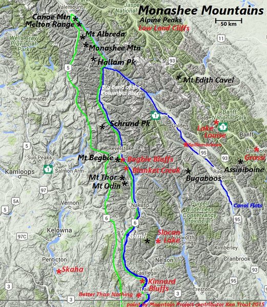
Monashee R. – green line. Columbia River – blue. Some Rock climbing locations – red
GEOLOGY
During the mountain-building compressions that formed the Selkirks and Canadian Rockies, the younger rocks of the latter were thrust up and over the gneisses of the Monashees. Erosion then exposed the older rocks.
There is evidence that these gneisses extend east continuously under the Selkirks, Rockies and the plains to the Canadian Shield (a similar mass of gneisses and granites) in Ontario.
Aside from the Coast Range and the northern Rockies, the Cariboo and Monashee Ranges are the most isolated in BC.
RANGES
NORTHERN MONASHEES. North of the Canadian Pacific Railway and the Trans-Canada Highway. Has four clusters of mountains. This area is not part of the West Kootenay.
Malton Range. This small northernmost group includes Mount Thompson and Canoe Mountain. The highest peak, in the north, is just over 2740m.
Dominion Group. It is the most northernmost and best reached from Gosnell, by way of Monashee Creek and the Lempriere Glacier. It is a region with much ice and snow south of the main summits. The peaks themselves are not rugged.
Hellroar Group. To the west, centred on Hellroar Creek, is this small strip separating the Dominion Group and the Scrip Range.
Scrip Range. Bounded in the north by Hallam Peak, 35 km east of Mud Lake and 18 km NW of Mica Dam. On the south is Pettipice Pass, separating the Seymour Arm of Shuswap Lake from LaPorte on the Columbia River. Gordon Horne Peak dominates the south.
Jordan Range. Lies south of Pettipiece Pass and north of Eagle Pass, occupied by the railway and highway. Eagle Pass was discovered by Moberly in 1865. The most visible peak is Frenchman Cap, seen best from Downie Creek to the north.
The Dominion Group and Scrip Range are composed principally of high-grade metamorphic rocks: schist, gneiss, and pegmatite. The Jordan Range is of granite gneiss, minor quartzite, and marble. Granite gneiss forms firm rock and huge slabs east of Perry River, between Big Eddy and Copeland creeks. Quartzite is prominent on the hills on either side of Hiren Creek.
Rainbow-Jordan Wilderness (Interior Temperate Rainforest in the Jordan Range of N Monahees)
SOUTHERN MONASHEES South of Eagle Pass (CPR and Trans-Canada Highway).
Gold Range. Although formerly applied to the entire Monashee Mountains, it now refers only to the range south of Eagle Pass extending to the 900m pass connecting Sitkum Creek (into Sugar Lake) with South Fosthall Creek (into Upper Arrow Lake). Good rock climbing on gneiss and granite is in the southern Gold Range and Mt Begbie in the north.
The rocks of the Gold Range are much older than the Valhallas. Both are termed gneiss complexes. The rock of both has been mistaken for granite and, although some granite is present, most of these mountains are composed of gneiss (pronounced “nice”). The origin of gneiss, a metamorphic rock, is usually from sedimentary rocks such as the rocks in the Canadian Rockies, which have been altered by high pressures and temperatures due to deep burial, and then by deformation in mountain building movements which involve compression. In the core of this mass, there were high temperatures and near-melting conditions. The result is a rock that is foliated (mineral crystals aligned or segregated in bands), but which often resembles granite to the untrained eye. Quartzite and marble, (metamorphic rocks), are present in the upper part of Mount Begbie. These two, respectively, are sandstone and limestone which have been subjected to metamorphism. They were originally sedimentary. The age of the rocks is 2.1 billion years, among the
oldest in North America and four times the age of the rocks at Glacier, BC.
Whatshan Range. This isolated group is of low altitude but rises well above its surroundings. They are prominent from Highway 23, north of Nakusp. The main cluster is 30 km south of Mount Fosthall.
Christina and Rossland Ranges.
Kettle Range. Bordered on the east by the Columbia River, on the west by the Kettle River, the Curlew Valley and the San Poli River. Its north boundary is immediately north of the Canada-USA border, at Grand Forks, British Columbia, extending 110 miles (177km) south to the bend of the Columbia River and Lake Roosevelt formed by the Grand Coulee Dam. The Okanagan Highlands are adjacent to the range on the west and the Selkirk Mountains are adjacent on the east. The main feature of the range is the Sherman Pass Scenic Byway that traverses the Kettle Crest.
