
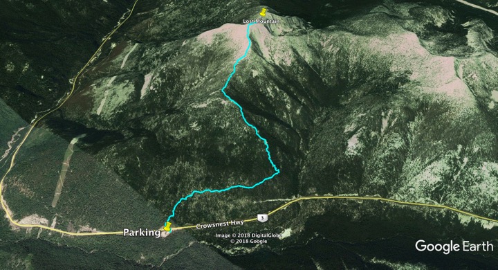
This was an uncommonly used trail to a mountain few thought of going to. But in 2017, the trail was almost completely rebuilt – new parking, trailhead, and in the first 2 kilometres, switchbacks were added to steep sections. Parking is ideal on a major highway open year-round.
But it is a lot of vertical through the woods, which creates many blowdowns. Lasting views don’t appear until a ridge near the summit. This trip is often described as an “interminable death march” and “what a grunt”. There is a much better effort-to-reward value on many other hikes. Good for fitness.
Rating: ♦♦◊◊◊
Location: Off Highway 3 between Salmo and Creston (Kootenay Pass)
Difficulty: D1 very strenuous
Elevation Gain: +1109m / 3638′
Key Elevations: Highway 3 parking: Summit
Distance: 5.3 km one way
Time: 5-7 hours
Season: Mid-June through September
Access: Excellent. Park right on a major highway. Access year-round.
Map: 82F/3 Salmo
Drive: Head east from Salmo on Highway 3 towards Creston. The parking area is a large pullout just after the avalanche gates on the highway. It has a kiosk. The trailhead is across the highway, angling left up the slope.
Trail. Cross the highway and start climbing steadily on the well-graded trail.
2.3 km. A rock outcropping with the first good views. As you ascend, the trail slowly opens up on the ridge. The trail becomes fainter. Turn left about 200 m along the summit ridge. A marker needs to be placed here to avoid being lost on Lost Mountain.
5.3 km. The summit – 3 hours.
Return in about 2 hours.
References:
https://salmovalleytrailsociety.org/lost-mountain-trail/
