
DRINNON / GWILLIM TRAIL to GWILLIM BASIN
This is one of the premier hikes in the West Kootenay – wilderness, few visitors, awesome scenery, 3 campgrounds, short enough to be a day hike but warrants several days, and challenging mountains to climb. Open fires and pets are not allowed in this trail corridor.
Rating: ♦♦♦♦♦
Difficulty: C1
Elevation gain: 701m (2300 ft); 146m (480 ft) loss
Key elevations: TH 1615m (5300ft); Drinnon Lake 1950m (6400′); Drinnon Pass 2225m (6780′); Gwillim Lakes 2171m (7120′); Summit Lucifer
Distance: 5.8km one-way
Time: 8 hours round-trip
Season: Late June through mid-October
Access: Low clearance 2 WD until last 2.5kms – 4WD high clearance where the road is washed out. Trees are overgrown with scratches to vehicles likely. Very popular trail in 2020 and often no parking at the Drinnon lot.
Map: 82F/13 Burton
Drive: To access the southern Valhallas, drive south from New Denver or north from Playmor Junction (between Nelson and Castlegar).
From New Denver. Start at the Petro Canada Station at the junction of Hwys 6 and 31A in New Denver. Drive Hwy 6 south, along Slocan Lake’s east shore, 32.5km to the village of Slocan. Near the village, ignore the signed turnoff for Drinnon Pass, but turn right (west) onto Gravel Pit Road. Zero odometer 0.0
0.0 Start west on Gravel Pit Road. Go straight and cross the bridge over the Slocan River.
.8km Stay left on Slocan West FSR.
1.2km Cross a bridge over Gwillim Creek.
2.3km Go right on Little Slocan FSR.
13.2km Right is Bannock Burn FSR to Gimli Ridge / Mulvey Basin TH.
Bear left SW on the main road for the rest of the Valhallas.
20.3km Right is Hoder Creek FSR to Drinnon and Gwillim lakes. Left continues southwest on Little Slocan FSR. Reach Little Slocan Lakes FS campground in 200m.
From Nelson or Castlegar. Start at the Playmore Junction, the junction of Highways 6 and 3A between Nelson and Castlegar. Turn north on Hwy 6 up the Slocan Valley.
The southern Valhallas are accessed from Passmore Road, 15.6 km from Playmore. there is a large transformer station at the turn. This is 12.1 km south of Winlaw on Hyw 6. Turn left (west). Zero odometer.
0.0 Start NW on Passmore Upper Road.
.3km Cross the Passmore Bridge over the Slocan River.
3.1km Pavement ends
3.6km Left on Little Slocan FSR. Red 44 KM sign.
5.2km Right.
7.5km Go straight on the main road.
9km Stay right, following a sign for Valhalla Provincial Park.
13.2km Straight on Little Slocan FSR. Left is Koch Creek FSR to McKean Lakes.
16.1km and 23km Proceed straight.
25km Go straight. Turn off to the right for Little Slocan Lakes campground.
25.2km Junction for Hoder Creek FSR – left to Drinnon/Gwillim Lakes. This is 20.3km from Slocan City.
0.0 Hoder Creek FSR
5.8km Continue straight. Right goes up Gasca FSR and Mt Rinda.
6.5km, 10.3km, and 10.6km – bear right and 18.5km stay left. Stay on the main road at all these junctions.
18.8km Stay right. The last 2 km is extremely rutted and rough, requiring 4WD high clearance. The road was brushed back in 2024 which allows for some manouvering to avoid the worst of the ruts. Cars often park along this section of road when they abandon the attempt. At least, paint damage is less likely.
21.3 km TH for Drinnon Lakes / Gwillim Lakes Trail. 1615m (5300ft).
Trail: At the trailhead, visit the outhouse – Gregorio is framed perfectly in the window.
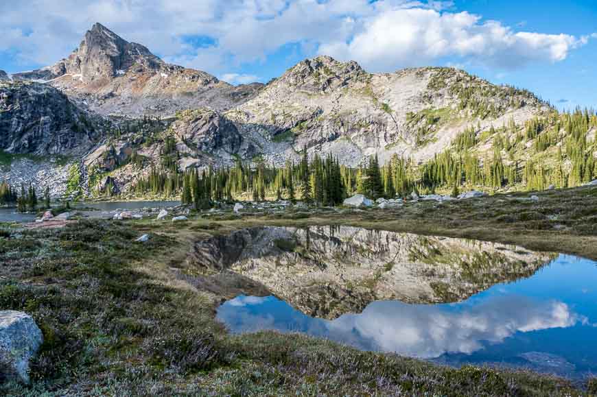
2km One hour on a good trail to Drinnon Lake at 1950m 6400′. The view of the Devil’s Range framed at the end of the lake is spectacular. 4-tent pad campground and outhouse. Cross the outlet creek and climb 116m (380′).
3.5km Drinnon Pass and Wicca Lake 2225m. 4-site campground and the Valhalla PP border. If accessing the Devil’s Range, leave the trail just before Warlock Lake and descend down to Gwillim Creek (bushwhack, game trails and a boulder field).
The main trail descends 146m (480′) to cross the headwaters of Gwillim Creek 1921m (6300′). Then ascend the final 250m (820′).
5.8km Gwillim Lakes Basin 2171m. 2.5 hours. 8 tent pads scattered to the right in the boulder-strewn alpine meadow. Outhouse and food cache, communal cooking area and waste water drain. There are two bigger lakes in the lower basin, a small lake NW and 250′ higher and two upper lakes 440 feet higher. They are on the way to the Black Prince/Lucifer Col (Lucifer Pass).
THINGS TO DO from Gwillim Basin.
1. Lucifer Pass 2585m (8480ft)
The Black Prince – Lucifer col is located due north of the basin. There is no trail but one is not necessary in the subalpine. This is the start of all south-to-north traverses of the Valhallas. Views to the north: Mt Bor, Rocky and Hird Lakes.
Distance: 1.5km one-way from Gwillim campground
Elevation gain: 415m (1360 ft)
Time: 3 hours round trip
From the campground, follow the path around the SE side of the main lake, curve north and ascend to the right of the waterfall, go past the upper lakes.
2. Climb Mountains – six mountains surround the basin (elevation gains from the main lakes):
Gregorio (class 4) East face is climbed from Drinnon Pass – 1542′
Drinnon (class 4) North face is climbed from Drinnon Lake – 1444′
Black Prince (class 3) – 2067′
Lucifer – East Ridge (class 3) – 1936′
Mephistopheles/Rosemary’s Baby/Trident – 1837′. The Devil’s Dome – Mephistopheles col is easily accessed from the basin. These three mountains are an easy continuous ridge that can only be accessed non-technically from their east end.
Mt Bor/Buri (class 4) – 2067′ via Lucifer Pass, contour high.
3. Traverses
Valhalla Traverse. Spend 4 to 7 days backpacking the spine of the Valhallas. Multiple exit points, most are east to Slocan Lake.
Drinnon Lake to Mulvey Basin.
Devil’s Range. Gwillim to Coven Lakes; climb all the peaks.
Gwillim Basin to Mt Woden and McKean Lakes.
