
GIMLI PEAK (GIMLI II) 2806m 9206′
Gimli is both the premier rock climb and hikeable summit in the West Kootenay. This magnificent, many-faceted summit rises above the southwest side of the largest Mulvey Lake.
Gimli was the new hall of the Norse gods in the time of rejuvenation, after the destruction of Odin and the old gods.
The most common route into Mulvey Meadows is via the Gimli-Nisleheim col (watch for steep snow and ice).

1. East Ridge. Although this east ridge steepens with elevation, no rope is required under good conditions. Time, 3 hours to the top. (II,3,s).
FA HB, DD, KD, MS, PW, 1, 1963.
This is the only non-technical route—approach by the Gimli Ridge trail. Cross to the right under the immediate small cliff bands to a short 3m section that is easily climbed. If this is not used, continue under the cliff bands to a narrow gully in the middle of the cliffs, a much longer route. Stroll up the grassy slopes, walking around the end of the above gulley. Access the east ridge. Follow a minimalist hiker-made “trail” up the ridge to the summit.
Ancient approaches to Gimli’s east ridge and Gimli Ridge were from Robertson Creek (as in Whipple’s descriptions dating to before the 70s). Go over the col south of Wolf’s Ears and down 150 meters in a narrow gully to talus-strewn meadows in the Gimli-Wolf’s Ears cirque; then 0.8 km to the base of the ridge.
From Mulvey Lakes, ascend to the Wolf’s Ears, cross the ridge on the west side of the ears, descend and traverse to the main ridge forming the right-hand side of the central gully. Alternatively, ascend to the Midgard/Niselhiem col, cross the glacier to the Niselhiem/Gimli col, and ascend the cliff on the easy trail (but often requiring crampons, especially late in the season).
Another error in Whipple is to approach via the gulley. “If it is desired to climb the east ridge on Gimli (Route 1), do not go beyond tree line on the trail. At treeline, traverse horizontally to the right across sloping meadows to the wide valley between Gimli and Wolf’s Ears. (One can traverse high under Gimli, but it involves altitude loss and encounters a hidden cliff band and steep side-hilling. The band can be passed, but it is not worth the danger.) Then ascend snow and talus to the east ridge.”
The east ridge (Route 1), the south ridge (Route 4), and Routes 5 – 10 are approached from the road up the north fork of Bannock Burn Creek.
2. Northeast Ridge. Pass Mulvey Lake on the north side, reach the glacier and traverse onto the northeast
Pitches 1-2. Grassy rock.
Pitch 3. Steeper, good climbing.
Pitches 4-6. Ascend broken ledges and corners of the gully system on the north face about 10 meters west of the northeast ridge.
The next five to ten pitches are a very few meters to the left of the ridge, and are easy to moderate. The final pitch is a 2.5-meter overhang with good holds. The FA party traversed onto the east face near the summit, which is easier.
Pitons, including angles, and hexcentrics up to #7 were used for protection: ice, Glacier (III,5.6,s).
FA Gerry Brown, Frank Tarver, 4/8/1969.
3. East Face. From the northeast ridge (Route 2), traverse south onto the east face (Class 5.0) about one-third of the way up the face, then continue straight up. The east face is Class 4, except for the last pitch, which is Class 5.
Ascent, 7 hours. Descent was by Route 1. Ice, Glacier (III,5.3,s).
FA Doug Fosdick, Chris Kopczynski, 6/8/1971.
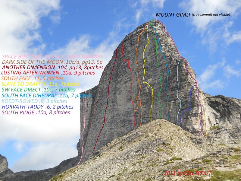
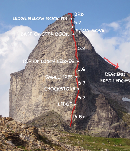
4. South Ridge. From the Wolf’s Ears, the convex south ridge is a prominent feature, and it is another outstanding route in the Mulvey Group. The climb takes the crest of the ridge. Peter Rowat, a pioneer of the climb, got stormed off. For the approach, see Route 1 and the introduction.
Pitch 1. Jam a crack at the back of a 40-meter, steep, wide chimney capped by an overhang. Exit right to a stance beside the overhang (well protected by nuts, 5.8).
Pitch 2. Go straight up for 2 meters, then back left onto the ridge crest, and climb easier rock to the first notch (5.7).
Pitch 3. Go up to a prominent flake, aim for an obvious crack, but traverse around a corner to the right. Continue up with little for the hands (5.8).
Pitch 4. Ascend to a big flat step (5.6-5.7).
Pitch 5. Continuous Class 5.6 rock for 60 meters (stance at 15m).
Pitch 6. Climb up underneath an overhang and then go left. Reach up over the left-hand edge of the overhang to a good bucket hold, followed by an orangutan move (5.8).
Pitches 7-10. Class 3-4 slabs lead to the summit. Beware of black lichen, which is slippery when wet.
Protection used was six pitons, from small horizontal to 4 cm, and 12 nuts.
One may rappel to the east halfway up for an emergency exit. (IV,5.8,**).
FA James Hamlin, Peter Koedt, 9/9/1973.
Alternate Start #1. If one follows the bottom of the southwest face toward the south ridge, one will be forced to descend abruptly about 100 meters short of the start of the climb. At this breakover point, climb a double crack (an extensive stem, 5.7 to 5.9 depending on one’s height) for 6 meters and then diagonal up and right into the obvious gully-chimney which intersects the ridge at the significant step halfway up. This avoids the first four pitches but is full of loose flakes. FA Peter Koedt, Scott Rowed, July 1977.
Alternate Start #2. About 45 meters up from the edge of the ridge (to the left looking up), there is a long diagonal chimney-like crack (60m). Please make sure to ascend it; the bottom is the most difficult (Class 5.3), and go around the overhang at the top. A few balance moves lead to the first notch. This shortens the climb considerably.
FA Steven Horvath, Pat Taddy, 8/1977.
5. Northwest Ridge (String of Diamonds). From the Gimli-Nisleheim col, walk 100 meters south to where a grand diagonal ledge (the Big Step) abuts the west face, two hours from the lower
Gain the top of the ledges either via a chimney (5.4) or a short face (5.6; unprotected). Then follow an obvious joint between the ledge and face to the top of the Big Step. This starts curving up and left on the west face to join the northwest ridge. From there, climb the edge of the north face, very exposed, immediately next to the ridge crest, two full pitches of Class 5.7 rock. The last two pitches are easy Class 5, with a steep finish.
Carry chocks and a few pitons. (III,5.7,**).
FA Steven Horvath, Derek Moule, 22/8/1983.
Variation: At the foot of the northwest ridge, traverse an easy ledge out onto the north face to near the deep couloir. After two pitches on the face of the right (5.6-5.7), climb a strange but functional chimney between the main wall and its “outside” (stemming; Class 5.7) to join the original route.
FA Fred Beckey, Cliff Leight, Dan Waters, 12/8/1988.
6. West Buttress (Space Buttress). This line lies on the dividing buttress between the west and southwest faces – two crack systems with some blank sections. There is a large notch directly above. (V,5.11+, A2).
FA Mirek Hladik, David Lussier, Dan Mack, 2001.
If one has to rappel off, there is a hard sidewise section where one has to pull the other to the anchors.
Alternate Gimli Descent Route: Use the couloir on the north face between the main summit and the lower north summit. Rappel onto snow, then descend 60 vertical meters of 65-degree snow. Six more 40-meter rappels over ice and rock follow, plus some snow walking, ending next to the bergschrund and the glacier.
Route 1, the east ridge, is usually used for the descent. Do not descend directly to Mulvey Lake.
7. Southwest Face (Another Dimension). This route lies to the right of Space Buttress in several disconnected crack systems, which were then linked together. At the bottom, the climb goes up and left at first, then straight up, then a little left, back to the right, and up to the
Rope up and traverse to the base of the first prominent crack. Past the first of several hanging belays, the crack ended with a slightly overhanging flake that required some underclinging. The climbers found themselves in a corner with a short chimney, and then moved left to climb a somewhat overhanging section (0.75 Camalot used for belay). At the lip, a fall occurred, pulling the protection and resulting in an injured knee. The leader made the move on the second try, using the Camalot.
The next pitch ended in another steep flake. Instead of climbing the thin edge, Tasker placed a cam in a shallow groove, which was the line. Another fall occurred, but the cam held. Choosing a route a little to the left (crux), he found a jug hold at the top of the flake.
After a few similar cracks, they saw the top of a large corner where the route ‘Lusting After Women’ exits. A quick but tricky traverse brought them to the corner and the top. (III,5.10, A1).
FA J.T. Croston, Shawn Tasker, 30/7/2011.
The southwest face, left of the south ridge, is a maze of routes and interconnections. It is best to rely on a specialist’s guidebook, as below.
The guidebook ‘West Kootenay Rock Guide’, by Aaron Kristiansen and Vince Hempsall (Wonow Media Ltd., Nelson, B. C.), available in Nelson, describes additional routes, mostly 5.10 – 5.11, on Gimli Peak, Nisleheim Peak and Wolf’s Ears, mainly for the rock specialist and easily accessible from the Gimli Trail. None of the routes is within the cirque.
8. Southwest Face (Dark Side of the Moon). This route is best with a 70m rope, and requires cleaning only in the first 15m (moss). Go along the main hiking trail past the ‘beach’ toward the col into Mulvey Basin. After the trail descends steeply and starts to climb again, look for the obvious shallow corner crack in dark rock.
Pitch 1. Start at the shallow corner crack in the dark rock. Follow it to a bolted belay station in a shallow dish. One can rappel to a ledge at the base of the climb: 5.8, 35m.
Pitch 2. Go up the crack past two pitons to a small ledge (5m above the second piton) below a steep mossy section in the crack.
Transition left to belay at the base of a left-facing flake, which is not visible from the corner: 5.10, 30m.
Pitch 3. Start up flake, which trends right back into the corner crack. Continue past the flaring corner (crux) up steep terrain, stemming and moving toward a large alcove/chimney behind a left-facing flake. Squeeze through and up (a #4 Camelot fits perfectly at the top), and then step right to a small ledge and belay: 5.10, 65m.
Pitch 4. Move right into a left-facing corner and follow it to the top of the headwall. Continue up and slightly right through discontinuous cracks. As the angle lessens, look to the right for a prominent belay ledge below a small roof. The small gear is helpful on this pitch: 5.8, 50m.
Pitch 5. Pull through the roof and move up through slabs with small vertical sections until the ground eases, and then it’s easy fifth class to the top. 5.7, 35m. (III,5.10).
FA J.T. Croston, Shawn Tasker, 27/7/2012.
Gear: a double rack of Camalots from #0.3 to #3, one #4 Camalot, a single set of micro cams, and a complete set of nuts with a 70m rope. If using a 60m rope, the second belay can be moved up to shorten the third pitch.
9. Little South Face (Sailor Jerry). From the south side of Gimli, gain the high snowfield on the east side and climb partway up the snow. The route is threatened by a cornice in spring and early summer, and by rockfall. Follow the central corner system (wet; two bolts). At the massive roof, evade it by a mini foot ledge traversing to a right-facing corner, and the top. Five rock pitches. (III,5.10,s).
FA J.T. Croston, Cam Shute, 16/6/2013.
10. East Face (Rumble in the Jungle). Approach for Route 9: the route is left of the first three pitches, which are on excellent rock; the fourth has lots of lichen and steep, hard climbing. Then traverse right to top out. Pitch three is fantastic on good rock, but tricky gear. Five pitches of rock climbing. (III,5.10,s).
FA J.T. Croston, Cam Shute, 14/9/2013.
11. North Face – Kootenay Carnaleta
This route follows a mixed line extending down from the deep gully system in the center of the north face. The start of the route is located roughly in the middle of the lower north face, just above the pocket glacier at 2480m ASL. The first pitch features a shallow chimney feature with waterfall ice. 8 or 9 pitches. (D+, WI4, M5, 350m)
FA David Lussier, Jennifer Olsen, 6/11/2019
P1. 50m, WI 4, M1. Climb a shallow chimney feature with good ice, stemming on the left rock wall occasionally, for about 35m (WI 4) to a sloping ledge system with mixed snow and rock. Traverse right along this ledge for 20m to a piton belay just left of the thin ice sheet forming pitch 2. The length of this pitch depends on snow levels and glacial recession.
P2. 50m, WI 3+r, M3. Step right a few metres and climb up a thin ice smear overlying a 75 ° rock slab (WI 3+, runout, stubbies useful) for about 25m to another sloping ledge system. Traverse left across the sloping ledge about 15m on mixed snow/rock, then climb up and right via a dry groove (M3) for about 15m to the base of a more defined gully system. Belay on good gear in a thin crack on the right side.
P3. 30m, M3. Climb up mixed snow and rock (M3) in the gully/chimney system, passing a piton anchor on the left.
P4. 60m, M3. Continue up the gully system via dry mixed ground passing a few minor rock steps (M3) for about 30m, at which point a hanging snowfield (40-45 °) is gained. Climb up past this snowfield and belay on gear near the bottom left of the upper gully/chimney system.
P5. 30m, M1. An easier snow-filled gully pitch leads towards a great-looking ice vein in steepening terrain above.
P6. 30m, WI3, M3. Climb the super fun ice vein in gully/corner above (WI 3) to a sling belay below a steep rock wall where the gully veers left.
P7. 40m, M5. Follow mixed snow & rock up the left trending gully to where it veers right below an imposing chockstone. Climb a steep right-facing corner on the right side of the chockstone via good crack and gear (M5) to easier mixed terrain above. Belay on lower-angle terrain at the base of the upper snow couloir.
P8-9. 100m, 45-55 °. Climb the steepening snow couloir to the top and the summit plateau. A 5-10-minute walk across the plateau leads to the main summit.
Historical significance: Part of this route was surprisingly used as a rappel route during the summer of 1977 (CAJ 61: 161). A party of 3, taking part in the ACC general mountaineering camp located in Mulvey basin, rappelled down the north couloir after making an ascent of the North Ridge. They left a few piton anchors and slings in place. David and Jen saw some of them on their ascent and used one of their piton belays for rappelling.
The story: New routing in the mountains has been my passion for over 20 years. For me, this passion has grown to be just as exciting as climbing existing routes. The adventure, the puzzle, the unknown and the feeling of accomplishment are among the stimulating factors. It was always important to make sure that my passion did not become an obsession. The latter has the potential to govern your life, which is unhealthy and potentially risky. That said, even at a managed passion level, it is more dangerous to venture into the unknown and climb new routes than it is to follow a known established one. The following is an account of a recent new route established in these principles during the Fall of 2019
The appeal for this particular climb started in November 1996 when Tom Dool and I went to Mulvey Basin for an adventurous early winter ski touring weekend. It had snowed a fair amount in October up high; however, there was very little snow below the tree line, making it possible to drive a SUV to the regular Gimli trailhead at 1700m. We skied in with all our ski touring and winter camping paraphernalia. It was a beautiful, cold, early winter weekend with clear skies. There was just enough snow in the alpine to gingerly ski on planar lee terrain. We skied in the headwaters of Mulvey basin that weekend and bagged a ski descent of the regular East face route on Asgard Peak.
That weekend, we saw Mulvey Basin from a very different lens. The beautiful alpine rock walls were just as stunning, but the early-season snow cover on the nearby north-facing walls revealed ample winter mix climbing potential. There are endless options on the many north-facing gully features spanning from Mount Dag on the left to Gimli Peak on the right. The North Face of Gimli was of particular interest. It had some great-looking continuous features, making it very desirable for winter mixed climbing. The center of the upper face was bisected by a deep couloir leading down into a series of interesting mixed corners interspersed by short steep steps in an appealing line spanning down to the little pocket glacier below. We left Mulvey Basin that weekend with the realization that winter alpinism was possible here and, in fact, desirable.
Years passed, and I visited Mulvey Basin during the summer months for alpine rock-climbing countless times. Every time I got a chance to glimpse at the Gimli North face, it would bring me back to that moment, that realization. Some mountain features have a way to lure the opportunistic adventure climbers more than others, and this feature did just that. Every other Fall since then, I would scheme a plan with friends to try. It was difficult for all the elements to align, partners, avalanche conditions, weather, time off, etc. There was also the unknown factor, you couldn’t just drive up the road and inspect it from the comfort of your vehicle; you had to go right up to the base to know the conditions. Most new routes have a high degree of uncertainty; this one was no exception. Its location and associated snow climate made it more challenging to evaluate from afar.
It was the Fall of 2019 when everything finally lined up for a serious attempt. It required two attempts over one week to complete the route. We had seen a couple of good early-season snow dumps up high; however, it had been 10 days since the last storm and temperatures in the alpine were below freezing throughout. We had the perfect mix of early-season weather conditions and a strong potential partner lineup for a solid attempt. The first attempt was made on Halloween as a day trip from Nelson with fellow ACMG guide and friend Stephen Senecal. The lure of doing it light and fast as a day trip, without knowing the conditions, worked against us on this attempt. Snow conditions were very similar to the ones we encountered back in 1996. Getting to the trailhead with good snow tires and an SUV was easy. Of note, a Winter attempt would require skinning up an additional 13km along the road while gaining 1000m elevation (or snowmobiling in) to access the parking lot. There was only 30cm of snow at the trailhead, but snow increased with elevation quickly to about 100cm at treeline. From the trailhead, we skinned up 5km along the summer trail with 850m elevation gain to the Gimli col. There was just enough snow to skin up on the trail and not enough coverage to venture off-trail below treeline. We left all the touring gear at the col and continued on foot from there.
From the col, we did a 30m rappel over a rock band down the North side onto the snow slope below. We dug a satisfactory snowpack test before pulling our ropes and then starting to walk diagonally, losing about 100m in elevation, across the steep snow slope in a North-easterly direction to gain the small pocket glacier below the North face. We got to the base of the route later than anticipated, but were quite pleased with what we could see. The first pitch looked good; a beautiful 30m waterfall ice 4 (WI4) feature tucked in the back of an open chimney feature right off the glacier. We proceeded to climb this on good protectable ice, stemming occasionally on the nearby rock wall to the left. Following this, a 20m right-hand traverse across a 50-degree mixed ledge system led to a piton belay at the base of a thin-looking ice flow overlying 75-degree rock slabs. I started tackling the thin ice of pitch 2. It was already after noon by then, and we knew we had a lot of unknown terrain beyond. Also, the ice was thin, the gear was sparse, and daylight hours were limited. After trying a few different options in mounting uncertainty, I decided to bail and downclimb back to the belay. Stephen and I rapped off and slowly made our way back to the trailhead and eventually home in Nelson. I couldn’t help but think that with a bit more time and a few more stubbies (very short ice screws), I would have committed to the pitch. Self-critique was building on the walkout, but I was already scheming a return. We had learned so much about the route on our attempt, so we had to come back with a better strategy.
The second attempt and successful ascent was done with my friend and fellow guide, Jen Olsen, about a week later. Stephen had headed to the Rockies and was unable to join for the second attempt. The weather had generally been favourable between the two attempts. Jen and I decided to try it over two days and bivouac near the route before our attempt. This proved to be quite crucial in our success. We headed out the day before with all the gear, drove to the parking lot, skied in and camped near the regular summer campsite for the south ridge of Gimli. The next morning, we got up at 4 am, made a quick breakfast and headed off towards the climb. The approach was just as slow going as the previous attempt, but we had fresh legs and some knowledge of what to expect, and confidence was high. We got to the base around 6:30 am, and I offered the first pitch to Jen, which she enjoyed. We were back near the previous high point in no time, and it was my lead. It felt terrific to be back there without time pressure and more stubble to tackle the pitch. I immersed myself in the task at hand and confidently climbed through the thin ice smear overlying a 75-degree rock slab for 25m, finding small gear occasionally, to the next sloping ledge system. Yahoo! What a relief it was to have climbed that section with confidence. A short traverse left led to the beginning of the main weakness, which appeared to continue up the North Face to the summit plateau.
From there onwards, Jen and I swung leads while following the main gully feature. We enjoyed an interesting mix of climbing, primarily involving snow up to 55 degrees and multiple rock steps in the M3 range. Snow and avalanche conditions were favourable, and the gully feature was becoming progressively more defined with elevation. We encountered a very nice ice pitch on pitch 6; a fine 30m WI 3 goulotte (ice vein in the back of a corner feature). This is where Jen dropped her iPhone with all the good photos she had taken thus far. Getting past the right-hand side of a steep chockstone in the deepening gully on Pitch 7 was the crux rock pitch at M5 (mixed climbing on steep rock level 5). The last two pitches along the final couloir to the summit plateau were mainly steep snow in the 45-55 degree range.
After reaching the summit plateau on top of the couloir, we celebrated briefly and started our descent. We opted to reverse the process and rappel the route. We managed to do half of the descent in daylight but had to do the rest in the dark, thanks to the short November days! When we went to the base, we looked for Jen’s iPhone but could not find it. We retraced our steps back up and over the Gimli Col and, after switching back to ski gear, skied back to our camp after 16 hours of nonstop travel. We then packed our overnight gear and started skiing out via the summer trail in the dark. At about 2000m, we strapped the skis to our packs and walked out along the summer trail back to the vehicle, tired but very happy. We feasted on celebratory chips, beer and kombucha as we drove down the snowy road back to the safety of our home valley.
It wasn’t until the following days that the realization started to hit home for me. On top of accomplishing a great climb with good friends, I had completed a long-time project. That was super satisfying, especially since it felt like we had calculated the risk fairly accurately and that the conditions were optimal. The route name “Kootenay Canaleta” was Jen’s idea. It reminded her of the “Supercanaleta” route on Fitzroy in Patagonia, but without the international traffic. I thought it was very fitting. She added that Gimli offers a pristine setting, ‘more beautiful than the sun’, and the North face is a ‘fire-shelter’. We were lucky with perfect winter temperatures just below freezing”. Big thanks to Jen and Stephen for their contributions & camaraderie!
Equipment required (gear/rack): 8 ice screws, including a few stubbies for P2, 3-4 pitons, a set of nuts, including RP’s, Cams from 0.2” to 4”, doubles in the 0.5” to 2” range.
Ascent Time: 16 hours return from a camp. Descent Time: 2-3 hrs
Historical significance: Part of this route was surprisingly used as a rappel route during the summer of 1977 (CAJ 61: 161). A party of 3, taking part in the ACC general mountaineering camp located in Mulvey basin, rappelled down the north couloir after making an ascent of the North Ridge. They left a few piton anchors and slings in place. David and Jen saw some of them on their ascent and used one of their piton belays for rappelling.
Author: David Lussier is a Nelson-based Mountain Guide and KMC member. If you are interested in writing about your roped climbing adventures in the next On-Belay Column, get in touch with David via email at [email protected].
