
MOUNTAINS IN THE INTERIOR OF BRITISH COLUMBIA
COLUMBIA MOUNTAINS
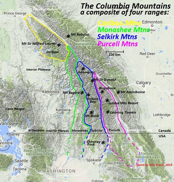
Includes the Cariboo, Monashee, Selkirk, and Purcell Mountains. For many years, this extensive alpine uplift was referred to as the Interior Ranges of British Columbia.
The Columbia Mountains are separated from the Canadian Rockies to the east by the deep Rocky Mountain Trench (in which run the Canoe, Columbia, and Kootenay Rivers) and from the Coast Mountains to the west by the broad Chilcotin Plateau region.
The Columbians are stunning mountains. Some groups in the Columbia River Gorge are famous, such as the Adamants, Sir Donald, and the Bugaboos. Beautiful lake districts exist throughout the range.
These mountains have four distinguishing characteristics.
1. Though hikers will find much to offer, the Columbias are preeminently climbing mountains, with their best offerings only accessible by the alpinist. Alpine mountaineering in North America had its birth on the peaks surrounding Rogers Pass. The granite spires of the Bugaboos are world-famous. The Battle Range, Adamants, Gothics, Starbirds, Vowells, Remillards, and Valhallas all offer excellent rock climbing. The Columbias provide a wide variety of routes on rock, snow, ice, and glacier suitable for alpinists of every taste and level of expertise.
2. Although access routes have significantly improved and helicopters allow excellent access to the alpine, those accustomed to the Alps, Tetons, and the Sierra Nevada will find many of the approaches quite arduous. These difficulties are, in part, a function of the climate. As a temperate rainforest, moist Pacific air drenches the Columbians with abundant precipitation, producing great coniferous climax forests. Unfortunately, the legendary “bush” of the Columbians, dense and luxuriant vegetation replete with slide alder and devil’s club, is a product of the same generous rainfall. Only in the well-maintained trails of the Rogers pass area and on the drier, eastern slopes of the Purcells, where conditions more nearly approximate those of the Canadian Rockies, is bushwacking not all too deplorably common. More logging and mining roads, as well as more trails, are constantly being opened; yet, older ones, which lack regular maintenance, grow over with nearly equal rapidity. Logging roads can be deactivated, washed out, or abandoned.
3. High Snowfall and Glaciers. Before the end of June, snow and avalanche debris cover alpine trains. July 15 through September 1 usually provide periods of good climbing weather. September and October can be delightful, but early snows will almost certainly cover higher elevations.
The same abundant precipitation forms the significant winter snowpack that supports many fine glaciers. There are more than 400 glaciers in Glacier National Park (BC not Montana) alone, a small bit of the Columbias. The line of permanent snow is located at altitudes of 2,700 to 3,000 meters, depending on the exposure. The glacier tongues descend to a lowest limit of approximately 1800 meters, but have all shown significant retreat since the turn of the century. A comparison of present conditions with the famous photographs of Howard Palmer, taken from 1908 to 1912, graphically illustrates this recession.
4. Few People. Much of the charm of the Columbias lies in their being relatively uncrowded – does this reflect the poor weather, mosquitoes, and difficult access? It is a fine country for exploratory mountaineering off the beaten track.
CARIBOO MOUNTAINS
The Cariboo Mountains are far north of the West Kootenay and beyond the scope of this e-book.
Boundaries: The Caiboo Mountains are separated from the Rockies to the east by the Fraser River and are bounded on the southeast by the McLennan River, Albreda Pass and the valley of the Albreda and North Thompson rivers.
The northern limit is less well-defined. Although it extends into the bend of the Fraser River, in the north, the alpine portion breaks down in the vicinity of Goat River. From here, easy passages exist to Isaac Lake and the mines around Barkerville and Quesnel, on the border toward the Interior Plateau. Bowron River and a line around the Quesnel basin to Clearwater Lakes enclose the area of mountaineering interest.
The airline distance from Albreda Pass to Goat River is 121 kilometres; the width of the range from the Fraser River to Barkerville is 78 kilometres.
Large, active glaciers with spectacular icefalls exist in the mountains of the western Halvorson Group, the northern Wells Grey Group, the Premier Ranges, the Dominion Group, and the north Scrip Range. There is good climbing on rock, snow, and ice.
A formidable barrier to the western outlet of Yellowhead Pass, the Cariboo Mountains assumed early importance during the early surveys for the Canadian Pacific Railway, conducted between 1860 and 1874; however, no clear passage was discovered.
Northernmost Cariboos. Rising to slightly under 3000m, this area of lesser summits lies west and southwest of McBride. Although some of these peaks are within Bowron Lake Provincial Park, the bulk of the more attractive summits lie east of the park and are more accessible from Castle Creek.
Maps: 93H/7 Goat River, 93H/1 Eddy, 93H/2 Lanezi Lake, 93H/6 Indianpoint Lake, 93A/15 Mitchell Lake.
Wells Gray Group. They form a wedge between the Northernmost Cariboos and the Premier Range. This group is bounded on the west by Castle Creek, Niagara Creek and the lower Clearwater River, and on the east by the Raush and North Thompson Rivers. The most significant uplift is to the north, where only three peaks exceed 2900m. North of Mount Goodall, no fewer than 15 peaks exceed 2740m, while the larger area to the south contains only about six such peaks.
The region is best reached by helicopter. The road up the NW side of Castle Creek might be helpful. Travelling near or above timberline is relatively easy, but the deep valleys and well-dissected topography make long traverses difficult, particularly in the northern section. The number of glaciers and névés attests to the frequency of cloudy summer weather.
Maps: 93A/16 Mount Winder, 93H/1 Eddy, 83E/4 93A/893A/9, 82M/12-13 (this list includes much of Wells Gray Provincial Park).
Premier Range. This range is bounded by the Albreda, North Thompson, Raush, and Fraser Rivers and lower Camp Creek, lower Canoe River, and lower McLennan River. These hydrographic boundaries become complex in the vicinity of Valemount.
The rock is predominantly mica schist, with subordinate gneiss and quartzite. Consequently, there is little technical rock climbing in the range. The snow and ice are often quite good, however. The compactness and high relief of the range, together with its accessibility (somewhat greater than the Selkirks), recommend it as a mountaineering locale. Due to the significant vertical relief, it is advantageous to camp at a high elevation.
For mountaineering purposes, the Premier Range can be conveniently subdivided into northern and southern groups by an east-west line along the Canoe River (flowing to Kinbasket Lake and the Columbia River, the North Canoe Glacier, and the Laurier Glacier, between Mounts Sir Wilfred Laurier and MacKenzie King. The Tête-à-la-Canoe pass connects these two groups, with the northern drainage mostly flowing to the Fraser River.
District Offices of the BC Forest Service are located in McBride and Clearwater, and Field Offices in Blue River and Valemount.
Maps: (north and south) 83D/11-14 – Canoe Mountain, Azure, River, Kiwa Creek, and Valemount (maps 12 and 13 are the most important).
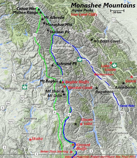
MONASHEE MOUNTAINS
They stretch 530 km (329 mi) from north to south and 150 km (93 mi) from east to west.
Only the southern Monashees are in the West Kootenay.
Boundaries
The Monashees are bounded on the east by the Columbia River and Arrow Lakes, beyond which lie the Selkirk Mountains, and the Canoe River (Canoe Reach on Kinbasket Lake). On the west, they are bounded by the North Thompson River and Adams Lake on the Interior Plateau. The northern end of the range is at the southern end of the Robson Valley, just south of the town of Valemount. They extend southward across the Canadian Pacific Railway at Eagle Pass (561m) as far as the southern end of Upper Arrow Lake. To the south, the western boundary is Okanagan Lake, although the alpine region is not nearly so vast.
The southern end of the Monashees within Canada is a historically significant mining and former industrial area known as the Boundary Country, which is focused around the basin of the lower Kettle River and extends north toward the Midway Range. In the south, the Monashees extend into Washington State (Kettle Range) as relatively low ranges. In this, they are similar to all the ranges of the Columbias – the most significant uplift is always towards the north.
The name Monashee is Gaelic and means mountain of peace.
The most significant uplift is concentrated east of the North Thompson River. The highest point is 3250m. Parts of the range feature extensive snowfields and glaciers, extending up to approximately 5 kilometres in length. They are heavily forested up to about 1600 metres. Near the timberline is a dense cover of “buckbrush” or “snowbrush”. Heather-covered alpine, dotted with numerous lakes, is a feature of the central Monashees. Trails are few, and most of those shown on old maps are overgrown. Consequently, access is difficult.
The general arrangement of the range consists of a backbone of water-parting, located 15-30 km west of the Columbia River, with parallel spurs branching east or southeast. The mountains rise to 2750m and above, while the river averages little more than 460m. Prominent peaks are scarce for such an extended array of mountains, and those rising above 3000m are only in the far north.
Geology: During the mountain-building compressions that formed the Selkirks
and Canadian Rockies, the younger rocks of the latter were thrust up and
over the gneisses of the Monashees. Erosion then exposed the older rocks.
There is evidence that these gneisses extend east continuously under the
Selkirks, Rockies, and the plains to the Canadian Shield (a similar mass of
gneisses and granites) in Ontario.
Aside from the Coast Range and the northern Rockies, the Cariboo and Monashee Ranges are the most isolated in BC.
Northern Monashees. North of the Canadian Pacific Railway and the Trans-Canada Highway. Has four clusters of mountains. This area is not part of the West Kootenay.
Malton Range. This small northernmost group includes Mount Thompson and Canoe Mountain. The highest peak, located in the north, is just over 2,740 m.
Dominion Group. It is the most northerly and best-reached from Gosnell by way of Monashee Creek and the Lempriere Glacier. It is a region with abundant ice and snow, located south of the main summits. The peaks themselves are not rugged.
Hellroar Group. To the west, centred on Hellroar Creek, is this small strip separating the Dominion Group and the Scrip Range.
Scrip Range. Bounded in the north by Hallam Peak, 35 km east of Mud Lake, and 18 km NW of Mica Dam. On the south is Pettipice Pass, separating the Seymour Arm of Shuswap Lake from LaPorte on the Columbia River. Gordon Horne Peak dominates the south.
Jordan Range. Lies south of Pettipiece Pass and north of Eagle Pass, occupied by the railway and highway. Eagle Pass was discovered by Moberly in 1865. The most visible peak is Frenchman Cap, which is best seen from Downie Creek to the north.
The Dominion Group and Scrip Range are composed principally of high-grade metamorphic rocks: schist, gneiss, and pegmatite. The Jordan Range is composed of granite gneiss, minor quartzite, and marble. Granite gneiss forms firm rock and huge slabs east of Perry River, between Big Eddy and Copeland creeks. Quartzite is prominent on the hills on either side of Hiren Creek.
West Kootenay
Southern Monashees. South of Eagle Pass (CPR and Trans-Canada Highway).
Gold Range. Although formerly applied to the entire Monashee Mountains, it now refers only to the range south of Eagle Pass, extending to the 900m pass that connects Sitkum Creek (flowing into Sugar Lake) with South Fosthall Creek (flowing into Upper Arrow Lake). Good rock climbing on gneiss and granite is in the southern Gold Range and Mt Begbie in the north.
The rocks of the Gold Range are much older than the Valhallas. Both are termed gneiss complexes. The rock of both has been mistaken for granite, and, although some granite is present, most of these mountains are composed of gneiss (pronounced “nice”). The origin of gneiss, a metamorphic rock, is usually from sedimentary rocks such as the rocks in the Canadian Rockies, which have undergone high pressures and temperatures due to deep burial, and then by deformation in mountain-building movements that involve
compression. At the core of this mass, high temperatures and near-melting conditions prevailed. The result is a rock that is foliated (mineral crystals aligned or segregated in bands), but which often resembles granite to the untrained eye. Quartzite and marble (metamorphic rocks) are present in the upper part of Mount Begbie. These two, respectively, are sandstone and limestone, which have undergone metamorphism. They were originally sedimentary. The age of the rocks is 2.1 billion years, among the
oldest in North America, and four times the age of the stones at Glacier, BC.
Whatshan Range. This isolated group is at a low altitude but rises well above its surroundings. They are prominent from Highway 23, north of Nakusp. The central cluster is 30 km south of Mount Fosthall.
Christina and Rossland Ranges.
Kettle Range. Bordered on the east by the Columbia River, on the west by the Kettle River, the Curlew Valley, and the San Poli River. Its north boundary is immediately north of the Canada-USA border, at Grand Forks, British Columbia, and extends 110 miles (177km) south to the bend of the Columbia River and Lake Roosevelt formed by the Grand Coulee Dam. The Okanogan Highlands are adjacent to the range on the west, and the Selkirk Mountains are adjacent on the east. The main feature of the range is the Sherman Pass Scenic Byway that traverses the Kettle Crest.
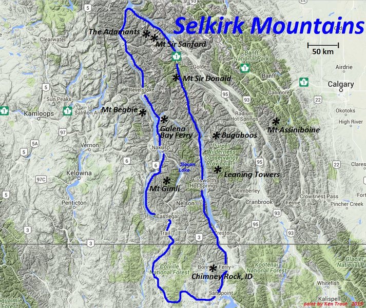
SELKIRK MOUNTAINS
Together with the neighbouring Monashee and Purcell Mountains, the Selkirk Mountains form part of a larger grouping known as the Columbia Mountains, which lie west of the Rocky Mountains.
Boundaries: The northern portion of the Selkirks lies entirely within the Big Bend, where the Columbia River makes a dramatic 180-degree turn towards the south. They extend approximately 350 km (200 miles) south to Mica Peak between Spokane, WA, and Coeur d’Alene, ID. The range is bounded on its west, north, and northeast by the Columbia River, or the reservoir lakes now filling most of that river’s course. From the Columbia’s confluence with the Beaver River, they are bounded on their east from north to south by the Purcell Trench, which contains the Beaver River, Duncan River, Duncan Lake, Kootenay Lake, and the Kootenay River in southeastern British Columbia, and the Kootenai River in Idaho.
In the USA, the Selkirks span the northwestern portion of the Idaho Panhandle and northeastern Washington. Its east-west boundaries are the same as in Canada – the Columbia River to the west and the Kootenai River to the east.
The Selkirks were named after Thomas Douglas, 5th Earl of Selkirk.
The southern end of these mountains is home to the only extant woodland caribou population in the contiguous United States.
Geology: The Selkirks are approximately 850 million to 1.5 billion years old, having once been an extremely shallow sea on the edge of an ancient continental plate. The sea received sediments from the many rivers that emptied into it. These sedimentary rocks are found in many areas to be lightly metamorphosed. One hundred million years ago, the North American plate began to move west, overriding the Oceanic Pacific plate. The denser oceanic plate was forced downward. The resulting pressure and friction liquefied the rocks, forming magma. As magma is lighter than rock, it rose toward the Earth’s surface, creating massive bodies of granite rock known as batholiths. The resulting uplifting of the Earth’s surface resulted in the formation of mountains. During these compressions, the metamorphic rocks of the Selkirks were pushed eastward over the strong gneisses of the Monashees below.
It was not until the last hundred thousand years that the last ice age covered the entire Selkirks. The 4,000-foot-deep ice cut and shaped the mountains, digging out the deep valleys. Selkirk peaks offer a wide variety of climbing and hiking opportunities, with remote summits and rock climbing.
Geography
The Selkirks are divided into two geographically separate areas. The transportation corridors for each area are also completely individual. The dividing line is Trout Lake and the Lardeau River, where it enters the Duncan River. The West Kootenay lies south of that line.
1. Selkirks North. These have much more mountaineering interest than their southern counterpart. They are not considered in this e-book. David Jones has written two excellent guidebooks to this area: Selkirks North and Selkirks South. They are further divided into a north and south section separated by the Canadian Pacific Railway and the Trans-Canada Highway.
2. Selkirks South. Extend south from the CPR and the Trans Canada Highway to Trout Lake and the Lardeau River that empties into Kootenay Lake. Some members of the Kootenay Mountain Club have explored this area.
Ranges are:
Rogers Pass Area. Rogers Pass roughly bisects Glacier National Park halfway between Revelstoke and Golden. To the North is the Hermit Range, part of Selkirk North. South of the following ranges:
Sir Donald Group. Bounded on the south and west by the Illecillewaet Neve and River, and to the east by the Beaver River. Maps: 82N/6 Blaeberry, 82N/3 Mt Wheeler and 82N/5 Glacier. It has firm quartzite that offers exceptional climbing.
Asulkan Group. This is a small group of peaks along a ridge bounded by Loop Brook on the west, the Incomappleux River to the southwest, and the Illecillewaet Neve and River to the north and east. Maps: 82N/4. The rock is good quartzite and slate.
Bonney Group. Bounded on the north by the Illecillewaet River, on the east by Loop Brook, on the south and southwest by the Incomappleux River, and the west by Flat Creek. Maps: 82N/4 Illecillewaet. Good quartzite, slate, and pockets of limestone.
Albert Group. A diverse and extensive group of peaks bounded in the west by the Columbia River, on the north by the Illecillewaet River, and on the east by the Incomappleux River and Flat Creek. Other than the peaks between Albert Peak and Charity Peak, the mountains are of little interest. Maps: 82N/4 Illecillewaet, 82L/16 Revelstoke and 82K/13 Camborne. The geology is highly diverse due to the folding, faulting, and intrusion of granite stock.
The Deville Ranges: Dawson Group, Bishops Group, Purity Group, and Sugarloaf Group that border the Deville Glacier. All the peaks in this range lie within Glacier National Park—map: 82N3 Mt Wheeler.
There are three general access routes: a traverse of the Illecillewaet Glacier, via the Beaver Valley, or the Four Passes Route.
Battle Range: Ranges are the Melville, Westfall, and Nemo Groups. The almost impenetrable bush, steep valleys, and rugged terrain stopped all but the most persistent mountaineers. Even today, despite logging roads, the final approaches through dense bush present formidable challenges.
The majority is composed of granite, some of which is firm, but most of it is fractured into many blocks, typical of alpine settings.
There are four access points from the north, but only one from the south and the West Kootenay, the Duncan Forest Service Road.
Badshot Group: Bordered on the north by the apex formed by the Incomappleux River and Boyd Creek-Westfall River, and on the south by the Lardeau River-Duncan River confluence. Maps: 82K/13 Camborne, 82K14 Westfall River, 82K12 Beaton and 82K/11 Trout Lake. The poorest rock in the entire Selkirks is rock that is rotten and highly shattered. Prospectors had probably climbed all of the non-technical summits by the turn of the century.
3. West Kootenay Region of the Selkirk Mountains. This part of the Selkirks contains the most southerly summits of the Columbia Mountains to have attracted the interest of mountaineers.
Boundaries to the north are Trout Lake and the Lardeau River, which form a large valley running southeast from Beaton on Upper Arrow Lake to Meadow Creek on the isthmus between the southern end of Duncan Lake and the north end of Kootenay Lake. Kootenay Lake forms the east boundary, and Arrow Lakes (the Columbia River) determines the western border.
The region is roughly split down the middle by the Slocan Valley, which proceeds southeast from Nakusp on Upper Arrow Lake and then south along Slocan Lake and the Slocan River, which joins the Kootenay River not far west of Nelson.
Selkirk Mtns North and East of Slocan Lake
Lardeau Range. A large area, it is bound on the west by Upper Arrow Lake, on the NE by Beaton Creek, Trout Lake, and Lardeau River, and the south by Kuskanax and Poplar creeks. Only in the SE do the peaks cluster; the rest of the area consists mainly of forest, with peaks not exceeding 2000m. Although this group is seldom visited now, many peaks were probably climbed by prospectors at the turn of the century. Maps: 82K/6 Popular Creek, 82K/12 Beaton, 82K/11 Trout Lake, and 82K/5 Leon Creek. Upper Arrow Lakes Forest Service Brochure.
Goat Range. Boundaries are Kuskanax and Poplar Creeks on the north, Seaton Creek and Kaslo River on the south, the Slocan Valley on the west, and Lardeau Creek and Kootenay Lake on the east. Maps: 82K/3 Roseberry, 82K/6 Poplar Creek, 82K/2 Lardeau, 82K/7 Duncan Lake, 82K/4 Nakusp, and 82k/5 Trout Lake.
The glaciers have undergone considerable retreat in the 20th century. There is a large, healthy glacier on the northeast side of Mt. Cooper, the only peak that exceeds 3000m. The area around Whitewater Creek, Marten Mountain, Mount Dolly Varden, and Mount Cooper is all grizzly bear habitat.
The entire area was a centre of mining exploration and activity around the turn of the century. Everything (including Mt Cooper) between the Slocan River and the Kootenay-Duncan system had been climbed before 1925.
Kokanee Range. It is separated from the Goat Range to the north by Seaton Creek and Kaslo River. Slocan Lake and Slocan River bound it on the west and Kootenay Lake on the east. The west arm of Kootenay Lake delimits the range on the south. There are several serrated ridges above 2740m that support small glaciers. The largest of them, the Kokanee, is some 5 square kilometres in area. The region features many small, scenic lakes. The relief is great, attaining 2260m above Kootenay Lake. Practically all the alpine-type peaks are included within the boundaries of Kokanee Glacier Provincial Park.
Bonnington Range. Bounded on the north by the Kootenay River, on the west by the Columbia River, on the south by the Trail/Salmo Corridor, and on the east by the Salmo/Nelson Corridor. They contain four huts, well known as part of an alpine skiing circuit.
Nelson Range. Bounded by the West Arm of Kootenay Lake on the north, Highway 3 to the south, the Salmo/Nelson corridor to the west, and Kootenay Lake to the east.
Selkirk Mtns South and West of Slocan Lake
Valhalla Range. Composed of northern and southern portions divided arbitrarily by a line running northeast-southwest between Mt Bor and Black Prince Mountain. Boundaries on the east are Slocan Lake and River, on the south by Koch Creek, on the west by Burton Creek, and the valley of the Columbia River (Arrow Lakes). Access is difficult, but the area boasts magnificent granite walls.
Maps: 82F/13 Burton, 82F/14 Slocan, 82K/4 Nakusp, 82K/3 Roseberry.
Valkyr Range. High ridges and basins with a few individual peaks and no permanent snow. Trees are found near most summits. The rock is excellent and smooth on outcroppings and faces. Valleys are steep and heavily wooded, and trails are scarce and overgrown. Maps: 82F/13 Burton, 82F/12 Passmore, 82E/16 and 82E/9.
Norns Range.
Selkirks in the USA. Bounded by the Columbia River on the west, the Spokane River on the south, and the Kootenai River on the east. The western part of Washington state has only a few mountains without trees on the summits. The eastern part of Idaho forms the Selkirk Mountains, also known as the Selkirk Crest.
In the centre of Idaho, large amounts of granite intruded, forming the large Idaho Batholith, which covers an area of 300 miles (N to S) by 100 miles E to W. The Kanisku Batholith is the foundation of the Selkirk Mountains. This batholith has since eroded into the present-day mountain terrain but is still covered by extensive amounts of exposed sedimentary and metamorphic rock.
Although the Pleistocene Ice Age began 2.5 million years ago, it was not until the last hundred thousand years that the ice moved out of BC and invaded Idaho, covering the Selkirks, Purcells, and Cabinet Mountains. The 4,000-foot-deep ice cut and shaped the mountains, digging out the deep beds of Priest, Pend Oreille, and Coeur d’Alene lakes.
While the highest point of the Selkirks reaches only 7,670 feet (Parker Peak), valley-to-summit elevation differences are nearly 5,000 feet in places, and the terrain is extremely rugged.
Two areas of significance are the Long Canyon area, west of Bonners Ferry, and the Salmo-Priest Wilderness area, near the Canadian/Washington/Idaho borders. The latter is home to both the grizzly bear and the rare mountain caribou. Both are pristine and worthy of protection on scenic, recreational, and wildlife management grounds.
PURCELL MOUNTAINS
The Purcells are a mountain range that forms the east side of the Columbia Mountains. They are much older than the Rockies, at least 1.5 billion years old, and began uplifting when the only life on Earth was simple, single-cell plants and animals. Some granite intrusions and other metamorphic rocks protrude into these mountains; the Bugaboos are a classic example. Most of the Purcells consist of heavily eroded and fractured sedimentary rock. The sediment layers are not as thickly bedded as those of the Rockies.
The Purcell Mountains were named after Goodwin Purcell, the expedition sponsor for the Palliser Expedition from 1857 to 1860. The Palliser Expedition crossed the Rockies and traversed into the Purcell Mountains when few trails and roads penetrated this rugged, isolated region of the east Kootenay.
The Purcells can be divided into two regions, the northern and southern areas. Both have distinct mountain features, making them notable to hikers.
The Northern Purcells have several summits over 3,000 m (10,000 ft.), with steep-sided valleys. Climbing most of the northern Purcell peaks requires technical skills. The hiking trails follow scenic valleys to alpine ridges, turquoise lakes, and flower-covered meadows near many active glaciers.
Southern Purcells are not as high, nor as rugged. Hiking and climbing to the summits is more accessible, and many day hikes lead to impressive mountaintops exceeding 2,400 m (7,800 ft.). Subalpine lakes, diverse forest habitats, and open basins are the primary features, with a few small glaciers nestled in the shaded mountain valleys.
Purcell Mountains in the USA. Primarily a Canadian range, the Purcells extend south across the border into Idaho and Montana. The range is located northeast of Bonners Ferry and is bounded by US-95 and US-1 on the west and the Kootenai River and US-2 to the south. The highest point in the Idaho section of the Purcells is an unnamed peak that reaches an elevation of 6,779 feet.
The range was inundated entirely by Pleistocene glaciers, which scraped away much of the range’s Precambrian rock. The Moyie River Canyon splits the Idaho section of the Purcell Mountains; it is the most spectacular geologic feature in the range.
The Purcells are managed by the Panhandle National Forest, which primarily oversees the range for timber harvesting. As a result, the range features an extensive road system and a relatively small and underdeveloped trail system. Only short day hikes are available for hikers. Roads reach the few mountain lakes. Climbing opportunities are limited to non-technical Class 1 and Class 2 ascents.
ROCKY MOUNTAIN TRENCH
This is a vast “U-shaped” glacier-hewn valley that winds north/south through the entire length of eastern BC. In the East Kootenay, this lowland valley channels both major rivers of the area, the Columbia and Kootenay rivers. At the town of Canal Flats, both major rivers pass each other within 1 km and flow in opposite directions. Early in the century and again in the 1980s, engineers invented a scheme to build a short canal to divert the Kootenay River to flow north into the Columbia River (to take advantage of all the hydroelectric dams on the Columbia). After exhaustive study and heated protests, the plans were shelved.
The widest section of the Rocky Mountain Trench is between Kimberley and Fort Steele at 27km. The narrowest part is the Windermere/Columbia Valley section, which is under 14 km wide.
Columbia River. It flows north from glacier-fed Columbia Lake to Windermere Lake. This river collects water from all the northern Purcell tributaries and continues north past Bolden. The extensive glaciation of the Purcell Mountains contributes volumes of glacial silt to the river, accounting for its scenic turquoise colour. In the Rocky Mountain Trench, the Columbia River flows through a naturally sprawling, expansive wetland in the Columbia Valley Wetlands. North of Golden at Donald, just after the Big Bend of the Columbia (where the river turns from running NW to going south towards the city of Revelstoke), is Mica Dam, the first of the hydroelectric dams on the Columbia. It backs up as the Kinbasket Reservoir.
Kootenay River. It begins its long journey from the mountains east of Canal Flats. As it flows south into the lowlands, it collects all the water from the High Rockies, the Purcells, the Rockies, and the Elk Valley. The Kootenay River widens and slows in the Rocky Mountain Trench, but stays as a tight meandering channel. Near the town of Wardner, the Libby Dam controls the river in the Koocanusa Reservoir, a combination of the Kootenay River (shared by Canada and the United States) as it meanders south into Montana. It turns north again into Canada near Creston and flows into the Creston Valley Management Area. Then the river continues north into Kootenay Lake, part of the West Kootenay region. Kootenay Lake is 110 km long and empties via the West Arm past Nelson, BC, to flow into the Columbia River at Castlegar. The Duncan River empties into the north end of Kootenay Lake. It forms the west boundary of the Purcells, separating them from the Selkirk Mountains.
At the end of the last ice age, a huge glacial meltwater lake combined the Kootenay and Columbia rivers, depositing thick sediments along its vast banks. These soil-rich but rocky banks provide much of the land for winter wildlife range and human settlement. In several places along the “Trench”, spires of alluvial hoodoos stand as picturesque vertical remnants of erosion by water. The best example of East Kootenay hoodoos is just north of the Dutch Creek bridge, south of Fairmont. These towers of partially cemented sand and gravel stand 120m (400’) high beside the highway.
ROCKY MOUNTAINS
On the east side of the Rocky Mountain Trench, the Rockies are the youngest of the interior mountains. The Rockies were formed during a time when dinosaurs roamed the Earth, approximately 100 million years ago. Lying in shallow seas of coral, the mountains are comprised mainly of white, massive limestone layers. They contain many fossil beds and deeply–cut creeks. Sedimentary and metamorphic rocks also form the Rockies.
On the western side of the Rockies, several high peaks rise from 2,400 to 3,000 m (8,000-10,000 ft.). Hikers may reach many of these prominent summits on a day trip. They require no special climbing knowledge or equipment, just stamina and occasional rock scrambling skills.
