
GUINEA Dec 22-28, 2016
Guinea was formerly French Guinea and is sometimes now called Guinea-Conakry to distinguish it Guinea-Bissau and Equatorial Guinea. Guinea has a population of 10.5 million and an area of 245,860 square kilometres (94,927 sq mi).
Guinea is a predominantly Islamic – 85 percent with twenty-four ethnic groups. French is the official language but more than twenty-four indigenous languages are also spoken.
Guinea’s economy is largely dependent on agriculture and mineral production. It is the world’s second largest producer of bauxite, and has rich deposits of diamonds and gold.
Human rights in Guinea remain a controversial issue. In 2011 the United States government claimed that torture by security forces, and abuse of women and children (e.g. female genital mutilation) were ongoing abuses of human rights.
The country is named after the Guinea region. Guinea is a traditional name for the region of Africa that lies along the Gulf of Guinea. It stretches north through the forested tropical regions and ends at the Sahel. The English term Guinea comes directly from the Portuguese word Guiné, which emerged in the mid-15th century to refer to the lands inhabited by the Guineus, a generic term for the black African peoples below the Senegal River, as opposed to the ‘tawny’ Zenaga Berbers, above it, whom they called Azenegues or Moors.
The country was at the core of the 2014 Ebola outbreak.Rugged beauty and vistas define Guinea. it is blessed with amazing landscapes; from the mountain plateau Fouta Djalon to wide Sahelian lands and thick forests.
Overland drivers are drawn here by rugged tracks. Nature lovers like the long hikes past plunging waterfalls, proud hills and tiny villages, or track elephants. While Guinea is not famed for its beaches, those it does have are stunning, and often deserted.
Guinea has warm, genuine people but little infrastructure. While they have tremendous natural resources available to them (which includes around one half of the world’s reserves of bauxite, and many major gold, jewel, and metal industries), they rate very poorly in the UN’s quality of life index.
Very few travellers head to Guinea, and some guidebooks don’t even provide reviews and listings. A good source of information for on-the-ground travel in Guinea is Lonely Planet’s Thorn Tree on-line travel forum www.lonelyplanet.com/thorntree. Another source of good internet-based information is www.ontguinee.org.
Official name. Republic of Guinea. Capital. Conakry. Population 1,667,864
Population. 11.7 million (2014). Density. 40.9/sq. km
Languages. French, Malinke, Pulaar (Fula) and Susu
Ethnic Groups. Fula 42%, Mandinka 31%, Susu 13%, Kissi 5%, Kpelle 5%
Independence from France. Oct 2 1958
Area. 245,857 sq km
GDP (PPP). $16.2b. Per capita. $1,281.
GDP (nominal). Total $7.067. Per capita %558.
Tourist information www.ontguinee.org
When to go. Jan-May – This is the hot (32°), dry season so head for the beaches. Jun-Oct – The rainy season with spectacular storms and impressive surf but country roads are impassable. Oct-Dec – A touch of harmattan breeze from the Sahel occasionally cools the air.
MONEY. Guinean franc (GNF). Exchange rate September 2016: 1US$ = 7,350 GNF. 1euro = 8,198 GNF.
The economic situation of the country has led the government to impose currency controls on the GNF. As a result there is a black market for money and foreign currencies can be exchanged in the street for a much better rate than the official one. Cash in EUR, USD and CFA can easily be exchanged in the street for a rate 15-25% better than the official one (depending of the location, as of March 2016).
VISA. Visa inquiries must be made at Guinea embassies, and are not available at the borders or airport.
A one month, single entry visa costs around USD100. A three-month, multiple entry visa is double the price and is the only type available to citizens of the US. Following documents were needed: letter of invitation, passport, passport copy, 2 pictures and a form to get from the embassy. The visa was delivered in 24h.
Yellow fever vaccination certificate required frequently when you will be stopped at the checkpoints inside the country and at the borders.
Mali/Guinea border. To exit Mali, a long form with unusual information about the truck had to filled out. They would not accept the truck’s insurance and Steve took a taxi 100kms to buy specific vehicle insurance for Guinea. It took over 4 hours while we waited in no-mans land between the two borders. But we were able to cross to either side and had an adventure in eating street food. Everyone changed money (5000 CFA = 75,000 Guinea francs).
Steve saw a chameleon on the side of the road, stopped and caught it easily – they apparently don’t run away. This one was about a foot long with his tail completely coiled up under him, a bright green and with the most amazing eyes – able to move through a complete 180° completely independently.
Guinea somehow looked more prosperous than Mali with many more large homes and several 4-5 story buildings, most noticeable in Djoma, the first large town we passed through. The landscape was a flat-as-a-pancake. Small collections of homes were every few kilometers. At the first police check, all the army guys wore different hats, boots and uniforms with different camo patterns; one said “Madison” “US Army”.
Driving SW, the largest city we passed through was Siguri as the road followed the Niger and crossed it again a few times. Because the area was so flat, the river was also broad but very shallow. The towns often degenerated into typically African with shacks selling merchandise, guys sitting around and women cooking or doing laundry. Old vehicles up on blocks and scavenged for parts seemed very common. A common industry was the manufacture of metal doors, often quite elaborate. The usual unfinished block houses were at the end of each larger town. Some of the towns had very little garbage, a welcome sight.
The maintenance of motorcycles seemed to a major occupier of time for most men. Open air shops cover black, oil and grease soaked ground. These motorcycles are a significant investment and are given intensive care. Chrome parts are covered with bubble wrap. They are washed frequently.
After crossing the Niger for the second time, we turned south to the city of Kankan, a junction town with a beautiful Grande Mosque and a university. We turned to the west to cross to the north side of the Niger at the city of Kouroussa, to again follow the Niger. On our second night, after driving primarily in a westward direction, we camped in a large clear area that had been logged and burned regularly. The ground was covered with mushroom-shaped termite mounds, 2-3 feet across. The altitude must be fairly high as nights were cool with no mosquitos.
But many communities are small with thatched huts the principle dwelling. Each family compound is surrounded by elaborate stick fences – vertical logs or thinner branches with intricate weaving of branches to make an impenetrable barrier. Several fences were of a long thin variety of cactus. Inside were round huts of plastered adobe and peaked, thatched roofs that I assumed had different functions. Some villages had similar color schemes with brown or black bottoms and tan or white tops. Many fields had similar fences and I also assumed were to keep out animals from the small gardens and contain domesticated animals. Most had a small ground-level wells with dirt edges.
Large fields of wheat or the tall 1-2m high local grass were common. Harvesting had happened recently, sometimes with combines. Large collections of straw also indicated that hand threshing was also used. Occasionally sickles were used to cut large sheaves of bundled grass used as the roofing material of the thatched buildings. When ploughed, the grey soil looked alkalinized and not very fertile.
The weather was hot and the grass all looked very dry. Many of the fields were burned at this time of the year and a pall of smoke significantly reduced visibility. These controlled burns are necessary to deal with the huge amount of tall grass. In the long run, the burns prevent the build-up of accumulated fuel so major bush fires are prevented. I think we have to learn in our forest industry. Instead of putting out every fire, some should be allowed to burn and controlled burns should be used more frequently to control the build up of dead fuel.
The dominate animal are long horn cattle with a shoulder hump. Sometimes in small groups, single animals roamed through most towns. There were also some goats and sheep. Most of the meat available in the butcher shops was beef.
By the third day and about 700kms later, large forested and round ridges appeared to the north. The road was just north of Parc-National du Haut Niger with chimps and buffaloes in one of West Africa’s last tropical dry-forest ecosystems.
DABOULA
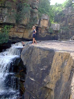
After about 50kms, we arrived in Daboula, a large town to buy vegetables and bread. It was Christmas eve and we had planned on staying at a large waterfall (Tinkisso Falls on the Tinkisso River, a tributary of the Niger), a few kms outside of Daboula. We arrived in the early afternoon with plans to stay 2 nights and celebrate Christmas here. A dam and powerplant had been constructed in 2005 by China on top of the falls. Initially there was a concrete dam about 150m long and then a winch system to control 2 gates, one open all the time that led to large penstock down to the power plant and another that was closed to provide for overflow. After the gates area was a 100m long spillway and a small reservoir backed up by the dam. Most bathed in the lake. This area is the Fouta Djalon, a majestic mountain plateau.
Tinkisso Falls are fantastic, about 80m high with at least 3 big cascades and several smaller, braided falls. A broad concrete sidewalk/road led down to the power plant and the base of the falls. Only 3 small-capacity wires emerged from the transformer yard. We walked around the power plant to bypass the water coming out of it and scrambled over black rocks and small streams to access the bottom of the falls. Views of the waterfall were best from a distance.
One soldier was in charge of protecting the dam. There were 3 buildings and we parked the truck in front of them and camped in the trees or flat areas around. Three young guys camped at the base of the falls. The forest was one species with huge leaves.
On Christmas morning, Steve made pancakes. Cooking over a wood fire presented difficulties – if the fire was too hot, the hot erupted in flames and a few of the pancakes were more charcoal than not. But they were a welcome change from porridge, Wheatabix and bread.
We had all drawn names for a secret Santa gift and these were distributed by Steve dressed up in the complete Santa outfit. A large mid-afternoon dinner had been planned and most everyone went to the bottom of the falls for a swim.
Two of the group left to travel south into Sierra Leone to climb Mt Bintunami, at 1945m, the highest peak in West Africa and the ultimate origin of the Niger River. The area is rich in bird and mammal life. It is apparently a serious 4-5 day approach and climb, but I think their main adventure might be getting there and then to Freetown.
Steve wanted to get to Conakry on Boxing Day and decided on a 4am start to get there at a reasonable time. The narrow, sometimes dirt, pot-holed roads and frequent villages with speed bumps did not allow fast travel. The terrain became much hillier. Everything had been densely forested for some time.
After Mamou, deforestation became more pronounced and the crops changed to banana, pineapple and many more vegetable plots with better looking soil. Palm trees became much more common. The yard structure was different too with fewer stick fences and thatched round huts. Each house had a “patio” in the front yard, often raised and surrounded by red volcanic rock. Immaculately clean, the base was small red basaltic pebbles. Rather than hanging clothes on a line, often they were laid flat on these patios. Electricity seemed rare outside towns.
I spend a lot of time looking out the window and am always kneeling on my seat when driving through towns. Everyone looks at the truck with wonder – Oasis has never traveled this route before and we are a real curiosity. Little kids go crazy yelling “white people” in their local language and waving. Most adults also wave and smile. We have so little close contact with these people and it is the only way to get some insight into their lives.
Major industries (all small operations) are furniture construction (big king-sized beds with carved head boards, chests, interior doors with raised panels), lumber mills, metal door construction with welding (doors for homes and large drive-way gates), concrete block production, wood gathering (meter long wood bundled with twine and stacked along the road) and animal fodder (straw and grass filled nylon bags).
At 4pm, after 12 hours of slow driving, we reached the first town with electricity. Still about 65kms from Conakary, Steve had phoned the Catholic Mission, where he had stayed before, and they had declined us staying there. We drove down a road and bush camped next to a small stream flowing over nice rock. We were soon surrounded by a bunch of kids who stayed until we went to bed. Communication was impossible as they spoke neither French nor English. But after eating all our left-over food, they demanded to take all our garbage for the glass and plastic.
At a police check-point, we were the only vehicle that had papers checked despite the barrier going up and down for every vehicle. Cars are completely packed – 3 in the front and at least 4 in the back seat of every vehicle. Many have a third seat. The roofs have some of the most amazingly tall loads, often with a couple of guys with a death-wish on top. Just after we passed an impressive overpass construction (probably Chinese) and eventually smooth pavement and a 4-lane divided highway. This didn’t last long as construction continues with long stretches of dirt. Concrete square-bottomed open sewer lines on either side are also being laid.
Corrugated roof shacks have restaurants, food, electronic goods, fans, household appliances, tire shops, plastic wear, hair salons, Orange Money kiosks (the most common phone cards and recharging stations) and construction supplies (stacks of cement and rebar). Furniture (huge plush couches and arm chairs, rattan, beds) line the road. Ragged cloth umbrellas provide cover for clothes on hangers. Shoes on tarps cover the ground. Women with head top trays of water and food and guys selling sun glasses and phone cards roam the crowds. Red dust covers everything. Garbage is everywhere except gas stations which are always clean. The road medians are garbage tips. Everyone is trying to make a buck.
Large crews wearing blue coveralls pick up garbage and shovel out the open sewers producing long piles of muck.
The boxy vans providing most public transport could not be packed with more bodies. Cars are generally in poor condition. The closer we get to Conakry, the more congested the traffic and more chaotic the scene outside the truck.
Women’s dress covers then entire range – rare full veils and black abayas, occasional Muslim head scarves, older women with colorful loose, long dresses and head scarves and young women with tight-fitting tops/long dresses showing shoulders, cleavage and bums. All have fake-gold costume jewelry and some wear lip stick. There are mosques in every town but no visible signs of Christianity. Men wear T-shirts, golf shirts and long pants. Most young men and all kids wear football jerseys.
CONAKRY
Moving at a snail’s pace, Steve announces that we are still 18kms out from Conakry. He wishes he had never heard of the place. I think watching the street scene fascinating. The only things making much headway are motorcycles. We passed an English Academy with Hilary Clinton’s picture painted on the wall. People stop noticing us amid the chaos and few wave. A guy tried to take our picture and we waved him off – most of the locals object to us taking pictures. Many kiosks sell lottery tickets – Guinea Games – Become a millionaire (a million Guinea francs is about 100€. We passed semi-trailers full of bananas with large stacks of mostly rotting fruit on the ground behind them.
Then we hit a stretch with no cars and zoom along, only to hit the traffic again. So after 4 hours to go 35kms, we finally got to downtown Conakry and parked outside the Catholic Mission, where they had already refused to let us stay (because they were too busy). We saw no one enter and it looked incredibly peaceful amidst a scene of chaos outside. We had 5 hours to look after business (get money, buy batteries, eat, walk around). The touts were frequent and did not give up. I had one fellow follow me for 15 minutes offering to clean my toilets (he reassured me he had all the necessary equipment) and look after me. Despite saying I was a tourist, he wasn’t willing to take that for an answer. This reflects the dire employment prospects.
Some of us went to the only tourist site in Conakry, Iles de Los, some islands just off the port. We arranged a guide, who was essential to be able to find a ferry and get back. The main business was prostitutes and selling marijuana. The older Indian fellow on the trip has many proposals of women baring their breasts for enticement.
With nowhere obvious to stay, Steve had arranged to stay in a public parking/public toilet compound next to the highway. The toilets have plastic tea kettles which seem hard to understand except when you realize they are only to flush the squat toilets. We slept on the concrete and tried to deal with the clouds of mosquitos. The sewer next to the highway is full of garbage and standing water and several creeks (also full of garbage and foul water) course through the city. Three of us wandered across the highway to go to a store and wander through the neighbourhood – another experience of the extreme poverty. Three people had stayed in town in a hotel. The 4-lane highway completely reversed in the morning with all four lanes dedicated to heading west into the city. It was a complete adventure getting the parking area, especially as they had no real idea where we were.
We finally left at 7:30 trying to find the alternate road heading east out of the city. We got to experience Conakry at its worst as the road made multiple twists and turns. We passed a big truck graveyard – about 25 large trucks in various states of rust and dismantling along the side of the street competing with the immense piles of garbage as the road traveled next to a creek. In busy market areas, the truck gained lots of attention. I love making eye contact with individuals as we crawled by. Big smiles and dancing antics greeted me. Some women had spectacular hair and costume jewelry. The markets are major chaos – everyone selling something either from on top of their head, under umbrellas or spread all over the ground – food, shoes and clothes are the common items.
At one point we passed a huge demonstration. Steve warned us not to take any photos of the riot police standing in one place observing the rioters. Surprisingly when they saw the truck, they stopped throwing rocks and quieted down. I have no idea what the issue was. The previously installed sewer along the highway had been completely ripped. Chinese engineers were supervising the Guinea labourers.
After another 4 hours to go about 35kms, we turned south to head towards Sierra Leone. That 100kms took at least another 4 hours on the narrow, pot-holed road. The pavement disappeared often to rolling dirt.
So after about 9 hours driving and 2 hours dealing with immigration, it was another long day on the truck.
Guinea/Sierra Leone border (Pamelap)
To obtain the entrance stamp, they had to record by hand all of our yellow vaccination details and then it took an hour for them to stamp the passports. An officious man demanded to see details about the truck that had been given when the visas were obtained. Steve remains calm throughout these encounters, the only way to behave. We were able to change money, for an unbelievably favourable rate. Surprisingly, our best money exchanges have been at borders.
It was late in the day when the Sierra Leone flag was being lowered. A man hit a big pipe and we were all ordered to stand at attention. Somebody came down the steps of the truck and the guy lost it. When the truck finally tried to enter Sierra Leone, we were informed that right-hand drive vehicles were illegal in S.L. and we couldn’t enter (the law had been passed in January, 2015 as apparently right-hand drive vehicles were responsible for 70% of all accidents. Steve got on a motorcycle to head across the border, returned after 20 minutes and we crossed.
GUINEA Jan 5-8, 2017
Liberia/Guinea Border. After 1 ¼ hours to get the Liberian exit stamp, we crossed from Ganta, Liberia over the border formed by the Mami River. It was another hour to get the Guinea entrance stamp at Diehé.
We had originally obtained a double-entry visa for Guinea as we wanted to return after Liberia to travel through the far south to go to a chimpanzee reserve.
We immediately passed through several plantations of mature rubber trees and palm oil. Now back in Guinea, we meet Islam, French, stick fences, the Guinea Franc, and baguettes for bread. Cars have astonishing loads on their roofs and motorcycles again have all the chrome and gas tanks covered in bubble wrap and plastic. It was Friday and we passed through a town at 1:30pm with the entire population on mats on the sidewalks facing east for the Friday service. Next came Sequepah, an unusual town with smart, painted identical houses inside compounds (a company town?). Most villages have houses made of mud bricks – any available dirt mixed with water and set out to dry. Every water course has a group of women washing clothes using large brown, plastic washboards. Everyone but the motorcycle and car repair guys are impeccably clean. Clothes hanging to dry or laid out on the ground are visible every day.
LOLA. This large town has a large pale green tiled mosque with four large minarets. We stopped to buy vegetables and bread and soon had a large group of laughing kids at the bottom of the truck stairs. Julia has a Polaroid camera and thrilled a few adults with pictures. Several of our group posed with the excited kids. I am not entirely sure of our attraction but think it is because they rarely see white people.
BOSSOU
We drove on a rough dirt road for 2 hours south of Lola to Bossou, home to a small troupe of chimpanzees held sacred by the local Manon people. We camped at the research facility south of town, a partnership of Guinea and Japanese primatologists from the University of Kyoto, and only one of six long-term chimp research projects in Africa. Here for the last 40 years, there were 4 Japanese researchers, most here for 3-week stints.
There is a small family group of 8 chimpanzees here that live on Mt Gban, a small hill that rises behind Bossou. The facility, in the mid 1990s, planted a green corridor of large trees connecting the Bossou chimps to the Mt Nimbo Unesco Biosphere Reserve to the south and home to a much larger group of chimpanzees. Camera traps have detected only two female Bossou chimps that have travelled along the corridor to enlarge their gene pool. Males from Bossou never go to Mt Nimbo, as they would be killed by the other chimp groups there.
Only eight of us took the tour to see the chimps in two groups of four. I was in the second group, supposedly with the worst chance to see this intriguing primate who shares an amazing 98,5% of our DNA. It is probably the least expensive chimpanzee tour in Africa at $55.
We left with our African guide at 9am, walked through the town and climbed through the bush to where 2 researchers were observing a single 5-year old male. He was very cooperative and sat in one place for 30 minutes while we took photos and watched through binoculars. The guide trimmed all the branches for great views. We then climbed up through the bush following the alpha male who posed on the trail for a few minutes. The highlight occurred when we spent another 30 minutes watching 4 animals in some big trees – the alpha male, another male, a female in estrous (shown by a completely everted vulva extruded as a grapefruit-sized mass in front of her anus) and a young chimp intent on hitting us with branches and small logs. Where ever we moved he tried to get on top of us for the best advantage. It was great fun avoiding the rain of stuff he broke off to hurl. Even though we were the second group, we had a vastly superior experience. Our photographers had hundreds of good photos while the other group got only a few. The guide said we were very lucky.
_06.jpg)
After the great morning, we went into town to eat rice and chicken and left in the early afternoon for the rough drive back to Lola to stock up on more food. After our great roads thus far, it was another poor dirt road for the 4-hour drive SE to get to the Cote d’Ivoire border. Every few kilometres, we passed through typical African villages of round, thatch-roofed huts and mud-brick homes. These small accumulations of homes have minimal garbage and their front yards are quite clean. We were a real novelty for all the children who immediately laugh, smile, yell and run out to wave at us. I’m not sure if it is the unusual truck or simply seeing white people who get them so excited. All the flat-bottomed creek bottoms have been restructured into rice paddies and raised vegetable beds with the small creeks providing irrigation.
A large crown forest fire had left large blackened trees. This is what happens when the dense 4m grass and underbrush is not burned regularly and has been a rare site on the trip so far. The landscape is relatively deforested, but with some large trees poking up from the brush. We drove through a huge area of 4m tall grass that forms an impenetrable barrier to foot traffic and then entered a bamboo forest that formed a dark canopy over the road. The bamboo grows in 5-10m dense clumps. There was then an almost completely intact rainforest where the road improved (a National Park?) and good forest the rest of the drive to Cote d’Ivoire. Where the grass is burned, huge conical termite mounds stick up from the fresh growth.
