
Lebanon Jan 24 – Feb 1 2016
TRAVEL TIPS
Lebanon is an expensive place to travel. Despite low wages, it is also an expensive place to live. Gas is 1,980LL ($1.32) per liter – more expensive than in Canada – (diesel 61¢/l).
1. There are few hostels and the only reasonable one is Hostel Beirut in Beirut (30,000LL or $20/night including a mediocre breakfast). Breakfast is served at 9 so I almost always missed it as I left at 7 for the long day trips. One of the hostel crew makes dinner – always good especially done by the fellow from New York and relatively inexpensive at 10,000LL.
2. Lebanon is a small country and a reasonable way to see the whole country is to stay in Beirut and make day trips: Tripoli, the farthest point north is 85kms, and Tyre, the farthest point in the south is 110kms. Baalbek and Bcharre are farther.
3. Transportation by bus is cheap: buses are about the same as share taxis which are much less than taxis, which are quite expensive. The only way to see Baalbek is by taxi, so try to join a group to share costs.
4. Getting around Beirut cheaply is confusing. The two main hubs are Dawra for the north and Cola to the south. Both are roundabouts. Cola is spread over several blocks and takes persistence to find the right bus. City buses seem infrequent and there are no bus stops so the routes are opaque at best. Service vehicles and taxis have red license plates. Service is only 2000LL anywhere but routes are also opaque. Taxis are expensive.
5. Airport. Getting to and from the airport is expensive. Theoretically Bus A goes from Dawra but stops about a kilometre from the airport. The hostel can arrange a taxi there for 17,000LL.
From the airport, a taxi at arrivals is 37,000. From departures, hard bargaining can get it down to 15,000 or rarely 10,000. Walk away several times. Try to find the bus stop.
Lebanon is a byword for conflict, but Lebanon, the original land of milk and honey, is a friendly, welcoming and culturally rich country, with one foot in the west and one in the Arab world. It’s home to the notorious Hezbollah (Party of God) headquartered in backwater Baalbek, also with dozens of poverty-stricken Palestinian and Syrian refugee camps.
Lebanon is chaotic and fascinating – scarred by decades of civil war, invasions, and terrorist attacks, yet blessed with serene mountain vistas, majestic ancient ruins and a people who are resilient, indomitable and renowned for their hospitality. Heed travel warnings but don’t miss the wonders of the country.
Connections. There aren’t many choices for getting into or out of Lebanon. The previous only land crossings into Syria have been closed since the civil war, and the Israel-Lebanon land border has been closed for years. Lebanon’s only airport is in Beirut. It’s small but efficient, handling an extensive network of international flights to and from Europe and the Arab world.
Travel Warnings. Most countries currently include Lebanon on their list of countries to which all but essential travel should be avoided. And if you come, avoid all refugee camps and all public demonstrations. But the people are generally warm, welcoming and eager to help travellers and as a result, I always felt safe and at home. When examined, travel warnings are necessarily very conservative. If something were to happen, realize that your travel insurance would be compromised. And your government would take no, or little responsibility for helping you.
Theft is a minor problem and random crime is far lower than in most Western countries. As in any large city, you only need to exercise normal precautions.
Official Name. Republic of Lebanon
Capital. Beirut
Population. 5.5 million (including 1.5 million Syrian refugees).
Language. Arabic (English and French widely spoken)
Money. Lebanese lira – LL (also known as the Lebanese pound). On January 26, 2016, 1 US$ = 1,512 LL. US$ are a part of daily transactions. Even if you pay in LL, change is often given in US$ at a rate of 1,500LL per US$. ATMs are widely available dispensing both lira and US$. Credit cards are only accepted in larger establishments.
Visas. All nationalities need a visa to enter Lebanon, though costs and visa requirements are constantly changing. For the most up-to-date information, visit the website of Lebanon’s General Security Office (www.general-security.gov.lb).
Citizens of Jordan and Gulf Cooperation Countries (Kuwait, Saudi Arabia, United Arab Emirates, Qatar, Bahrain and Oman) are entitled to a three-month visa at the airport free of charge.
Citizens of most other countries are entitled to a free one-month visa at the airport. For other nationalities, visas must be obtained in advance at any Lebanese embassy or consulate: you’ll need two passport photos, and possibly a letter from your employers stating that you’ll be returning to your job. Visas are usually issued the next day, but may take longer.
Israeli Passport Stamps. Lebanon denies entry to travellers with evidence of a visit to Israel in their passport. If asked at a border crossing or at the airport if you’ve ever been to Israel, bear in mind that saying ‘yes’ (if you have) will mean you won’t be allowed into the country.
Extensions. To extend your one-month visa to a three-month visa, go to the General Security Office (Rue de Damas, Beirut; 8am-1pm Mon-Thu, to 10am Fri, to noon Sat) in Beirut, a few days before your first month ends. Take a passport photo, your passport, and photocopies of your passport ID page and the page where your entry visa was stamped.
Resources. Lebanon Ministry of Tourism: www.lebanon-tourism.gov.lb. Lebanon Tourism: www.lebanontourism.com
BEIRUT (pop 1.3 million)
This is a city of contradictions: the city centre is filled with shopping, restaurants and nightclubs, but the outskirts of town comprise some of the most deprived Palestinian and Syrian refugee camps of all, and its crowded slums provide a breeding ground for Hezbollah fighters. Find the real East-meets-West. Crowded and ancient, beautiful and blighted, hot and heady, home to Prada and Palestinians, it is many things at once, but all compelling.
History. Though there is evidence of a city on the site dating back at least to ancient Egyptian times, it wasn’t until the Roman era that the city really came into its own, both as a commercial port and military base and, by the 3rd century AD, as the location of a world-renowned school of law, one to the first three in the world. The city’s fame continued until AD 551, when a devastating earthquake and resultant tsunami brought massive death, destruction and decline. The law school was moved to Sidon, and Beirut didn’t regain its importance as a trading centre and gateway to the Middle East until the 16th century under local emir Fakhreddine.
In the 19th century Beirut enjoyed a commercial boom, but meddling French arrived at the city’s port. The early 20th century saw WWI blockade, famine, revolt and plague, which killed a quarter of the population. Following WWII, it slowly became a major business, banking and publishing centre, and remained so until the bloody, brutal civil war that ravaged the city’s streets.
Following the end of the war in 1990, rehabilitation of the city’s infrastructure became the major focus of both the local and national governments, to restore its Paris of the East reputation. Beirut’s battle scars, however, remain visible throughout the city.
Arab Spring. Although the wave of revolts across the Middle East that began in 2011, has not directly involved Lebanon (aside from Syrian refugees seeking refuge in the country), its effects have been felt in the tourism sector. Tourism figures have dropped dramatically and the economy has suffered. Ironically, despite its reputation for instability, it has remained relatively calm throughout the Arab Spring and it has been the most stable country in the region.
Syrian Refugees in Lebanon. As a result of the civil war that started in 2011, there were 1, 070,000 registered (and another 500,000 unregistered) Syrian refugees in Lebanon as of January, 2016 (one-quarter of the Lebanese population). Camps and cities have become overpopulated causing rising tensions between Lebanese citizens and the refugees. The Lebanese government has never signed the 1951 Refugee Convention which secures refugees who belongs “to the frontiers of territories where his life or freedom would be threatened.” Therefore there exists no international laws which Lebanon must follow in dealing with the refugees – this has included the government of Lebanon not building any refugee camps. The refugees who are capable of working must compete with the poor of Lebanon for the country’s lowest paying jobs to get work and make money, which has resulted in damage to Lebanon’s economic infrastructure. The children of Syrian refugees must attend schools, which are already crowded with Lebanese children. As the numbers of Syrians in Lebanon have grown, so have tensions. The influx of Syrians into Lebanon has resulted in economic, political, social and religious tensions in Lebanon. Curfews have been put into place in some cities and villages to ensure public safety following attacks on police and members of the military by religious extremist groups. There have been numerous attacks on Syrian refugees by Lebanese citizens and the military including reports of beatings and shootings at checkpoints.
Beirut doesn’t have many tourist sites. There is an active café, restaurant, bar, and shopping scene in Hamra, Verdun, the Central District with Nejmah Square and the modern Beirut Souq, Gemmayzeh, and Achrafiye (the best of all areas).
Navigating Beirut can be frustrating as the blue signs on street corners don’t usually give the name and street number, numbered buildings are rare and many streets don’t have names. The biggest annoyance is the traffic. Rules are non-existent and pedestrians are not treated with much respect.
DOWNTOWN (CENTRAL) DISTRICT
Filled with gorgeous Ottoman-era architecture, in the 1980s, it had become the horrific, decimated center of the protracted civil war. In the 1990s, it was ambitiously rebuilt.
Mohammed al-Amin Mosque. With four 65m high minarets, it is an unmistakable landmark. Non-Muslims are welcome to see the impressive prayer hall with a great dome and huge cut-glass chandelier.

St George’s Orthodox Cathedral. Built in 1767, it is the oldest building in the city. During the civil war in 1975, it was struck by a bomb that unearthed the ruins of a Byzantine church, now a museum with original mosaic floors and tombs.
St George Maronite Cathedral. This 19th-century cathedral has a gorgeous marble interior and wood repository.
Al-Omari Mosque. Built in the 12th century as the Church of John the Baptist of the Knights Hospitalier, it was converted into a mosque in 1291. It has a wonderful barrel-vaulted stone ceiling. I watched an entire prayer session.
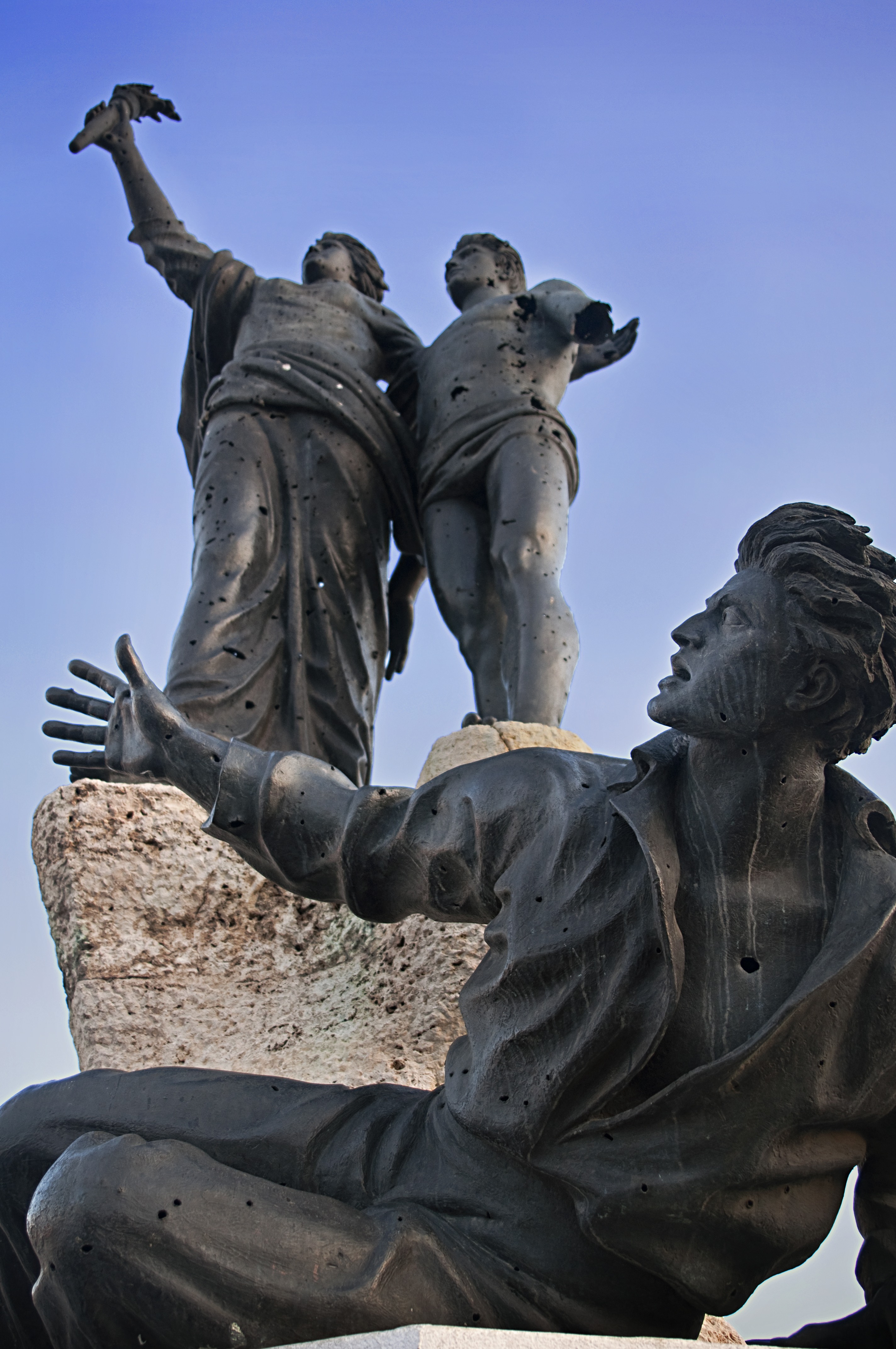
Martyrs’ Monument is a monument by Italian sculptor Marino Mazzacurati on Martyrs’ Square in the heart of downtown Beirut. It was inaugurated in 1960 to honour martyrs executed on Martyrs’ Square in 1916, at the orders of Ottoman military ruler Jamal Pasha.
Souq El Tayeb, ‘the good market’, is an open-air farmers market in downtown Beirut specializing in Lebanon’s organic produce. Since 2004 every Saturday on Trablos Street, farmers from all over the country gather their fresh produce, juices, jams, and labneh yogurt.
Beirut City Centre Mall. Located in the Hazmieh district next to the Damascus Highway, has 179 stores and 2200 parking bays.
Planet Discovery. The Souks shopping arcade is an activity centre and interactive science museum for young children with a separate art workshop where kids can mould clay or paint ceramics.
EAST BERUIT
Souq El Ahad. Under a highway bridge close to Corniche al-Nahr, the Sunday Market has had all things second-had for over 20 years. Every Saturday and Sunday spread across an indoor and an outdoor section, shop for an eclectic mix of trinkets, jewelry, antiques, clothes and electronics. Get up early as the stalls are set up at 7 am and packed away by 1 pm.
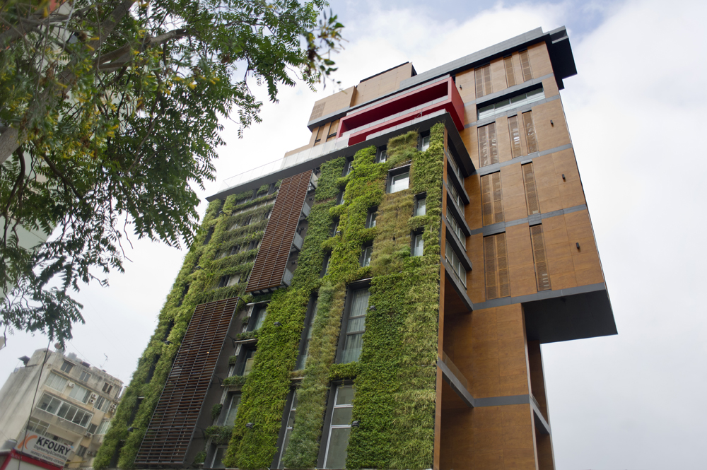
East Village Building. This combination apartment/art gallery has a vertical garden.
HAMRA
The university district has a plethora of hotels, cafes, bars and restaurants.
American University of Beirut. One of the Middle East’s most prestigious universities, it spreads over 28 tree-filled hectares. Founded in 1866, its 150th anniversary, along with the inauguration of its first Lebanese chancellor (all previous ones were American), was being celebrated the day we were there. The museum has a good display of artifacts.
National Museum of Beirut. This must-see museum situated on the former Green Line has an impressive, collection of archaeological artifacts, and offers a great overview of Lebanon’s history and the civilizations that made their home here.
Highlights include some beautifully observed Phoenician marble statues of baby boys (from Echmoun, 5th century BC), lovely 3rd- and 4th-century AD mosaics, Byzantine gold jewellery (found in a jar under the floor of a villa in Beirut) and the famous, much-photographed Phoenician gilded bronze figurines from Byblos.
I thought, as museums go, it was excellent. The exhibits were first-class with good, brief explanations in English.
It was then a straight walk down to the water, through Nejmah Place in Central (downtown) Beirut. Security is intense with armed soldiers at every entrance and bag searches. For some reason, 90% of the stores are vacant and have moved to the ultramodern Beirut Souqs.
Beirut Exhibition Centre – Photo Med Beruit. This was a photographic festival showcasing Mediterranean photographers in five venues around Beirut. It was a lot of interesting pictures.
I walked back to the hostel on the waterfront – without seeing the water. East of Central Beirut is a naval base, industry and port.
CORNICHE.
This is Beirut’s favourite promenade spot, especially in the early evening around sunset. Pigeon Rocks, at the southern end, are famous natural offshore arches.
ACHAFIYE. Historically one of the preserves of Beirut’s Christian population, it has galleries, antique shops, churches and a great nightclubbing street, Rue Monot.
ABC Mall Achrafiyeh
GEMMAYZEH. Thought by LP to be Beirut’s best district with hole-in-the-wall bars and live music.
The flight into Beirut airport must be the most scenic in the world. I sat on the left-hand side and the plane flew a few hundred meters from the shore giving great views of all of Beirut framed above the water.
I rarely get a taxi from airports, but here there was no close bus service. As usual, I went up to departures where the taxis were much cheaper. Starting at 37,000 LL (25$), I finally negotiated the price down to 22,500. It was raining hard and the taxi took me to the door of my hostel.
I stayed at Hostel Beirut, a great choice for 30,000 LL per night including breakfast. There was a large group of travellers to socialize and travel around with. Every night a cook prepared a large, delicious communal meal. Wifi was only ok. But I found the women staff somewhat less than helpful and one was lazy and rude.
On my first day, I went on a long walk-about with a Spanish woman. We walked from the hostel in Getawi to the water in the far west of the city visiting several mosques, all of the above churches, the American University of Beirut and walking back on the Corniche.
She wanted to go to Hamra to see this district. With little more than shopping and restaurants, I wish we would have continued on the corniche to our district. Initially warm, by the afternoon it had turned quite cold and I needed my puff jacket.
Religious Temples Beirut
Emir Munzer Mosque
First Armenian Evangelical Church
St. Claire de Notre Dame d’Unite Monastery
St. Gregory Armenian Catholic Cathedral
St. Louis Capuchin Church
Castles, Palaces & Forts Beirut
Baabda Palace. The official residence of the President of Lebanon. The palace was built in 1956 on a hill in the mountain town of Baabda overlooking Beirut.
Bustros Palace
Grand Serail
Robert Mouawad Private Museum
Sursock Museum
BEKAA VALLEY.
This fertile, pastoral valley is famous for its archaeological sites and infamous for being the homeland of Hezbollah. It’s actually a high plateau at 900m elevation between the Lebanon and Anti-Lebanon Mountains on the east side of the country. The valley is a northern extension of Jordan’s and the great East Africa Rift Valley geologically. The people are a mixture of Christians and Shiites.
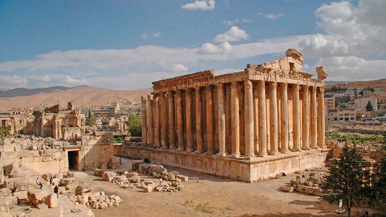
BAALBEK (pop 32,000)
Known as Helipolis or ‘Sun City’ of the ancient world, its ruins are the most impressive ancient site in Lebanon. The temples are extravagant and built to a scale that outshone anything in Rome.
Pottery shards from the 3rd and 4th millennia are the earliest evidence of human habitation. Reference to Egypt dating from 1900-1650 BC, the 12th century BC Iron Age, and the Phoenician City States from the 7th century BC have all been discovered. Baalbek became a Roman colony in 15 BC.
In 2006, Baalbek was attacked by the Israeli Air Force, several buildings were bombed, and a ground battle was undertaken where 16 Israelis and 2 Hezbollah died.
Roman Quarry. A kilometre away from the ruins is the quarry where most of the rock came from. Lying on its side still in the quarry is Hajjar al Hebla (“stone of the pregnant”), a 21×4.5×4.2m block that weighs 992 tons. However, it is not the biggest. The Western Megalith (trilithon), the base of the podium of the Temple of Jupiter is 20×4.8×4.6m and 1110 tons; but the biggest is 19.6×6.1×5.6m, 1673 tons and recently discovered. They were moved on rollers on a 15.2° incline using 16 groups of 32 men each (512 total) using clamps, ropes, capstans and 4 pulleys per group.
Roman Ruins. The ruins are stupendous.

The Temple of Jupiter, completed around AD 60, was built on a massive substructure about 48x88m in dimension on a 12m high podium and incorporated some of the largest building blocks ever used. It is the largest temple ever constructed in the Roman Empire. Today the remaining six standing columns are what is left of 19 columns on each side and 10 on each end. They are 20m high, 2m in diameter and 62 tons each in weight. All these massive blocks were moved using Lewis holes: 20-30cm deep and 4cm wide holes wider at the bottoms than the top into which Lewis pins, a hinged, metallic, trapezoidal structure was inserted. Each pin could lift 5 tons. The temple was never completed.
In the 2nd and 3rd centuries, a massive courtyard was constructed in front of the Temple of Jupiter, and in front of that a hexagonal courtyard on a 7m podium. The cult of Jupiter Heliopolitanus made sacrifices on 2 alters. In 312, Emperor Constantine converted to Christianity and in the 5th century, the alters were destroyed and replaced by a Byzantine church (Christian).
Bacchus Temple. Although there are no inscriptions to indicate the identity of the worshipped deity or date of completion, unlike the Temple of Jupiter, it was finished, likely in the 2nd century. It has 8 columns on one end and 16 on each side supporting an 18m high ceiling and has a lovely Corinthian decoration with acanthus leaf capitals and cornices. It is almost completely preserved having survived several earthquakes, several religious changes from paganism to Christianity and Islam and conversion to a dungeon in the medieval period.
Islam arrived and transformed the temples/church into a stronghold against the Crusaders from 1182-1230. The Bacchus Temple was incorporated into the citadel with the construction of a large hall, gate and mosque.
In 1260, the Mongols invaded and transformed the Bacchus Temple into a palace building a wall, towers and a moat on the north (all removed later).
Temples of Venus and Muses. These smaller temples were constructed in the 2nd and 3rd centuries and were left out of the main citadel during subsequent reconstructions. They are on your left right at the entrance to the complex.
Along with three others from the hostel, we rented a taxi, a much more convenient and faster route than the bus. Because of security reasons, it is not possible to get through the checkpoints on a bus anyway, and a taxi is the only way to go. This driver had been used several times before by people in the hostel, was very personal and a native of the valley. He was a nurse in a hospital in Beirut doing night shifts and drove around tourists during the day, functioning on 4 hours of sleep per day.
One passes through several checkpoints to get to Baalbek. The first two were the Lebanese government and the next three were Hezbollah. It had snowed on each of the previous 2 days and was snowing lightly on our day. The second was just before the high pass going over the Lebanon Mountains and we had to put on chains to continue. For 25,000 LL per chain (plus a 2000 LL tip), we felt this was simply a money grab between the police and the chain installers. The pass was covered with a few inches of slushy snow and chains were not necessary. After descending from the pass into Baalbek, the road was clear and we took off the chains. After 2½ hrs driving, we visited the temple (10,000LL) for about 2 hours, including a very good museum in a large barrel-vaulted hall under the whole complex. There were no other tourists and it was a surreal experience with the snow and the 11:50 call to prayer echoing across the valley simultaneously from the several mosques.
Shrine of Sayeeda Khawla. The 4-year-old daughter of Imam Hussein, one of the founders of Shiite Islam, she was abducted by Sunnis, paraded around southern Iraq, Syria and Lebanon and killed in Baalbek. Her tomb was in the original mosque that was replaced in 2002 by this modern mosque, one of the most spectacular mosques I have ever seen. Two tall gold-plated minarets flank a solid gold-covered dome (all fish scale plates). The outside is beautifully tiled in flowers and Arabic script (so each tile was individually produced, although repeated many times in the multiple panels).
.jpg)

The inside was unbelievable: Arabic script tiled columns and walls and then, on the upper walls and ceiling, amazing geometric patterns in mirrored glass, giving a dazzling, bright appearance. Inside was a massive ancient cedar tree enclosed in a small courtyard and Sayeeda Khawla’s tomb behind a decorative metal grill.

The shrine was financed by Iran. ISIS had made two attempts to destroy it five and 12 months previously.
Anjar (Haoush Mousa) is a town in the Bekaa Valley. The population is 2,400, consisting almost entirely of Armenians. After being abandoned in later years, Anjar was resettled in 1939 with several thousand Armenian refugees from the Musa Dagh area.
A UNESCO WHS formerly known as Gerrha, a stronghold built by the Umayyad Caliph in the 8th century, the site was later abandoned, leaving a number of well-preserved ruins surrounded by large, fortified stone walls over two meters thick and seven meters high, 370 m by 310 m. Two large avenues decorated with colonnades and flanked by about 600 shops divide the city into four quadrants. The main buildings are: Grand Palace, 59 m by 70 m, Small Palace, 46 m by 47 m, which stands out for its numerous ornamental fragments and its richly decorated central entrance, Mosque, 45 m by 32 m, is located between the two palaces and thermal baths. The fragments of friezes with plant, figurative and geometric motifs once richly decorated the buildings.
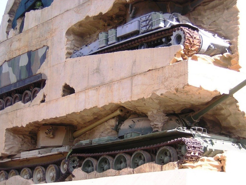
Hope for Peace Monument is a monument near the Ministry of National Defence. in Yarze passed on the drive to Baalbak. Built in 1995, it was made to celebrate the end of the Lebanese Civil War in 1990.
The monument is unusual in that it contains 78 military vehicles, from a range of era and nations. positioned in a bombed-out building constructed from 5,000 tons of concrete and stands 30 metres high. The tall memorial’s range of decommissioned military vehicles comprises armoured personnel carriers (APCs), tanks, gun-trucks and self-propelled gun (SPG) vehicles, including Charioteer tank destroyers, Sherman Firefly, M-50 and M-51 Super Sherman, T-55 and M47 Patton tanks, as well as Saladin armoured cars, a BTR-152 wheeled APC, a Panhard armoured car, an AMX-13 tank and a Ferret armoured car.

Ensemble du site naturel des sources et de la Vallée de l’Oronte avec les monuments qui s’y trouvent. A tentative UNESCO WHS, this landscape with stony fertile ground is desert and was abandoned after the war. The Orontes Valley is, in contrast, very green due to several springs that have carved a steep and winding passage in the rock. Monuments: Convent of Mar Maroun, Pyramid of Hermel, Trenches of the Zenobia aqueduct (linking Laboué to Palmyra), the Byzantine basilicas with mosaic floors of Ras Baalbeck and Nabha, the stelae and mosaics of Brissa.
Tfail is a village in eastern Baalbek District, at 1660m, one of the highest villages in Lebanon. It has a population of about 3,000 Sunni residents and is the most remote village in Lebanon, lying at the tip of a finger of territory that juts into Syria called the panhandle. On 1 May 2014, Tfail was the target of Syrian barrel bomb attacks.
Kefraya is a village in the Western Beqaa District 7 kilometres northwest of Joub Jannine. It is known for its vineyards and Château Kefraya wines in the foothills of Mount Barouk. Wine is exported all over the world.
We stopped at a restaurant that served a Baalbek specialty: a baked open-faced dumpling containing spiced beef. You could individually flavour it with lemon, salt, pepper, hot paprika and pepper-infused oil (I applied them all). They were delicious and accompanied by tabouleh and soured milk (lebin). But unexpectedly, the bill came to almost 20,000LL each, expensive for Lebanon.
There was a well-established 60-year-old Palestinian refugee camp in Baalbek. We also passed a plastic-tent Syrian camp just outside.
We understood the day would cost 25,000 LL per person (that is what everybody in the previous 2 days had paid, even when there were only two in the car) and we had to purchase one chain for 25,000 before the pass. No money changed hands until we were let off, double parked on Armenia Street, a busy, narrow street below the hostel with irritated honking drivers. We were told the price was 37,000LL, no one had changed and it all got weird. He lied to us about the others having to pay gas and we thought because there was four of us, the price should have been less. In the end, the day cost 63,250 LL including the lunch, much more than we had expected.
The fellow’s name was Mohammed and I would have recommended him by providing his phone number here, but have decided to only leave a warning about his behaviour.
He offered to take me to Damascus (he said it is possible, apparently quite safe, takes 2½ hours and goes over a much lower pass with no snow problems) but would not provide a price and instead did another weird thing by asking me what I was willing to pay. When I suggested a purposely low price for bargaining, he said that I was demeaning his services. As I wrote this in the hostel that evening, 4 people appeared in the hostel, one from Syria. They informed me that it was not a visa on arrival, the visa needed to be applied for, and required a good reason (like being a journalist or working for an NGO). One more strike against Mohammed.
Beit Mery. Set in pine forests some 800m above and 17km east of Beirut, Beit Mery – its name means ‘House of the Master’ in Aramaic – is a lazy weekend getaway for Beirutis seeking respite from city pollution, and offers sweeping panoramic views over the capital. The town dates back to Phoenician times and is home to Roman and Byzantine ruins, including some fine floor mosaics in a nearby 5th-century Byzantine church. Also worth a visit is the 18th-century Maronite monastery of Deir al-Qalaa, built over the remains of a Roman temple.
We drove through this area on our way back from Baalbek. The views down to the city and the water were splendid. Full of old large houses, it was nice simply to look around through the car windows.
NORTH OF BEIRUT
JEITA GROTTO
One of Lebanon’s greatest natural wonders and biggest tourist attractions, this stunning cave system extends 6kms back into the mountains. With two levels, the lower one, normally seen by boat, is closed on average about 50 days per winter as it floods due to the rising levels of the Nahr-el-Kalb (Dog River) for which they form the source. The upper cavern stays open all year. Accessed on a 700m walkway, it is a terrific cave with one of the most diverse and dense formations anywhere: narrow columns, huge draperies, a massive column of mushrooms, tufa in a flowing stream and huge amounts of fine soda straws on the roof. The walkway ends in a massive cavern 108m high X 57m in diameter with the stream far below. There was no one else there on the day I visited.
The grotto is 18 km NE of Beirut and is reached by minibus or bus, then a share taxi for 5kms. There is no public transport for the last 2kms and I hitchhiked getting a good ride from a Lebanese-Canadian couple from Montreal here on holiday.
JOUNIEH
Téléphérique is a gondola lift system in Jounieh 16 km north of Beirut opened in 1965.
In only nine minutes, the 1.5 km (1 mi) long Téléphérique line transports passengers from the bay of Jounieh, above the maritime highway and the pine-forested steep mountain, to 650 meters at the Our Lady of Lebanon shrine in Harissa. The trips offers panoramic views over the Bay of Jounieh. US $7.33.
Lebanese Heritage Museum.
BYBLOS (or Jbail, pop 22,000)
This fishing port has a medieval past.
History. The biblical Gebal was inhabited 7000 years ago and by the 3rd millennium BC, it was the busiest trading port on the eastern Mediterranean. Also an important religious center, it had links to Egypt and developed its distinct art and architecture. The modern alphabet was developed here by the Phoenicians to record its trade transactions. It was named Byblos by the Greeks as papyrus was shipped to Greece via Byblos from Egypt.
The Romans (Pompey) constructed temples, baths, colonnaded streets and public buildings. Conquered in the 7th century by Muslims, the Crusaders took it in 1104 and built a castle and moat. Subsequent centuries under Ottoman and Mamluk rule saw its trading port decline (replaced by Beirut) and it has been a sleepy fishing port since.
I took a service taxi (2000LL) to the Dawra bus stand, 7kms NE, and then a bus (2000LL) 37 km north to Byblos. Following next to the water, we never left the city. Get off the bus before the terminal (hopefully someone on the bus speaks English and knows where, and there are no signs, so here are detailed instructions): go up the hill to a wonderful ancient mosque (great stone minaret and unusual onion dome), turn right and cross to the west side of the highway over a bridge, continue straight to a shopping district, turn left and walk through the Old Souq passing by St. John the Baptist Church, and eventually turn right to get to the ruins (you can see the citadel from a distance).
RUINS. All but the castle are true ruins with only remnant walls. A fire in ~2300 BC destroyed all the structures.
Nympheum. A fountain dedicated to nymphs (feminine deities of creeks, forests and mountains).
Crusader Citadel. Built-in 1104, it has a 10m ditch, 5 towers and a 22m high central keep with 4m thick walls, the residence of the lord and last refuge in case of attack. It was renovated several times by the Mamluks and Ottomans. The city ramparts date from the 3rd millennium, the result of successive additions resulting in 40m thick portions.
Persian Fortress. A 6th-4th century fortress with an interesting lion’s head in one of the 7m walls.
Temple of Reshef (L-shaped Temple). Dating from 2700 BC. Reshef was the god of war (and also nature and fertility).
Obelisk Temple. Dating from the early 2nd century BC, this intriguing temple contained bronze votive offerings in the shape of human figures, now famously displayed at Beirut’s National Museum.
King’s Well. A 22m-deep well/spring that supplied the city with water until the end of the Hellenistic era (the king’s servants met the goddess Isis at the spring and took her to the palace where she found the body or her husband Osiris embedded in one of the pillars). The wells are one of the earliest remains on the site.
Early Settlements. The remnants of Neolithic (5th century BC) and Chalcolithic (4th century BC) enclosures, houses and huts. Throughout this area, large burial jars were found containing preserved bodies curled up in the fetal position.
Temple of Baalat Gebal (the patron goddess of the city, the “Lady Byblos” worshipped by the Pharaoh Khasikhemoui who reigned around 2700BC). Byblos’ old temple dates back to the 4th century BC. This was the largest and most important temple constructed at Byblos. The 1st millennial cultures were assimilated with the goddess Isis and later by Venus during the Roman period, and was rebuilt several times in the two millennia that it survived. Many temple findings, including alabaster vase fragments inscribed with the names of Old Kingdom pharaohs, are today also housed in the capital’s National Museum. The six standing columns approaching the temple are the vestiges of a Roman colonnaded street, built as the temple approaches around 300 AD.
Roman theatre. A reconstruction that’s one-third the size of the original, it is situated near the cliff edge with great views across the sea.
Royal Tombs. Nine tombs are cut in vertical shafts deep into the rock from 1990-1880BC to bury contemporaries of the 12th Egyptian dynasty. Some of the sarcophagi found here are now housed in the National Museum, including that of King Hiram, whose sarcophagus has one of the earliest Phoenician alphabet inscriptions in the world. His grave shaft also is inscribed, this time with the eerie phrase, ‘Warning here. Thy death is below’.
CHURCH of ST JOHN the BAPTIST (Eglise St Jean-Marc). In the center of the Crusader town, this Romanesque-style church, was begun in 1115, and was slowly added to in subsequent centuries. It’s thus an interesting mixture of Arab and Italian designs, with remains of Byzantine mosaics scattered about the area. It also features an unusual open-air baptistery, which sits against the north wall, its arches and four supporting pillars topped by a dome. Unfortunately, it was closed but there were wonderful metal sculptures outside depicting Jesus holding aloft giant nails.
I walked back to the highway and easily got a bus back to Dawra. There were 20 guys on the bus, none of whom spoke English – the driver was crazy and making bad jokes in Arabic. One Syrian felt sorry for me and walked me from Dawra to the steps below the hostel, and then refused to let me buy him dinner. He just turned around and walked the 30 minutes back to Dawra.
I went to a bar down on Armenia Street with three others from the hostel. It has been a while and I had forgotten why I don’t like bars. The company was good but the music was so loud that I got hoarse. I struggled to understand the Australian accent. And the one drink I had was overpriced. The many bars were packed. This is the vibrant nightlife that Beirut is so famous for.
Our Lady of Nourieh is a Marian shrine in Hamat near modern-day Chekka, It is believed that two sailors built the shrine in the 4th century – a cave in the cliff and dedicated it to the Virgin Mary, and called the shrine, Our Lady of Light. A Greek Orthodox monastery was built in the 17th century. The miraculous icon of the Theotokos has been venerated for centuries for having glowed with light to attract wayward ships. The shrine is a popular Christian pilgrimage site in Lebanon, and tourists and pilgrims alike enjoy the beautiful view of the bay from atop historic Cape Theoprosopon.
Hamatoura Monastery – Kousba is a village 18 km south of Tripoli, and 12 km east of Chekka. A main road from Chekka to Bsharri (called “Chekka Arz Highway”) passes through Kousba.
Late in the 13th century, the monastery was destroyed by the Mamelukes, but reestablished by St. Jacob admired for his spiritual briskness, vivacity, and popularity. Despite being imprisoned and tortured, he refused to give up his Christianity, he was beheaded and his body burned. He was later martyred.
Balamand Monastery. An Antiochian Eastern-Orthodox monastery founded in 1157 by Cistercian monks then in 1289 Greek Orthodox. It sits on a promontory 16kms SE of Tripoli.
TRIPOLI (Trablous pop 237,909)
Tripoli, 85km north of Beirut, is Lebanon’s second-largest city and the north’s main port and trading centre. Famous for its medieval Mamluk architecture, including a large souq area considered the best in Lebanon, it might seem a little run-down and provincial if you’ve come directly from Beirut. Tripoli’s main specialty is haliwat al-jibn, a teeth-jarringly sweet confection made from curd cheese and served with syrup.
You won’t have much luck finding a drink in town. For a beer on a hot day, head to Al-Mina, the port area 3km west of town.
History.
As early as the 8th century BC, Tripoli was already a thriving trading post, thanks to the constant comings and goings of traders from Tyre, Sidon and Arwad (the latter in present-day Syria). Each community settled in its area, a fact reflected in the city’s name, which derives from the Greek word tripolis, meaning ‘three cities’.
Conquered in turn by the Seleucids, Romans, Umayyads, Byzantines and Fatimids, Tripoli was invaded by the Crusaders in AD 1102, who held on to it for 180 years and built its imposing, and still-standing, hilltop fortress, the Citadel of Raymond de Saint-Gilles. In 1289 the Mamluk Sultan Qalaun took control of the city, and embarked upon an ambitious building program; many of the mosques, souqs, madrassas and khans that remain in the old city today date from either the Crusader period or subsequent Sultan Qalaun era. The Turkish Ottomans took over the city in 1516 and ruled, in relative peace, until 1920, when it became part of the French mandate of Greater Lebanon.
With a large influx of Palestinian refugees from 1948 onward, the city became the site of ferocious fighting during the civil war. Huge UN-administered refugee camps still hug Tripoli’s outskirts, including the Nahr el-Bared camp, now infamous for its protracted Palestinian/Lebanese army deadlock in 2007.
Citadel of Raymond de Saint-Gilles. Towering above Tripoli, this Crusader fortress was originally built from 1103 to 1104. It was burnt down in 1297 and partly rebuilt the following century by a Mamluk emir.
The most impressive part of the citadel is the imposing entrance, with its moat, causeway (that replaced the original drawbridge) and three gateways (one Ottoman, one Mamluk, one Crusader). There’s great signage and a spectacular viewpoint with vistas from the ocean, over the entire city and extending to the snow-capped peaks to the east.
OLD CITY
Dating from the Mamluk era (14th and 15th centuries), the compact Old City is a maze of narrow alleys, colourful souqs, hammams, khans, mosques and madrassas. It’s a lively and fascinating place where craftspeople, including tailors, jewellers, soap makers and coppersmiths, continue to work as they have done for centuries. The Souq al-Sayyaghin (the gold souq), Souq al-Attarin (for perfumes and spices), the medieval Souq al-Haraj and Souq an-Nahhassin (the brass souq) are all well worth a wander.
Great Mosque. The Great Mosque, built on the site of a 12th-century Crusader cathedral and incorporating some of its features, has a magnificent entrance, nice stone arches and an unusual minaret that was probably once the cathedral bell tower.
Madrassas. Opposite the mosque’s northern entrance is the Madrassa al-Nouriyat which has distinctive black-and-white stonework and a beautiful inlaid mihrab, and is still in use today. Attached to the east side of the Grand Mosque is the Madrassa al-Qartawiyya converted between 1316 and 1326 from the former St Mary’s church. Its elegant black-and-white facade and honeycomb-patterned half-dome above the portal are well worth a look.
Al-Muallaq Mosque. (Hanging Mosque) You have to glance up to see Al-Muallaq Mosque, a small and unusual 14th-century mosque on the 2nd floor of a building.
Khan as-Saboun. At the souq’s centre, the Khan as-Saboun was built in the 16th century and first used as an army barracks; since then, it has for generations functioned as a point of sale for Tripoli’s 400 varieties of famous soaps..
Khan al-Khayyatin. One of the most beautiful buildings in the old city is the Khan al-Khayyatin, formerly a Crusader hospital and today a beautifully restored 14th-century tailors’ souq lined with small workshops.
Taynal Mosque. Standing on its own to the south of the souqs on the outskirts of the Old City, but well worth the walk, is the restored Taynal Mosque. It dates from 1336 and represents probably the most outstanding example of Islamic religious architecture in Tripoli. It has three wonderful stone domes and great arches.
Al-Burtasiya Mosque. Close to the souq, the mosque has a particularly fine mihrab decorated with stone and glass mosaics overlaid with gold leaf.
At 7 am, I walked to the Dawra bus stand from the hostel (30 minutes on Armenia Street) and got the bus 2 hours north to Tripoli. I then saw everything above. Tripoli appeared to be more economically depressed than Beirut – more people shining shoes, selling ‘stuff’ on the sidewalks, and generally men standing around with nothing to do. There were many beggars, all women, many with children, and I can’t remember the last time I was “hit on” so many times. Oddly there were hundreds of old Mercedes sedans, many of them taxis, but many just driving around. At first, I thought there was a Mercedes rally.
After my second delicious falafel, I took the bus to Bcharre (5000LL, taxis were 75000LL).
NORTH of TRIPOLI
Horsh Ehden is a Nature Reserve located on the northwestern slopes of Mount Lebanon with a remnant forest of the cedar of Lebanon. Often misty with relatively high precipitation, the reserve’s valleys and gorges have cedars, juniper, fir, and wild apple trees. Animals include eastern imperial eagle, gray wolf, wildcat, golden jackal, red fox, wild orchids, salamanders, and mushrooms.
Batroun is a coastal city in northern Lebanon, one of the oldest cities in the world with Roman Catholic and Greek Orthodox churches. The town is also a major beach resort with a vibrant nightlife of pubs and nightclubs. Citrus groves surround Batroun, and the town has been famous for its fresh lemonade.
History. The Phoenicians founded Batroun, it was Byzantine, Roman and later Christianized. In 551, Batroun was destroyed by an earthquake, which also caused mudslides to form the large natural harbour. One of Batroun’s medieval archaeological sites is the Crusader citadel of Mousaylaha which is constructed on an isolated massive rock with steep sides protruding in the middle of a plain surrounded by mountains.
Monastery of St. Joseph, Tomb of St. Rafqa (1832 – 1914). She was a nun renowned for her suffering. The monastery is in Batroun.
BCHARRE & the QADISHA VALLEY
Ouadi Qadisha. This is the gorge of the Kadisha River, known as the Nahr Abu Ali when it reaches Tripoli. Kadisha means “Holy” in Aramaic, and the valley has sheltered Christian monastic communities for centuries. The valley is located at the foot of Mount al-Makmal in northern Lebanon. In 1998, UNESCO added the valley to the list of World Heritage Sites because of its importance as the site of some of the earliest Christian monastic settlements in the world, and its continued example of early Christian faith.
The trip up to the pretty town of Bcharré takes you through some of the most beautiful scenery in Lebanon. The road winds for over 60 km along mountainous slopes, continuously gaining in altitude to over 1800m.
Views down to Tripoli and the ocean are wonderful. Red-roofed villages perch atop hills or cling precariously to the mountainsides covered with some of the most extensive terraces in the world (more even than Peru or China) and these are all faced with lovely rock walls. Lebanon’s highest peak, Qornet as-Sawda (3090m), soars overhead. Bcharré is the only town of any size in the area.
The road climbs up the Qadisha Valley, a Unesco World Heritage site home to rock-cut monasteries, wildlife, hiking quiet valley trails or scaling bleak mountain landscapes. The trip offers spectacular views of the valley and river.
St Saba Church dominates Bcharré’s little town centre.
Gibran Museum. Lebanon’s most famous poet and artist Khalil Gibran (1883–1931), is buried in a 19th-century monastery built into the rocky slopes of a hill overlooking Bcharré. There are some Phoenician tombs behind the museum.
Qadisha Grotto. Extending 500m into the mountain, it has some great limestone formations and a spectacular setting.
Monastery of Saint Anthony of Qozhaya. The valley of Qozhaya, along with the valley of Qannoubine to which it is connected to the west, form what is called the valley of Qadisha.
Qozhaya is considered to be one of the oldest monasteries of the valley of Qadisha. Several hermitages are attached to it and in the 12th Century AD, it was the See of the Maronite Patriarch. In 1584, the first printing press of the Middle East was installed in this monastery. In the first part of the 19th century, it had more than 300 monks and with its large properties in the valley, is one of the richest monasteries of the Order. Qannoubine: Mar Licha Monastery. Another monastery in the valley is situated under overhanging cliffs.
The Cedars. Ten kilometres past Bcharre is one of Lebanon’s most attractive ski resorts. The Cedars is also its oldest and most European in feel.
The village takes its name from one of the country’s few remaining groves of cedar trees, which stands on the right-hand side of the road as you head up towards the ski lifts. A few of these slow-growing trees are thought to be approaching 1500 years old. You can usually walk through the forest on marked trails between May and October, except when the ground is soft and tree roots might be damaged.
The ski season takes place here from around December to April, depending on snow conditions, and there are currently six lifts in operation.
I caught the bus from Tripoli to Bcharre on a clear day so had wonderful views, especially of the mountains. This is one of the most epic road trips in the world. A taxi was 75LL for those with deep pockets. To get to the Cedars and back was 30LL by taxi only. I had no interest in skiing and wouldn’t be able to hike through the trees or even see them up close, so had already decided that I wouldn’t go past Bcharre. I arrived at 2:30 pm (that same bus returned to Tripoli at 3:30 pm and I was looking forward to having a coffee and visiting the imposing church), but the direct bus to Beirut drove by at 2:31 pm and I jumped aboard. This was just too convenient.
SOUTH OF BEIRUT
SIDON (Saida pop 170,516)
A small, workaday but attractive port town lying 40km south of Beirut amid thick citrus and banana groves, Sidon is most famous in modern times as the birthplace of assassinated former prime minister Rafiq Hariri.
History. it was a rich and flourishing Phoenician city, with tight trade links to ancient Egypt and a globally renowned glass-making industry.
Traces of Sidon’s rich history can still be found all over town, with many ancient remnants tucked away in its intriguing medieval souqs. Unlike pretty Byblos to the north, Sidon makes few concessions to tourists: here, the history is very much part of everyday life.
Except for the Sea Castle, all of Sidon’s sites are free to visit. The LP had no map, so finding all these places required lots of requests for directions.
Sea Castle. Erected in 1228 by the Crusaders, the Sea Castle sits on a small island formerly the site of a temple dedicated to Melkart, the Phoenician version of Hercules, and is connected to the mainland by a fortified stone causeway. Like many other coastal castles, it was largely destroyed by the Mamluks to prevent the Crusaders from returning to the region but was renovated by Fakhreddine in the 17th century. On calm days, you can see numerous broken rose granite columns lying on the sea floor beneath the castle; archaeologists think there’s plenty more of this sort of history to be discovered further off Sidon’s coast.
OLD CITY
Old Sidon, a fascinating labyrinth of vaulted souqs, tiny alleyways and medieval remnants, stretches out behind the buildings fronting the harbour. Officially, there are 60 listed historic sights here, many in ruins, although renovation work is ongoing. In the souqs, you’ll find craftspeople plying the same trades their ancestors did for centuries. I loved walking around here more than anywhere else in Lebanon. All lovely tan stone, it is a lived-in neighbourhood. Once past the usual shops at the entrances, you enter a labyrinth of atmospheric lanes.
Khan al-Franj. A highlight of the souq area is the Khan al-Franj (Inn of the Foreigners), the most beautiful and best preserved of all the limestone khans built by Fakhreddine (Fakhr ad-Din al-Maan II) in the 17th century. Wonderfully restored, it consists of vaulted arcades surrounding a large rectangular courtyard with a central fountain. Today it houses the Hariri Foundation, founded by assassinated former PM Rafiq Hariri, which works on various restoration projects throughout the city and beyond. It is easy to find, as it fronts the water just south of the Sea Castle.
Great (Omari) Mosque. Facing the northern tip of the harbour, the Great (Omari) Mosque is said to be one of the finest examples of Islamic religious architecture of the 13th century and was originally converted from a fortified Knights Hospitaller structure. Severely damaged by the Israeli bombings of 1982, it underwent a long restoration and now looks spectacular once again. I had a long conversation with a fellow here about Islamic belief, peace and how the world views Islam. The long wall at the entrance to the mosque had been plastered and 4 guys were almost finished removing the inch-thick cement. They then chipped the entire surface of the stone, cleaned all the joints and repointed them all. What had been done was gorgeous.
Bab as-Saray Mosque. Just behind the Khan al-Franj, the Bab as-Saray Mosque is the oldest in Sidon, dating from 1201, and filled with beautiful stonework. The high dome is a masterpiece of stonework.
Between Sidon and Tyre is one big banana plantation/orange grove.
Musée du Savon. Located in an old soap factory dating from the 17th century, this surprisingly interesting museum is Lebanon’s only museum of that most humble yet indispensable of products. Well laid out, with trilingual explanations on the art of ‘saponification’ (which we nonsaponifiers might call ‘soapmaking’). Despite looking for quite a while, I never did find this place.
Palace Debbané. Another gem, entered from the souq via a tall staircase marked with a sign. Built in 1721, this former Ottoman aristocrat’s building has intricate Mamluk decoration, including tile work, cedar wood ceilings, and various historical exhibits. I found this but it was closed for renovation till March 31 2016.
Temple of Echmoun. About 2km northeast of Sidon, this temple is Lebanon’s only Phoenician site boasting more than mere foundations. Today it contains the remains of temples and shops, as well as some interesting mosaics (although most are damaged). Begun in the 7th century BC, the temple complex was devoted to Echmoun, god of the city of Sidon, and other buildings were later added by the Persians, Romans and Byzantines. Today the highlight of the site is undoubtedly the throne of Astarte, flanked by two-winged sphinxes.
TYRE (Sour pop 142,755)
Notoriously famous for its local hero Hassan Nasrallah and best-known scenically for its extraordinary Roman ruins, it is a picturesque and intriguing destination,
Tyre is an oft-troubled town with an abundance of both UN soldiers (white UN vehicles are everywhere) and Unesco World Heritage sites. Every time the city attempts to get to its feet following a disaster, it seems to be struck down by a new catastrophe. Though it has generally proved safe to visit in recent times, be sure to heed local travel warnings, and it makes sense to avoid Palestinian refugee camps unless you’re with a trusted local.
History. Tyre’s origins date back to its foundation in approximately 2750 BC, after which it was ruled by the Egyptians and then the famous King Hiram (who sent cedar wood and skilled workers to Jerusalem so that the Hebrew King Solomon could build the Temple of Jerusalem), under whom it prospered. Later colonized variously by the Assyrians, Neo-Babylonians, Greeks, Seleucids, Romans, Byzantines, Arabs, Crusaders, Mamluks and Ottomans, Tyre began to languish from the 13th century onwards and, despite many attempts, never quite recovered its former glory.
OLD TYRE. The old part of Tyre lies on the peninsula jutting out into the sea. The modern town is on the left-hand side as you arrive from Beirut. Behind the port is the Christian quarter, with its tiny alleys and old houses with shaded courtyards.
In 1984 Tyre was declared a Unesco World Heritage site, and its archaeological remains are divided into three parts: Al-Mina (Areas 1 and 2) on the south side of the city, Al-Bass (Area 3) on the original mainland section, and medieval site in the centre of town.
I was let off on the corniche and had a beautiful walk to the peninsula, through the Christian quarter then along the water to the Crusader Cathedral. Then I saw the rest of the Al-Mina site and walked through the city to the Al-Bass site (I climbed the fence at the back of the site near the hippodrome to save myself a few kilometres of walking) and then caught a mini-bus back to Sidon.
Al-Mina Archaeological Site. The ruins, dating to the third millennium BC, cover a large area leading down to the ancient Egyptian submerged harbour. It features a mosaic street paved with impressive geometrical Roman and Byzantine mosaics, on each side of which are rows of large columns, made of green marble imported from Greece. There is an unusually large public Roman bathhouse from the 2nd or 3rd century AD and a 4th-century rectangular arena which would have held up to 2000 spectators, perhaps to watch some sort of ancient water sport.
A five-minute walk north of the main Al-Mina site brings you to the ruins of a 12th-century Crusader cathedral and a network of Roman and Byzantine roads. It is a jumble of rock walls and several nice marble columns.
Al-Bass Archaeological Site. This enormous site lies 2km from the Al-Mina site. Just past the entrance is a vast funerary complex, with hundreds of ornate stone and marble ancient sarcophagi lining the road, some intricately carved with the names of the occupants or reliefs drawn from the Iliad. A well-preserved Roman road stretches in a straight line for about 1.6km from an impressive 20m-high monumental archway that probably dates from the time of Emperor Hadrian (2nd century AD). Beyond the archway is the largest and best-preserved Roman hippodrome in the world (holding more than 20,000 spectators), built in the 2nd century AD for the ancient adrenalin-charged sport of chariot racing. At the far end of the road are the remains of Roman aqueducts, parts of which are still held up by arcades.
On the way to the Al-Bass site, you pass the Al-Bass Palestinian Refuge Camp. I peered in but foreigners can’t enter without a permit. The entrance was guarded by Lebanese soldiers. The Palestinians have now been here for over 60 years and the camps have structured homes but little infrastructure like sewage systems, reliable water supplies or “normal” electrical service. They have none of the privileges of Lebanese, like access to schools, medical care or jobs and exist outside of that society.
For a full day of travel, the taxi to COLA bus stand was 6000LL and the four minibuses to Tyre and back were 8000LL, quite a deal, probably less than the $1 per hour that always signifies the cheapest travel.
In Sidon, I had a wonderful felafel. The little shop was packed and it was a wonder to watch the old guy and his assembly line production. I chatted with his son who was standing at the back watching his Pa at work. I asked him how many felafels they had to sell to send him to University.
Lebanese women wear a whack of makeup: heavily pencilled eyebrows, a ton of mascara and thick full face “stuff”. Islamic women are very impersonal, a hijab does nothing for their appearance and I don’t find them in the least attractive. Surprisingly, I saw many older women smoking today, both cigarettes and shisha.
Scandelion Castle is a Crusader castle located in the city of Iskandarounah just south of Tyre, built in 1124 AD and became a strategic high ground, used to defend Tyre.
Cana. According to the Gospel of St John, Jesus Christ is said to have performed his first great miracle of changing water into wine at the wedding feast of Qanah. The location of the biblical Qanah is disputed but the Lebanese believe Qana, 10km southeast of Tyre, is the true site and that the Grotto of Cana is the cave where Jesus Christ is believed to have slept the night. A series of ancient sculptures depicting the life of Jesus are etched into the rock lining the path to the cave.
Tyre Coast Nature Reserve to the southeast of Tyre covers over 380 hectares public beaches, the old city and Souks, the ancient port, the agricultural and archaeological zone, and the Conservation zone that includes the Phoenician springs of Ras El Ain. Established in 1998, is an important wildlife sanctuary and includes a public beach with yellow sand. The reserve is bisected by the Rachidiye refugee camp.
It is an important nesting site for migratory birds and the endangered loggerhead and green sea turtle.
Tibneen, 28km southeast of Tyre, stand the ruins of a crusader castle built in 1105. The massive fortification wall is hard to miss, as is its commanding position on a hilltop in the centre of town. On a clear day, the views from the castle are spectacular – sweeping across the fertile landscape, the mountains and the coast – and are reason enough to visit.
I did not go here. Including it on a day trip from Beirut would have been impossible if you want to see both Tyre and Sidon.
CHOUF MOUNTAINS
These spectacular mountains, southeast of Beirut, are the southernmost part of the Mt Lebanon Range. In places they’re wild and beautiful; in others, they’re dotted with small villages and terraced for easy cultivation.
Beitteddine Palace (BEIT AD-DIN)
Located in otherwise unexceptional Beiteddine village, one of the highlights of the Chouf mountains is undoubtedly the early 19th-century Beiteddine Palace around 50km southeast of Beirut.
Sitting majestically on a hill, surrounded by terraced gardens and orchards, the palace was built over 30 years by Emir Bashir, Ottoman-appointed governor of the region, starting in 1788. Meaning ‘House of Faith’, the Beiteddine Palace was built over and around an older Druze hermitage. During the French mandate the palace was used for local administration, and after 1930 it was declared a historic monument. In 1943 Lebanon’s first president after independence declared it his summer residence. The palace was extensively damaged during the Israeli invasion; it’s estimated that up to 90% of the original contents were lost during this time. When the fighting ended in 1984, the palace was taken over by the Druze militia, and Walid Jumblatt, their leader, ordered its restoration and declared it a ‘Palace of the People’. In 1999 the Druze returned it to the government.
Although conceived by Italian architects, the palace incorporates many traditional forms of Arab architecture. The main gate opens onto a 60m-wide outer courtyard (Dar al-Baraniyyeh) that’s walled on three sides only; the fourth side has great views out over valleys and hills.
A double staircase on the outer courtyard’s western side leads into a smaller central courtyard (Dar al-Wousta) with a central fountain. Beyond this courtyard is the third – and last – inner courtyard (Dar al-Harim). This was the centre of the family quarters, which also included a beautiful hammam and huge kitchens. All the floors are wonderful marble geometrics and the ceilings are extravagant Italian wood.
Underneath the Dar al-Wousta and Dar al-Harim are the former stables, now home to an outstanding collection of 5th- and 6th-century Byzantine mosaics. Found at Jiyyeh in a church uncovered in an excavation, 30km south of Beirut, they were brought by Walid Jumblatt to Beiteddine in 1982. Whatever you do, don’t miss them: they’re truly stunning.

The palace hosts a wonderful annual music festival during July and August (www.beiteddine.org).
Moussa Castle is a castle built on a hill Deir el Qamar and Beit ed-Dine, the life work of a Lebanese visionary (1931-2018), requiring 60 years of dedicated hard-work to finish. His initial work was in restoring castles. He bought the land and started on his in 1962.
Deir al-Qamar (“Monastery of the Moon“) is a village 5kms outside of Beiteddine at 800 m. During the 16th to 18th centuries, it was the capital of the Emirate of Mount Lebanon. People from all religious backgrounds lived there and the town had a mosque, synagogue and Christian churches. In 1860, the town was set ablaze during the civil war between Druze and Christians. Today, 85% of Deir al-Qamar’s inhabitants are Maronites and 14% are Melkites.
The village is very picturesque with typical stone houses and red tile roofs. The Saydet El Talle is a 15th-century Maronite church. Mount of the Cross has the 2007 Lamb of God Shrine. Our Lady of Tamiche Monastery is nearby. Fakher El Dine Ii Le Grand Castle.
CHOUF CEDAR RESERVE
The largest of Lebanon’s three natural protectorates, the Chouf Cedar Reserve comprises an incredible 5% of Lebanon’s total land area and has over 250km of hiking trails. Within it are ancient rock-cut fortress remains and six of the country’s last remaining cedar forests, some with trees around 2000 years old. More than 200 species of birds and mammals (including wolves, gazelles and wild boar) inhabit or regularly pass through the area.
There are four main entrances (Ain Zhalta Bmohray, Barouk, Maasser and Niha). If you’re not coming here by your car, hitchhike or negotiate a taxi fare (around US$20) from Beiteddine, some 10km away.
I took a bus from Cola to the intersection of the Beiteddine Palace, walked and hitchhiked to the Palace, hitchhiked back to the intersection and with 3 rides got rides to the Barouk Cedar Reserve, high up in the mountains. There was a fair amount of snow on the ground and all the Lebanese families were making snowmen. I escaped the $5 entrance fee when the guard mistakenly thought I was part of a Lebanese family. We walked 2kms up the road through fairly small trees. It was another 2kms to the biggest 2000-year-old trees and we elected to turn around. Cedar honey in the ranger station sold for 30,000LL for a 250cc jar.
I then started hitchhiking again: first with two 17-year-olds who could only talk about smoking hashish. Then a family of three who could speak only Arabic picked me up and took me to who knows where. A young woman took pity on me and drove me to Kfarheem, still high in the mountains but on the other side from Beiteddine. She was Druze like most people who live in the Chouf Mountains and an MBA student who dreams of moving to Canada. She had arranged a position at a Canadian university, but her parents didn’t want her to go, so she didn’t – how different from Canadian kids – I wouldn’t dream of telling my kids to do anything. She phoned a bus driver, who luckily was arriving in Kfarheem in 20 minutes driving to Cola in Beirut. So I got to Beiteddine Palace and the Cedars and back to Beirut for 6000LL ($4) and met many great generous Lebanese on the way. I do believe I can be the luckiest person in the world.
I walked the hour from Cola to the hostel.
Theresa slept with me all night on my last night. She had crawled under the covers a few times before but never stayed long. She’s been sleeping on my bed during the day – I think she likes my down sleeping bag. I don’t like many cats, but this one is quite sweet. It is hard to understand what appealed to me about her. When I thought about it, every one of my six or so partners since getting divorced had a cat. I only liked the neighbour’s cat who had adopted Barb and I and Dana’s two hairless cats were kind of neat, but the rest….. Although I had not heard Theresa purr all week, when I woke up she purred a lot and was very attentive, nipping my hand gently. Of all the people who worked in Hostel Beirut, she was the only one I cared for – the rest were all “cool snobs”. Otherwise, it is a good hostel and I would highly recommend it. There was an amazing variety of travellers from all over the world and many worked with refugees.
On February 1st, I flew to Amman on Middle East Airlines for 130$, a good deal.
OTHER SIGHTS IN LEBANON
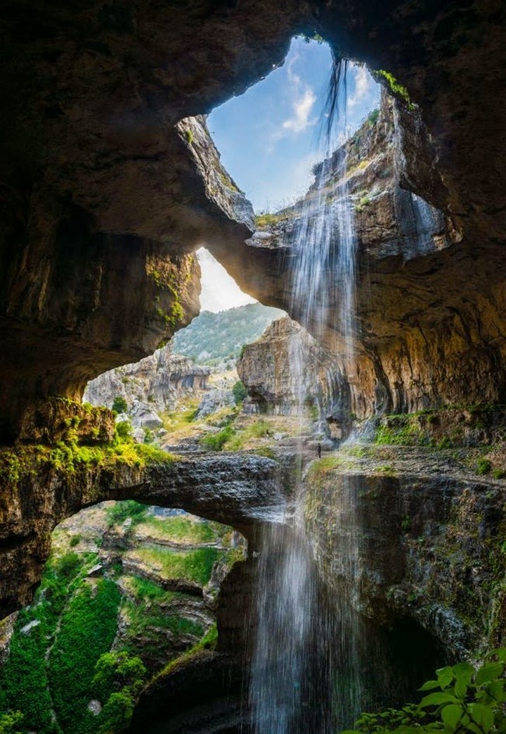
Baatara Gorge Sinkhole and Waterfall is a waterfall in the Tannourine, near Balaa. The waterfall drops 255 metres (837 ft) into the Baatara Pothole, a cave of Jurassic limestone located on the Lebanon Mountain Trail. The cave is also known as the Cave of the Three Bridges.
Travelling from Laklouk to Tannourine one passes the village of Balaa, and the Three Bridges Chasm is a five-minute journey into the valley below where one sees three natural bridges, rising one above the other and overhanging a chasm descending into Mount Lebanon. During the spring melt, a 90–100-metre (300–330 ft) cascade falls behind the three bridges and then down into the 240-metre (790 ft) chasm.
Discovered in 1952, the waterfall and sinkhole were fully mapped with a 1988 fluorescent dye test that showed the water emerged at the spring of Dalleh in Mgharet al-Ghaouaghir near Balaa.
Hasbeya is a town at the foot of Mount Hermon, the capital of the Wadi El Taym, a long fertile valley running parallel to the western foot of Mount Hermon. Hasbaya is mainly inhabited by the Druze. A good deal of its history transpired at the huge citadel that is today Hasbaya’s chief claim to fame.
Overlooking the modern village of Hasbaya, the Chehabi Citadel occupied a strategic location for the armies of the First Crusade, who are believed to have built the original fortifications in the eleventh century. The strategically sited outpost was also used by the Chehabi emirs, who ousted the Crusaders from the area in the 1170s and rebuilt much of the citadel complex for military and residential use. Chehabi descendants have continually occupied the site up until this day.
FAR SOUTH
Nabatieh is a city in southern Lebanon with about 37,000 people. A market is held every Monday.
The Nabatieh is known for its grottos – Ich Al-Khourab, “the crow’s nest,” and Maghar Mahalah, “the red spot.” Also of interest are some ancient rock tombs, Roman and Byzantine ruins, and two very old mosques.
Beaufort Castle. Although looking inaccessible, can be reached with little difficulty from the village of Arnoun, which lies 7 kilometres (4.3 mi) southeast of Nabatieh. The Crusaders repaired and fortified Beaufort Castle during the twelfth century and it became the most important fortress in Lebanon.
Nabatieh has two historic mosques. The inhabitants of Nabatieh are predominantly Shi’a Muslims, with a significant minority of Greek Catholics. Naqoura is a small city in the southwestern corner of Lebanon. Since 1978, the United Nations Interim Force in Lebanon (UNIFIL) has been headquartered in Naqoura.
Ghajar Alawite-Arab village on the Hasbani River on the border between Lebanon and the Israeli-occupied portion of the Golan Heights, internationally considered to be de jure part of Syria. In 2017 it had a population of 2,559.
History. In 1932, the predominantly Alawite residents were given the option of choosing their nationality and overwhelmingly chose to be a part of Syria, which has a sizable Alawite minority. Before the 1967 Arab-Israeli War, Ghajar was considered part of Syria and its residents were counted in the 1960 Syrian census. When Israel occupied the Golan Heights from Syria in 1967, Ghajar remained a no-man’s land and the villagers wanted to be part of the Israeli-occupied Golan Heights. In 1981, most Alawi villagers accepted Israeli citizenship but the unilateral annexation was not recognized by the international community. In 1978, Israel withdrew from Southern Lebanon and Ghajar expanded northward into Lebanese territory, subsuming the Wazzani settlement north of the border. In 2000 Israel withdrew their troops from Lebanon and in an attempt to demarcate permanent borders between Israel and Lebanon, the United Nations made the Blue Line – the northern half of the village came under Lebanese control and the southern part remained under Israeli control. This arrangement created much resentment among the residents, who see themselves as Syrian.
Residents on both sides of the village have Israeli citizenship; those in the northern half often hold passports from both Lebanon and Israel. They work and travel freely within Israel, but those living on the Lebanese side have difficulties receiving services from Israel. There is an Israel Defense Forces checkpoint at the entrance to the village, and a fence surrounding the entire village, but no fence or barrier dividing the two sides of the village.
The UN has physically marked the recognized border and Israeli soldiers remain on the Lebanese side of Ghajar. UNIFIL military observers patrol the area continuously. The Lebanese Armed Forces patrol the road outside the perimeter fence. As long as the Israel Defense Forces remain in northern Ghajar, Israel will not have completed its withdrawal from southern Lebanon under its obligations.
SUMMARY OF LEBANON
Lebanon in January 2016 was very safe. But it is relatively expensive. Because the country is so small, a practical way to explore everywhere is to stay in Beirut for the entire time (I would recommend Hostel Beirut) and take day trips. Transportation on mini-buses is cheap.
In that way, I saw Baalbek, Byblos, Jaita Grottos, Tripoli, Bcharre, Sidon, Tyre, Chouf Mountains, Beiteddine Palace, Bardouk Cedar Reserve and in Beirut everything there was to see of any value. I didn’t miss much. Lebanese people are warm and generous. The street food is scrumptious.
