
Tajikistan – The Trip Oct 24-Nov 6, 2015
Its highland landscapes test climbers, trekkers and adventure travellers. Rural homestays form the bulwark of accommodation in timelessly photogenic rural villages hosted by a curious mixture of different facial appearances. The people are predominantly Persian – rather than Turkic-speaking – and are enormously hospitable. English is rarely spoken and rural transport irregular, so rented 4WDs are often the way to get around.
The marvels of the Wakhan Valley, the starkly beautiful ‘Roof of the World’ Pamirs and the breathtaking lake and pinnacles of the Fan Mountains all contribute to making Tajikistan arguably Central Asia’s most exciting destination.
Area. 144,100 sq km.
Capital. Dushanbe.
Languages. Tajik, Russian, Uzbek, half a dozen Pamir languages, Kyrgyz. Tajik is a Persian language closely related to Dari (the language of Afghanistan) and Farsi. – unlike most Central Asian languages which are Turkic in origin). Tajik was formally written in a modified Arabic script, then in Roman, but since 1940, a modified Cyrillic script has been used.
Population. 7.9 million.
Famous for Pamir Highway, mountain hospitality, drug trafficking, fast drivers and barking dogs.
Time zones. Murgab is on Kyrgyz time, and the rest of Tajikistan is one hour behind.
Visas. For most Western nationals, getting a visa is relatively painless and fast. A GBAO permit is necessary to visit the Badakhshan area of the Pamirs – Tajikistan’s single largest drawing card.
Money. Tajikistan sonomi. In the spring of 2014: 4.77 sonomi to the $US. In October 2015: 7.5 sonomi to the $US.
THE PAMIRS
Gorno-Badakhshan (eastern Tajikistan) is almost a different country. The region accounts for 45% of Tajikistan’s territory but only 3% of its population. Most of the 212,000 citizens who do live here are Pamiris whose irrigated villages lie deep within dramatic rocky valleys below snow-dusted mountains. The eastern region is mostly a stark moonscape plateau at an altitude above 3000m, sparsely populated with Kyrgyz herders whose sheep and yaks eke out an existence in those areas fertile enough for grass to grow.
Locals nickname it “the roof of the world”. Westerners talk about the Pamirs often assuming that the term refers to the 5000m plus mountains and three of the four highest peaks of the former Soviet Union are here. But the word Pamir translates from ancient Persian as ‘rolling pastureland’, referring to the valleys between those interconnected mountain ranges.
A special entry permit (GBAO or Gorno-Badakhshan Autonomous Oblast, its Soviet-era name) is required to visit. If you extend your visa, you must extend the GBAO permit also to remain in the region.
Additional permits are required for Zor-Kul Lake, Tajik National Park or Lake Sarez.
Accommodation. Most tourists stay in simple, comfortable homestays, usually typical Pamiri houses with outdoor long-drop toilets. The typical cost is $US15 per person including breakfast and dinner. Even informal invitations should be given $10. WiFi is unknown outside of Khorog.
Food. Khorog has cafes and a bazaar. Murgab has diners and a limited bazaar housed in several shipping containers on the lowest road. Few other villages have even a regular shop. Unmarked house stores don’t stock much beyond Chinese beer, outdated Snickers bars and cigarettes. It’s best to eat in homestays.
What to pack. Sunglasses and sunscreen, flashlight, plenty of cash in US$ and somani, warm clothing, sleeping bag and tent if hitchhiking, spare batteries (Western Pamirs and Whakan villages have electricity but can’t be expected anywhere in eastern Pamir), gifts, photos of the Agha Khan.
Money. The last ATMs are in Khorog. Banks in Khorog and Murgab can change $US but not always Euros. Homestays accept $US and sonomi. Kyrgyz Som is accepted in Karakul or sometimes in Murgab.
Transportation. It is remarkably sparse.
Hitching between Murgab and Khorog is slow but possible and relies on Chinese truckers and navigating their driving patterns. Hitching between Murgab and Sary Tash is virtually impossible unless you meet an unusually merciful tourist vehicle.
Shared 4WD run most days between Khorog and Murgab but are few elsewhere. You might wish that you had rented a 4WD with a group of fellow travellers.
This also gives a flexibility that makes your trip in this scenic and fascinating area. Factors involved are the need to cover the driver’s living expenses, the driver (needs a passport and GBAO permit if crossing from Kyrgyzstan to Tajikistan, experience, English ability, mechanical capability), gas prices, the type of vehicle (Toyota Land Cruiser tough and comfortable, avoid tinted glass if possible), the route taken (one-way or loops tend to be cheaper) and where you hire the vehicle.
To find a vehicle, try: 1. Tour agencies in Osh, Murgab or Khorog) 2. TIC (Tourist Information Center Murgab) 3. PECTA (Pamirs Ecotourism Association Information Center) in Khorog. 4. Pamir Lodge in Khorog (this is where I connected with 3 other travellers to travel the Wakhan). or 4. Standard taxi stands.
Because of language difficulties and misunderstandings (which are inevitable), I would have the agreed-upon arrangements written down and signed by the driver a. the exact trip paid for: eg Khorog to Wakhan to Murgab, returning to Khorog, b. if a breakdown occurs and alternate transportation is necessary, money will be returned c. Who pays for the driver’s accommodation and food (he should) d. if additional passengers are picked up, any money will be paid to the tourists e. no cell phone use when driving and f. who controls the volume and type of the music. I would also hold back at least 25% of the payment to be given after the trip. When we got to Murgab, our driver demanded more money despite being paid a very fair price ($500) for the complete loop from Khorog to Khorog, we picked up 5 extra passengers at Jelandy, the music was loud and terrible and one of our passengers said it was the driver’s choice.
OSH, Kyrgyzstan to MURGAB, Tajikistan. I had a post on the share-ride forum of Caravanistan.com for a week for a share 4WD but had no interest. This is definitely outside the normal tourist season of July to September and there are few tourists. As the road goes through remote country, I did not want to risk tenuous rides and hitchhiking and possibly sleeping out with no tent. So I paid $US 195 for a private 4WD in Osh for the drive. The guy had to put on snow tires (it had rained hard in Osh 2 days before so snow was guaranteed on the passes and loaded cans of gas.
After two passes above 3550m with ice, compact snow and slush we descended to Sary Tash just before the border. After going through the Kyrgyz border checkpoint 20 km before the actual border, the narrow dirt road climbed to 4655m Ak-Baital (White Horse) Pass. A large statue of a Marco Polo sheep with massive curved horns adorned the pass. This is supposedly the best place to see Marco Polo sheep from the road. At the pass, the snow virtually disappeared with the road almost clear and a dusting on the mountains in Tajikistan. This was obviously in the rain shadow of the Pamir Alay Mountains and foretold the desert to come.
At the Tajikistan border checkpoint, we acquired two immigration guards going down to the valley to use their cell phones. One spoke good English and translated with my driver to clarify possible transportation issues past Murgab. The road follows the Chinese border, marked with a fence topped with a meter of barbed wire. We entered a moonscape of hardscrabble mountains and a rocky desert with the only plants, tiny tufts of grass.
Kara-Kul Lake appeared below, the creation of a meteor impact some 10 million years ago. At 3914m, although salty, it is frozen till May, but there is a new jetty, plans for a regatta and attempts to declare it the world’s highest navigable lake in the world, beating Lake Titicaca. Summer boat trips are planned to an island that was once a camp for unfortunate German POWs kept here many years beyond the end of WWII.
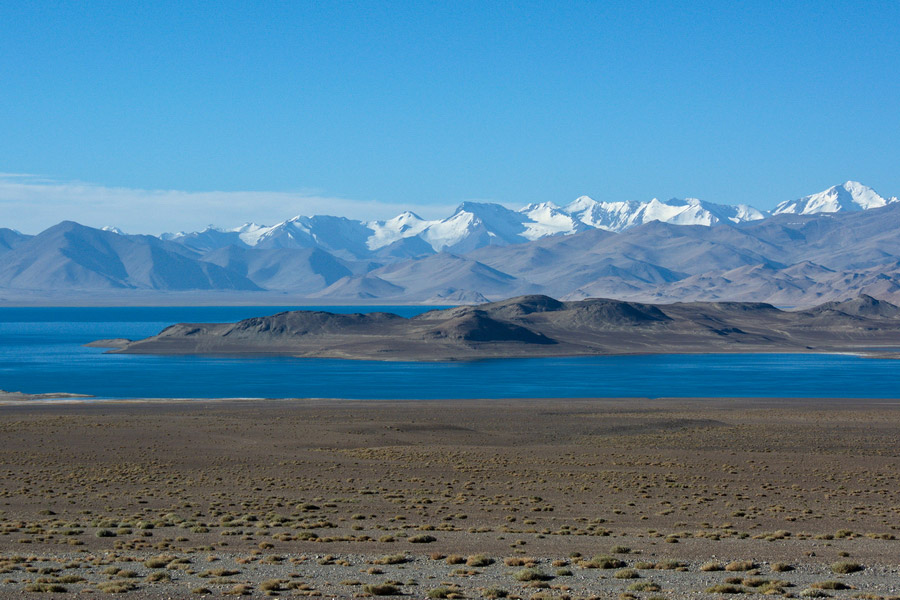
Karakul. This small, scrappy village, 63km from the border, is the only sign of habitation between there and Murgab. It sits on the lake and has 4 homestays. Osh-bound vehicles often stop here for breakfast, but beware of getting off here without your vehicle, as getting out again might take a day or two.
The whole area lies in the Unesco-listed Tajik National Park. Tickets aren’t needed if transiting or sleeping in Karakul. The landscapes are archetypical Pamir poster material with long straight stretches of road disappearing into stark, colourful mineral moonscapes, ringed with white-topped mountains in crystal clear air.
MURGAB. (pop 6500, elevation 3576m)
Utterly isolated, this wild-east town is the logical base to explore the eastern Pamirs. Think white box houses, crisscrossing power lines and rocky bone-dry ridges. 7546m Muztagh Ata, on exceptionally clear days, hangs on the eastern horizon. A meandering river valley below the main road level creates the area’s nearest approximation to greenery. Murgab’s population has significant Tajik and Pamiri contingents, contrasting with surrounding communities that are almost entirely Kyrgyz. This place has no electricity (power is solar for light only), ATMs or internet access. The layout is confusing: the upper road is the main Pamir Highway and the much lower road has the bazaar, petrol stations and a bunch of shipping containers. Other roads are bumpy dirt.
I arrived just as total darkness was enveloping the mountains. It was cold and windy and I got let off at Erali Guesthouse, the only homestay or hotel that seemed to be open. There are 3 sleeping rooms and I was put in the only one with a stove. I refused the stove being lit as I don’t sleep well if it is too warm. I put out my sleeping bag on the thin colourful mattresses lining the walls on the elevated sleeping platform. Colourful rugs lined all the walls.
Dinner consisted of a large bowl of fried potatoes, bread, butter, tomato sauce and a large pot of tea. Everything tasted delicious. The older Tajik woman said “Bon appetite” every time she brought food. I was not shown where the outside long-drop toilet was nor was given bedding, so after eating curled up in my sleeping bag and read. The hosts finally appeared, gave me a too-heavy quilt and couldn’t believe I was warm. I eventually had a great 11-hour sleep and woke up at 9 am, anxious about catching a shared taxi the next morning to Khorog.
Around Murgab. There are five potential places to visit in the area but I did not go to any of them as it was very off-season.
1. Madiyan Valley. Running west from the south end of Murgab, this valley has rugged rock walls set against green riverside pastures. 9kms up valley is a hot springs accessed by a dodgy bridge across the river.
2. Pshart Valley. Running west from the north of Murgab, it is parched with mineral layers. It is possible to do a 7-hour hike over to Madiyan via a 4731m pass.
3. Rang-Kul. Mountain deserts, salt lakes and sand dunes.
4. Shaimak. 126 km southeast of Murgab is the junction of Tajikistan, China, Afghanistan and Pakistan.
5. Shakhty. 50 km from Murgab, this cave has Neolithic paintings of a boar hunt. Unfortunately, you can’t enter the cave (so why go).
My hoped-for destination was the Wakhan Valley, accessed south from the Pamir Highway. The valley follows the Afghan border for its entire distance giving a seemingly endless parade of scenic superlatives. The 520km trip must be done in 2 days. It was made abundantly clear that there was no transport there other than private 4WD vehicles and hitchhiking was not a wise option. My driver quoted US$400 for the two-day trip to Khorog and after some negotiation dropped it to 350. There were no other tourists in Murgab to share.
After a quick breakfast, I made my way down to the bazaar and a hoped-for ride to Khorog. There were no share taxis visible and I was immediately hustled by a guy in a small truck. But he had business to do first and we headed up to his house to load the freshly butchered carcasses of 4 goat and 6 sheep. I was able to see the last goat killed and butchered, always interesting as these guys are so practiced. I was then invited in to the driver’s house where all the men involved in the butchering came for food and drinks. It was interesting to look around the room at the different facial features – the narrow, Roman-nosed, round-eyed Tajiks and the round-faced, small-nosed, slightly slant-eyed Pamirs and Kyrzyz. Two big plates of boiled mutton and fat appeared along with bread, tea and vodka. The lungs, heart, liver and thoracic fat from the most recent butcher were cut into small pieces fried up and placed on the mat. There were 8 of us sitting on the colourful rugs. The wife spoke some English and translated and there were lots of laughs.
After all the carcasses were loaded in the back, we picked up a middle-aged woman passenger from Osh on her way to visit her parents and finally headed out at noon. There were some obvious mechanical problems with the truck in town and our luck ran out in the middle of nowhere. Two vehicles stopped to help, tools were used, spark plugs were removed and several attempts at pushing to jump-start the truck all failed (I am sitting in the truck writing all this as the driver attempts to get things going). It seems the problem is with the gas tank, now removed along with the rear wheel and on the ground to give access. I eventually got out my pack, warmer clothes and sleeping bag and bundled up with the woman in the back seat. We have water and some food so shouldn’t freeze to death even though the temperature is well below zero. Nothing beats shit happening. The fuel filter or fuel pump got fixed and we were on our way again. A while later, when we pass some trucks, our driver is hailed down as gas is leaking on the ground. Again, the wheel comes off and the leak is fixed. We finally make it to Alichur, another village on the road. Our driver disappeared apparently to get gas. We ate and then waited for about 2 hours in the café. I started to think the worst – that he had left town and absconded with all our stuff when a guy came along in a jeep, picked us up and took us to his house where the back wheel was off again and our guy was at work on the vehicle again. So after 6 hours, we are only about a third of the way to Khorog, normally a 6-7-hour drive.
Every time you enter a house, hospitality is forefront. Here in this remote place, tea, bread, cookies and soup appeared. It is precisely like every time we entered a yurt in Mongolia. Or visited one of my farmer aunts in Southern Saskatchewan.
So we continue on and it is soon dark and the road deteriorates into rocky dirt as it goes over Kol-Tzezek Pass (4272m). Any pavement is broken, frost-heaved and pot-holed. There must be a full moon as I could see the surrounding mountains – not much has changed the whole journey – rocky desert and forbidding rugged mountains.
At one hundred kilometres from Khorog, the truck broke down permanently and we were left on the side of the road at 10 pm to hitchhike. Several vehicles refused and then three young guys in a car picked me up. I wondered what I had gotten myself into – blaring music, interminable questions in Russian and lots of vodka. I can’t believe that regular cups were being passed to the driver who thankfully spilled as much as he drinks. We eventually made a detour over a very rocky back road to the driver’s mother’s house and picked up the driver’s wife and two children. I put my pack into the trunk next to the live sheep also in the trunk. After several more kilometres where the guys were behaving themselves, we stopped at a store and they broke the padlock on the door and entered. They must own the place (and not have a key) because his family stayed there. We then went on another back road, dropped off the sheep and the drunkest guy and picked up a young woman. Back on the highway, it was a mixture of broken potholes and gravel and the guy is driving at top speed with nobody wearing seat belts as there weren’t any. We eventually arrived in Khorog at 2 am and the search started for a gas station, none were open and the guy extorted 120 Sonomi from me. They stopped at a gas station and left me alone next to the car (don’t ask me where they went). So I got tired of waiting and started to walk as there were no taxis, to find a hotel. The first place was closed, the second was full and I decided to walk the few kilometres to my first choice of a place to stay, Pamir Lodge. A car stopped and asked if I needed a ride and he drove me right to the hostel – I never would have found it on my own. So I arrived at 3 am and everything was dark. There is an outdoor sleeping space with mats and a pad and I put out my sleeping bag, but am so hyped from the wacko day, that I lay awake for an hour.
KHOROG. (pop28,000, elevation 2100m)
Pamir Lodge is a great place to meet fellow travellers and there are many here: two Thai women on an expensive 3-week trip, a single German woman on a bicycle (the Pamirs are one of the premier cycling destinations on the planet) and a single Korean man and a single Japanese woman. The last two have rented a 4WD to see the Wakhan leaving at 10 am at a great price, so I arranged to join them. What a lucky break because this is what I wanted to do. An Australian guy appeared and joined us too to make it a very economical adventure. The Korean guy works for an NGO in Dushanbe and speaks fluent Tajik, so we have a built-in guide and translator. They have planned some side excursions and intend to go to Murgab and return on the Pamir Highway, so I decided to repeat that part of the trip. I saw most of it in the dark and it would be nice to see it in daylight.
Lying under arid, barren rock peaks, Khorog is the GBAO’s administrative centre and the Pamir’s only real town. It’s the best place to meet fellow travellers and organize trips into the surrounding mountains especially the Wakhan, the main destination in Eastern Tajikistan. Chartering 4WDs here is easier than anywhere else.
Khorog has one of the best-educated populations of any town in Central Asia. English seems much more widely spoken here than in Dushanbe, while the laid-back Ismaili form of Islam means that Islamic strictures are generally less likely observed.
Although at an altitude of over 2000m, Khorog’s summer temperatures sometimes reach the 40s. September is the best month here.
There are few sites per se: a Soviet-style museum, a nice Central Park, a botanical garden with good views and on Saturdays, a colourful Afghan market where border guards allow folks from both sides of the border to trade in a special penned area.
THE WAKHAN CORRIDOR
Our young driver has a Toyota Land Cruiser, a great vehicle. Irritatingly he plays terrible loud techno music but the Australian oddly says that it is the driver’s choice and we have to put up with it for 4 days (I thought we were the customers). The windows are tinted and it is too dark to read in the daylight. He also drove like he was in a car rally. We survived only because there was so little traffic coming the other way. I ask the Japanese woman sitting in the front seat why she doesn’t use her seat belts. “The driver isn’t using his.” She is using a film camera with Ektachrome 400 to take photos while we drive and the roads are very bumpy – go figure.
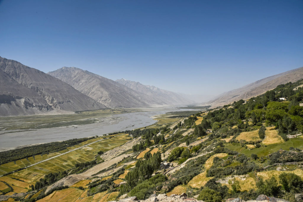
This wide river valley forms the border of Tajikistan and Afghanistan. Tall mountains rim the valley with the dazzling Hindu Kush in the background and forms the Afghanistan/Pakistan border.
Khorog to Ishkashim. This 100km stretch starts with the river raging through a narrow canyon. The road on the Afghan side seems close enough to touch. Near Ishkashim, the river widens with pretty meadows and fields. Near the town of Anderob are ruby mines first recorded by Marco Polo in 1274.
We stopped in a village to visit friends of the Korean fellow. Just as we arrived, several brick walls started to collapse and people came running from their houses. Huge rockfall and dust clouds covered all the mountains in both Kyrgyzstan and across the border in Afghanistan. We were thankfully far from the epicentre of the 7.7 earthquake centred in Afghanistan. Everything is made of rock here, tenuous in an earthquake, but not much damage is done – several rock walls are down and plaster sprinkled the floors. Many died in Pakistan. We went up to his friend’s house for more of the same great Tajik hospitality. The grandfather is 91 with a full white beard and twinkling eyes.
Ishkashim is the Wakhan’s regional centre and largest village. There is not much here other than a famous trans-border market held 3 km west on Saturdays, but it has not operated for many months because of Taliban insurgencies in the area. A passport was required but no Afghan visa, and I was very disappointed to not have an opportunity to add another country to my list. When we passed the gated bridge, two Tajik soldiers waved when they saw cameras as no photos are allowed.
Ishkashim to Langar. This part of the road has the Wakhan’s greatest appeal. Poplars, many villages and arid valleys frame white pinnacles and glaciers across the river on the Afghan side.
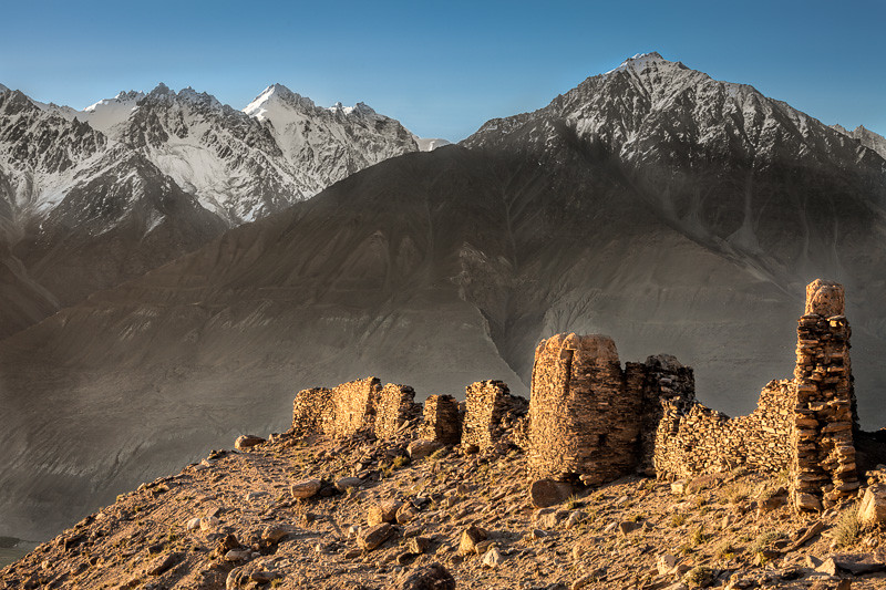
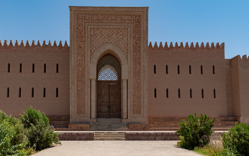
Kakh-kara Fortress, 15km east of Ishkashim, has a series of mud-brick wall fragments on top of a hillock beside the road. The oldest sections date to the 3rd century BC, but the site has been reused by many cultures since. It was built to defend parts of the Silk Road that went through the Wakhan Corridor. Gravel pathways make exploration easy.
We drove up above the snow line to Bibi Fatima Hotsprings (named after the Prophet Mohammed’s daughter). Bring a towel but no bathing suit is necessary in the sex-segregated pools.
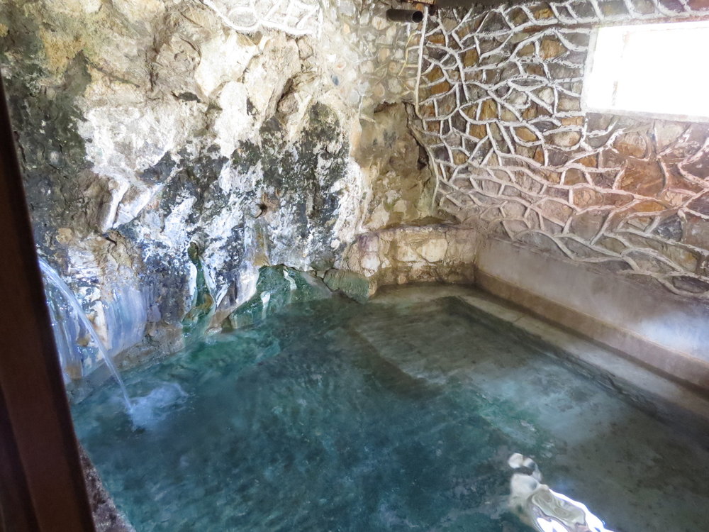
After a great soak, we stayed at a nearby guesthouse high above the wide valley with the braided, meandering river far below. The houses are lovely: low, flat-roofed affairs with white plastered exterior walls – very similar to the adobe of New Mexico without protruding roof beams. The insides are glorious: colourful patterned rugs on the walls and floor and sleeping platforms encircling the room. A central skylight framed by massive beams in a pentagonal pattern makes them bright spaces. The rest of the ceiling is open beamed timbers with thin debarked branches filling the spaces.
When I woke up at 3 am, the Hindu Kush was bathed in bright moonlight (it was a full moon). At 7 am, I watched as the peaks were progressively hit by the sun on a clear day. After breakfast, we drove back up towards the hot springs to see Vamchun Fortress perched on an impossible rock outcrop. Occupied between the 3rd and 1st centuries BC, many of the walls remain. One rounded tower has many ports. It is hard to understand the need to build something this high and remote – the valley below must have been a dangerous place to live. The river is a lovely turquoise.
Some of the valleys coming out of the Hindu Kush have trees, fields and a few houses. Otherwise, the Afghanistan side is desolately uninhabited.
Continuing up the Wakhan, the road turns to hard-packed gravel and bits of pavement in villages. Amazingly, Afghanistan is only the valley on the other side of the river and a narrow sliver of the Hindu Kush, with the majority of the mountains in Pakistan. The road is lined with rock walls, tiny collections of houses, wandering men, sheep, goats, cattle and donkeys.
Langar. Here the Pamir and Wakhan river valleys meet. The Wakhan is huge and wide extending east next to Pakistan. There is not much in the town other than a collection of (supposedly) 6000 petroglyphs high above the town. We hired a guide for 30 Sonomi to show us the way. It is a steep 20-minute climb past a Muslim cemetery (most gravestones have pictures of the occupant) to a large area of sloping granite.
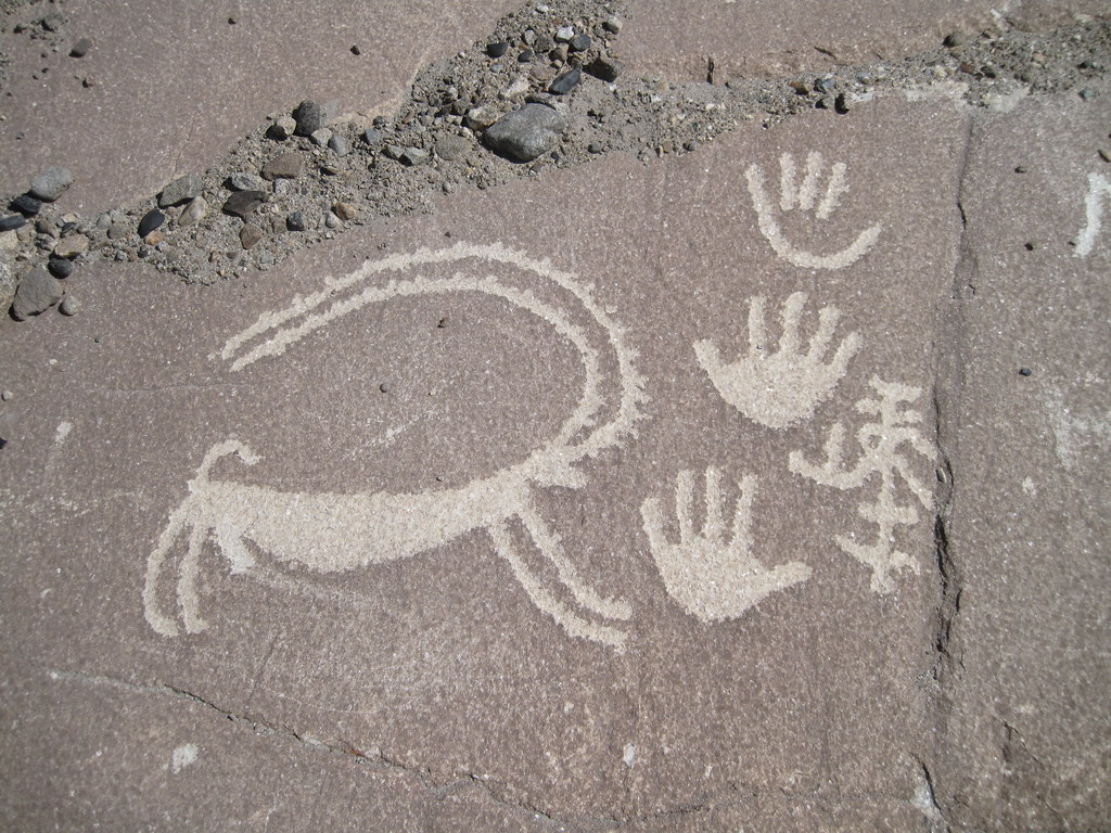
I found them quite disappointing as 90% of the ‘petroglyphs’ are recent and simply people’s names. The rest are older (our guide did not know their age) and almost all of these are poorly executed Marco Polo sheep. The few that are not were of a figure with a shield and headdress, some multi-story Islamic buildings and a very nice sheep next to some good handprints at the very top of the rock.
Langar to the Pamir Highway. At Langar, the single-lane gravel/dirt road climbs high above the Pamir River (now the border between Afghanistan and Tajikistan). Set in a steep-walled gorge, only one glimpse of the river itself is possible. A well-constructed path is across the valley and we saw a caravan of 9 camels and 5 horses stopping at 2 mud huts. A little further were 3 men on horses. It is not obvious where these guys are all headed as the country is so desolate. Eventually, the road followed right next to the river and we were only 30m from Afghanistan. Even though we have not set foot in Afghanistan, it feels like we have been there most of the trip.
The valley eventually widened and the high mountains became rounded hills as we approached the military checkpoint at Khorgosh, 70 km from Langar. Sitting beside the road in the subzero temperatures were the Australian couple I had met not far from Murgab 2 days before. Here the road swings north away from the river, passes through the Zorkul Nature Reserve centred on Lake Zorkul (which protects the breeding site of bar-headed geese) and crosses 4344m Khorgosh Pass before descending to the Pamir Highway. We saw some large herds of sheep and goats but not one farmhouse since Langar.
We turned west for a few kilometres on the highway and then north off the highway to go 14 km to Bulunkul (3737m), an end-of-the-world village set in the middle of a vast open valley ringed by low mountains. It is a friendly but unesthetic three-row grid of low-slung, wind-blown houses. We drove 4.5km to the east side of the mirror-like Lake Bulun-Kul. The main attraction here is Lake Yashil-Kul, a much larger lake a few kilometres north over a low pass. A hot spring covered by a ramshackle building is on the south shore. A shallow pool feeds the moderately hot water through a pipe into a bathtub. It was cold, and I had a quick dip. Reportedly Bulunkul is the coldest place in Tajikistan. I can vouch for that as it must have been at least -20° during the full moon, cloudless night. The foul, single-hole long drop toilet was a test. Our sleeping room had a nice dung-fuelled stove in the corner so we all survived till the morning.
On day four, we returned to Murgab. Transportation north was arranged for the Australian fellow (continued to Sary Tash, Irseshtam and Kashgar, China; he eventually continued to India to continue his Ph.D. studies in Punjab) and the Japanese woman (continued to Osh, Bishkek, and around).
The Korean fellow and I tried to arrange a short trip to Shakhty, 50 km from Murgab, a cave with Neolithic cave paintings. But with much discussion and difficult translation, it became apparent that we weren’t allowed in the cave, so did not go. In Murgab, as we are to leave, our driver demands more money, despite being well paid (US$500 for 4 days). We thought we had a clear understanding that the trip would end in Khorog. It is only after a phone call to Pamir Lodge in Khorog that he relents. I am losing faith in the Tajik people. Instead, we continued to Jelandy, about 3 hours from Murgab over Kol-Tzezek Pass (4272m) on the Pamir Highway. Here we stayed at a homestay with hot springs in their house. One enters through their living room, passes through a greenhouse full of tomatoes and peppers and enters the hot springs. There was a good shower and the springs area was in an attractive inside pool. There was a slight sulphur smell but they were very nice. All their heat is from the hot springs so our room is too warm – for once.
At Jelandy, we picked up 5 extra passengers. Despite having paid for the entire vehicle, complaints went nowhere. But it was a gorgeous drive on a perfect cloudless day. Snow covered the upper mountains and they only got better as we approached Khorog.
KHOROG (again)
The Korean fellow left for Dushanbe as soon as we arrived on October 29th, and I elected to stay at Parinen Inn on the west end of town rather than Pamir Lodge at the far southeast part of town. Pamir Lodge is a great place to meet fellow travellers but the beds are hard (actually rock), the rooms unheated, and the facilities mediocre for $9/night. Parinen Inn was full when I arrived, but was given a bed in the ‘conference room’, a large space lined with large comfy chairs for $15/night. It is heated, has a nice kitchen with free coffee and tea, a lovely garden/orchard with a pigeon house, clean modern bathrooms, and a young guy with great English. It is also close to the shared taxi stand in Dushanbe and downtown Khorog. I don’t think the choice was hard to make. Plus I have had enough contact with other travellers to do me for a while and some peace would be welcome.
Central Park. Right on the river, this elegantly designed park in the middle of downtown Khorog is a lovely place to stroll and hang out.
Regional Museum. Right in downtown Khorog, this is quite lovable. There are lots of neat old things and it is free.
Botanical Gardens. 5kms east of town, they are at the end of Marshrutka 3’s route. The driver soaked me 5 sonomi for the trip when the cost was only 1.5 (no wonder he was smiling) One more reason to suspect Tajiks. They are high above town on a plateau so it was good exercise getting up there. It is a walk in the woods as all I saw were trees, but there is an amazing variety with 2300 species, all labelled in Latin and Tajik. I walked on the paved road past several buildings for tremendous views down onto the east end of Khorog. At the far corner were 2 spectacular mansions and I wondered who lived in them. There were many visible trails across the surrounding hills and this would be a great place to hike.
Nearby is Delhi Darbar, a hotel and restaurant with very good Indian food. It also is the only place in town with reasonable wifi so after wrangling the password from the owner, I caught up on all my emails, and blog posts and downloaded some books on my Kindle (I am making my way through the “Best Fiction Since 2000”, a readers poll in a British magazine). I subsequently ate every meal here. Also here every night were 2 Canadian dentists doing volunteer work in Khorog. Their boss is an RN from Calgary who has been here for 2 years. A great Canadian connection.
In the restaurant, I met two Germans with a real problem. Their Tajik visa was expiring that day and going past your visa date is serious business in Tajikistan. The fine is 400€. They were attempting to adulterate their visa and GBAO permits but I think that would be more serious. Interestingly they had taken a helicopter to Khorog from Dushanbe but waited 3 days to get a full load.
On my last day in Khorog (Halloween), I went to Sheghnan, Afghanistan, just across the river from Khorog. Read my post about the great day I had.
Up early the next day, I caught a shared taxi for the 14-hour trip to Dushanbe.
Khorog has been very warm during the day but the nights get quite cold and I wear a fleece and down jacket. Even though this town has a liberal form of Islam, it is very conservative by our standards. The town gets quiet after 6 pm and completely shuts down by 8. You can’t get gas or even water – there is nothing open. There certainly aren’t bars or nightclubs (like in Bishkek). I had a 15-minute walk home from Delhi Darbar, the Indian restaurant I have been eating at every night. There were few streetlights and the main street is quite dark. Only the occasional person was walking around and there were few cars. Khorog drivers are interesting – they swerve towards you and scare the hell out of you.
KHOROG TO DANSHUBE
On November 1, I caught the 13-hour share taxi to Dushanbe. All of them leave from the same stand with 6-8 vehicles competing for rides at the same time, not leaving until they are full. It is an expensive ride at 300 somoni or $48. There is a northern route (which goes over a 3252m pass and is closed from the end of October to May) and a southern route, our choice. There are many passport checkpoints along the way.
It is a wonderful drive following the Afghanistan border through a spectacular steep-walled canyon for 8 hours. The road is part asphalt, part bone cruncher. I made sure I had a left-hand middle seat so there were great views across into Afghanistan. A narrow, raging river divides the Tajik road from a precarious foot-path-track on the Afghan side, linking hamlets of stone and adobe houses set among small fields surrounded by rock walls. The Afghan road is a marvel of construction with many blasted sections across rock walls and sections that exist only with the support of long sections of rock. Many Afghans were walking with the occasional motorcycle.
At 65 km, the Bartang River is crossed. This valley is one of the wildest of the Western Pamirs with only occasional splashes of green amongst the barren rock walls. 4WD is required to get past Jizeu, a great short-hike destination.
The valley widens at the mouth of the Vanj Valley that leads to the Fedchenko Glacier, one of the world’s longest (a full day out-and-back hike from the end of the road). At Kalai-Khum, the northern route to Duchanbe takes off.
Between Rogak and Khostov is the most appealing stretch of the road. Across from Yakhchi Hisor Springs is an Afghan-side village with a series of houses perched on rocky riverside outcrops. After passing an Afghan border bridge, the valley opens up before turning west and climbing to the modest 2200m Shurabad Pass. I was lucky to have seen the best part of the trip here as it became dark and started to rain. We ate at Kulob, Tajikistan’s 3rd largest city. 30kms farther, at Vose is the startling 11th-century reconstructed Hulbuk Fortress Palace (I didn’t see this).
It is possible to fly but why would you want to? The 45-minute flight is either the most exhilarating or terrifying experience possible as the plane scoots between (not above) mountain valleys. In Soviet days, this was the only route on which Aeroflot paid its pilots danger money. Happily, the flights are grounded at the first signs of bad weather or unhappily, if there are insufficient passengers to fill the plane. Book an extra day or two in case flights are cancelled.
I arrived in Dushanbe at 10 pm in pouring rain.
DUSHANBE (pop 600,000, elev. 800m)
The capital of Tajikistan is a city in rapid transition. Its long tree-lined central avenue is lined with a collection of pastel-hued neoclassical buildings from its Soviet past. There is a whole new gamut of glitzy, oversized government buildings.
History. It was a small, poor village until the 1920s. Its name means Monday, the day of its weekly bazaar. The railroad arrived in 1929 and it was made the capital of the new Soviet Tajik Republic. By the 1950s, the population was greatly swollen, initially with Tajik emigres from Bukhara and Samarkand, then during the 1940s with 50,000 Germans, both POWs and Soviet-Germans exiles from Russia. Dushanbe developed as a silk and cotton processing, industrial and administrative centred.
As the USSR crumbled, riots and demonstrations in the civil war resulted in armed gangs controlling the streets. Since 2002, it has transitioned to a calm, prosperous city.
I decided to splurge and treat myself to a nice hotel, the Tajikmatlubot. The quoted price was $50, I bargained down to 40 and after saying I would stay for 3 nights, paid $30/night. Each room is a veritable suite. With good wi-fi and 5 English news channels (the best is Aljazeera), I have had a chance to catch up on the news, my website, play bridge online and read. The hotel is very close to both the Turkmenistan and Uzbekistan Embassies, both countries with a needed, and cumbersome, visa process.
Turkmenistan did not issue any visas for the whole month of October because of military exercises and I was not optimistic. The 5-day transit visa does not require a letter of invitation or an expensive tour. I met some young New Zealanders who had taken 2 weeks to get theirs. But despite not having the required Uzbek visa nor a visa or flight for my ongoing country, they said that my visa would be available in Tashkent in one week! Go figure.
I had also paid $85 for my letter of invitation for my Uzbek visa and it arrived after 8 days and I then obtained the visa in 4 minutes for $65 (but unfortunately did not change my original dates, a possibility at this stage). Things were looking up. Getting visas on the road instead of at home suits my travel style much better, as one is not fixed to a set itinerary and all these visas are date-specific. Getting them in your home country is only easy when you live in a large capital city where all the embassies are. If not, then one must use expensive agencies, mail passports and take a huge amount of time. So I ended up with an afternoon to see all the sites in Dushanbe.
Writer’s Union Building. Tajikistan’s Persian past is invoked on the façade with saintly sculptured stone figures of all their great writers and poets.
World’s Biggest Teahouse. This was a long walk out of my way, but I had to see it. And it is a monster with two 40-foot-high floors. It could hold 200? 500? normal tea houses but I was barred from entering unless I wanted to go to a 3D theatre. I don’t even know if it contains a tea house.
National Museum. In a grand building with an airy atrium that looks like a giant cement mixer, it has 4 floors of airy galleries. Dioramas with stuffed animals are stuffed with animals. Besides the usual archaeology, there is an exhibit of all the gifts to Karamov, mostly from Middle Eastern countries, a nice display of gold and a gallery of contemporary art.
World’s Tallest Flag Pole. At 165m, it is. And I thought N Korea had the highest one, but it does not come close. It was too bad that there was no wind as I wanted to see what kind of breeze would unfurl the world’s biggest flag. The pole is set in a big fountain/statue park surrounded by grand government buildings.
Rudaki Statue. It is under an impressive blue tile mosaic arch in the park.
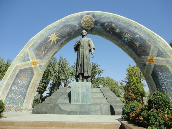
Statue of Ismoil Somoni. The 10th-century founder of the Samannid dynasty’s statue stands under a giant crown-topped arch.
Parchan. A gold emblem of Tajikistan on a white-marble column.

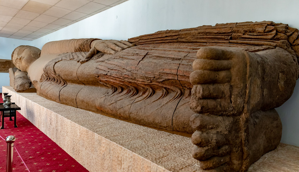
Antiquities Museum. With an excellent archaeology collection, you can see the originals from which copies were made for the far gander new National Museum. Notably, the 13m-long sleeping Buddha here is the real one that moved from Ajina Teppe in 1966, when Soviet archaeologists sliced it into 92 pieces. Dating from the Kushan era (around 500 AD), it is the largest known Buddha figure in Central Asia.
Labeling of the exhibits is erratic with some in English and many unlabeled. I was the only one in the museum and one of the 7 women working here followed me around turning on lights in the galleries. If desired, this would be a great place to pick up women.
After seeing another musical instrument museum and the two major religious buildings (St Nicholas Orthodox Cathedral and the Mevlana Yakub Charki Mosque), I’d seen most everything there was to see in the city.
I ate at the two foreign restaurants in town (Tajik food is not memorable). The Italian restaurant, supposedly the best in town, was also not memorable. Imagine a Caesar salad with no garlic and an Italian restaurant with no pizza.
If you are going to Uzbekistan (where the money black market demands you bring all your money in US$), make sure you acquire as much as you can before coming to Dushanbe. None of the ATMs dispense US$ and few money-changers have any. Even though many places state their prices in US$, they give change in somoni and don’t expect $. I made the mistake of paying my hotel bill in $ and couldn’t get any more. The only luck I had was from some British tourists who sold me 150$ worth. So I spent my last day in Dushanbe running around trying to find more.
I finally found the right money changers near the TsUM Mall and bought $400US. A city bus goes to the shared taxis heading north at the Cement Factory. I found a driver going directly to my final destination, Lake Iskander-Kul in the Fan Mountains, NW of Dushanbe. It took 2 hours to fill the car and they never leave with a space open. He was another intense rally driver. They never wear seat belts, are on their cell phones constantly and play loud music (think fast polka).
Right after leaving the city limits, the road climbed into some dramatic, craggy mountains, the Hissar and Zerafshan/Fan mountain ranges. There were many snow sheds and one outrageous, foul, nightmarish, 5km long tunnel with sudden unlit lane closures that traversed 3372m Anzob Pass. It took 2 hours to Svoboda and then, after a short backtrack, 24kms SW to the lake. We had let out the other 7 passengers by then but picked up his very cute 4-year-old granddaughter. Unrestrained in the back seat, he drove just as aggressively.
Lake Iskander-Kul (elev 2195m) and the Fan Mountains. The highway to the Sarvoda gives good hints at the magnificent glories behind. The easiest access to the Fan Mountains is this lake, an opal-blue with a superlative mountain backdrop. After passing through a few villages, the road climbs through a canyon of dirt and soft rock coloured in a palette of tans, pinks and reds all riven into eroded pinnacles. Jagged ridges of snow-capped mountains rise above. The view is especially dramatic 1.5km before arriving at the lake, before the road descends to the lake.
The rugged, glaciated Fan Mountains are one of Central Asia’s premier trekking destinations. Studded with dozens of turquoise lakes and high-mountain vistas. A good resource is trekkinginthepamirs.com.
I was fortunate to have found this driver as I doubt that I would have found a ride up here otherwise. My first choice of a place to stay, Shezok, was closed so I was let off at Turbaza Iskanderkul, a collection of 50 four-room, Soviet-era cabins in some woods. This is the action spot in the summer. Most trees had plasticized signs “toilet⇒, “On the lawn do not walk” or “Dining Room⇒”. But the lake is always too cold to swim in. I was the only guest in the place or for that matter anywhere up here. The proprietor spoke no English so it was all sign language. I asked if there was a place to eat, and he said nyet, then recanted and said that dinner would be in an hour. I hadn’t thought of bringing any food or water (but had some old bread, butter and an onion in my pack).
I went for a walk around the village of 5 or so houses at the east end of the lake with all my warm clothes on and returned to the lake shore. The electricity came on at 5:45 so I had light and heat from a barely adequate portable heater. He came around at 6 and I went to his house for dinner. There was another guy there, both in their early 50s (they all look 10 years older than they are) in a small room with a stove, 3 beds, some shelves, a table and of course a TV. He served a simple soup with bread, tea and hard-boiled eggs. I gave him the large piece of meat/bone, he gave me a piece of potato. After a lot of bread dipped in the soup and two eggs, we talked a little. I told them where I had travelled. Place names are the same in any language. Hand signals work. I bought some water and came back to the cabin. I then curled up in my sleeping bag, wrote about my day, watched a movie, read and went to sleep very early. What more could anyone want?
The next morning, I went over for breakfast of fried eggs, bread and my own coffee at 7 (total price for the room and food 80 somoni) and then walked 9km up to Sarytag village, the best base for further treks. There I was to meet Makmoud who would be able to give me a ride back down to Svoboda. It was 50 minutes around the lake where the opulent President’s dacha is (helicopter pads, gorgeous grounds, all-glass front, high wrought iron fence). After walking up the valley, there is a choice of 3 roads: one to the left with 19 switchbacks to a microwave tower and another more gradual to the right of the river and I guessed was right. Across the valley below the tower appeared a village and I was sure I had gone the wrong way (how many villages are there up here?), but I persisted and at the top saw some houses. This ended up being the right way. About 200m before the first house, I met a vehicle crammed with 4 men and sacks of empty vodka bottles, a season of drinking. One guy spoke reasonable English and told me Makmoud had already left early for Khojand, so I piled in, picked up my pack and drove down to Svoboda (40 somoni). On the way we passed one of the guys I had eaten with riding a donkey down to town. It only took 10 minutes for a shared taxi with one space to come by, so by noon I was onto Khojand 200kms away (100 somoni). Put into a middle seat, it took some explaining that I was a tourist and wanted a view, so changed for a window seat. All the trees were in lovely fall foliage of yellows and oranges.
The road descended through the Turkestan Mountains that slowly petered out to low hills and then the huge flat expanse of the Fergana Valley (which doesn’t look like a valley at all). Cotton became the dominant crop.
KHOJAND (pop 164,000)
Tajikistan’s second largest city is a massive sprawl with the centre south of the Syr-Darya River. As the entrance to the Fergana Valley, it had palaces, grand mosques and a huge citadel before the Mongols bulldozed the city into oblivion in the early 13th century. Secure behind the Fan Mountains, it managed to escape the ravages of the civil war and remains the wealthiest part of the country. It has a large Uzbek population and a concentration of Tajikistan’s Soviet elite.
I stayed in the uninspiring, but cheap Hotel Leninobod. A Soviet tower with only the first two floors occupied, it has evolved little since 1990. There is no wi-fi and heat is provided by inadequate ancient plug-in heaters. A sullen floor lady rules the roost but will provide hot water from her room. So I decided to stay only one night, see a few sites and leave in the morning for Uzbekistan.
WWII Monument.
Sheikh Massal ad-Din complex. This religious complex has a 1394 brick mausoleum of Sheik Massal ad-Din (1133-1223) with carved wooden doors, a 20th-century mosque with wonderful carved and painted ceilings, a 21m-high brick minaret dating from 1865 and a new brick mosque with a lurid emerald-green dome.
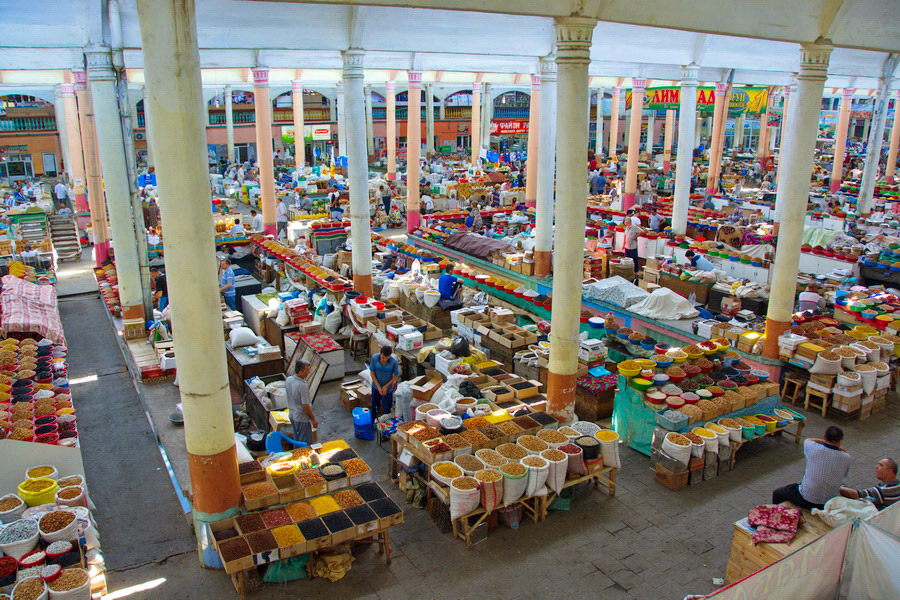
Panchshanbe Bazaar. This wonderful bazaar was purpose-built in 1964 with an arched portal. It is one of the best-stocked markets in Central Asia – every vegetable and fruit under the sun, aromatic spices, nuts, bread and all manners of food. The variety of redolent smells was lovely.
Citadel. Originally the site of Alexander the Great settlement, a citadel was built in the 10th century with 7 gates and 6kms of fortifications. The eastern wall has been rebuilt but the citadel itself cannot be entered. A museum with wonderful marble mosaics depicting Alexander’s life is the highlight.
Unfortunately, as I was leaving, I realized that my wallet had been pickpocketed from a zippered front pocket. I have had inside pockets sewn into all my pants but use them only for money, so lost only two debit cards and my Visa card. But this year I am prepared, have extras and so am not hopelessly lost. Although valuable, they are fairly easily replaced and will have them sent to a hostel in Dubai where I will be in 2 weeks. There was no money in the wallet. This is a reminder to always use your inside pockets for everything – pickpockets are very talented.
I tried to find wifi to Skype Visa for replacements, but I don’t believe wi-fi exists in Khojand. I will be staying at a hostel in Tashkent, Uzbekistan for 2 days so will deal with the issue there. I saw the few sites in Khojand by 9 am, picked up my luggage, took a 20sonomi taxi to Isfara Avtostanitsa, the minibus stand on my way east to Kanibadam/Kanibodom on the Uzbekistan border, then on to Kokand, Uzbekistan. I have my visa and US$650 so should have enough money to exchange on the black market.
Summary of Tajikistan. I enjoyed this the most of all the ‘stans. It has great mountains and rivers and some of the best road trips on the planet: the Pamir Highway, the Wakhan, Khorog to Shurabad Pass and the Fan Mountains – all jaggy, craggy peaks with snow. I drove the Tajik/Afghanistan border for 3 days and went to Afghanistan for one day (the easiest access is from Tajikistan).
