
Kazakhstan Oct 5-18
This is the world’s ninth biggest country and the most economically advanced of the ‘stans’, thanks to its abundant reserves of oil and minerals. However, the drop in oil prices has affected it significantly. It means better accommodation, restaurants and transport than elsewhere in Central Asia, but also much higher prices. Besides its two big cities of Almaty and the capital, Astana, the best travel adventures are in the high mountains and valleys of the Tian Shan. It is famous for oil, steppe and Borat.
The website www.caravanistan.com is a wealth of information on all Central Asian countries.
Area. 2.7 sq km
Population. 17 million
Money. The tenge (T) was worth in October 2015, 270 to the $US (153 in 2013).
Visas. Citizens of the following countries do not need a visa to visit Kazakhstan: Argentina, Armenia, Azerbaijan, Belarus, Ecuador Georgia, Hong Kong, Kyrgyzstan, Moldova, Mongolia Russian Federation, Serbia, South Korea, Tajikistan, Turkey, Uzbekistan, and Ukraine.
20 countries get visa-free for 15 days: the United Kingdom, United States of America, Germany, France, Italy, Malaysia, Netherlands, United Arab Emirates, South Korea, Switzerland, Spain, Belgium, Hungary, Monaco, Singapore, Australia, Norway, Sweden, Finland and Japan. In early November 2015, 15 more countries were added to this list including Canada. Go to the official government site to see the complete list: www.mfa.kz/en/consularissues.
Several other countries do not need a letter of invitation. If you are not a national of one of these countries, or you want a different type of visa, you will need a letter of invitation (LOI) from a Kazakh tour operator.
From the Kazakhstan border, I was given a ride 280 km to the door of my hostel in Almaty! Otherwise, it looked like I would have been sleeping outside because there was no other traffic. Marhabat was unbelievably generous. He even bought me supper (with many shots of vodka). On the way, we stopped at the large vegetable stands beside the road and completely loaded the roof rack: two banana boxes of tomatoes, large bags of red and green peppers, garlic and carrots. Making their delicious tomato/pepper-based sauce is a tradition in the country. We then stopped at his farm. A physician, he runs a lab here where he researches vaccines. The couple living on the farm put on an unbelievable spread of bread, two varieties of sauce, two types of homemade jam, garlic pickles, pickled vegetables, endless milk tea and of course more vodka. It reminded of the endless spreads put on by some of my aunts, also farmers, when a child in Southern Saskatchewan.
Southeast Kazakhstan is known as Zhetisu (Land of Seven Rivers) as it has more than 800 rivers fed by the glaciers in the mountains along the Kyrgyz and Chinese borders. This is the area I drove through between the border and Almaty.
Charyn Canyon. The road crossed this 150-300m deep canyon some 200 km SE of Almaty. There are weird and wonderful rock formations, especially in the branch canyon known as the Valley of Castles.
Karakara Valley. This is the valley the road follows between the border and the town of Kegen and continues on into Kyrgyzstan. It is beautiful and broad and an age-old summer pasture for herds of horses, cattle, donkeys and sheep.
ALMATY (pop 1.2 million, elevation 850m)
This leafy city with a backdrop of the snow-capped Tailysky Alatau, has always been among the most appealing Russian creations in Central Asia. Its new rich have expensive apartments, large SUVs, glitzy shopping malls, coffee shops, expensive restaurants, nightclubs and new ski resorts. Great hiking and skiing are right at its doorstep. It is Kazakhstan’s main transport hub.
History. It was founded in 1854 when the Kazakhs were still nomads, as a Russian frontier fort on the site of the old Silk Road oasis of Almatu, which had been laid waste long before the Mongols. Earthquakes flattened it in 1887 and 1911. In 1927, it became the capital of Soviet Kazakhstan. The Turkestan-Siberia railway arrived in 1930 and brought big growth – as did WWII when factories were relocated here from Nazi-threatened western USSR. Many Skavs and Koreans arrived.
In the 1970s and 1980s Kazakhstan’s leader, Kunaev, the only Central Asian member of the Soviet politburo, steered lots of money here. In 1991, Almaty was the venue for the meeting where the USSR was finally declared dead. It was replaced by Astana as the capital in 1998 but remains the country’s business, social and cultural hub.
Bicycles, scooters and buses are not used much in this vehicle-crazed town. But they are very respectful to pedestrians, almost as nice as Canadians which says a lot. Even taxis are uncommon and many get around town by hitching.
The hostel I am staying in, Five Seasons, is relatively new and a nice place. When I arrived, I was put into a 6-bed dorm, but there was a Russian fellow who had been drunk for the last month, the sour smell of booze was overwhelming, and I asked for a different room. I was put into a room with 4 single beds and the only other occupant was a young university student who was living there for the year. Like almost everyone that age, he stays up till 1-2am and then fights his alarm the next morning. Just after arriving, I experienced the most violent occurrence of my life. A big Russian guy started to beat the living snot out of the drunk Russian. After hitting him in the face 10x, he proceeded to kick him in the face a couple of times!! Apparently, he was owed money.
Central State Museum. Almaty’s best museum (300T, 1,300T with the gold museum), it has the usual ethnographic history, archaeology, and the ‘Open Collection” and exhibit of outstanding ancient gold adornments, mainly from Scythian burials between the 6th and 3rd centuries. Most of the signage in nonlocal languages is limited to ‘Don’t Touch, Please’.
Kok-Tobe. This 1100m hill on the city’s SE edge is crowned by a 372 m-high TV tower. After walking to the cable car entrance closed for renovations, I walked most of the way up the road that gives access and then took the shuttle bus to the top. You cannot access the tower but on the hill are an amusement park with kitschy rides, a zoo, restaurants and reasonable views of the mountains and smog below. I stayed for sunset and views of the city at dark.
Panfilov Park. This large, well-treed park is Almaty’s most popular strolling and hangout place. It is named after 28 soldiers of the Almaty infantry who died fighting Nazi tanks in a village outside Moscow in 1941.
In the park, I talked to a fellow from Barcelona with a very individual appearance: a long black beard, a white tunic and a high, cone-like black turban typical of Shiite Pakistanis. A great traveller, we may well meet up to travel to Tajikistan together.
Zenkov Cathedral. In the heart of the park, this St. Basil’s look-alike is one of the few surviving Tsarist-era buildings in Almaty. Built in 1904, it is built entirely of wood, including the nails. Used as a museum and concert hall in Soviet times, it was returned to the Russian Orthodox Church in 1995 and restored with colourful icons and murals. A riot of domes and colour on the outside, the inside is equally magnificent. A service was going on with the priest giving a continuous, monotone chant to the few worshippers.
War Memorial. East of the cathedral, huge, black fearsome sculptures depict soldiers from all 15 Soviet republics bursting out of a map of the USSR. An eternal flame honours the fallen of the 1917-20 civil war and the 1941-45 WWII.
Kazakh Museum of Folk Musical Instruments. Housed in a 1908 wooden building in the NE corner of the park, it is an amazing collection of traditional instruments – wooden harps, horns, bagpipes and many examples of the lute-like dombra and viola-like kahyz, many home-made from one single-piece of wood.
Near the park is the Green Market with food and a real flavour of Kazakhstan and Zhibek Zholy, a pedestrianized stretch of street with cheap cafes. Also close is Gorky Park and the Central Mosque, with space for 3000 worshippers.
I wanted to visit the mountains and lakes near Almaty but finding a group to go with was impossible.
Some observations on Almaty and Kazakhstan.
I stayed for 6 nights as the hostel was cheap, nice, had good wi-fi and the temperatures were warm (T-shirts, shorts and flip-flops) in early October. Almaty is a well-treed, attractive, modern, affluent city. It is very safe. Police are uncommon and wear big Soviet-style hats with upturned peaks. A hugely welcome change is the total lack of security, so omnipresent everywhere in China. Other than a South African guy (he was driving around K with 2 fellow engineers working for Engineers Without Borders and an educational foundation encouraging engineering as a career), I was the only traveller in the hostel. There were many long-term residents as the hostel/hotel was relatively cheap. All the employees were Kyrgyz. One fellow wondered why I had an earring, long hair and wore a ring – all things only women wear. One lunch, I was given plov (flavoured rice) with horse meat, which is very popular in Kazakhstan. The first time I have ever had it, it was very good and tender.
I was able to talk to a few guys with good English to get some sense of what Kazakhstan is like to live in. One fellow was actively working to restore Kazakh culture, mostly subverted to Russian. At one time, there was only one school in Almaty being taught in Kazakh. More people speak Russian than Kazakh.
Unlike in China, where I stand out as an obvious foreigner and young people routinely seek me out to talk, I blend in completely here as I look Russian except for my long hair, earrings and ring. As a result, no locals smiled at me or made any effort to communicate. Maybe it is part of their culture?
I walked the 30 minutes most days to the swank Dostyk Mall with a good selection of food. On the way was Republika Alany, a broad Soviet-style square with the Independence Monument, the huge Presidential Residence and the Dawn of Freedom Monument, honouring the 250 rioters killed by police in 1986 protesting the appointment of a Russian as head of the Kazakhstan Communist Party.
Russians and Kazakhs could not be more different looking. Kazakhs have black hair, brown eyes, Mongol features with oriental eyes and prominent cheeks. Some of the women are stunning looking, but again they have great make-up, hair and clothes. Putin-style hair is almost universal.
Islam is generally not much a part of many Kazakh’s life. Few go to the Mosque, even on Fridays and many drink vodka. Muslim dress is virtually unknown.
President Nazarbaev, even though he is an autocrat, is reasonably well-liked – most people are happy as long as the economy is doing well. The guys I talked to spoke quietly and seemed concerned that we not be overheard.
Food is inexpensive. I bought a litre of milk, a small loaf of bread, a chocolate bar, 2 eggs and a pack of smokes for less than $4.
Transportation. Walking very long distances is not part of the culture. Even though there are bicycle lanes next to the sidewalk, bikes are distinctly rare. Motorcycles and scooters are rarer still. Buses seem irregular but are free. The Metro is one 9km long line with 9 stations. Ridership is light and the fare is about 30¢. Cars are king with most being new-model Japanese and German vehicles. Gas is cheap at 140T (52¢) per liter for 95 octane.
On October 11, I took the train to Astana. I had an upper bunk (coupette) in a 4-bunk compartment. The 21-hour trip cost 6900T (US$25.55). Most of the trip was through steppe–rolling or pancake-flat grasslands with views forever. Harvested fields of wheat, many burned are separated from the tracks by a swathe of trees and bush on both sides. Also in my compartment were 3 middle-aged Kazakhs, all travelling alone. The woman had not spoken English for 20 years, yet it was still passable. She served as a translator for the three of us men. She loves Nazarbayev as the economy is good and she is comfortable. She thinks elections are fair and he wins because he is such a good leader. The two men don’t like him because of the lack of freedom.
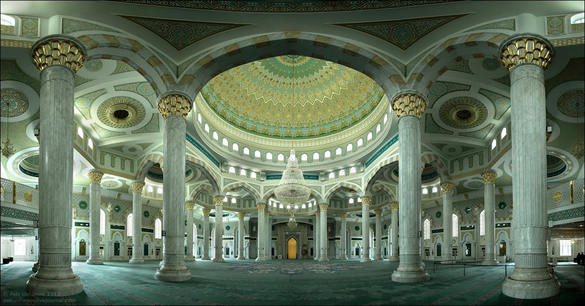
ASTANA (pop 776,000 / elev 350m)
The country’s capital has risen fast and is a showpiece for 21st century Kazakhstan. The skyline has grown more fantastical over the years as landmark buildings, many of them by leading international architects, sprouts in a variety of Asian, Western, Soviet and wacky futuristic shapes. It is easy to be impressed by the very concept of the place.
The city began its life in 1831 as a Russian fortress. Astana was a medium-sized provincial city known for its bitter winters, when President Nazarbaev named it out of the blue in 1994, as Kazakhstan’s future capital. Astana is Kazakh for ‘capital’. Reasons cited by Nazarbaev for the change were its central and less earthquake-prone location and better transport links with Russia.
The old centre north of the Ishim (Yesil) River remains the commercial and services centre. South of the river, a bevy of government, business, cultural, sports, and leisure buildings, shopping centres, hotels, a university and residential developments have resulted in it being dubbed ‘Dubai of the steppe’. It’s easy to question the spending of billions on prestige architecture, but most citizens are clearly proud of their new capital.
OLD CITY. Nothing much looks very old except for the shabby Soviet-style apartments. I stayed here at the Apple Hostel, impossible to find from the incorrect map in the LP (it is one block south of the marked spot across Imanov Street). All the dorm rooms were occupied by long-term residents and the four tourists were in bunks in the front ‘living room’, but it is cheap (2500T), clean and the company pleasant. I only stayed one night in Astana and was able to see all the sites in one afternoon and a short morning.
Museum of the First President. Housed in the former presidential palace, it is a succession of galleries and halls decked out with gifts to President Nazarbayev from foreign governments and grateful citizens.
Presidential Cultural Center. Closed for renovations, it is supposedly an excellent museum with Scythian gold and other burial treasures, models of Astana buildings, traditional Kazakh items, and Kazakhstan from the 15th to the 20th centuries.
NEW CITY. All the fantastic architecture is laid out on a perfect East-West Grid reminiscent of the Mall in Washington DC but with elaborate gardens instead of water features. From west to east are:
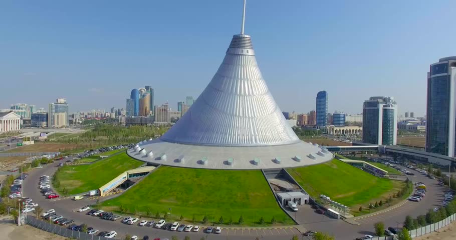
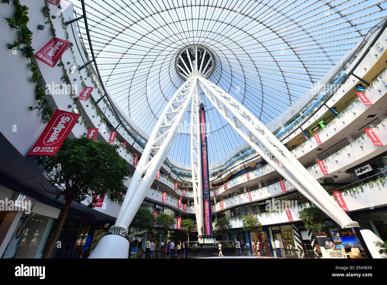
Khan Satyr. This 150m tall, translucent, tent-like structure contains a 5-story shopping mall including a beach club with sand imported from the Maldives (requires a 1500T “excursion fee” to see it). It was designed by Norman Foster.
Nur Astana Mosque. Just to the south of Khan Satyr, this four-minaret mosque was opened in 2005. The prayer hall is an exquisite multi-domed space with inscriptions and geometric designs in blue, white, gold and red.
KazMunayGaz. The headquarters of the state energy company, a large opening frames Khan Satyr.
Nurzhol Bulvar is a 2km long line of gardens and parks leading to the presidential palace. It is flanked by a sequence of large and imaginative buildings.

The Northern Lights are 3 light-green apartment towers with wavy sides.
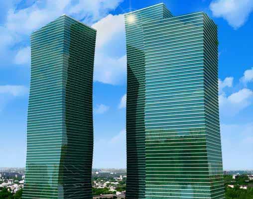
Opposite are the Emerald Towers, office blocks whose tops spay outward like the pages of books.
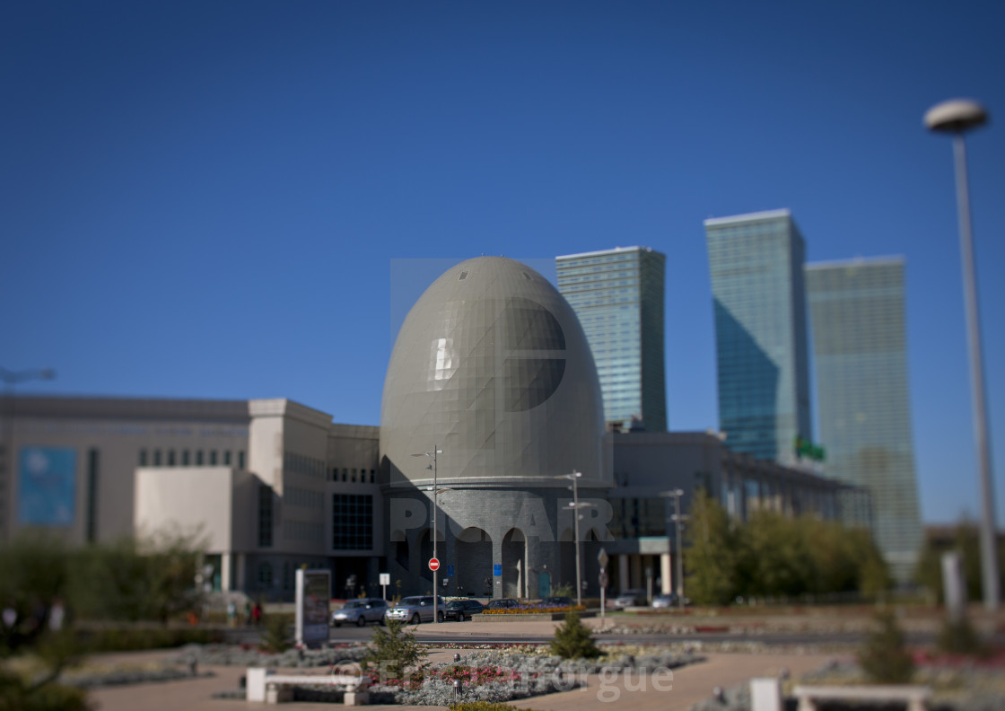
The Transport and Communication Ministry looks like a “lighter and the National Archive is an egg-shaped dome.
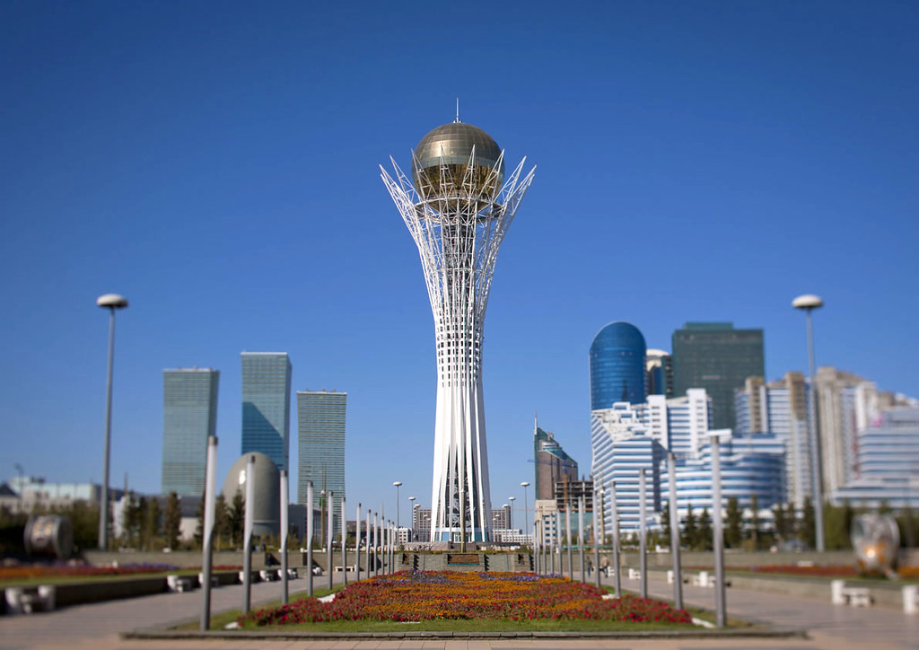
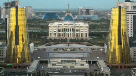
Bayterek Monument. The centrepiece of Nurzhol Bulvar is this 97m high white latticed tower crowned by a large glass orb. Views are superb from the top. A gold imprint of Nazarbaev’s hand serves as a wishing spot.
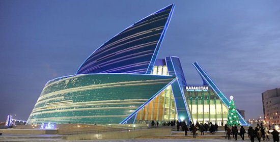
Nurzhol Bulvar on the east side of Bayterek Monument is flanked by the two wings of the House of Ministries and twin golden-green conical business centres. The two towers of parliament, the Senate and Mazhills, rise behind the northern ministerial building. A turquoise-tiled Central Concert Hall evokes the petals of a flower.
Ak Orda. At the end of Nurzhol Bulvar, is the huge white-pillared presidential palace built into a jut in the river and surrounded by a park. Across the river, the buildings continue in the same west-to-east grid.
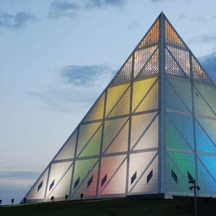
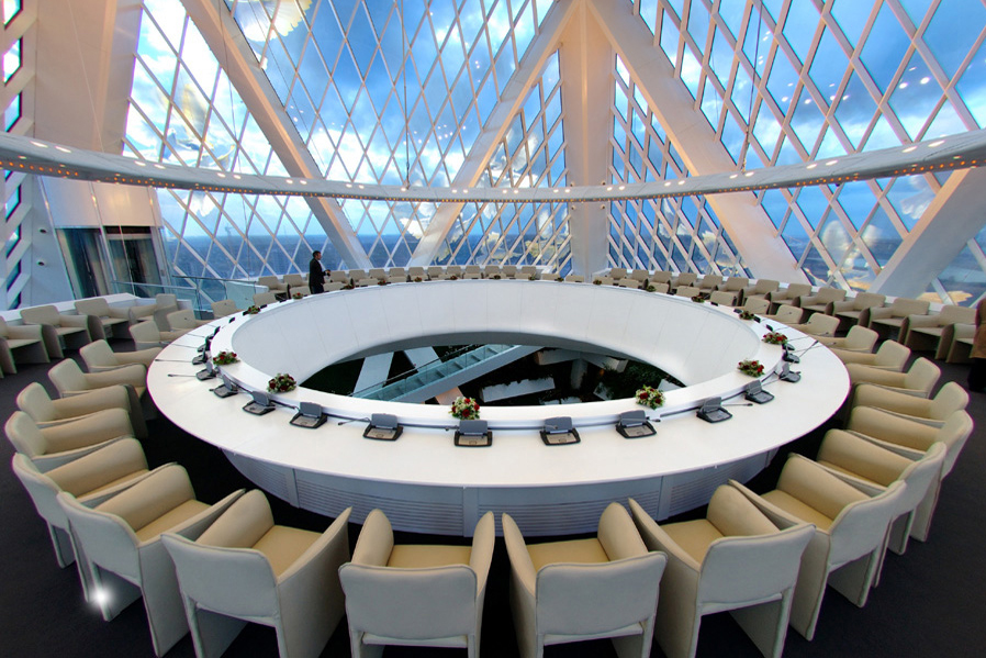
Palace of Peace and Accord. This striking, glass and steel pyramid contains a 1304-seat opera hall, a huge 3rd-floor atrium (for meetings and weddings, it rents for $370/hour), and a conference room at the apex with windows filled with stain-glass doves. This is home to the biennial Congress of World and Traditional Religions. It was also designed by Norman Foster.
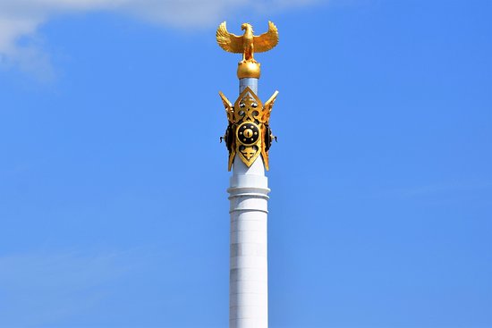
Kazak Yeti Monument. A 91m tall column topped by a golden Samruk.
Palace of Independence. Contains a huge scale model of how Astana is planned to look in 2030 and an ethnographic hall.
Shabyt. This is a huge concave ring of blue glass that holds an arts university.
Hazrat Sultan Mosque. Opened in 2012, this monstrous mosque has the largest dome in the country and is intricately decorated in the inside.
After seeing all these, we returned to walk the length again at night. Apartments to the sides of Nurzhol Bulvar, the Bayterek Tower and all the bridges are lit with ornate patterns of LEDs. Cranes dot the skyline as more is being constructed all the time.
KARAGANDA (pop 460,000)
220km south of Astana, I stayed here one night on my way to SW Kazakhstan. It was a good break on a 24-hour train ride. The through trains from Astana to Shymkent left either very early in the AM or very late and night and I would prefer to see as much country during the day as possible. It is very cold – well below zero with wind chill.
Karaganda is famous for two things: coal and labour camps. The two are intimately connected, as the vast ‘Karlag’ network of Stalin-era camps around Karaganda was set up to provide food and labour for the mines. Prison labour also built up much of Karaganda itself. During the depressed 1990s many of Karaganda’s ethnic-German residents (descendants of Stalin-era deportees) emigrated to Germany. The central area has plenty of parks and broad, tree-lined streets, mosques and orthodox churches.
Karaganda Ecological Museum. This is an imaginative museum with large rocket parts fallen on the steppe after Baykonur space launches and many hands-on displays.
Karaganda Oblast Museum. On the local history, it has a section on Karlag but there is no English.
From Karaganda, I caught a 19-hour overnight train to Shymkent arriving at 7 am. In my 4 bed compartment were 2 men and a woman, none of whom spoke any English. The compartment was hot and stuffy but I was finally able to get the car steward to turn down the heat and open the window.
SHYMKENT (pop 620,0000)
History. The Mongols razed a minor Silk Road stop here and the Kokand khanate built a frontier fort in the 19th century. Russia took it in 1864 and the whole place was rebuilt in Soviet times. Today it is a thriving trade and manufacturing (cement, cigarettes, oil refining) centre.
It is only 100km from Uzbekistan’s capital Tashkent. Its population is about 65% Kazakh and about 14% Uzbek.
As a tourist city, it has little to offer and serves primarily as a gateway to Turkistan. I walked all over and visited the Central Bazaar, Wedding Palace and Independence Monument (the tall Altyn Shanyrak monument represents the central roof opening of a yurt).
SAYRAM. About 14km east of Shymkent, Sayram was a Silk Road stop long before Shymkent existed and dates back possibly 3000 years. Kozha Akhmed Yasaui was born here and I followed the walking route to visit several sites – Kydyra Minaret, Karashash-Ana Mausoleum (Akhmed Yasaui’s mother buried here), Friday Mosque (it was Friday and in this predominately Muslim town, the Mosque was busy), and the Mirali Bobo Mausoleum (10th-century Islamic scholar) but after the directions bore no resemblance to where we were, it was raining hard, and after eating some delicious samsas, left town. The whole place is quite underwhelming, and I would only bother if I had nothing else to do.
We got here by hitchhiking as it was impossible to figure out the public transport (I had tried the previous day) and caught two buses back to Shymkent getting off about 1km south of our hotel.
Aksu-Zhabagly Nature Reserve. About 70kms east of Shymkent, this is where the mountain meets the steppe and has green valleys, rivers, snow-capped peaks and glaciers, and is part of the Western Tien-Shan Mountains, a WHS. Supposedly the most easily visited of Kazakhstan’s nature reserves, it was difficult to arrange a trip as the few tour operators responded. It is also very expensive with 2000T per day fees, 2000T per day ranger fee and besides horses, difficult to get around.
TURKISTAN
165 km northwest of Shymkent, this is Kazakhstan’s greatest architectural monument and most important pilgrimage site. It was a 2½ hour bus ride from Shymkent and I decided to stay overnight instead of going on a day trip. I went with a Dutch couple that I met in the hotel in Shymkent and we then met a German couple in the hotel. We visited the Mausoleum, Sauran and ate several meals together for a very enjoyable time.
Yasaui Mausoleum.
Kozha Akhmed Yasaui was born at Sayram in 1103, underwent ascetic Sufi training in Bukhara, Uzbekistan and then lived the rest of his life in Turkistan, dying here in 1167. He was a revered Sufi teacher and mystical poet who founded the Yasauia Sufi order. He communicated in Turkic vernacular making him very popular with the ordinary people. His book ‘Hikmat’ tells the basis of the Islamic world-view and narrates the moral decline of society appealing to kindness, and modest contentment, and condemning duplicity, greed and lies. Its poems advocated an acetic life and the moral and spiritual perfection of the individual. It was distributed throughout the entire Turkic world – Central Asia, Asia Minor, Azerbaijan and the Volga region.
His original tomb was a place of pilgrimage before Amir Timur (1370-1405) ordered a grand mausoleum built here. It took 15 years to construct and is now a Unesco World Heritage Site. Of all the mammoth works carried out by Timur in Central Asia, all the rest are in ruins and only this is preserved in its entirety. In plan and design, there is no equal in Central Asia.
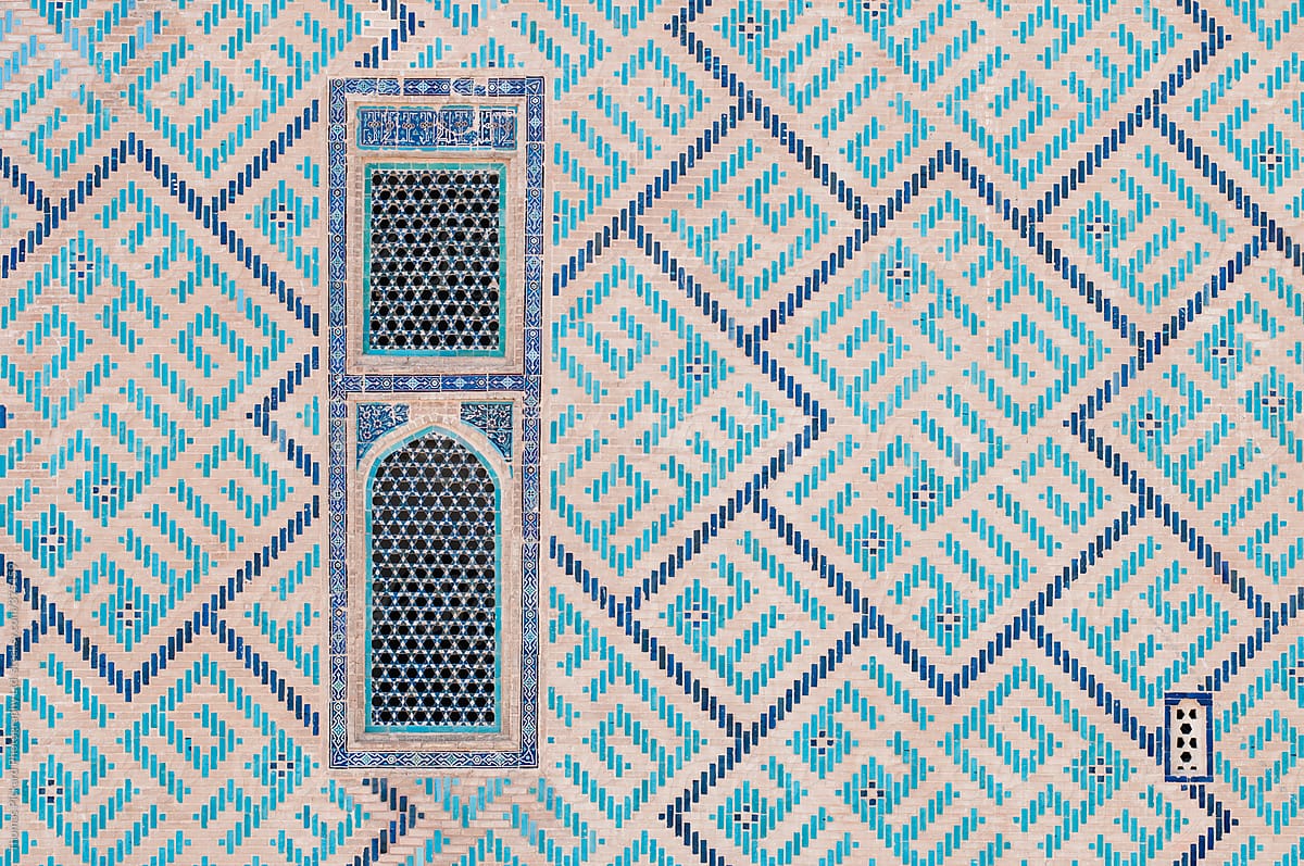
It is a grand 39m high building large enough to be seen from 10 km away. Timur died before it was completed and the main façade was left unfinished – today the front of the building remains bare of the beautiful tile work that adorns the rest of the edifice. Scaffolding poles still protrude inside the arched front. But the entire sides, back and two domes are covered in marvellous turquoise, white and multi-coloured tile in intricate geometric designs. The fluted dome above Yasaui’s tomb chamber is particularly lovely. It is difficult to believe that it is over 700 years old. According to legend, the bricks and tiles were made in Sayran, 40kms to the NW.

Inside, the main chamber (called the cauldron hall) is capped with an 18m-wide dome decorated in miquaina – a vaulted ceiling of honeycombed arches. Directly under the dome is a vast, metal cauldron (1.58m high, 2.43m wide, 2000kg weight with a 300 litre capacity) for holy water, given by Timur.

The lower portion of the walls are covered in green tiles and a stone belt decorated with fruit motifs circles the walls’ lower edge. Around this central hall are 34 smaller rooms including a carpeted mosque with a beautifully tiled Mihrab (Mecca facing niche). Yasaui’s tomb lies behind an ornate 14th-century wooden door at the end of the hall; you can view it through grilles from corridors on either side. The tomb of Abylay Khan, the leader of the Kazakh resistance to the Zhungars in the 18th century is also inside.
Outside the main building are small underground mausoleums for the rulers and elite. Another large, beautiful mausoleum in front of the main façade contains the wife of Sultan Begim who died in 1485.
SAURAN. 45 km northwest of Turkistan, this is the best-preserved and most atmospheric ruins of all the many ruined Silk Road cities in the Syr-Darya Valley. Sauran was the capital of the Mongol White Horde in the 14th century. It was described as a pleasant and cheerful city with two high minarets and a sophisticated water supply system. All that remains now are the remnants of the outside mud brick walls, mostly melting away from centuries of exposure to the elements. Beautifully coloured pottery shards litter the ground. There are remnants of a stone road and some minimalist archaeological digs in the centre but no structures remain. We walked the entire circumference. The place is entirely unsupervised and we were the only ones there.
I then caught a bus from Turkistan back to Shymkent, then another minibus to Tarez, 4 hours east. I then waited almost 4 hours until 11 pm to leave in another minibus for the 5-hour ride returning to Bishkek, Kyrgyzstan. We arrived at the border at 2 am. The Kazakhstan border was funny. There is a big “Good Luck” sign at each passport control desk. The fellow asked me “Is it cold in Canada?”, “Do you play hockey?”, “Where is your wife?” When I answered I didn’t have one, he asked “Why?”. I’ve never had a border guard ask a question before.
