
Tibet – September 13-21
The “roof of the world” promises breathtaking high-altitude scenery, awe-inspiring monasteries, epic road trips and a unique Himalayan culture that remains vibrant after a half-century of assault and repression. The color, humour and religious devotion of the immensely likeable Tibetan people is as much a highlight as the big sites. Tibet is changing fast as the Han Chinese bring ambitious construction and transport projects. The political tensions of recent years have resulted in strict travel restrictions on foreigners throughout the autonomous region.
I had many trials and tribulations arranging a tour. It was arranged through Snowlion Tours from Lhasa and I found them excellent to deal with. First it was not possible until late June to find which tours had a group (as a single, it is far too expensive to travel here alone). The initial dates were September 5-13, I planned my entire itinerary and then China closed Tibet to foreigners for all of September. Then they opened it except for September 5-13 to commemorate the 50th anniversary of the creation of the Autonomous Region of Tibet. Snowlion created a new tour for Sept 13-21 and I had to rework my itinerary significantly.
So on September 11, I left Urumqi, Xiajiang Province for a numbing 2½ days of buses and trains to get there: a 5-hour high-speed train to Liuyuan, a 3 hour minibus to Dunhuang to overnight, a 9 hour bus to Golmud and then a 14 hour train to Lhasa. On the bus to Golmud, I sat next to a wonderful young man from Gualin who spoke good English. He was traveling with 3 friends on their first visit to Tibet. I had dinner with them in Golmud and then shared the hotel room they had gotten to spend the 8 hours until our trains left. Very nice. From ours several hours of discussion, I came to understand the prominent role family plays in Chinese life.
The 4-lane divided highway, complete with overpasses for every small road was virtually empty. We passed through spectacular stark terrain. Just after Dunhuang, the snow-capped mountains framed the high sand dunes and foothills. After the initial mountains, it was a gravel desert flanked by brown, barren mountains. Near Golmud the road passes by Qarhan Salt Lake. The Ten Thousand Zhang Salt Bridge is 32 kilometres (20 miles) long crossing the whole lake. In fact, it is a section of Qinghai-Tibet Railway connecting Golmud and Dunhuang and part of Qinghai-Tibet Highway, wholly made of salt crystals. The salt surface is 15-18m (49-59ft) in depth, hard enough to take the load of the railway/highway. The ‘bridge’ is like a jade belt passing through the lake, surprising people with its beautiful surroundings and extraordinary construction, without guardrails or piers. It is a must-see scenic spot upon arrival.
I boarded the train at 02:30 and climbed into my hard sleeper for a well-deserved sleep.
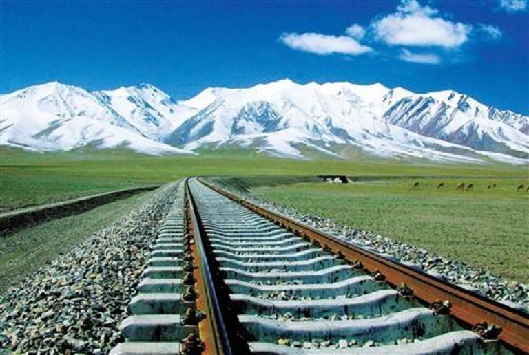
The Qinghai-Tibet Railway is the world’s highest train ride, topping the 5072m Tanggu-la Pass. 80% of the Golmud to Lhasa stretch is above 4000m. An impressive piece of engineering, there are 160kms of bridges and elevated track built over permafrost, so sections of cooling pipes were inserted to help keep the boggy ground frozen in summer. It cost US$4.1 billion and a section to Shigatse is under construction.
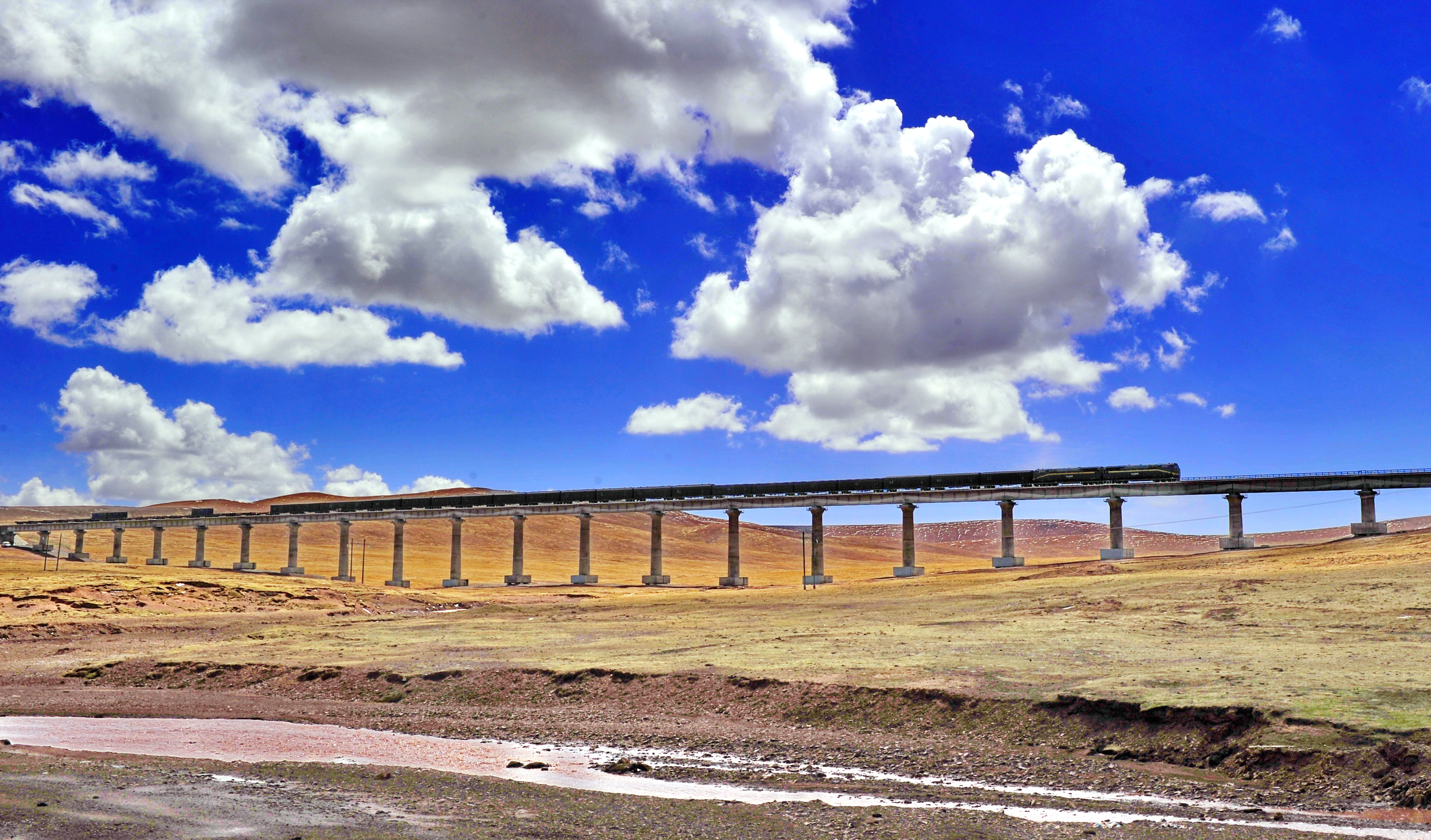
The Chinese are rightfully proud while many Tibetans aren’t quite so sure. It brings cheaper Chinese-made goods and greater economic growth but also delivers one million passengers to Lhasa every year. It staples Tibet ever more firmly to the rest of China.
A foreign traveler needs a copy of their Tibetan Tourism Bureau Permit (I had to produce it several times: at the entrance to the train station, at the entrance to the platform, on entering the train, in the train and to the police in Lhasa). There was snow on the ground at Tanggu-la Pass. The landscape is vast with wide grass-covered plains framed by low mountains. Small braided rivers, herds of yaks and sheep, isolated flat-roofed houses and occasional herders punctuated the landscape. Small towns increased as we neared Lhasa and mountains closed in as we followed a fast-flowing river. The wheat harvest with the same labour intensive methods was nearing completion (although I did see a tiny combine).
HOH XIL is an isolated region in the northwestern part of the Qinghai-Tibet Plateau in Qinghai province, China. In 2017, it was listed among the World Heritage Sites as “the largest and highest plateau in the world”.
The region covers 83,000 square kilometres at an average elevation of 4,800 metres above sea level. Hoh Xil is volcanic.
Despite the harsh climate, Hoh Xil is home to more than 230 species of wild animals, 20 of which are under Chinese state protection, including the wild yak, wild donkey, white-lip deer, brown bear and the endangered Tibetan antelope or chiru. The abundant plateau pika, a small burrowing rodent, is the main food of the region’s brown bears; the bears also feed on the yak and antelope.
The Qingzang Railway and China National Highway 109 run along the eastern boundary of the reserve. The Fenghuoshan Tunnel, presently the world’s highest railway tunnel (1338 m long, with entrances located at an elevation of 4905 metres above sea level), was constructed in the area
LHASA (pop 400,000, elevation 3650m)
I was met at the train station by our driver, guide and the rest of the group that had just arrived from Chengdu by plane. Dolkar, our guide, is 31, Tingri and from the Shigatse area. She was a great guide with a wealth of information. Tibetans cannot have passports and I asked Dolkar if she would leave for India if she could get a passport? Primarily because of family, she wouldn’t. But life in Tibet under Chinese control is quite good, and much better than in India. Restrictions on Tibetans, though not as radical, is similar to the controls North Korea places on its citizens. The Great China Firewall attempts to control access of Chinese to the ideas of the west.
Lhasa is the traditional, political and spiritual centre of the Tibetan world. Despite the rampant Chinese-led modernization, Tibet’s premodern and sacred heritage survives in the Potala Palace and ancient monasteries. Lhasa is a comfortable traveller’s destination with dozens of budget hotels and excellent inexpensive restaurants. Lhasa is also the only current place in Tibet where one can have a certain freedom to explore without your guide, plus it’s cheaper as you don’t need to hire transport.
Lhasa divides into a sprawling Chinese section to the west and a much smaller, but infinitely more interesting Tibetan old town to the east centred on the wonderful Barkhor area. Ignore the constant security checks, military patrols and riot squads.
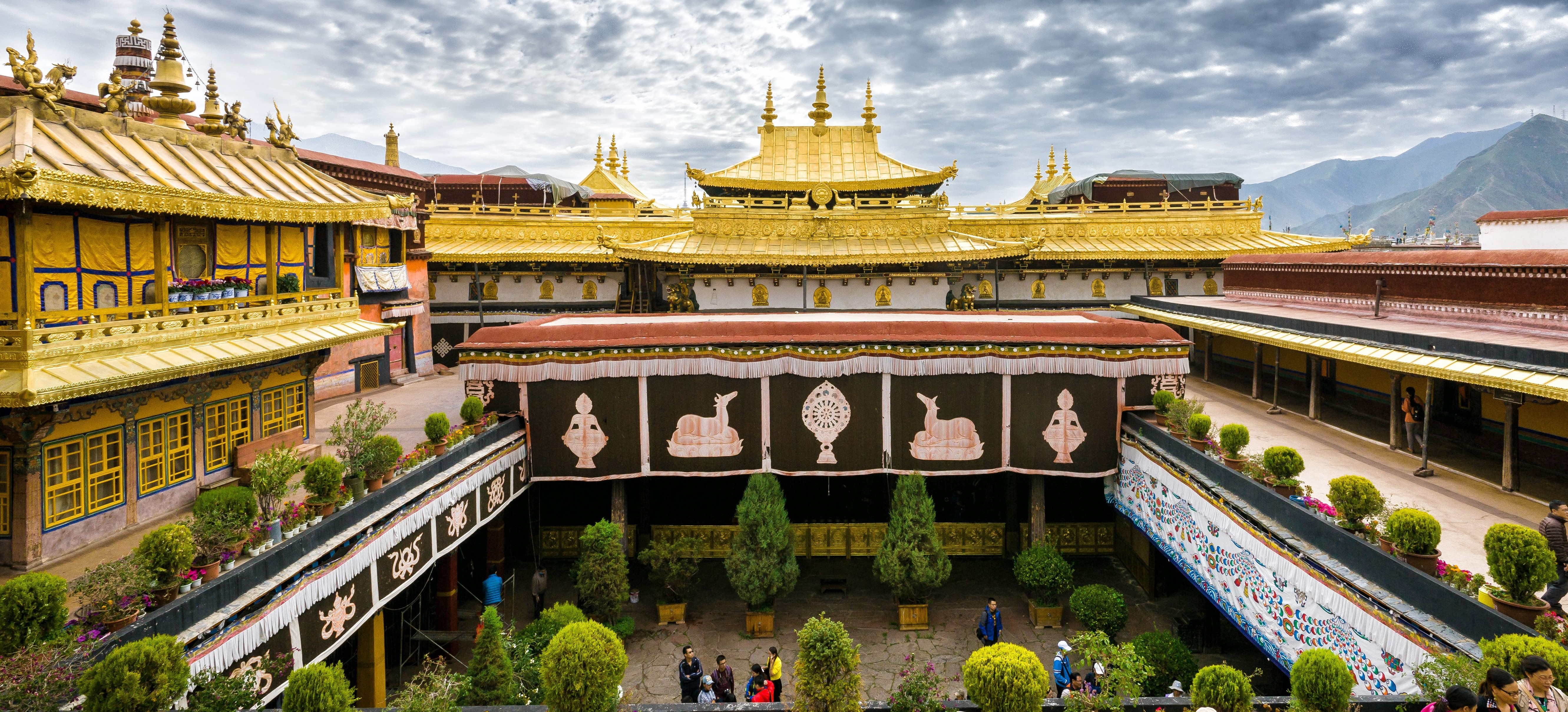
Barkhor. It’s difficult not be swept up in the tide of humanity that is Barkhor, a kora or pilgrim circuit that winds clockwise around the Jokhang Temple. The crowd of pilgrims is captivating – they come from all over Tibet. White ovens bellow the smoke of incense burning. The most impressive were two men prostrating themselves every few meters – wood and metal sliders on their hands.

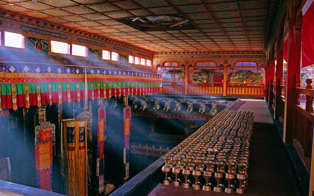
Jokhang Temple (85¥). This 1300-year-old, Unesco-rated temple is the spiritual heart of Tibet with the continuous movement of pilgrims prostrating themselves outside. The golden roof-lines foretell the ancient interior with frescoed walls and carved pillars. The central golden Buddha here is the most revered in all of Tibet. Climb onto the roof for more views.

Potala Palace (200¥). Once the seat of the Tibetan government and the winter residence of the Dalai Lama, it is Lhasa’s cardinal landmark. The first site of the towering maroon, yellow and white fortress-like walls will be remembered for a long time. An architectural wonder even by modern standard, the palace rises 13 stories from the top of a 130m-high mountain and contains more than 1000 rooms.

The first recorded use of the site dates from the 7th century when a palace was built here. Construction of the present structure began during the reign of the 5th Dalai Lama in 1645 and took more than 50 years to complete. Zhou Enlai sent his own troops to protect it from the Red Guards during the Cultural Revolution.
The layout includes the rooftop White Palace used for government and the residence of the Dalai Lama, and the central Red Palace used for religious functions. The most stunning chapels house the jewel-bedecked golden chorten tombs of previous Dalai Lamas. The apartments of the 13th and 14th Dalai Lamas in the White Palace offer a more personal insight into life in the palace. Grand aesthetics and history aside, one can’t help noticing that today it is essentially an empty shell, notably missing its main occupant, the Dalai Lama.
Tickets are limited. The day before you visit, your guide will take your passport and reserve a time slot for your visit the next day. Visit the excellent museum of treasures first and then climb the stairs to the palace. Photography is not allowed inside. Exit on the north side down long stone walkways above the lake.
Before we went into the Potala Palace, we had some time to wander around. I parked myself on a bench on the kora that goes around the palace. This may be the best people watching in the world as pilgrims from all over Tibet come here. Prayer beads are in the left hand and a prayer wheel twirling in the right. Most are older and many are truly ancient but spry for their apparent age. Their skin was dark and leathery. But others are stooped with slow shuffling gaits, limps, using canes or crutches and their determination to walk the kora is impressive. Traditional dress varies but is most often a long skirt with a colorful stripped apron and multiple necklaces’ of turquoise, amber, coral, glass and wood. Some push baby strollers.
All the window frames are rhomboid in shape, narrower at the top. This is identical to Inca door and window frames, built this way to deal with earthquakes.
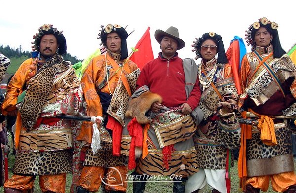
There are many separate ethnic groups in Tibet. One that was particularly striking were the Kham – tall, broad-shouldered with identical “cowboy” hats and long braided hair in both sexes. From Eastern Tibet, they don’t farm but are businessmen selling jewelry, caterpillars, and Buddha images. Their personalities are aggressive and other Tibetans generally don’t like them. The men often will have a wife at home and a mistress in Lhasa and often are in groups on the Barkhor doing business. The women were a simple brown skirt, tight-fitting blouses, no necklaces and elaborate coral and gold earrings looped around the entire ear. At one time they served as body-guards for the Dalai Lama.

Another group are the Nachu who wear their hair braided and plaited with coloured yarn wrapped around their head. Dolkar, our lovely guide is Tingri, an ethnic group from the Shigatse area. They have prominent rosy-red cheeks.
Drepung Monastery (30¥). 8km west of the old town, it was purportedly the largest monastery in the world with around 7000 resident monks at its peak. The kings of Tsang and the Mongols visited regularly, though oddly, the Red Guards pretty much left it alone. Around 600 monks reside here now.

Sera Monastery (60¥). 5kms north of central Lhasa, it was founded in 1439, and along with Drepung, was one of the treat Gelugpa (Yellow Hat) monasteries. 600 monks, down from 5000, reside here. The spectacular prayer halls had ornate carving and metal work backing up the many Buddha images. In the afternoons, you can see Tibetan-style religious debating with lots of hand slapping and gesticulating.
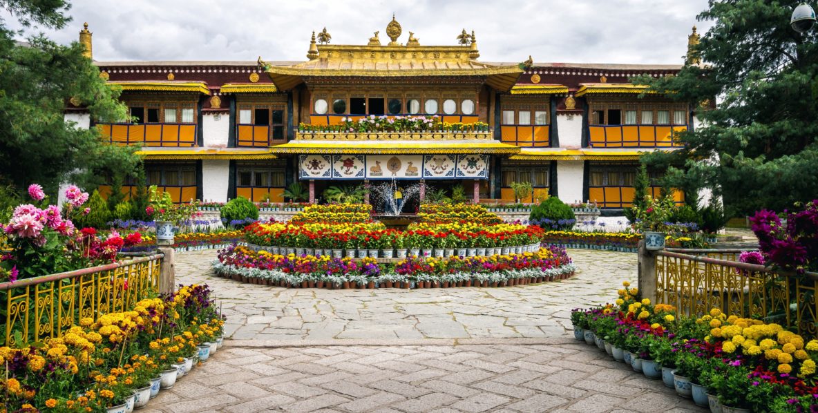
Norbulingka. It served as the traditional summer residence of the successive Dalai Lamas from the 1780s up until the 14th Dalai Lama’s exile in 1959. Part of the “Historic Ensemble of the Potala Palace”, Norbulingka is recognized as a UNESCO World Heritage Site, and was added as an extension of this Historic Ensemble in 2001. It was built by the 7th Dalai Lama and served both as administrative centre and religious centre. It is a unique representation of Tibetan palace architecture.
Norbulingka Palace is situated in the west side of Lhasa, a short distance to the southwest of Potala Palace. Norbulingka covers an area of around 36 hectares (89 acres) and considered to be the largest man made garden in Tibet.
 I spent two lovely evenings with a young Chinese woman I had initially met in Dunhuang. Unusually for a Chinese woman, she was traveling alone. They all lie to their helicopter-parent mothers: they tell them they are traveling with friends and never mention Xinjiang nor Tibet, both viewed as dangerous places. I believe we will travel together sometime in the future. Otherwise time is spent with our guide and the three American from South Carolina in my group. Bruce is my age and it would be difficult to find someone with more similar political views and travel interests. It is information overload in all these tourist sites.
Monument to the Peaceful Liberation of Tibet

FRIENDSHIP HIGHWAY
This 865km route from Kathmandu to Lhasa offers one of the great overland routes leading to some of the most magical destinations on the plateau. Since the Nepal earthquake of April 2015, the Friendship Highway is closed at Chinese Immigration next to the Nepali border. The route from Lhasa to Shigatse is a side route of the actual highway, the one most travellers take, and the one with the most attractions.
We left Lhasa early to drive 350km to Shigatse. We initially followed the Brahmaputra River that flows 2500kms SE into India.
The people here practice natural burial systems: either chopping up and putting the bodies in the river or sky burials where the bodies are eaten by birds. The bones are then collected, cremated and the ashes put in the river.
Flocks of black-faced sheep shared the highway. Spray paint designated ownership and cloth markers showed sheep that could not be slaughtered. As we climbed up into the mountains, we stopped at a viewpoint with knickknack stands and a local dog, a type of mastiff. They are big with heavy jowls, wrinkled faces, and thick red-brown coats with their neck fur combed out like a lion’s mane. Their only work is for tourists – photo-ops cost 10¥.
Once we reached Kamba-la Pass (4794m), we stopped at a viewpoint high above Yamdok Lake, one of three holy lakes in Tibet. At 638 sq. km (the size of Singapore) and long and narrow, it is a nice turquoise indicating its glacial origin (not as deep a colour as the lakes in the Canadian Rockies). Far in the distance to the northwest is the huge massif of Mt Nojin Kangstang (7191m).

After descending to the lake, we went over 5,020m Karola Pass with spectacular glaciers. The locals charge 50¥ to take a photo.

Today I purchased two souvenirs: a gorgeous beaten brass ringing bowl with great tone and a huge chunk of turquoise. Passing through nice mountains, the terraces along the river grew mustard and barley. The harvest was just starting. The last hundred kms was in a broad valley filled with wall-to-wall barley fields filled with small haystacks.
SHIGATSE (pop 80,00, elevation 3850m). This is the second largest city in Tibet and has Tibetan and Chinese sections. As the traditional capital of the central Tsang region, it was long a rival for political control of the country. The Tsang kings and subsequent governors exercised their control from the imposing heights of the Shigatse Dzong. Since the time of the Mongol sponsorship of the Gelugpa (Yellow Hat) order, Shigatse has been the seat to the Panchen Lama, the second highest ranking lamas in Tibet. One could view the Dalai Lama, stationed in Lhasa, as the political leader and the Panchen Lama as the religious (and more scholarly) leader.
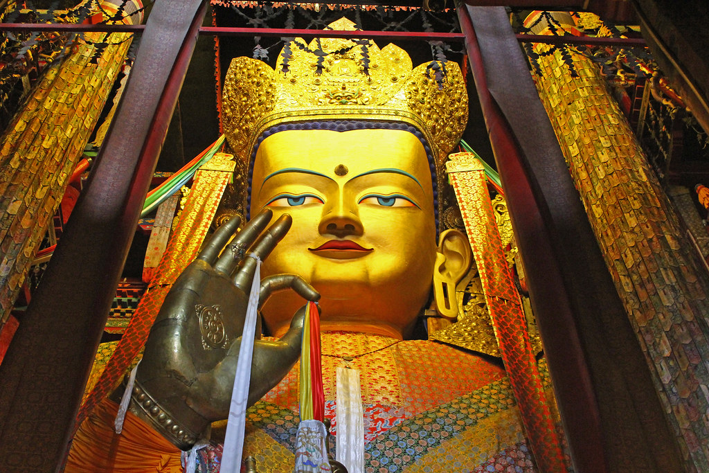
Tashilhungo Monastery (85¥). This is the seat of the Panchen Lama and one of the six great Gelugpa monasteries (along with Drepung, Sera and Ganden monasteries in Lhasa, Kumbum in Qinghai Province, and Labrang in Gansu). Built in 1447, the monastery is the size of a small village. It is divided into four main chapels. Filming is expensive here: using a camera is 125RMB.

The Temple of Maitreya contains the 27m statue of Jampa (Maitreya) Buddha, the largest copper-gilded Maitreya Buddha in the world.
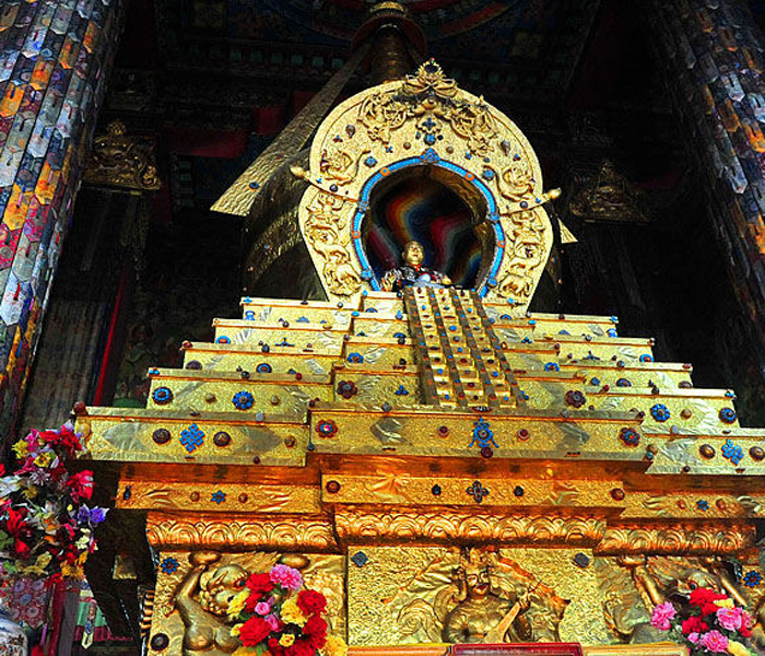
The other three chapels contain the chorten tombs of the 4th, 10th, and 5th to 9th Panchen Lamas). All opulent, they are silver and gold (the 10th’s is covered in 500kg of gold) structures encrusted with jewels. The metal work is outstanding with the four directional gods on the sides. A simple turquoise, glass and precious stone swastika is embedded in the floor outside one of the chapels.
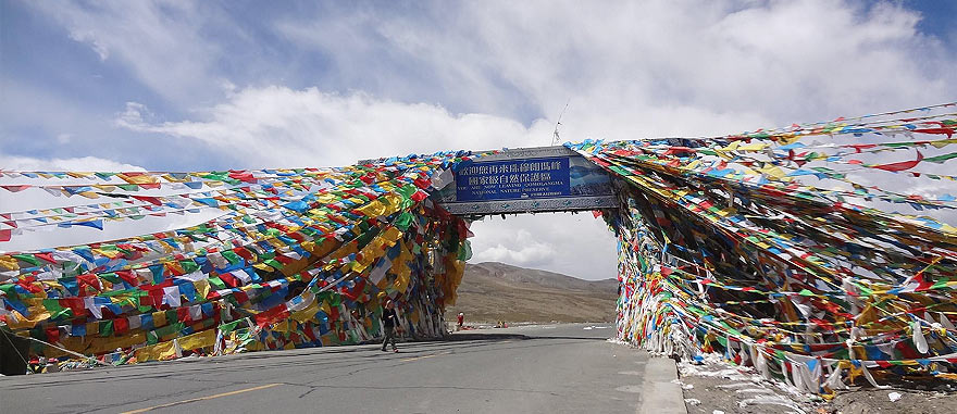
Continuing on from Shigatse, we drove the actual Friendship Highway, loaded with speed traps and inexplicable 30km speed zones. We drove over the high point of the trip at 5248m Gyagso-la Pass, a bleak landscape, but with thousands of prayer flags. It was warm with snow visible only on a few high peaks in the distance. The Himalayas are visible in the far distance only on very clear days.
Sakya. In the 14th century, this monastic town, with the help of Mongol military support, became the short-lived rulers of all Tibet. The main monastery, built in 1298, is a massive fortress-like compound, with high defensive walls. The serene assembly hall is easily the most impressive of any we have seen: multiple Buddha images and tomb chortens displaying marvellous metal work. The hall also contains one of Tibet’s great libraries, with Buddhist manuscripts everywhere.


Shagar. Most people stay here for their last sleep before heading to Everest Base Camp, about 100kms south. Above the town is a monastery/fort with a defensive wall climbing the virtually vertical ridge. After walking to the monastery and snooping around, we climbed up to the wall with its crumbling battlements and red guard towers. Unfortunately most of the wall had been destroyed in the Cultural Revolution.

The town’s monastery is surrounded by impossibly steep walls ascending the small peak behind. Unfortunately most of the walls were destroyed during the Cultural Revolution.
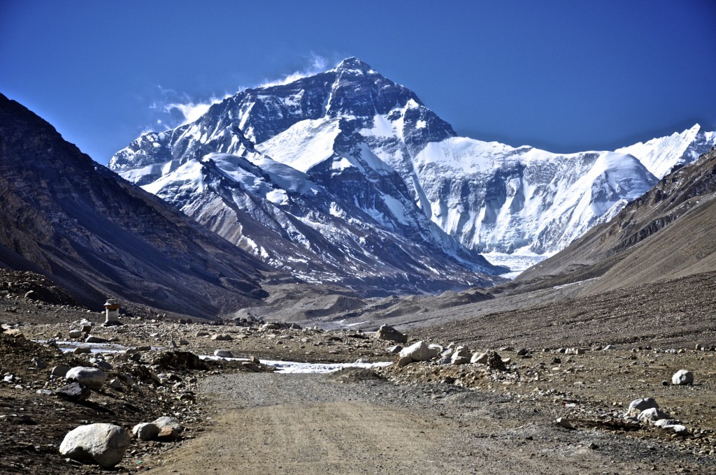
From Shagar, it was not far along the Friendship Highway before we turned south on the highway towards Everest. It was only paved one year ago and is dramatic – 42 switchbacks up to Go-la Pass at 5198m and the first views of an enormous swath of the Himalaya. We were very lucky with picture-perfect views and clear skies.
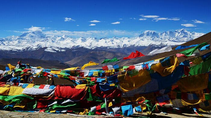
Within 20kms of Everest are 5 mountains above 8000m and 40 above 7000m. From the pass, the visible mountains from east to west were: Makalu #5 – 8463m, Nutseri (a perfect cone) – 7884, Lotse #4 – 8516m, Qomolangma (Everest) #1 – 8554m, Gomoluntso – 7581m, Chantseri – 7543m, Pumori – 7145m, Gomoluntso – 7581m, Gyachongkhan – 7994m, and Cho Oyu #10 – 8201m.
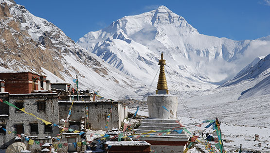
The road descended down a similar set of switchbacks to another valley floor with a village and barley fields waiting for harvest. We then followed the valley west and south up to Bongphu Monastery. This is the highest monastery in the world (5000m) and the first monastery in Tibet.
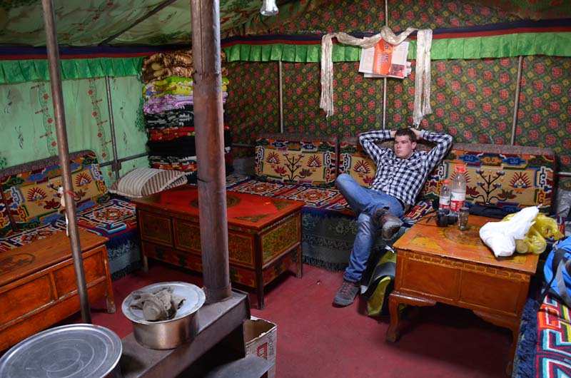
Soon after, we reached the tent hotel area. About 50 felt wall-tents are set in a rectangle. They are beautiful inside with carpet covered benches and beds set around a small stove and tables. The wood pellets burned in the stove turned out to be sheep dung laboriously collected around the hotel. Each tent has a separate cooking area in the back. A China Post kiosk is here (the highest post office in the world) but you could only buy books of 10 postcards that could only be mailed within China. We had a clear vista up a glacial valley to the sheer North Face of Everest.
Every tent has a knick-knack stand outside and lots of jewelry and stuff for sale. The turquoise and amber is all fake. One of the interesting things are ammonite and trilobite fossils. This area was once sea but most of the sedimentary rock is covered by huge amounts of gravel. The entire Tibetan Plateau was pushed up by the collision of the Indian subcontinent against Central Asia within the last 10 million years.
EVEREST BASE CAMP (5150m). From the “hotel” it is a 4km bus ride (25¥) to a parking area, a walk up a small hill festooned with prayer flags and a view down to the actual Base Camp with Everest in the background. The climbing season here is April and May when there is much less snow on this side of the mountain (it is now the end of monsoon in India and Nepal). Usually about 50 teams climb the mountain each year at a cost of US$25,000 per climber, but there has been none since the earthquake. The views of the North Face were sublime – completely covered in snow and no clouds. All views of Everest from China are far superior to anything you’ll see in Nepal (you can’t even see Everest from the Nepali Everest Base Camp). Everest is known locally as Chomolungma (often spelt Qomolangma) or Zhufeng in Chinese. There is a strong army presence here and we had two passport/permit checks on the way.
Sunset on the mountain could not have been better. Between 6 and 6:30pm (local time, not Beijing time which the entire country runs on), the light turned light yellow, then pinkish. Once all light was off the mountain, the entire sky turned pink. We could not have been more fortunate.
We then had two long days of driving with an overnight in Shigatse to return to Lhasa. Driving the entire way on the Friendship Highway, we had 5 military checkpoints. Supposedly to control speed, one cannot pass the next checkpoint until the allotted time is up. As a result, we had 10-20 minute waits before each checkpoint. I think it is much more about political control. Much of the drive followed the Brahmaputra River, some through a dramatic canyon.
I haven’t slept well since leaving Golmud on the train. A poor sleeper at the best of times, I have been waking up every hour or two and am unable to get back to sleep. Even though I have no altitude symptoms and am not breathless, I can only ascribe this to the altitude (for those metrically challenged, 5,100m is almost 17,000 feet).
On my last evening in Lhasa, when sitting people-watching on the square, a 29 year-old Tibetan woman sat down to talk. Two hours later, I had her life story, illustrative of Tibetan Life. Raised in a family of 5 children in a remote area near Mount Everest, she illegally left Tibet with her older brother and parents at age 6 to live in Nepal. They lived there for 8 years when her parents and brother returned to Tibet. She went to Dharamsala, India to live at a boarding school for 2 years to get her grade 10 and then returned to Tibet. Her eldest brother lived in Lhasa and suggested an arranged marriage so that she could obtain home registration in Lhasa (Without that she could not live in Lhasa year around). Now married for 8 years, she has a son and works in the travel industry. She is very bright and fluent in Tibetan, Nepali, Hindi, Mandarin and English (amazing as there are 4 different scripts). But she has no proof of her Nepali/Indian education, cannot take equivalency exams, and cannot further her education. She would love to travel (everyone wants to go to Switzerland), but of course cannot.
It was sad to say good-bye to Bruce. I enjoyed his company. He was continuing onto Nepal to trek and then maybe climbing Kilimanjaro. Hopefully we will meet again. But I will not miss the two women in our group. I am doing a slash and burn only to illustrate the difference between a traveller and a tourist. They were easily the least interesting people I have ever met – all they could talk about was shopping and their friends at home – one said bless you every time anyone sneezed or coughed (bless you derives from the Black Death when the first symptoms were sneezing – it just isn’t relevant to today and as an atheist, I find irritating). They showed no interest in anyone else and never said anything to me the whole trip except twice with a lot of negativity. True tourists, they will survive in India only because they are flying everywhere and have a car and driver. Everything is already reserved. They can’t manage their voluminous luggage on their own and could never deal with trains or buses. They gave candy to kids – giving anything to children is generally not acceptable as it only encourages begging and kids do not need sweets. Spending anytime on the streets will overwhelm them – beggars are everywhere and they will do nothing but have pictures taken with every Indian who sees them. Foreigners are treated like god in India. They understand nothing of Indian behaviour. Crossing an Indian street will be impossible. They are not travellers and will see a very sterilized India.
There were many reasons I went overland to Tibet rather than flying. The flight from Urumqi was $980 and involved a 15-hour layover in Chengdu. Overland I went through a lot of country and many trains and buses, basically taking 2 full days each way, but at about half the price. I saw the country from the ground – all the desert in North Xinjiang and Qinhai and then across the entire Tibetan plateau. It is marvellous hardscrabble mountains and grassy plains in Tibet. So much of Western China is not usable country. If flying, the hard-copy Tibetan Permits must be couriered to your hotel wherever you are in China (this can be very time limited), but if going overland, only printed copies are necessary.
I spent the 14-hour train from Lhasa to Golmud talking to Jeff, a 22-year-old Chinese guy with excellent English. We tried to sort out all the problems with his girlfriend. I taught him and his sweet father how to play Yavin, a great travellers card game. We had a great time eating and talking about life.
Also on the train in the hard seats, were many young army guys. They were playing a card game (best 2 cards dealt) and hundreds of dollars changed hands on each deal. Because of the great pressure in China to get a college education, most of the guys here were ones not able to pursue that. We arrived at 01:15.
In Golmud, I connected with a fellow from the train to share a hotel room until our onward travel at 9am. The first hotel (147¥) would not accept foreigners. The hotel that would was 280¥, so we slept in the train station. I bought the cheapest train ticket to somewhere for 16¥ to get into the train station. Security confiscated my shave cream, the first time that has happened in 12 weeks of travel in China, despite having always carried an aerosol can all that time and going through hundreds of security checks. When sleeping in a train station think bright lights, lots of noisy people, frequent loud announcements of train departures, cold, and a hard metal bench. But I did sleep in my cozy sleeping bag.
The bus for the 8-hour ride to Dunhuang (my third time here) was packed. I am glad I had gotten up at 7:30 to get my ticket. I immediately got a bus for the 3-hour ride to Liuyuan and had no problem getting a soft sleeper bed (soft sleepers have 4 bunks in a compartment with a door instead of 6 beds in an open compartment but the beds are no softer) for the 10+hour ride to Turpan overnight.
I have now had many great relationships with several young Chinese – Anna, Kiki in Urumqi, Sam in Golmud and then Jeff on this last train. Chinese are very friendly and always wanting to practice English and talk. They think just like us and have all our aspirations. But relations with girls are more complicated as to get married, one must have a career and an apartment. Supporting one’s parents is very important.
Chinese have now become the most frequent world tourists (usually two week tours). I can personally tell them apart from the other east Asian nationalities by facial features and dress. Because of their cultural issues and generally poor English, they are not generally well liked by Western tourists. However, I have had universally good experiences with all these college educated, intelligent, social, young Chinese.
