
CHINA – Aug 25- Sept 30 2015
I’m back in China to see the west of the country and travel the Silk Road from Xi’an to the Middle East. Having had such a great 2 months here last year, I have none of the anxieties I had then traveling in a country with no language and no knowledge of characters. But that is because it is so organized – most everything works.
Pleco Chinese Dictionary. Pleco is the ultimate Chinese learning companion – an integrated Chinese English dictionary / document reader / flashcard system with fullscreen handwriting input and live camera-based character lookups, from a company with 15 years’ experience making mobile Chinese learning. This is the ultimate translation app – it does everything.
Chinese Visa. I applied for a double-entry 60-day visa in Vancouver and got a multiple-entry eight-year visa that expires in 2023! Unfortunately, I won’t have this passport after this winter – ten-year passports only last 2-3 years for me. I also have no plans to return to China again.
When I was in Vancouver Airport at the food court, I heard loud chewing – it was coming from a Chinese guy sitting 3 tables away. I heard every chew of his foot-long sub. And it reminded me of how the lack of social awareness pervades Chinese society. Last year it irritated me, but I have decided not to let it get to me. After all, I am in their country and need to simply accept the horking and spitting, chewing with their mouth open, and lack of social awareness (see my post on cultural issues in China from last year). This is China.
It was an 11-hour flight from Vancouver to Shanghai on China Eastern. After a 3-hour layover, I had a 2-hour flight to Xi’an. My pack didn’t arrive with me; it came on a flight six hours later, and I just made the 17:00 bus for the four-hour ride west to Tianshui. The Silk Road wanders all over western China and the Stans before entering Iran and the Middle East. A visa to Iran is difficult for Canadians (and Americans and British), expires 3 months after issuing and travel in Iran requires a tour. I desperately wanted to go there, but I will now fly over it.
People over 60 and students pay half price, so always bring your passport and show it at all attractions.
“The Private Life of Chairman Mao”. I read this book when in China, and for anyone with even a remote interest in China it is a must-read. Written by his personal physician of 22-years, it is very insightful. He was uneducated, never brushed his teeth (rinsed only with tea and his teeth were covered in a green plaque) and never bathed (he was wiped down with moist, warm towels and his genitals were never washed), although he liked to swim. He kept very irregular hours and was addicted to sleeping pills. The vast majority of the time was spent in a bath robe as he did not like to get dressed. His most objectionable habit was his extreme sexual appetite. Nobody knows how many relationships he had, but they probably numbered in the thousands – all young, impressionable women who served as his nurses or were in entertainment troups. He had trichomonas vaginalis and herpes simplex but refused treatment and was a constant source of spread.
The Great Leap Forward (1956-61) was brought about by a desire to increase steel production in small local kilns. Most men got involved in melting down every bit of metal they could find (doorknobs, utensils, pots) into useless iron ingots, but were so obsessed that they forgot to bring in the harvest. Despite good weather and bountiful crops, millions died of starvation and disease. The next boondoggle, the Cultural Revolution was simply a ploy to consolidate his power and millions more died in the ensuing violence. He encouraged criticism by the right and then got rid of them all.
One of the interesting bits was his preservation after death. Vietnam (Ho Chi Minh) and Russia (Lenin and Stalin) provided no knowledge on how to do it and they had been slowly rotting for years. Their parts were replaced by wax. I have seen them all (including the two North Koreans. Stalin was eventually buried) and I believe they are all wax. It is impossible to preserve bodies with formaldehyde so that they last forever.
GANSU PROVINCE
Synonymous with the Silk Road, the slender province of Gansu flows east to west along the Hexi Corridor, the gap through which all trade passed from China to Central Asia. This left Buddhism, beacon towers, forts, chunks of the Great Wall and ancient trading towns in its wake.
Gansu has an enormously rich cultural and geographic diversity. The ethnic diversity is equally great: Linxia has a large community of Hui Muslims, and Xiahe has a pronounced Tibetan heritage. Other minority groups add to the colourful patchwork.
History. The first significant push west along the Hexi corridor came with the Han dynasty, and the Silk Road was born. They extended the Great Wall through the corridor. Trade grew, and way stations appeared that became the towns and cities of present-day China. Traders from the west and the east left their mark to produce the incredible diversity of modern Gansu. The many Buddhist grottos of Bingling Si, Maiji Shan, Mogao and elsewhere are a testament to the flourishing of religious and artistic schools along the Road.
The mixing of cultures led to serious tensions that culminated in the Muslim rebellions of 1867 and 1877, leaving millions dead and virtually wiping out Gansu’s Muslim population. There were pro-Tibetan demonstrations in 2008.
Gansu is not poor and has a GDP that has been growing at a higher rated than the already blistering national average. There have been massive investments in clean energy.
Climate. Gansu rarely sees rain outside of the southern regions, and dust storms are common. Winter is cold from November to March, and summer temperatures top 40° C.
Language. Gansu has its own regional Mandarin dialects, and Tibetan Amdo is spoken on the borders of Qinghai and Sichuan.
MAIJI SHAN. 35 miles SE of Tianshui is “Haystack Mountain,” whose cliffs are riddled with niches and statues carved from AD 389-581. On my quest to see everything Buddha in the world, I am glad I did not miss this one. The 221 caves and 1000 statues on the vertical cliff face are accessed by catwalks and stairways crossing the cliff. Most of the statues are made of clay with elaborate clothing and detailed painting. Six large statues, the biggest at 15.7m, adorn the cliff outside the caves. How all this was carved remains a mystery – it is thought that they worked on piles of wood blocks.
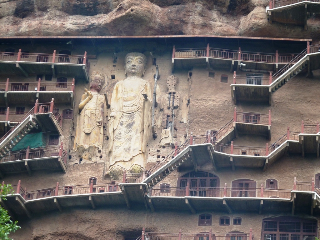
Getting to Maiji Shan was a test. On my quest for directions, I was given every point of the compass but eventually caught bus #1 to the train station in East Tianshui and then #34 to the grottos (cost $1.50!). These caves were heavily defaced by the Red Guards in the Cultural Revolution.
Returning to my hotel, I caught the bus 280 km west to Lanzhou. The low deforested hills were covered in terraces for most of the distance – quite amazing to see them go to the top of almost every mountain. It was very similar to Peru but much more extensive. Here the big crop is corn (no rice), potatoes, vegetables and apples. Most of the terraces had crops – every inch of land must be used in China.
LANZHOU (pop 2.17 million)
This is the capital of Gansu Province. It is at roughly China’s cartographic bullseye. On a strategic stretch of the Yellow River, it changed hands frequently. It extends for over 20 km along the river.
I have changed my mind about how easy it is to travel in China. I haven’t been able to access any email accounts, such as Gmail, Google, YouTube, Facebook and many other things are blocked by the Great Firewall of China. Last year, I was able to get a VPN that allows access to these, but since August, many of these have been blocked too. I bought VYPR VPN, but the connection is erratic. Other recommended VPNs to try here are: Astrill, ExpressVPN, boleVPN, Torguard, or 12VPN.
For some reason, I also can’t access my Shaw email account and thus have no email or access to anything on them (like bookings for trains and flights). To cap it off, my hotel said that I couldn’t stay a second night and there was no explanation. I went to 7 different cheaper hotels, and none of them would accept a foreigner either. I finally found one where the desk clerk offered to use her Chinese ID to get me a room. What a crazy place. So by the end of the day, I had another web browser and email account and a VPN that allowed me to access my Gmail.
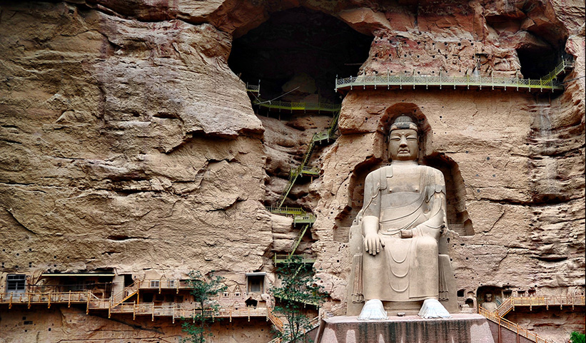
I then deviated towards southeast Gansu off the Silk Road and caught the bus to Liujiaxia from Lanzhou West bus station at 7. On arrival, I was mobbed by a gang of touts wanting to take me to Bing Ling Si. One walked away with my pack. Because of its inaccessibility, BINGLING SI was one of the few Buddhist grottos to have survived the 20th century unscathed. Over 1600 years, workers dangled from ropes to carve 183 niches and sculptures in the sandstone of the steep canyon walls. The stars of the site are the 27m high, seated statue of Maitreya, the future Buddha, and a 9m reclining Buddha. But much of the rest of the carving is exquisite and a lot of the paint is still bright.
Just below the grottos, the canyon ends at the reservoir on the Yellow River, hemmed in by a ring of dramatic rock pinnacles.
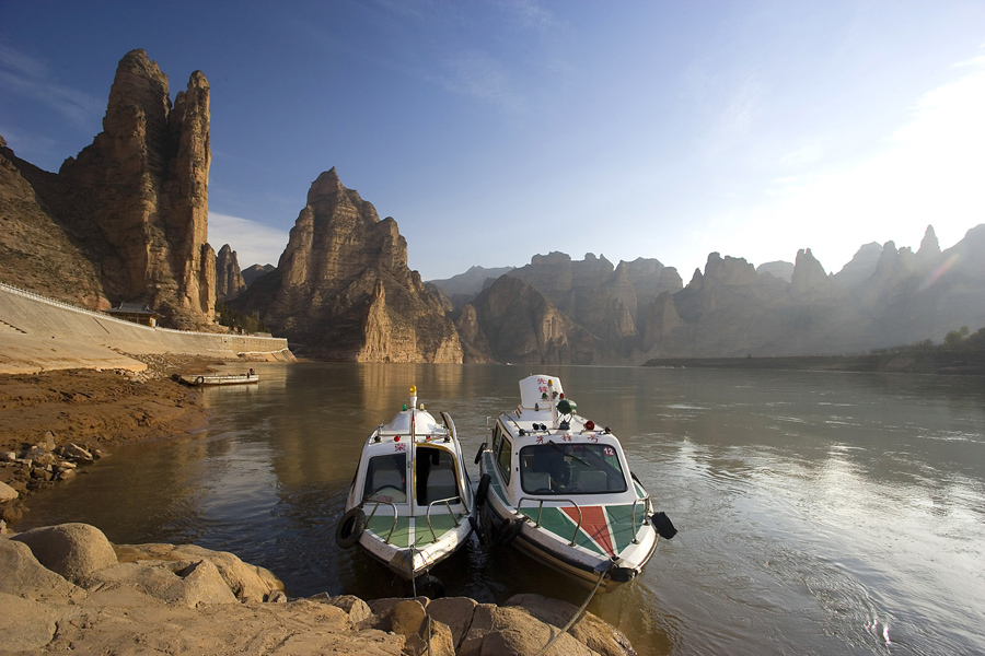
There are two ways to get there – a one-hour boat ride ($17) or a taxi, highly recommended by Lonely Planet because of the spectacular scenery. We climbed high above Liujiaxia through terraces, laddering every inch of tillable ground on the barren, dry hillsides. Potatoes and corn are the main crops. Looking down, there was an impossibly steep, narrow, rutted dirt track descending into the rugged canyon below. To my surprise, that was the route to the grottos. The landscape was stunning with erosional features, pinnacles and rock towers. Relatively expensive for a trip, it cost me about $35 for the 3-hour return journey. The ideal trip would be to take the boat one way and a taxi the other, but I doubt this is logistically possible.
It was then 2 hours to Linxia and another two hours to Xiahe. Bus travel is unbelievably cheap here. My several 2-3 hour trips in the last few days have cost about $4 each. And because the buses are not full, I have managed to have two seats to myself. I haven’t seen any Caucasians for 4 days.
XIAHE (pop 70,000).
This monastic town attracts many tourists. Most are rural Tibetans, here to pray and seek spiritual fulfillment at holy Labrang Monastery. The landscape has not changed much – all high hills. But as we ascended to Xiahe’s 2920m elevation, forests completely covering the mountains appeared sporadically. But most are barren, hard-scrabble-looking mountains. One can only imagine the intense deforestation that has occurred here over the centuries. The Xiahe area was once part of Tibet. The three ethnic groups represented here are Tibetan 50%, Han Chinese 40%, and Hui (Muslim) 10%. But despite the outward tranquillity, these groups don’t necessarily get along. The region was closed for 2 years after the 2008 riots in Lhasa.
I stayed at the Overseas Tibetan Hotel in a dorm room for about $9.
Labrang Monastery.
It was founded in 1709 by the first generation of a line of living Buddhas ranking third in importance after the Dalai Lama and Panchen lamas. Labrang is one of the six major Tibetan monasteries of the Yellow Hat sect of Tibetan Buddhism (the others are Danden, Sera and Drepung monasteries near Lhasa, Tashihunpo Monastery in Shigatse and Kumbum near Xining, Qinghai). At its peak, it housed 4000 monks, but the number greatly declined during the Cultural Revolution (called the anti-feudal revolution. Numbers are recovering and are currently restricted to 1800 monks, drawn from Qinghai, Gansu, Sichuan, and Inner Mongolia.

Access to most of the monastery is free, and you can spend hours walking around and soaking up the atmosphere in the endless maze of mud-packed walls. One of the best experiences is to show up between 6 and 7 am for the monk’s morning prayers. The Tibetans in the dorm rooms on either side had cleared out by 6.
Walking the kora is one of the highlights. This 3km path encircles the monastery and is the best way to grasp the layout, scale and significance of the monastery. Lined with long rows of squeaking prayer wheels, whitewashed chortens (Tibetan stupas) and chapels (many closed), most of the pilgrims on the kora appeared to be Tibetan with darker skin, traditional dress and a different facial appearance. Most were old, and some amazingly frail. Beggars were frequent. The 3-story Barkhang is the traditional printing press with 20,000 wood blocks used for printing. The Gongtand Chorten has access to the roof for views over the entire monastery. Tibetan monasteries are almost equal to the ones in Bhutan for opulent decoration: brilliantly painted frescoes, embroidery and carving.
Besides the kora, there are several main buildings that require a tour: the Institute of Medicine, Manjushri Temple, Golden Temple, Prayer Hall, and a museum of relics and yak butter carvings.
Some observations on China.
The grain harvest is in full swing. The small plots are full of women cutting the wheat and barley by hand with a sickle and then standing the sheaves to dry. Eventually the sheaves are loaded into little carts (occasionally pulled by donkeys) and taken for threshing. Hopefully they have a threshing machine. When I was a child in Southern Saskatchewan, we used to play in an old abandoned threshing machine – they have been out of date in North America for over 80 years. Despite China’s incredible technological achievements, agriculture is in the Dark Ages – no combines here. China has got where it is because Chinese people are hard working – and these farmers show what that means. A neat trick commonly seen is to lay all the dry sheaves on the roads and let cars drive over them to start the threshing process. Then they hand screen the grain!!
China has a ambitious tree planting program. Nurseries are common and most roads have rows of new trees – watered regularly and looking healthy. Some hillsides are being replanted. Most of the homes in rural towns have walls and courtyards.
China is an engineering marvel. Cranes dot the top of many new high-rises in every city. On one bus, a Chinese English teacher wanted to talk (he had not spoken to a native English speaker in 10 years). He said that most are empty as few can afford them. Despite the south being very mountainous, curves in the highway are few and tunnels numerous. The rock work holding back the steep hills lining the roads is amazing. Infrastructure is being modernized everywhere.
Except for the ubiquitous old men playing cards, not many people are sitting around doing nothing. Whole neighbourhoods are devoted to one trade – meat cutting in some Muslim neighbourhoods and small manufacturing enterprises in others. I have also not seen anybody horking and spitting. Has China started a publicity campaign or this just Gansu where they might not spit?
Transportation is all inexpensive. With taxis, the flag fall is 5 RMB and significant trips are usually less than 20 RMB. Water is priced as it should be – about 30 cents a litre.
The best sign over a urinal was: “TIGHTLY CLOSE TO THE CONVENIENCE OF CIVILIZATION” – all urinals have a pool of urine under them.
After a 5-hour bus ride with a transfer in Linxia, the bus let us off on the highway, not the bus station in Lanzhou. I had taken a chance on there still being a ticket on the high-speed train to Zhangye even though it was a weekend, but needed to get to Lanzhou West train station. Without a clue as to where I was and no empty taxis, I finally was able to stop a guy on a motorcycle and showed him the characters for the station that I had luckily gotten an English-speaking guy to write out for me (this station did not exist when this edition of the LP was written). The guy saved my bacon and I didn’t begrudge him when he soaked me for the ride. There were tickets available and I boarded at 17:40 for the 3-hour ride at the relatively slow 200km/hour.
The high-speed train system in China is a marvel. It recently surpassed Japan in size and of course, is expanding at breakneck speed. It is an engineering feat to create a route that allows these speeds in a country where all the land is used. Curves are long and most of the route is completely straight, so uses many tunnels and much of it is elevated above everything else. This was the 4th HS train today and the 8 cars with a 100 passengers each were mostly full. With so many people, China is able to develop these services in a cost-effective way.
ZHANGYE (pop 260,000)
The hotel I had picked had gone up in price since the last Lonely Planet (90¥ to 268¥!), so I asked if she had a cheaper room. Obviously not very busy, she gave a great deal at 138¥ ($23). Zhangye is supposedly the birthplace of Kublai Khan.
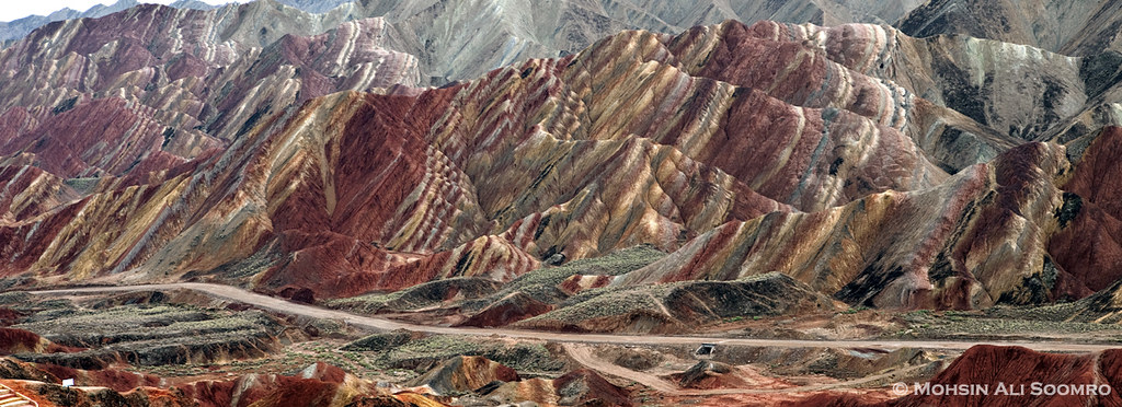
The taxi I took from the train station to town offered to drive me around for the day, cost 450¥. I have never done this before, but I decided to splurge. The clincher was a chance to see Danxia Rocks National GeoPark – six multicoloured rock formations recently inscribed as Unesco World Heritage Sites. The swirling rainbow palette and the scale of the formations is lovely. These are mudstone/flowstone formations – clay-based soft earth in layers. The area is very much like Dante’s Viewpoint in Death Valley NP (the surrounding mountains are also similar), and the colours are similar to the Bentonite Hills of Capital Reef NP or the hills around the Paria townsite area. A shuttle bus takes you between four viewpoints. A taxi is the only way to get there.

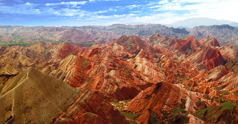
This is a panoramic photo of the entire area with the exaggerated colour palette of overdoctored photos. The following two are more characteristic.
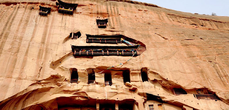
Mati Si. These are another set of Buddhist grottoes carved into the cliff sides of the foothills of the Qinian Mountains to the south of Zhangye. Translated as Horse Hoof Monastery (a heavenly horse apparently left a hoof imprint in the grotto), the series of caves was built between the 5th and 11th centuries in the sheer sandstone cliffs. The caves are reached via twisting staircases, balconies, platforms and narrow passages. I went to 3 sites – one had a massive grotto, but vandalism has been rampant, and much was destroyed and is now new.
Dafo Temple (Great Buddha Temple). Originally dating to 1098, this huge temple contains a 35m-long sleeping Buddha – the largest clay-covered, wood-core Buddha in China (I guess this is a big deal). Until the 1960s, children could play inside the tummy of the Buddha.
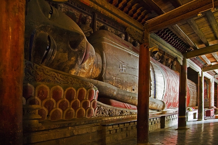
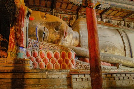
The main hall is one of the few wooden structures from this era still standing. The doors and woodwork are exquisite.

I took a 4-hour bus instead of a train to Jiayuguan.
JIAYUGUAN (pop 170,000)
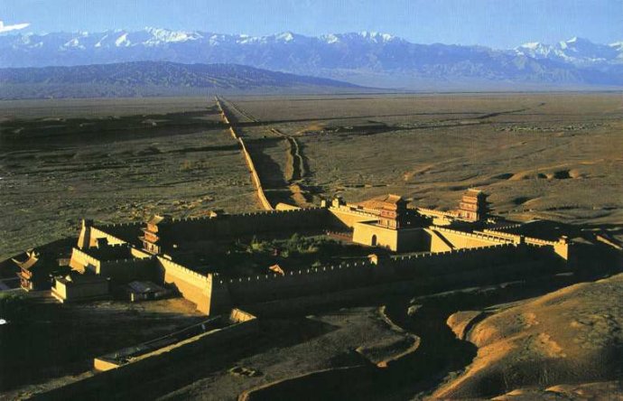
Approached through the forbidding lunar landscape of north Gansu, Jiayuguan marks the symbolic end of the Great Wall, the western gateway of China proper and, for imperial Chinese, the beginning of the back of beyond. Most of the walls date from the Ming dynasty, when over 8800 kilometres of wall were constructed or improved. After the fort was built, it was colloquially known as the ‘mouth’ of China, while the Hexi Corridor heading east was known as the ‘throat’. One needs plenty of imagination to conjure up visions of the Silk Road, as modern Jiayuguan is a city of straight roads. Jiayuguan is supposedly the source of rhubarb.
The fort and wall visits are included in one entrance fee (half price if over 60). These are not cheap as the regular price is over $20. I again received a huge discount in the hotel room. Take a bus to the fort and then a taxi to see the two sections of wall.
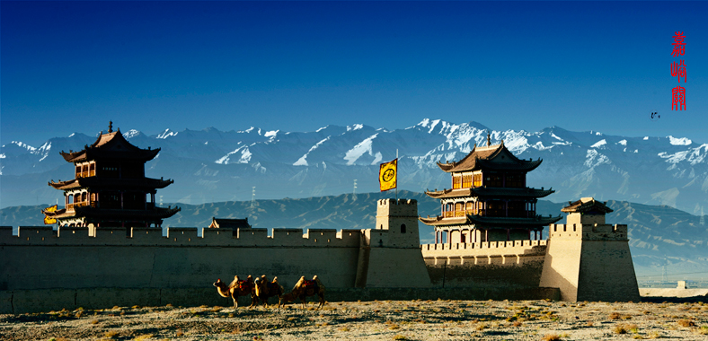
Jiayuguan Fort. One of the classic images of Western China, this Unesco World Heritage Site guards the pass between the snowcapped Qilian Shan peaks and the Hei Shan (Black Mountains) of the Mazong Shan range. Built in 1372, the fort was christened the ‘Impregnable Defile Under Heaven’. Although the Chinese often controlled land west of here, this was the last major stronghold of imperial China – the end of the ‘civilized world’, beyond which was desert and the barbarian armies of Central Asia. A rammed earth wall extends from and surrounds the over 10m-high walls of the actual fort. Horse lanes lead to the top of the walls, making for a great way to see the fort and beyond. At the exit is the excellent Jiauguan Museum of the Great Wall with many Silk Road exhibits. Photos taken in the early 20th century are compared to recent ones.
Overhanging Great Wall. Running north from Jiayuguan, this section of the wall dates to the Ming dynasty and the 1500s. This is totally reconstructed and quite different from the brick construction in the east – the walls are not nearly as high and are all rammed earth. It is a steep walk up to the watch tower at the top of the mountain to get great views of the snowcapped peaks in the distance.

First Beacon Platform of the Great Wall. This marks the very end of the wall – the rammed earth wall terminates at a 56m-high cliff overlooking the dramatic gorge of the Taolai River, a natural barrier. A museum has a subterranean viewing platform that is glass-bottomed. Then walk along the cliff to the remains of the beacon platform, now nothing more than a large mound of dirt.
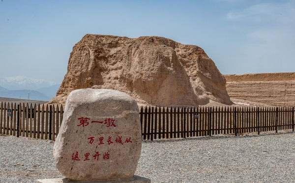
Using smoke during the day and fire at night, it was possible to send messages over 500 km in a few hours. As the river was eroding the cliff, a generous Japanese tourist paid for a large retaining wall to control the river.
After 2 nights here, I took the bus 5 hours west to Dunhuang. The train only goes to Liuyuan, 180 km north of Dunhuang. This was an impressive drive, not only for the stark desert landscapes but also because it is the centre of the clean energy program of China. In 2011, there were 2 dozen wind farms with 5000 turbines, and now there are many more. The industry centre is south of Jiayuguan. In 2005, the Chinese government pledged $700 billion to develop clean energy. By 2020, it is hoped that at least 15% of China’s energy will be produced by wind, solar, biomass and hydropower. Large-scale wind farms. The number of green energy companies exploded, and installed capacity outpaced the ability of the electrical grid to absorb it; components were substandard and malfunctioned. $590 billion was spent to upgrade the electrical transmission system. Eventually, it is hoped that China will have one of the cleanest systems in the world.
DUNHUANG (pop 187,000)
This fertile oasis town has long been a refuge for Silk Road travellers. Most stayed only long enough to swap a camel, but some settled and built the forts, towers and magnificent cave temples scattered over the surrounding area. Along with its sand dunes and deserts capes, this is a great place to visit. The town is now thoroughly modern but remains as much an oasis for the weary traveller as ever. There appears to be a large river flowing through Dunhuang, but it is really a series of dams producing terraced ponds only a foot deep. Cleverly constructed walkways with lights cross the ponds to “islands” – platforms with seats and trees. Wide promenades filled with people out strolling line the river.
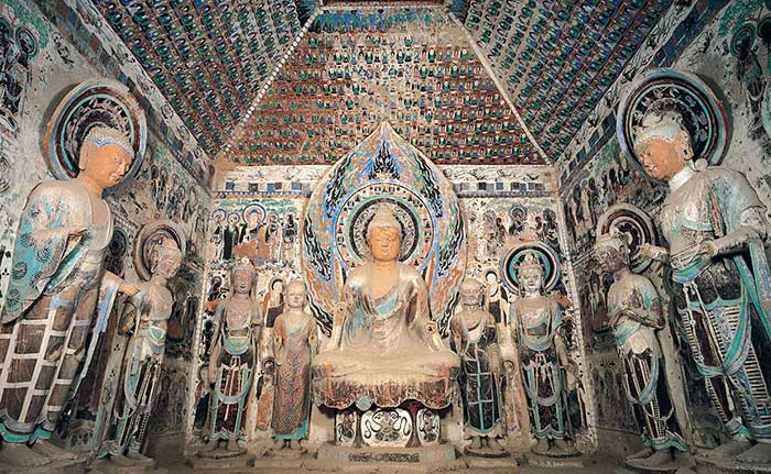
Mogao Caves. A Unesco World Heritage Site, these are one of the greatest repositories of Buddhist art in the world. First started in 368 AD, the site at its peak had 18 monasteries, more than 1600 monks and nuns, and countless artists, translators and calligraphers. Wealthy traders and important officials were the primary donors responsible for creating new caves, as caravans detoured to Mogao to pray and give thanks for a safe journey through the treacherous wastelands to the west. They were largely forgotten from 1300 until the 20th century, when they were “rediscovered” by many foreign archaeologists from 13 countries who visited and took priceless items (especially the 20,000+ manuscripts found in the library cave).
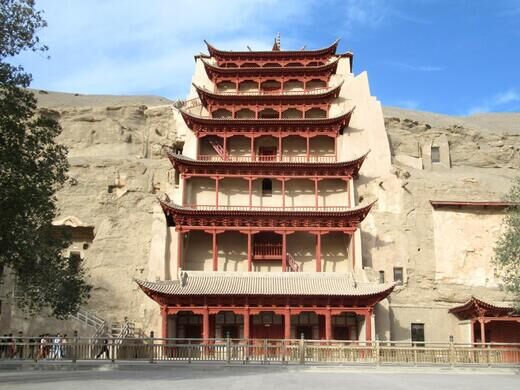
Mogao is 10 km east of town near the railway station and is most cheaply visited on one of the free city buses. In busy seasons, it is recommended to reserve tours as this is an incredibly popular place. It is also expensive, like most good sites in China – 220 yuan ($38). One starts with two excellent films (make sure to get the English headsets), one shown in a theatre with a huge round screen on the ceiling (think planetarium). You then get a free English-speaking guide, and I had her all to myself. The in-season tour only includes 6 of the 492 caves (20 are rotated regularly), but they are all spectacular.
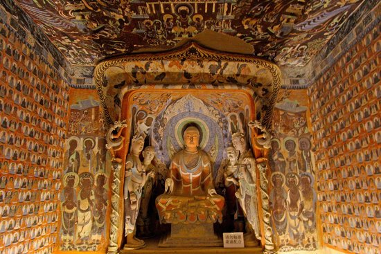
Cave #285
Northern Wei, Western Wei and Northern Zhou Caves. These earliest caves are distinctly Indian in style and iconography, with central pillars representing a stupa, slim statues with finely chiselled features. Lead-based paint, initially white, is oxidized to black. Sui Caves (581-618) still have Indian features. The 230 Tang Caves (618-907) are the high point as the Tang pushed China’s borders westward into Kazakhstan, bringing diverse trade. The murals are still beautiful with the paint, especially on the ceilings, is remarkable.
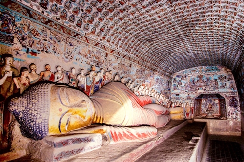
There are also two big Buddhas, one 26m tall and one 34.5m tall – a Maitreya Buddha, making it the world’s third largest Buddha.
The post- Tang Caves introduced Tibetan influences. The Library Cave (#17) was discovered in 1900 (the room was completely disguised) with tens of thousands of immaculately preserved manuscripts dating to 406, texts of rare Central Asian languages, military reports, music scores, medical prescriptions, Confucian and Taoist classics, Buddhist sutras and the oldest printed book in existence, the Diamond Sutra (AD 868). Almost all was removed to the West. An excellent museum is outside the cave telling the whole story.
Another good museum worth visiting is the Research Centre, where 8 caves are meticulously reproduced.
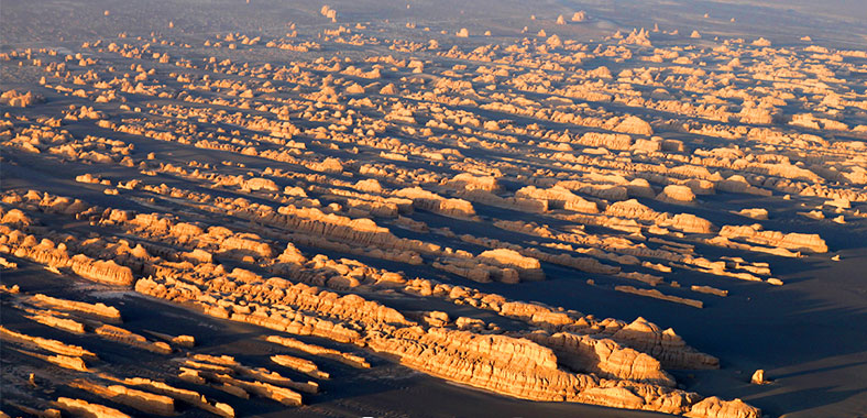
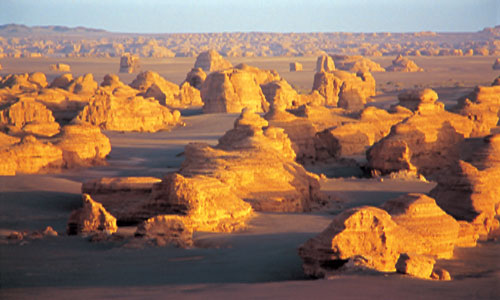
Yadan National Park. 180 km northwest of Dunhuang in the corner of Gansu, Xinjiang and Qinghai Provinces, is a part of the Gobi Desert that eroded into strange eroded landforms. The most practical way to get there is on a tour that stops at many other “attractions” on the way: Dunhuang Old Town (a fort with recreated town – not worthwhile the admission), Western Thousand Buddha Caves (have 4 ruined murals not worth the price but it is a beautifully cool place with trees next to a river), Jade Gate Pass (originally a military station, is now another large walled fort with an OK museum), Hecang Cheng (a ruined city wall sitting next to a lake), and a section of Han Great Wall (rammed earth, it is amazing that these walls dating to 300 BC are still standing.
The tour starts at 10:30 so that you reach the last of the four viewpoints in the National Park at sunset. The desert is unbelievably forbidding – flat gravel with nothing growing. The formations are best described as eroded, monochrome yellow, hard stratified dirt. The first 3 viewpoints are mediocre but the last with long, parallel formations is quite spectacular, especially in good light (they remind me most of the grabens in the Needles District of Canyonlands NP which are sandstone).
It ended up being a long, expensive day as I paid admissions to everything. We arrived back in Dunhuang at 23:30, and I went with several young Chinese women who had been incredibly helpful all day to the Shazhou Night Market to feast on fiery kebabs, BBQ veggies, and beer.
The next day was basically a day off to organize things: I ended up getting all my train tickets all the way to Kashgar (it will be an intense 5 days of travel. Many of the trains had few sleeper beds available, even it is almost 3 weeks away. I then took the bus 3 hours north to Liuyuan, hoping to catch the high-speed train to Turpan.
