
Hunan (pop. 66 million)
The birthplace of Mao Zedong, Hunan is important historically. Communist Party enthusiasts can visit Shaoshan to join the masses paying homage to him.
But the dramatic scenery is the real draw. An astonishing landscape of massive, isolated mountain ranges and jagged, karst peaks cover more than 80% of the province. Dahang and Zhangjiajie in the northwest are the two big mountain draws. The rivers form part of the Yangzi River basin. Many diverse cultures live on the hillsides taming them with terraces.
History. During the Ming and Qing dynasties, Hunan was one of their granaries, transporting vast quantities of rice to the north. By the 19th centuries, land shortages and feudalism caused widespread unrest among farmers and hill-dwelling minorities. This galvanized the Taiping Rebellion in the 1850s and subsequent widespread support by the 1920s for the Chinese Communist Party and Hunan’s Mao Zedong.
Climate. Subtropical, the mostly temperate climate averages 25°C in summer and 6°C in its brief winter. Monsoon rains fall from April to June, followed by high temperatures and humidity in July and August. The northern regions may even get snow occasionally.
Transportation. A high-speed rail line connects Hunan with Hubei and Guangdong running along its eastern border areas. Airports are in Changsha, Zhangjiajie and Huaihua.
I took a bus north from Sanjiang in Guangxi to Jishou. I purposely missed two common tourist draws. Hongjiang Old Town was a Qing financial and trading center, once the opium distribution hub of SW China. The old town is a maze of steep alleys and lanes where getting lost is routine. Fenghuang was a Ming centre of trade with a riverside set of alleys, temples and rickety stilt houses. The old town has a collection of halls, homes and temples. Like so much of China’s old towns, I imagine that much has been restored and frankly, I have already seen enough of them.
The southwest corner of Hunan the bus travelled through is totally off-limits to foreigners as it contains a sizeable proportion of China’s intercontinental ballistic missiles, many disguised as wind and rain bridges. I met two Quebecois cycling through China who were unaware of the restriction, taken out of the restricted area and promptly put on a through bus.
NOMAD MANIA HUNAN SOUTH
World Heritage Sites:
China Danxia
Tentative WHS:
Jinggangshan–North Wuyishan (Extension of Mount Wuyi) (30/01/2015)
Religious Temples Hengyang: Shangfeng Temple, Zhusheng Temple
NOMAD MANIA HUNAN NORTH
World Heritage Sites:
Wulingyuan Scenic, Historic Interest Area and National Park
Tusi Sites Designated World Heritage Sites in 2015, the tusi was a tribal leader appointed as officials by the imperial government in imperial China. It is a political system adopted by Chinese emperors to govern ethnic minority regions in south-central and southwest China. The system was used for a thousand years.
| Name | Location | Coordinates | ||
|---|---|---|---|---|
| Laosicheng Tusi Domain | Yongshun County, Hunan | 28°59′55″N 109°58′01″E | ||
| Tangya Tusi Domain | Xianfeng County, Hubei | 29°41′26″N 109°00′19″E | ||
| Hailongtun Tusi Fortress | Huichuan District, Zunyi, Guizhou | 27°48′42″N 106°49′01″E |
Tentative WHS:
Fenghuang Ancient City (28/03/2008)
Heaven Pit and Ground Seam Scenic Spot (29/11/2001)
Railway, Metro, Funiculars, Cable Cars:
Jingguang High-Speed Railway (Beijing-Guangzhou)
Religious Temples Changsha: Kaifu Temple, Lushan Temple
Statue of Mao, Juzizhou, Yuelu. Orange Isle is in the centre of the Xiangjiang River in Changsha, the biggest inland island in China. Abounding with sweet and delicious oranges, people gave it the name Orange Isle, or Juzi Island in Chinese.
In 1925, Chairman Mao Zedong visited and wrote a famous poem, ‘Changsha Tune – Spring in a Pleasure Garden’, to praise it and express his willingness to build a new country and made Orange Isle known worldwide.
Mao Zedong’s Statue is based upon the image of a 32-year-old Mao in 1925. Built with reinforced concrete, it has a granite surface. 83 X 41m 32m high, the statue aims to show Mao Zedong’s positive image and encourage young generations.

Giant statue of young Mao
Lucky Knot Bridge. A 185m red steel bridge that crosses Dragon King Harbour River in the Meixi Lake district, a 6.5 million-square-metre development. The bridge’s wavy form is based on the Möbius strip and the ancient Chinese decorative folk art of knotting. The bridge literally knots together and connects many levels of road, river bank and park at many different heights. It has its own LED-light show.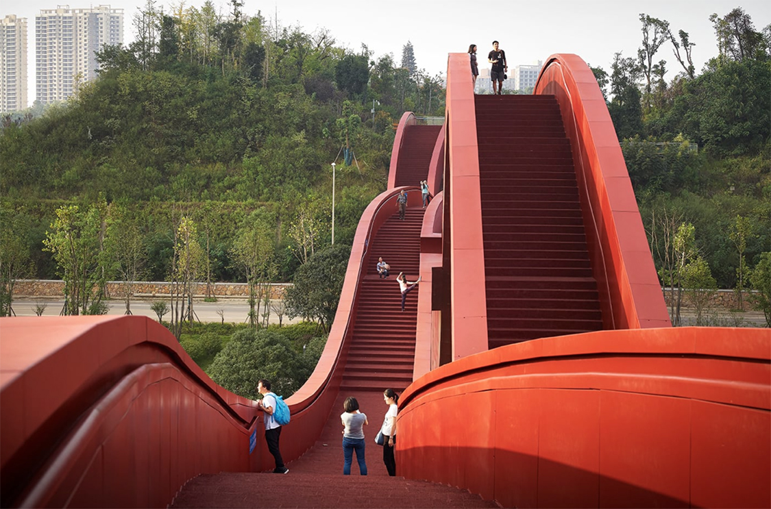
In a well of the Ancient City Ruins of Liye built in the Warring States period and abandoned in the late Qin dynasty, more than 36,000 pieces of bamboo slips, the official files of Qianling County of Dongting Prefecture carry almost all the political, military, economic and social informations (encyclopedias) of the Qin dynasty.

About an hour NW of Jishou, this is a magnificent karst landscape with several hikes (admission 100¥). The karst here is different from that in Guilin/Yangshou where it is rounded and thus covered with vegetation. Here the walls are sheer forming great towers of white/grey rock that end in chimneys and pinnacles. All hikes lead out of the town square.
Yuquanzi Scenic Area is a valley that turns into a narrow canyon. The path, like all in China is stone, crossing the creek on boulders. It was disappointing to see so much garbage along the trail despite there being more garbage cans than I could count. Citrus fruit peelings take years to degrade and are thrown everywhere. I spent almost 2 hours in the beautiful canyon before returning to the square and theatre where there was a traditional dance show. All the people here are Miao and their fields extend for up each valley.
Nine Dragon Stream Scenic Area is up another canyon leading to the Liusha Waterfall, China’s highest at 216m. It falls off a large overhanging cliff making it possible to walk behind the falls. At this time of year and with little rain, the waterfall was a faint spray.

After returning to Jishou, I caught the train (hard seat 19¥) to Zhangjiajie City to stay in a hotel for 3 nights. The train ride was through very mountainous terrain via an uncountable set of tunnels and bridges high above the valleys below.
ZHANGJIAJIE NATIONAL PARK (Wulingyuan)
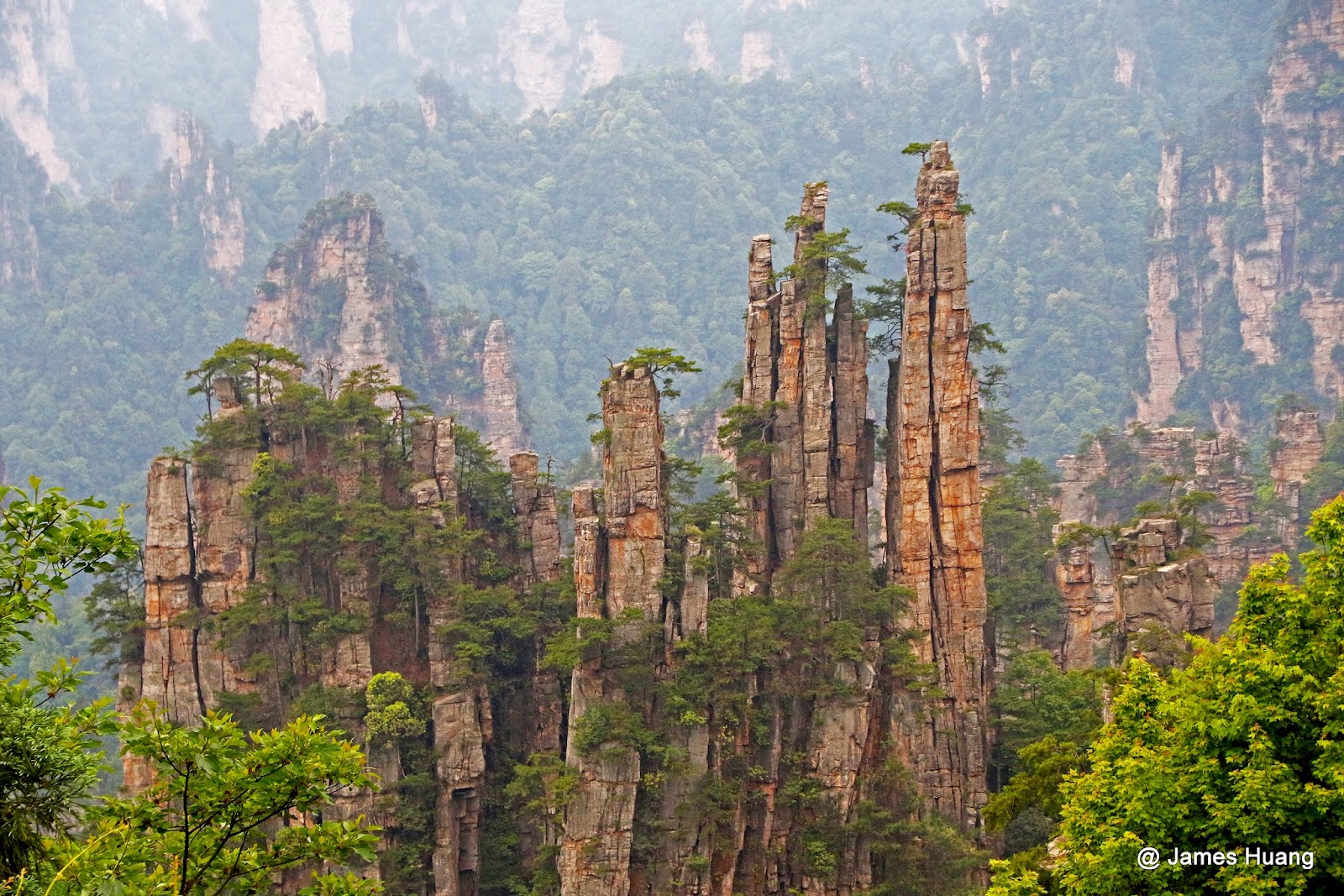
Declared a Unesco World Heritage Site in 2004, this 364 sq. km park in the subtropical/temperate area of northwest Hunan has a concentration of quartzite-sandstone formations found nowhere else in the world. Some 243 peaks and more than 3000 pinnacles and columns dominate the landscape. 198 columns are 200-300m high and 48 are over 300m high (Jinbian Rock is the highest at 380m). The 15km long Jinbian Brook has the highest concentration of columns with 400. The columns of rock are formed as a result of tectonic forces and water weathering.
Although resembling karst terrain, this area is not underlain by limestones and is not the product of chemical dissolution, which is characteristic of limestone karst. They are the result of many years of physical, rather than chemical, erosion. Much of the weathering that forms these pillars are the result of expanding ice in the winter and the plants that grow on them. The weather is moist year round, and as a result, the foliage is very dense. They rise almost square in shape straight up from the valley floors. It is home to a wide biodiversity of plants and animals including macaques, giant salamanders and clouded leopards. 20 million visit the park annually.
One of the park’s quartz-sandstone pillars, the 1,080-metre (3,540 ft) Southern Sky Column, had been officially renamed “Avatar Hallelujah Mountain” in honour of the film in January 2010.

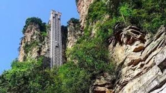
The towering Bailong Elevator, literally ‘hundred dragons sky lift’, was opened in 2002. At 326 m (1,070 ft), it is the world’s tallest outdoor lift. It can transport visitors to the top from its foot in less than two minutes. The structure is composed of three separate glass elevators, each of which can carry up to 50 people at a time.
In 2016, Zhangjiajie Grand Canyon opened the Zhangjiajie Grand Canyon Glass Bridge, the longest (430) and highest (300 m) pedestrian glass bridge in the world. Thirteen days after opening, the bridge was closed due to the sheer number of visitors. It reopened on the 30th of September 2016 after having adjusted the logistics and safety measures for handling large numbers of tourists.
I picked an unfortunate day to go as it was raining, cold, windy and everything was obscured by cloud. But I avoided the hordes of people and saw virtually no one. It often rains here and even on good days, mist and fog obscure the sights. I caught a bus from the station five minutes from my hotel. The bus arrived at the main south entrance. The exorbitant 245¥ entry is 50% less for seniors over 60, and is good for three days.
The park is divided into four scenic areas.
1. Huangshi Village. From this entrance, this is the only practical part accessed – a 16-hectare plateau 1068m above the canyon floor. It is possible to walk up the 3878 steps or use a bus and a cableway (cost 65¥, 40¥ for seniors over 60), which is what I did. A 3.5km stone pathway travels the circumference of the plateau with viewpoints to many of the amazing rock formations, none of which I saw in the whiteout conditions. It was a walk in the woods. The path had an elaborate cement “wood fence”. Every “cut” surface had a clay-like covering painted intricately with the rings of a tree – over the top or what!

I took the stairs down and passed many rock towers and columns. By now it was raining heavily so I headed back to Zhangjiajie City.
2. Golden Whip Stream Scenic Route. From the south entrance, it is also possible to walk 7.5km into the centre of the park. Coming off this to the south is 3. Baiying Valley.
The next day, I returned and took a bus to the Wulinyuan Entrance on the east side of the park to see the other two big areas. I caught a bus to the Bailong Sky Lift, a cliff-side elevator that rises 335m to access the
4. Yuanjiajie Scenic Area in the middle of the park. The viewpoints from the top of the elevator look over a sea of columns. After the elevator is a 5-minute walk, then an 8-minute bus ride through a boring bit before coming to a walk on the edge of a cliff with Shadao Stream more than 300m straight down. The cloud and mist cleared enough to get good views of the fantastic columns. A natural bridge 300m above the floor is crossed at one point.
I then boarded a bus with several possible stops:
5. West Yuanjiajie Scenic Area
6. Laowuchang Valley
7. Dagyandal Valley and finally
8. Tianzi Mountain. From a central area one can walk along a more challenging ridge.
At the south end is a glass plank suspended over the cliff face and an escalator to allow views of Tianmen Cave, a huge arch. The escalator descends to the valley floor. To avoid the walk, the other option is the Tianzi Cableway that descends amongst another series of fantastic columns back down to the main road and the bus that returns to the Wulinyuan Entrance. The top was totally socked in and it was raining and cold, so I opted for the cableway to return to Zhangjiajie City and my comfy hotel room.
There are easily three full days of hiking available in Zhangjiajie National Park. Crowds were large on this rainy, cold, no-view Tuesday in late November. I can only imagine what they might be like on a weekend in peak season with a nice day. The ethereal landscape here is not to be missed. Nothing else like it exists in the world.
I don’t think I have seen so many signs with stilted English as in this park. The signs are large wood billboards, rock with incised letters and other expensive productions. Brochures are similarly written badly. Names of viewpoints and natural features are very poetic. There was an unfortunate amount of garbage littering the trees below the cliffs despite there being lots of garbage cans. Trails are also littered with signs warning of dangers: slippery paths, rockfall, danger of falling into creeks. It seems that Chinese need a lot of babysitting. Almost everything has a long list of rules concerning behavior and possible problems. A small bench swing on the Yangzi tour boat had 6 instructions on safe use! Maybe they find Chinese as non-intuitive as I do.
After a third night in Zhangjiajie, I took a bus four hours southwest to Changsha, the capital of Hunan Province. It was then the high-speed train east to Nanchang, the capital of Jiangxi Province on my way north to another Unesco Site, Lushan.
