
KAYAKING GWAII HAAHAS NATIONAL PARK – June 3rd to 16th, 2013
The Queen Charlotte Islands conjure images of one of the world’s premier kayaking destinations, ancient Native culture, wildlife, hot springs, old-growth forests, and rain. With a like-minded friend and all the time in the world, we were both fulfilling a long-time dream. The goal was to see everything between Moresby Camp in the north and SGang Gwaii in the south, and hopefully, depending on the weather, both the inside and outside of all the islands.
With 7,000 residents, there are 3 main islands in the Charlottes – from north to south, Graham, Moresby, and Kunghit in a triangular-shaped group of 150 islands, 250 km long and 85 km at the widest north end. Moderated by a northeast moving current, the annual average temperature is 7.8 C (46 F). Only 135 cm (53”) of rain falls on the east side of the mountains. Alaska is 48km away. Most kayaking interests centre on the east side of Moresby Island and the Houston Stewart Channel between Moresby and Kunghit Islands. The name of the islands was changed from the Queen Charlottes to Haida Gwaii (“Islands of the People”) in 2001.
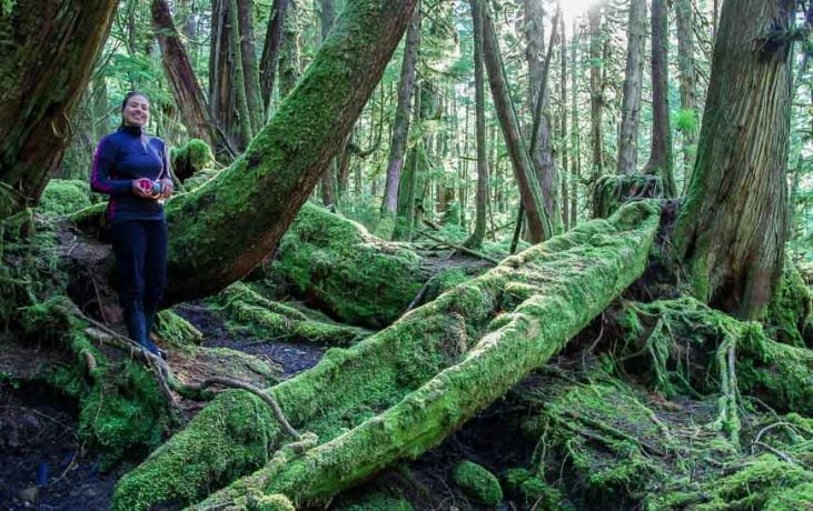
The jewel of Haida Gwaii is Gwaii Haanas National Park (“Place of Wonder”) – 138 islands covering the entire south, and the center of an epic wilderness battle over logging old-growth forest that captured the attention of the world. With 1,600 km of coastline, 4000-foot mountains with alpine gardens, 42 freshwater lakes, ancient Haida village sites, an old-growth forest of some of the greatest trees on earth, whales, porpoises, seals, Canada’s highest concentration of bald eagles, and seabirds, it is Canada’s Galapagos.
The Haida arrived on the islands at least 12,500 years ago. By the time of first contact in 1787 (which occurred at Ninstints), there were between 15 and 30,000 Haida. They were one of the most powerful Northwest Native tribes with a culture at the apogee of the entire coast, famous for their warrior culture, immense cedar houses, their myths and their totemic art. The most advanced hunter-gatherers on earth, they did not farm but lived off the spectacular year-round bounty of the ocean. Their cedar canoes were the biggest and best in the world, 18.3 meters (60 feet) long and the most important trade item for the Haida. It wasn’t unusual for them to visit the mainland coast, paddle the 1,600 km round trip to Victoria, and apparently, they went as far south as California. They could raid the mainland tribes, seize goods and slaves, and return to Haida Gwaii with impunity, as no one would follow across Hecate Strait, a formidable body of water.
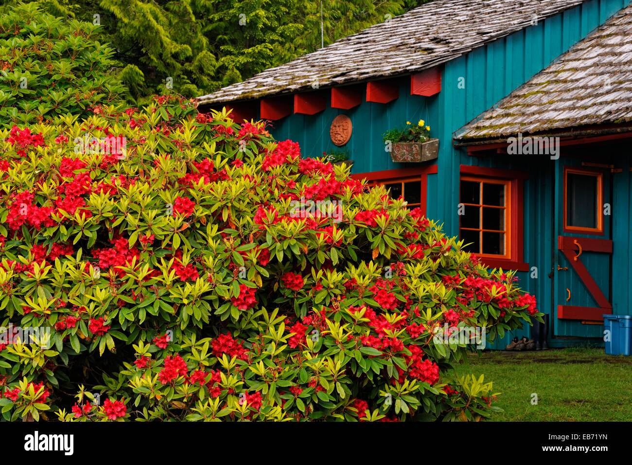
From Vancouver Island, we caught the first ferry to Horseshoe Bay in West Vancouver and over two days drove to Prince Rupert on the north BC coast. We finished some grocery shopping before boarding the 11 PM ferry that plies the 93 nautical miles of Hecate Strait to Haida Gwaii. Cabins are available but most passengers were sleeping on the floor in front of seats in the lounge. Arriving at 6 AM, we had breakfast in Queen Charlotte City and nosed around the old band office in Skidegate. Built-in a traditional long house design and fronted with a great Bill Reid pole, it is now the home of the Skidegate Haida Immersion Program (SHIP) devoted to reviving the Haida Language. The elders are working on the challenging task of standardizing the written form of place names. The names continue to change as it is difficult to capture the dialects and decide on the spelling.
Day 1. We had the mandatory National Park orientation at 9 AM at the Heritage Center containing the excellent museum. Leaving with a 100-page Visitor Guide, several brochures and a permit, we boarded the 20-minute ferry to Alliford Bay on Moresby Island and drove 32 km to Moresby Camp, our launch site.
We finally launched from Moresby Camp at 2 PM on June 3rd into a brisk easterly coming down Cumshewa Inlet. The hope was to paddle on both the outside and inside of all the islands on the east side of Moresby. Hecate Strait is a big body of water and functions much like the open ocean with swell and surf on exposed beaches. We would have to take advantage of any good weather to be on the outside. Today it seemed that paddling on the outside of Louise Island would be a poor choice so we headed south through Carmichael Passage on the way to Louise Narrows. I was too cheap to buy the large-scale marine charts for the very north part of the trip involving Louise Island (with a scale of 1:90,000, these are poor maps anyway), so we were using photocopies of maps taken from “Boat Camping Haida Gwaii – A Small Vessel Guide”, Second Edition by Neil Frazer. This is the great guide I used to organize the entire trip. The maps are labelled with the warning, ‘For Navigation use CHS 3894.’ As a result, I was not sure in which direction Louise Narrows would be flooding nor the maximum speed of any current. I seemed to remember that maximum flow was 12 knots but that would be with the biggest tidal ranges of 24 feet. Today’s range was 11.2 feet.
Low tide was at 16:50; it was now 17:00, and we were 4 km north of the narrows. It seemed unwise to continue, but as the time of turn often differs considerably from low tide, and as there was no camping on this side of the narrows, we decided to go for it. With the worst scenario, if the turn occurred an hour before the low, it would be 2 hours after the turn when we arrived, with a maximum current speed of 6 knots, the 50/90 rule predicted the speed would be 5.4 knots. If it flooded north, it would be impossible to paddle into and if it flooded south, too fast to maneuver our boats. We arrived at the start of the narrows at 17:45, one hour after low tide, but it appeared to be at slack. This is an incredibly narrow body of water, especially at low tide. The turn appeared to occur at 18:00, flooding north (on the east side of Moresby, it floods north and east). The narrow parts of the channel required some work paddling against the current. A deer swam across the narrows in front of us and stood watching until we were well past. After paddling for 4 hours, we landed just outside the narrows on the east at a reasonable campsite.
Day 1 distance: 18kms.
Last week, we completed a 10-day circuit of the Broughtons, travelling about 240km on 8 paddling days. It was a great shakedown for this trip. Several things were left behind, and a few forgotten things were remembered. We were in good shape and had developed a routine – up at 5, paddling by 7, wet suits every day. It was June 3rd, and we were confident that we could catch the night ferry 18 days hence on June 20th. Parks told us it was 142 km to SKang Gwaii, an easy 7 days each way, so we had 2 weather days per week built in for safety (as it turns out, this is the direct line of flight distance!!).
Day 2. Tired, we slept in till 6 and were off at 08:15 in perfect calm. A loon gave a ‘call of the wild’ in our bay. The colour palette was of muted greens and blacks in the low overcast. Cool, the paddling conditions could not be better. After 2 hours to Selwyn Point, we turned south into Dana Passage and then Dana Inlet on the south side of Talunkwan Island. The first harbour seals greeted us, raccoons roamed the shore, and grouse drummed in the woods. The water was coated with large swaths of rust orange wherever there was no current. We wondered if this was a red tide (which it was). The algae blooms are often invisible, and the toxin is stored in shellfish. It is usually difficult to know if it is affected, so all shellfish harvesting is closed in Haida Gwaii. The entire surface of Dana Inlet had a thin layer of algae. We wondered how the raccoons and all the other animals that depend on shellfish handle red tide and paralytic shellfish poisoning. We stopped for lunch at McGee Point, a popular campsite with room for many tents.
Rounding the Tangil Peninsula, we entered Gwaii Haanas National Park Reserve, National Marine Conservation Area, and Haida Heritage Site. The very long name is the result of the Haida Nation and the Government of Canada negotiating a deal to protect and manage all of the territory south of this point. A 15-knot westerly blew out of Logan Inlet, and Flowerpot Rock didn’t provide much protection. Reaching the NE corner of Tanu Island, I called the Haida Watchman at Tanu on channel 6. “We’ll meet you at the beach”. We went to the north beach, they went to the south, and it took a while to connect. A pleasant elderly couple and their adopted granddaughter were here for a month.

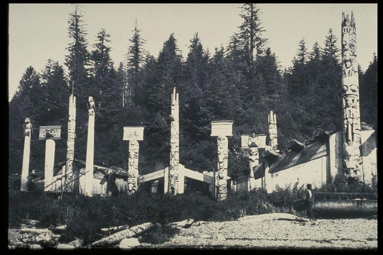
Tanu 1848
In 1840, Tanu (“Eel grass town”) was home to 545 people in 40 long houses, each with 20-30 people. In 1878, it was thought to be the most flourishing village in the entire islands. But after only 6 years, there were 150 left and three years later just 80, and most were sick and dying. The survivors were moved to New Kloo on Louise Island where they lived or died for another decade before joining the island-wide exodus to Skidegate.
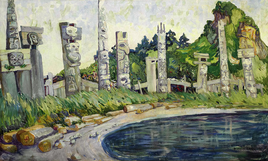
Most of the house sites remain visible with corner posts, the bottoms of the frontal poles and many long roof beams, all covered in a thick coating of moss. The chief’s houses were usually multistory with pits and this chief had a stream in one corner. The frontal poles not taken by museums “all over the world” had been laid on their faces and these had now rotted away. Although there were once 31 mortuary poles and 15 mortuary houses, little is left standing today. There are no poles now and no point in repatriating them with no room to display them in the museum.
The Haida village sites had several requirements: a good year-round water source, 2 good beaches and thus dependable landing in case of weather, protection from the worst storms, and a reliable bounty of food. Tanu has 2 great beaches and a canoe run in the middle of the rocks in front of the longhouses. The spirit of the place is still strong.
The Haida family held large numbers of people together – grandparents, cousins, parents, and siblings. Every child was precious to a hundred people. If he wore the eagle crest, he had descended from Copper Woman (who lived in Pallant Creek next to Moresby Camp), and every Eagle would defend him. If from the Raven or Killer Whale clans, he was descended from Foam Woman. Each Eagle and Raven divisions were divided into matrilineal families or clans. Marriage was disallowed within clans but was encouraged between Eagles and Ravens. When a chief died, his nephew took his name keeping the lineage clean. They glorified their powers and superiority through their art and craft. Cedar provided the basis of everything: the bark was woven into mats, baskets and clothing, and the wood was used for utensils, tools, storage boxes, buildings, art and canoes.
We crossed Klue Passage to the campsite on the SW corner of Kunga Island. This beach is often used by tour operators due to its proximity to Tanu. It is also a great place to get dropped off by the shuttle companies avoiding 2 days of paddling from Moresby Camp. Day 2 distance: 36.5km
Day 3. Is this the Charlottes? Off at 7:30 in bright sunshine, distant clouds and calm water, we had to shake our heads to realize we were in the right place. We had a long 1½ hour crossing to Dodge Point on the NE corner of Lyell Island. This whole side of Lyell, exposed to the fury of Hecate Strait, is picturesque with sculpted rocks, tons of rock gardening, small cliffs and trees growing from impossible perches. Huge beds of kelp kept us paddling offshore. Another 1½ hours brought us to Windy Bay, another Haida Watchman site. The Watchmen were not here yet, but the cabin was full with a group down to clean up the area in preparation for the pole-raising ceremony here on August 15 to celebrate the 25th anniversary of Gwaii Haanas. The pole is presently being carved in the shed next to the Heritage Center and will be the first pole raised on Moresby Island in over 100 years. The Haida are very excited about it.
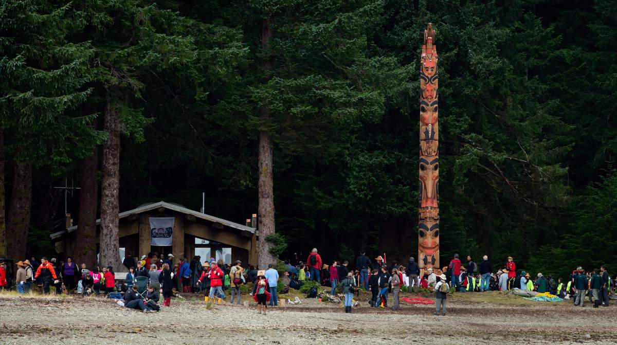
Windy Bay is famous as the main protest site in 1985 against logging Lyell Island. Their protest ultimately led to the protection of the area and the creation of Gwaii Haanas. A long house was built for the protesters. It contains several bunk beds on the sides and a big table in the middle, and is available to kayakers for one-night stays. A trail goes to a 900-year-old Sitka spruce. Clouds blew in, and it turned cold in the shade of the old-growth trees.
The sculpted rock shoreline continues south of Windy Bay. The entire watershed of Gate Creek has been logged. A black bear was rummaging around on the beach. This subspecies is the largest black bear in North America and has larger jaws and teeth to deal with shellfish. Two humpback whales put on a spectacular show of tail slaps. After a few slaps, they would swirl in tight circles, churning up the water. They continued the entire length of the Gogit Passage. This is a method humpbacks use to fish for krill.
Gogit is a line of islands separating it from Hecate Strait – the Tar Islets, Kawas Islets and Agglomerate Island that lead down to the north tip of Murchison Island. An hour after high tide, we were able to paddle next to Murchison’s east shore to the “Gap” campsite for lunch. Murchison Island is infested with rats.
With the bad weather forecast for the next day, we decided to see Hot Spring Island and then find a campsite to hunker down for a day or two. Heading into a 10-knot southerly, we passed the “Maple Leaf”, a tour boat, in the bay to the east of Hotsprings. The beach here gives access to a 10-minute trail that crosses to the west end of the island and the hot springs. Most kayakers land on the SW beach. The Watchman cabin here is a beautiful traditional design with 2 roof beams. Unfortunately, a 7.7 earthquake (the second strongest ever in Canada) on October 27th, 2012, stopped the 26 small springs that feed the hot pools. Parts of Haida Gwai moved more than a metre during the quake and continued to move to the southwest afterwards. On Moresby Island, kelp was hanging from trees, salmon were thrown 20m into the forest, and 3m logs were moved by what is believed to be a four-metre-high tsunami. It is believed that this tsunami was highly focused and aimed only at the southwest corner of Mosby Island.
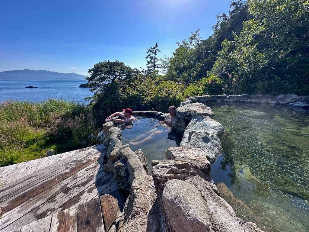

Only a small, shallow pool at the base of the cliffs had any hot water. It is slowly getting hotter and producing more water, so everyone is optimistic that the springs will return. The last time the hot springs stopped occurred after an 8.1 earthquake in 1949. Then it was two years before the springs returned. Tourism, especially to the northern part of the park, has already seen a significant decline, and most of the tour boats have stopped coming to Hotsprings Island. There are two private houses here, a private pool, the cliff pool and the huge lower pool, all dry. An eyewitness reported that the pools were dry within a few hours of the actual earthquake. It is thought that the water in the pools was fresh water originating on Lyell Island.
Haida Gwaii is one of the most seismically active places on earth. 200 million years ago, there was no British Columbia. The continent ended, and the Pacific Ocean began close to today’s BC-Alberta border. The continental plate moved westward, adhering to pieces of the earth’s crust called terranes, and land mass was slowly added to BC. The terrane Haida Gwaii includes Vancouver Island and a portion of the mainland coast. It originated near Peru, joined another terrane 140 million years ago and 40 million years ago, the combined fragments “docked” on the edge of North America. The Pacific plate meets the North American continent on the west coast of the islands. After a gradual descent for about 5kms, the depth plunges 2.5kms to the ocean floor. The Pacific Plate is creeping northward at a rate of 5-6 cm a year. As we have paddled south, we have noticed what appear to be landslides scarring steep hillsides. Being Canada’s most active earthquake area, these slides are initiated by seismic activity and/or heavy rainfall.
We decided on the nice campsite on the north side of Ramsay Island. It sits on the west side of an isthmus of a peninsula in the middle of the north shore. Two ravens met us as we landed. These guys are experienced thieves and lose no time getting into Charlie’s bread. They also extract my fishing license through a mesh pocket on my deck bag.
Day 3 distance: 33km.
Day 4. This is a welcome day off and a chance to catch up on both sleep and reading. 30-40 knot southeasterlies are forecast. We feel little until surf starts in our bay in the late afternoon and gusts sweep across the bight of our peninsula. Deer walk through the trees next to our tents and cross the beach. These Sitka black-tailed deer were introduced in the 1880s and again in the 1900s to supplement people’s diet. Their intensive browsing severely disrupts native ecosystems.
The last glacier receded about 15,000 years ago, leaving sharp mountain peaks, rounded hilltops, steep valleys, fjords, mudflats and sand beaches. Small parts of Haida Gwaii escaped the last ice age, and the isolation has meant that species evolved with unique characteristics. Six of the ten mammals are distinct subspecies and in all, there are 39 unique plants and animals. When the first Haida arrived on the islands about 12,500 years ago, the ice had receded, leaving a tundra-like environment. Alder and lodgepole pine arrived 11,000 years ago, Sitka spruce and western hemlock 9,000 years ago and red cedar first appeared about 7,000 years ago. There are 10 native land mammals on Haida Gwaii, of which only the black bear is very noticeable. All the other mammals have been introduced by man. Rats arrived on the first boats, raccoons were brought in the 1940s for fur, red squirrels in the 1950s to gather spruce cones, and 7 other mammals have been introduced for various reasons. They adversely affect all birds, including seabirds, shorebirds and songbirds.
We read, nap, eat, read, nap. The beach is big with a good trickle stream on the west end. We replenished all our water. There are two huge cedars here. One has a smooth burnt core into which you could cram 6 or 7 people. A small headland past the creek is moss heaven. The beach was absolutely clean without a speck of garbage. The water was crystal clear. We are told to defecate on the beach. It doesn’t seem right. When I think that Victoria still dumps all its sewage raw into the ocean, I guess this is OK. We burn our toilet paper – that doesn’t degrade. When I checked out my previous day’s “deposit”, it had completely disappeared. I know that shellfish farmers don’t like intertidal defecation.
It was good that Charlie was obsessed with tarps. When we had three tarps on our last trip, all three were up but for this trip, we have brought only the two silicon tarps that pack up very small. The 8×10 makes a great cover for the kitchen. Charlie is an engineer and he puts up a great tarp. I take notes.
Day 4 distance: 0 km.
Day 5 (June 7th). Despite a forecast of 15-knot westerlies and south-westerlies, we decided to go for the six-km crossing of Juan Perez Sound directly into the predicted wind. After leaving the protection of Ramsey Island, we immediately were in 10-knot winds and moderately big wind waves. We managed, but when two-thirds across, the wind squalled to 20 knots and white caps were everywhere. Our speed decreased from 4 to 3 km/hr. It was cold and raining hard. Charlie’s boat is considerably faster, and I can’t keep up unless I go all out. I had to take a pee. He disappeared into the distance. He is quite hard of hearing and must be close to hearing me at the best of times. We passed a fishing boat anchored close to Moresby. After we talked about it. These were the worst conditions he had ever paddled in, and he tried to slow down but couldn’t stop safely.
Anyway, things worked out fine, and we arrived on the Moresby shore next to Marco Island. After rounding Werner Point, we were in the strong wind again in Werner Bay. We eventually made it to Newberry Cove just west of Burnaby Strait. We were here for lunch and decided to stop for the day, camping next to the stream on the east side. We would have been paddling directly into a south wind in the strait. More food, reading and napping. The forecast for tomorrow was not good with south and south-westerlies.
Day 5 distance: 18 km.
Day 6. Another weather day. Big gusting winds are felt in our protected bay. I am embarrassed to say that I smoke. I started when I retired to spend 6 or so months travelling in warm climates every winter. I usually can stop once home, but this year has been hard. I had hoped to quit on the 10-day Broughton trip, but was “rescued” by all sorts of folks who sold me cigarettes. I mention it as I have now run out of my supply. Nobody to rescue me here. We haven’t seen a soul except at the Watchman sites.
I drink the creek water without treating it, and Charlie is drinking water from one of the dromedary bags. I believe that if there are no people above me in the watershed, the water will be safe. I have done this all my life in the mountains. Parks and anyone in authority recommend treating water for litigation reasons.
The beach was spectacularly clean, and this one has a wide variety of shells. Every campsite we have been in looks like nobody has ever been here before – no beach furniture, benches or stove stands. The park guide recommends that all signs of a camp be removed. It certainly does give a remote “being here for the first time” feel. There was an unbelievable feeling of solitude – no other kayakers, a few fishing boats in the distance, the occasional sound of a jet high overhead.
After another day of several naps, we have eradicated all sleep deprivation. The forecast was promising, and we both felt like trying to set personal records for distance travelled in a day.
Day 6 distance: 0 km.
Day 7. In bed at 8, up at 3:30, 1200 mg of prophylactic Vitamin I (ibuprofen), and I gagged on all the pills, and we were off at 5:30. The perfect calm made for great paddling. We barely felt a breath of wind all day. And we paddled a long way.
All Alone Stone sits in the middle of Juan Perez Sound. I love the name. Down Burnaby Strait, we made Dolomite Point in 2 hours and 10 minutes. I was fretting that we would be way too early for low in Burnaby Narrows, have a long break and eventually enter the 50-meter wide narrows at 8:40 with low at 9:20. It felt like slack and turned to flood at 8:50 making for some hard work in the narrow bits. The low was 3’ and there was a huge amount of plant material obscuring all the stars, urchins and anemones that were supposed to be visible. Less than 10% of all coastlines support intertidal life, and Burnaby Narrows is reputed to contain more protein per square metre than anywhere else in the world. No walking here. In the shallows just south of the narrows were huge numbers of stars especially bat stars in multiple brilliant reds, blues and magenta. On June 24th and 25th, low tide is -.3’ with a tidal range of 24.6’ – that may be the best time to float through the Narrows in a kayak.


Rounding the south tip of Burnaby Island, we turned east and paddled on the north side of the Bolkus Islands, all off-limits. Hagi was the original home of Foam Woman whose descendants repopulated South Moresby after the great flood. We crossed Skincuttle Inlet south of the Copper Islands closed for seabird nesting. Continuing in calm, sunny conditions, we rounded Deluge Point and Ikeda Point with its wireless station here from 1909 to 1920 with old house ruins. Ikeda Cove has an abandoned Japanese-owned copper mine, an old rail line and an old gravel road to the abandoned mine at Jedway. After Dodge Point, we stopped for lunch in Rankine Cove at 1:30 after almost 8 hours of continuous paddling. Then we continued around Ingraham Point and Benjamin Point, down the SE corner of Mosby and into Houston Stewart Channel to arrive at Raspberry Cove and our campsite at 18:30. That was 12 ½ hours of paddling and over 50,000 paddle strokes. We still had 4 hours of light but decided to call it a day. Only the calluses on my fingers hurt. Day 7 distance: 60 km.
Day 8. Plans for today included visiting SKang Gwaii (“Wailing Island”) and Rose Harbour. The low tide was at 9:56 and it was easy to paddle with the current all day. We launched at 6:30 and were soon in the 5-knot tidal rapids of Houston Stewart Channel. A NW wind gusted down Rose Inlet producing very steep waves at Hornby Point. Flatrock Island is covered in the spring and summer with seabirds including tufted puffins. It was calm till Cape Fanny where we met ocean swell and NW wind for the crossing to the island. I called the Watchman and asked to land at the south pocket beach as I was worried about surf in the bay on the NW. However, this little south-facing beach had significant swell and we had surf landings into the narrow bay. The watchman met us at the beach and gave us an abbreviated tour.
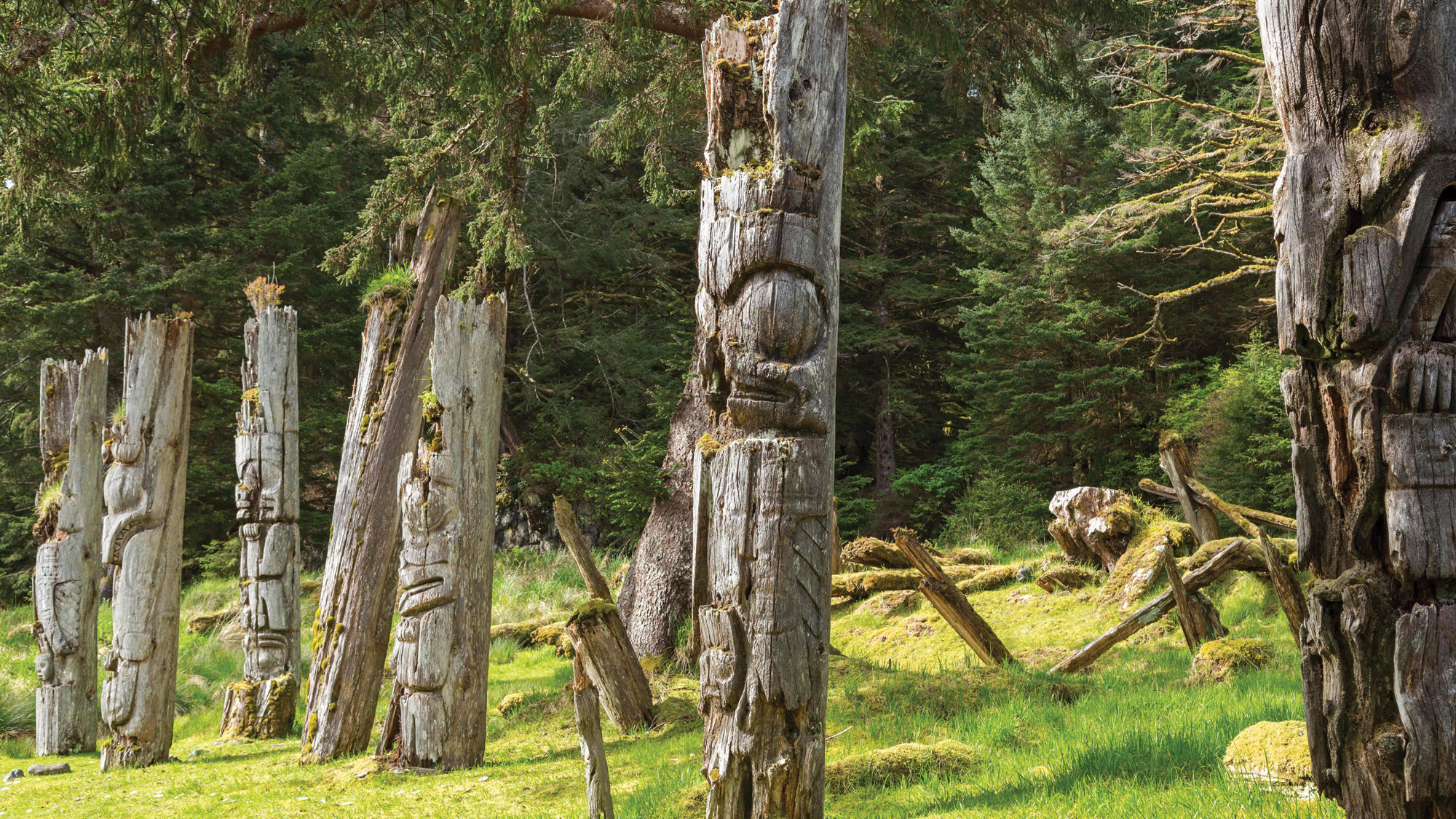
SKang Gwaay consists of a larger island and 27 islets and is an incredibly important seabird nesting area. SGang Gwaay Linagaay (Wailing Island Town) is in a sheltered bay on the east side. It is one of the best examples in the world of a traditional NW Coast First Nations Village site with habitation caves, middens, upright and fallen poles, house pits, standing poles and beams of longhouses. Chief Koya of the Eagle clan had a 6-beam house, a type of construction unique to the Haida. Ocean Roamer, another tour boat, arrived after us.
Why did the Khunghits die out while the Skidegate and Massets survived? With a smaller population, Chief Koyah made war on everyone. He once attacked a trading ship, the battle backfired, and 40 Haida died. To live down his shame, he attacked 3 more ships, taking two but losing many lives in the process. The Khunghits were also 250 km closer to Victoria than the Massets, and thus the vices of alcohol and prostitution were more available. The Massets traded with the Hudson’s Bay Company in Fort Simpson, which did not sell alcohol.
The beginning of the end came in 1862 when a ship from San Francisco brought smallpox to Victoria. The government tried to send the natives home from their camps, but by the time they left, all the camps of natives throughout the west coast of BC were infected, dying on the beaches along the way and taking smallpox with them. If that weren’t enough, an infected white man was put ashore at Skincuttle Inlet at a copper mine the same year.
In 1840, Skang Gwaii had 20 long houses and about 308 residents, but by 1863, smallpox had its root and ravaged the community. By 1884, there were only 30 people, 20 houses, 25 carved poles and 20 burial totems. In SKang Gwaay’s final years of occupation, after people consolidated from other villages, there were 20 longhouses and many poles. Everyone eventually moved to the two towns on Graham Island. The desertion of SKang Gwaii had one spectacular benefit: no missionaries were here to make the Kunghit destroy their poles.
In 1911, several burial poles were removed that ended up in Chicago and New York. Later, a fire burned part of the village. In 1940, five frontal totems were taken to Prince Rupert. In 1957, UBC removed parts of 11 poles. All the memorial and house frontal poles were removed in the 50s and placed in museums, and now only mortuary poles remain, of which there are more here than anywhere else in the world. It was declared a UNESCO World Heritage Site in 1981.
In that first trading interaction in 1787, Captain George Dixon bought 300 sea otter pelts at the cost of one chisel for every skin. The sea otter trade triggered a huge increase in house building, pole raising, art, and the carving of wood and slate. After at least 10,000 otter pelts were traded, they were extinct. Within a hundred years, resource grabs, disease, alcohol, and religion brought the indigenous culture and economy to ruins. Smallpox, influenza, measles and tuberculosis had reduced the number of Haida to 600 – over 90% were dead. Otter and caribou were extinct, whales were badly overhunted, salmon and cod were overfished, and old-growth forests were disappearing. Of the 50 or 60 major villages, only four – two in Haida Gwaii (Skidegate and Old Masset) and two newer settlements in Alaska remained.
We signed the guest book at the Watchman house and walked through the village site again, unaccompanied this time – magical for me.
We launched 30 minutes after low tide into swell and wind waves, and then calm water past Cape Fanny for the paddle with the current into Rose Harbour. This was a busy whaling station from 1909 to WWII, employing 150 men. In 1978, a group of 13 young island residents purchased the property and built imaginative homes among the whaling stations’ brick and metal ruins. Conflict was inevitable between Parks and the only private land owners in Gwaii Haanas, although Parks concedes that it is helpful to have some human presence in the southern part of the park.

I was keen to talk to Gotz and see where in his house he had placed the photographs I had mailed him 16 years previously. As it turns out, Gotz has a huge overflow of pictures of everything, especially of himself. On the other hand, Susan never receives pictures of her.
He has no room on his walls for pictures and doesn’t have any memory of my pictures! He was very appreciative of the pictures he didn’t remember. He offers up to 18 beds in his guesthouse and house, and Susan supplies all the food, most of it out of her garden. Along with tours and other boat work, they have to make money in the short tourist season. He had just rescued the mammoth plate steel Rose Harbour Whaling Co. sign and hoped to display it. A carved canoe was discovered several years ago near the trail to Gotz’s water line. Covered completely with moss, Gotz had walked by it many times until it was discovered by a tourist.
After leaving, it was a quick trip with the current to the SE corner of Moresby, where we ran into a north wind we fought to the south side of Benjamin Point, where we set up camp. The only camping here is on the beach – the forest is full of long clumping grass. I walked over to the north side of Benjamin Point and checked out the many camping possibilities there. A portage would be long but not impossible if one starts on the east side of our beach.
Day 8 distance: 35 km.
Day 9. Up at 4, and paddling at 5:30, we had finally mastered 90-minute starts. There was a big NE swell coming off Hecate Strait and a 10-knot north wind producing severe chop and very confused paddling. We paddled to the lee of West Rankine Island and leaving the protection of land, we were soon in white caps and a stiff northerly wind. After checking the charts, we decided to make for Samuel Rocks, 3 km down Carpenter Bay from Iron Point. We landed on the rocky east end of the beach, had lunch, and went back out in the afternoon to try again. The wind was blowing harder, and we returned to Samuel Rocks – this time to the west end with the best camping just past the creek, and had an early day. This was one of the most beautiful campsites on our tour. There was room for many tents and an easy landing at all tides. We thought we could make the ferry on June 14th, but that would be a real race.
Day 9 distance: 18km.
Day 10. At 5:30, the paddling was in calm fog with visibility of about one kilometre and a ceiling of 200 feet. Two black bears were turning over rocks on Burnaby Island just before the narrows. We entered Burnaby Narrows at 11:20 with low at 11:00. It had just turned to flood. Low tide was at 3.9’, so there was little to see.
The customers of Island Roamer were walking on the shore and kayaking outside the narrows. The wind started to blow from the north just as we entered Burnaby Strait. Progress slowed, and we finally dragged our bodies out of our boats back at Newberry Cove on Juan Perez Strait at 3:30. This was homecoming next to our gurgling creek. We had been paddling virtually nonstop for 10 hours without leaving the boat. It’s surprising how much energy is required to paddle into the wind for 3 hours. On landing, we both chorused how tired we were. If we were to catch the ferry on the 14th, we would have had to get well past here. We still haven’t given up on the prospect but it is now the 11:00 AM ferry on Monday, June 17th, that seems most likely. I hoped it would also give us a chance to see the museum that we missed on our arrival.
The sun was out. As the tide was rising, I emptied my kayak and moved it up the beach before I finally ate my lunch on the beach at 4:00 PM. We both eagerly called it a day. Day 10 distance: 46 km.
Day 11. Off at 5:30, the ceiling was at treetop level, reducing everything to the same scrunched-down height. This is the iconic Charlotte’s experience. Under perfectly calm conditions, it was fast paddling up Juan Perez Sound, Darwin Sound, around Richardson Island and into Logan Inlet, just inside the park boundary.
We had crossed to the Lyell Island side at Darwin Point. It was interesting to cross at least 4 current streams, evidenced by the fine ripple in the mirror-like water, the palpable effect of current on the boat and the change in speed from the GPS.
We got out of the boats for lunch near the Topping Islands. A small plane flew invisibly above the clouds and then came under the clouds to cruise down Logan Inlet. I mention all these interactions with the outside world, as there were so few of them.
As soon as we entered Logan Inlet, we were paddling into a light easterly wind. We had previously decided to camp at Gold Point on Tanu Island if we could not get to Skedans, so at 4 PM we pulled up onto the gravel beach. There were very few campsites.
Day 11 distance: 50 km.
Our favourite bird became the pigeon guillemots. With their white wing marks and red legs and feet, they are easy to recognize. They also have the most interesting behaviours. Instead of flying away when we approach, they often run clumsily across the water for long distances. When flying, their short wings beat at a high rate. Landing is hilarious – their feet don’t do much, they land on their chest and do an immediate face dunk.
Day 12. We have slowed down the pace, were getting up an hour later and having a relaxed breakfast. I was excited at the prospect of seeing our last Watchman Site at Skedans (“On the edge town”) and to finish going on the outside of all the islands on the east side of Moresby (except Burnaby and Ramsey).
Immediately after rounding the Tangil Peninsula and crossing the park boundary, we passed Helmet Island with its white-stained seal haul out. The whole eastern sky was in bright sun while we were covered with dark clouds. All the outside islands were perfect silhouettes.
The narrow gap between Vertical Point and one of the Limestone Islands served as a gun sight target. Vertical Point with its vertical folds eroded into fins and the imposing cliffs on the west side of the Limestone Islands were the best scenery in the entire trip. Vertical Point was once a Haida village site and also a home for hand loggers during the Depression who left a legacy of apple, honeysuckle, and rose trees.
We now left the proper charts and go to the minimalist photocopy from the camping guide. I misread them and we headed into Skedans Bay to visit the village of Skedans. I radioed the Watchmen, saying we were in the bay and looking at two big rocks and we got the reply. “Come into South Beach”. We get blocked at low tide, paddle around the two islands and land at a gravel bank in the bay. We walked over gravel bars and waded the creek and finally radioed the Watchmen again and asked where they were. After a while, they figure out we are in the bay and the village is at Skedans Point, about 4 km away!! We eventually landed on the south beach at Skedans Point and were greeted by David, a young Haida man here with his auntie. He invited us for lunch. We had the abbreviated tour of the village site with its many longhouses, one memorial pole, and about 9 mortuary poles, the second most anywhere. Some of the poles have detailed carvings.
In the 1830s, there were 27 longhouses here set like a necklace following the contour of the shore and 471 inhabitants with a peak of 700. The village had 56 carved monuments at the height of its fortunes. There were 20 Raven houses on the east side and 7 Eagle houses on the west. Lunch was delicious soup, grilled cheese sandwiches on homemade bread and tea. They were very gracious hosts.
At 1:30 PM, we launched into a SE wind and steep waves. We made it around the point, avoided all the rocks and got a great following wind and sea across Cumshewa Inlet. Speed averaged 8.5km/hr. Looking for a campsite, we landed at McCoy Cove but could find no visible camping. Our small-scale map wasn’t helping when we got out at what we think is McLellan Island. The island is connected by a gravel bar at low tide to the mainland. We camped in big, clear areas in large trees.
Day 12 distance: 38 km.
After dinner, I noticed next to my tent several moss-covered logs lined up like a Haida longhouse. Looking a little closer, I found all four corner posts and the hole for the house’s frontal pole. I decided to explore around, crossed the small creek to the west and encountered an entire village built on terraces. There were a few longhouses and amazingly (as it was stressed that only SKang Gwaii and Skedans had standing poles), three standing poles – a big memorial pole with many potlatch rings and two mortuary poles. The carving was detailed and distinct on two of the poles. One pole was intricately split in two by a tree growing directly up the middle. I continued west down the path and came to the large Watchman’s house. We had inadvertently camped at Cumshewa. The setting is lovely with a small rock ‘peninsula’. I wandered back through the lower bench in the trees and passed some huge boards stuck at odd angles, and obvious house sites but no beams.
When the missionaries came in 1905 to implore the last remaining Haida to leave, about 300 people were living here in 20 houses. It was inhabited by three closely related Eagle lineages, the exception being a Raven lineage in house 13.
The Cumshewa were the fiercest of the Haida. In 1794, they captured the schooner ‘Resolution’, executed 10 of the 11 crew and sold the remaining man as a slave. In 1796, ’98, and ’99, they attacked three more trading boats, and as late as 1855, they were the foremost raiders and traders of slaves. It is estimated that 30% of the native population were slaves. The distinctive head deformation practices of different tribes made the identification of the origin of different slaves possible.
Day 13. No rush today, a light 25 km paddle west to Moresby Camp, where we planned on camping. We hopped over to Haana Islet at Cumshewa and walked all over the attractive place, thinking it would be a natural place for a longhouse. It was a burial ground and held a fort at one time. We paddled into a light westerly past the real McLellan Island to Conglomerate Point with its imposing face of cemented gravel and rock. After this, the wind died for the rest of the way, and we arrived at Moresby Camp at 3 PM. In bright sunshine, we dried out everything and complained that it was too hot.
Day 13 distance: 25 km.
The rest of the trip. The next day we caught the ferry back to Skidegate, the museum was closed as it was a Sunday, and we had all day to do not much. We camped, caught the 11 AM ferry to Prince Rupert, and drove continuously via the Duffy Lake Road to Horseshoe Bay and home in Courtenay. We arrived by dinner time on Tuesday, June 18.
Summary: The entire trip, including all the driving, lasted 18 days, with 13 days spent kayaking. However, only 9 and a half days of actual paddling were completed, due to starting at 2 PM on our first day and taking 2 full and 2 half days off for weather conditions. Not many people would like to travel this way or kayak these distances.
The entire kayaking trip was 377 kilometres – 178 km from Moresby Camp, travelling on the inside of Louise and outside of Lyell Islands to SKang Gwaii, and 199 km from SKang Gwaii, travelling on the inside of Lyell and the outside of Louise Islands to return to Moresby Camp. Going both ways is the best way to understand Gwaii Haanas. Ironically, although this is the longest trip available in the park, it is also the most affordable, as no charter costs are involved.
We saw everything that we had wanted when first planning the trip. This included both the inside and outside of the entire route. We did paddle through Burnaby Narrows both up and down, but I imagine few kayakers go on the outside of Burnaby Island. We visited all five Haida Watchman Sites and also intimately saw Cumshewa. We experienced most kinds of weather and had some bad paddling conditions (Hecate Strait is not to be trifled with), but we had a lot of spectacular weather and paddling. We averaged 40 kilometres per day, excluding weather days. We set personal records when we paddled 60 km on day 7 of the trip. We had great food. Campsites felt like we were the first visitors. We experienced virtual solitude for 13 days. We could have seen more whales. It didn’t rain every day. It was perfect.
The removal of poles from Skidegate harbour dramatically changed the landscape between 1884 and 1895. In just over a decade, the lion’s share was gone. Some poles on the BC coast were seized in outright theft. Others were gathered by anthropologists and collectors who negotiated with Indigenous communities.

