
Bolivia Feb 4- 29/2012
Bolivia is the 5th biggest SA country – about the size of France and Spain combined. Of the 9.8 million people, 60% are indigenous giving it the highest proportion of all SA countries. 70% of the total population live in the frigid Altiplano region (elevation 3500 – 4000m; an immense treeless plain) which lies between 2 arms of the Andes. More than half of the country is in the Amazon basin and the northern and eastern lowlands are sparsely populated and flat, with swamps, savannas, scrub and rain forest. Landlocked, it is the highest, most isolated and rugged nation in SA. Despite being the richest in natural resources, it is the poorest. The standard of living is alarmingly low. After nearly 200 changes of government in its 182 years as a republic, it presently seems stable with its first indigenous president who has pushed through unprecedented reforms for the indigenous majority. He ceased the US sponsored coca crop eradication program by kicking out the DEA in 2008. Coca has always been part of Bolivian culture as chewing the leaf reduces hunger, cold, and pain and increases alertness but is not addicting (it was part of the original Coca Cola recipe). His motto is coca – yes, cocaine – no (cocaine is only one of the 14 alkaloids in coca).
Crossing the border were hundreds of others but there were no problems or fees. Copacabana (pop 55,000), on the south shore of Lake Titicaca is a pleasant place packed with mostly young tourists. At 3800m, the days are pleasant and sunny with rain in the afternoons and evenings. The nice Moorish style cathedral has blue Portuguese style ceramic tiles. The same festival in Puno is also held here. The highlight here is Isla del Sol, a large island in Lake Titicaca. It is the legendary Inca creation site. My plan was to take a boat to the north end of the island and walk 4 hours visiting several archaeological sites but because of ¨protests¨, the trip went to Isla de Luna with one ruin and the south end of Isla del Sol again with minor ruins.

The next day I took a 6 hour bus crossing Lake Titicaca on a ferry, to La Paz (pop 1.2 million, elevation 3660m), the capital of Bolivia. The approach is beautiful as the city is located in a steep walled valley and its buildings climb spectacularly upward, with Mt. Illamani (6402m) in the background. Indigenous women in bowler hats sell everything on the streets. It is cold and I am thankful for my down puff jacket. Despite all the traffic, it is a great city to wander around. The first day I visited the 4 small municipal Callen Jaen museums (only the gold and silver museum was truly worthwhile), Plaza Murilla, a couple of big churches and completed a lot of business including booking several trips for the next 10 days. All the shoeshine boys in La Paz wear balaclavas, completely disguising themselves as they are apparently embarrassed by their chosen career. On my second day I bicycled ¨The Most Dangerous Road in the World¨, a 63 km road that descends from 4600m to 1200m. Before 5 years ago, when a new paved road was built to bypass this road, the moniker was justly deserved, with 63 bicyclists dying in the last 15 years. Now, with little traffic, few people die. Death is usually from going over the edge with precipitous, huge drops into the canyon below. Starting in the high alpine at a pass, the first bit is a fun 31 km fast cruise down the highway, and the second part is on rough gravel passing through a few waterfalls. It is a very dramatic scene. This is a not-to-be-missed trip, and everyone gets a t-shirt.


The next day, I went to the only significant archaeological site in Bolivia, at Tiwanaku. Inhabited from 1500 BC to 1200 AD, the site is heavily restored and not that special, especially after all the great ruins in Peru.
As this is one of my last opportunities to do jungle and booked two tours out of Rurrenabaque (pop 15,000, elevation 105m) NE of La Paz. Up at 4 to catch the 35-minute flight at 6:15 (the only other way here is a rough 20-hour trip), it was different to arrive in the humid heat (felt like 40 degrees and 100% humidity). My first 3 day tour was to NP Maddidi, and we took a 3-hour boat trip up the Beni and Tuichi Rivers to the jungle camp. True to the common experience at this time of the year, it was a lot of mud with few critters – we saw two capybaras (the largest rodent in the world), a troop of yellow monkeys, and best of all, a herd of about 100 peccaries (wild pigs) running very close through the woods. They snort a lot, and we were close enough to be able to smell them. A night walk saw a lot of great insects and spiders. There were some very big trees but the non-English speaking guide seemed much more interested in the herbal and medicinal uses of every plant (which, after a while, seems like a lot of hogwash to me).
After an overnight in ‘Runne’, we had a long 3 hour drive to the start of the Pampas trip. Dry savanna the rest of the year, this completely flat area is one big lake in the rainy season. We boated up the Yacuma River (it all seemed like a gigantic maze with water everywhere) for an hour to the camp built on stilts with elevated walkways connecting everything. There were alligators, many pink dolphins, 3 kinds of monkeys and lots of birds. Looking for anaconda in the wet season is a waste of time and the guides had not seen one for a month. Swimming with dolphins did not work well as they were not too interested in us (but they bit the foot of one guy) and the piranha didn’t bite when fishing. A night trip to see alligators (or at least their eyes) was amazing as the guides had no trouble knowing where they were. However despite the failure of all their ¨tours¨ and lots of rain, it was lovely boating all over the place with flowers, many birds, and nice scenery. One of the guides, a local native, had an amazing ability with language. Because of all the Israelis that do the Pampas trip, he spoke perfect Hebrew with all the slang. Like most tours, everyone was under 30. Most were Europeans, many in Bolivia volunteering or going to university on exchanges.
With a day off in La Paz, I visited the outside of the San Pedro Prison, the subject of the book, ‘Marching Powder’. A very unusual jail, the inmates purchase their own apartments, families live in the jail with their inmate husbands, and it was the best source of cocaine in Bolivia. The main character in the book becomes a tour guide but the tours are no longer available. The front gate had a lineup of women waiting to get in but the guards were not too tolerant of me trying to look though the front entrance into the courtyard full of nasty characters.
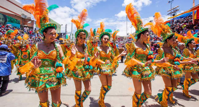
I caught a 4 AM tour bus to go to Oruro (pop 260,000), a city 3 hours south of La Paz to go to the most famous Carnival in Bolivia. The parade started at 9 and didn’t stop till 3 AM, although I finally walked back to the hotel at 10:30. It was an incredible day, and I can’t believe there is a better carnival anywhere. Basically, there are 11 folk dances, and each group showcases one, each with its own history, costume style and step. Each group tries to outdo the others with the costumes and garish masks, and consists of older women in traditional dress, young women with skimpy outfits, young male dancers and then a band. The quality and expense of all the dresses were astounding; for example, all the band members wore nice suits. Grandstands lined the main street for blocks, and the audience really gets into it while consuming prodigious amounts of alcohol. Thinking I wouldn’t enjoy it after we were given our carnival bag with a plastic poncho and a can of spray foam, I ended up buying 4 more cans of foam. It was great fun.
A 10-hour bus ride the next day took me south to Sucre (pop 215,000), a Unesco Cultural Heritage site, with its rich colonial heritage. Their version of carnival consisted of a few bands walking around the square, a lot of drinking, and huge water balloon fights. The most interesting tours were cancelled as they entailed crossing a river that was too deep in the rainy season. All the museums were closed as Monday and Tuesday were holidays, so I caught a bus back to Potosi (pop 150,000). At 4070 m, this is the highest city in the world. Its silver mines were the world’s most lucrative, and it was the largest and wealthiest city in Latin America in the 1800’s, underwriting the Spanish economy for over 2 centuries (that is a lot of mosts, but many claim it was the wealthiest city in the world). It is estimated that 8 million indigenous and imported black slaves died in the mines in appalling working conditions!
As Feb. 20th and 21st were national holidays, all tours and buses are cancelled so I had a nice day off. With it being very cold and rainy here, I spent most of the day reading and playing cards with a bunch of young Chileans. I taught them 2 new games – Yaniv and Asshole, both very popular travellers card games (if anyone wants the rules, go to Traveller’s Card Games on the Travel Page).
The highlight of Potosi is a tour of the mines. Of the original 600 mines on Cerro Rico, the big mountain that looms above town, about 150 are still working, employing 15,000 people – still a backbreaking, dangerous and unhealthy job. After suiting up in supplied pants, jacket, gumboots, and a helmet with a light, we went to the miners’ market to buy dynamite and drinks as presents for the miners. I never could have imagined that the mines were what they were. Half the time, the ceiling was high enough to allow normal walking, ⅓ was spent in shafts that required significant bending over and the rest was spent crawling on hands and knees or slithering along on your belly. The down shafts connecting the 3 levels we explored were narrow tunnels through rough rock. The roof supports of eucalyptus logs, when present, were haphazard, and many logs were snapped in two – all conditions that would be unacceptable in first-world mines. With temperatures of 40 degrees, it was a hot, exhausting experience that I was all too happy to end. The life expectancy of the miners is 55, and they die from rock collapses, toxic gas exposure and silicosis.

That afternoon, I visited the Museo Casa de Moneda (the coin mint that once supplied the entire Spanish empire, closing in 1951) and the beautifully restored Convento de Santa Theresa (which admitted only the daughters of wealthy families and is still a cloistered Carmelite order).
A 6-hour bus ride south through hilly terrain covered in thorn trees and cactus (cross between saguaro and organ pipe) brought me to Tupiza (pop 23,000, elevation 3200 m) in the southwest corner of Bolivia. It is about 40 km south of Huaca Hualusca, where Butch Cassidy and the Sundance Kid robbed the Aramayo payroll before meeting their maker in the small mining village of San Vicente in 1908. I stayed in the excellent Hotel Mitru ($9/night) with a swimming pool, truly hot showers, and with the only included breakfast with more than bad white buns, jam, and coffee (eggs, cereal, and really crusty buns!). The only restaurants in town are Italian, and pizza is the main food. Despite not riding for many years, I went on a 5-hour horse ride through a spectacular country most reminiscent of the red rock area around Sedona, Arizona. There were fantastically eroded columns, fins, arches, and hoodoos in the 2 canyons we rode through. After a few tips from a Dutch girl, I actually enjoyed the ride and didn’t have a sore ass after.

The biggest attraction in Bolivia, and thus a major stop on the gringo circuit, is the Uyuni Salt Flats, at 12,108 square km, the largest salt flat in the world. With 11 layers of salt and water, it is 2-20 m thick and contains the most energetic minerals in the world – lithium, magnesium, sulphur, potassium, nitrogen, phosphorus, and borax. Bolivia owns 50% and Chili 40% of the world’s lithium, all contained in these large salt flats. With many ways to do it, I decided to do the 4 day/3 night tour from Tupiza. It is a 1200 km 4WD drive through SW Bolivia, all on dirt and gravel roads. There were 13 of us in 3 Toyota Land Cruisers, making for comfortable driving – 3 Germans, 2 each from England, Argentina, and France, and one each from Hong Kong, Spain, Denmark and Canada. All were 30 or under.
Day 1. Our first stop was at the Valley of the Moon with marvellous erosional features similar to Bryce Canyon.
The road was very dodgy with washouts, huge mud holes, and no bridges over the many streams and river crossings. It was much more about the road than the scenery initially as the road passed through high, treeless Altiplano, low hills, and some snow-covered mountains in the distance. We got stuck twice, requiring short tows. It was below freezing at night. There were many herds of llamas (all domesticated and raised for their meat) and many vicuñas (all wild).
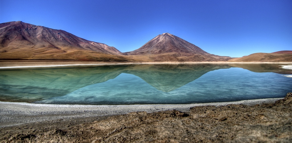
Day 2. On the second day, we crossed a pass at 4855m and reached the point where Argentina, Chili, and Bolivia meet at a high green lake (coloured by arsenic and magnesium) under a big volcano.
We turned north, passing through high desert with no plant life, spending most of the time between 4600 and 5000 m – a few were altitude sick. The views were of big skies and scattered snow-covered mountains (not the Andes). We passed the Dali Desert (a bleak white slope with small rock outcrops), a geyser field (only very active fumaroles), unusual eroded sandstone formations and many high lakes, some with thousands of pink Andean flamingos.

The lakes are dry in the dry season when all the flamingos migrate to Chile.
Day 3. On the third day, through the desert, we had a nice soak in a hot spring at 5000 m on the edge of a lake before reaching Uyuni (pop 20,000), one of the butt assed ugliest towns in the world. The next day, we were driving at 5 AM to go to the salt flat to see the sunrise. It was a slow drive (to avoid splashing water up into the electronics of the truck) across the flat covered with a few centimetres of water (completely dry in the dry season) to the Salt Hotel, built entirely of salt in the middle of the flat.
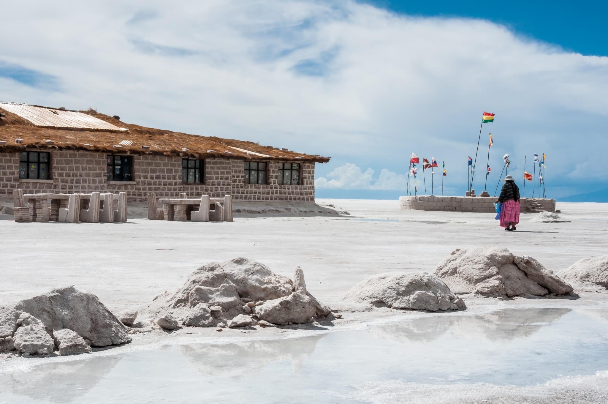
The water presents a perfect mirror with a limitless horizon punctuated by many intermittent snow-capped mountains ringing the flats. They seemed to rise directly out of the water despite often being some distance from the lake. It was extremely beautiful and many say this is one of the highlights of South America. The group spent 3 hours playing photographic games using wide-angle perspectives.

Returning to Uyuni, I left with the 3 Germans to go to San Pedro de Atacama in Chile over the next 2 days. It was a 4WD trip retracing part of the 2nd and 3rd days of the last trip, eventually crossing a high pass in the Andes. When we passed the hot springs at 7 AM, there were 14 Land Cruisers on the side of the road and all their passengers were enjoying the springs.
Cost of Bolivia: 24 days – $1523.70 = $62.69/day

Hi all, I ran across your internet-site through Google when researching an equivalent matter, your internet site came right up, it looks beneficial. I’ve truly included in favourites|combined with my own book marking.
helpful! i love reading your articles, thanks for all. lista de email lista de email lista de email lista de email lista de email