
Peru Dec 27-Feb 4/2012
Peru is large (about 5 times the size of the UK) and has a population of 30 million. Like Ecuador, it has 3 distinct regions – a narrow coastal strip that is mostly desert (10%), the Andes that rise to over 6,000m just 100 km inland (30%) (the eastern Andes gets much more rain than the west side), and the Amazon Basin with jungle (60%). Half the people are below the poverty line and many seem to work as street vendors selling anything. Like most third world countries, there is a huge gap between rich and poor. 45 percent are purely indigenous and most of these live in the Andean highlands. As in most SA countries, and unlike the rest of the world, the Catholic churches are well attended. Peru has been characterized by coups and repeated military dictatorships during much of the 20th century. At one point in the 1980`s, inflation reached 10,000 percent! With mammoth deserts, glaciated mountains, tropical rain forests, and almost every imaginable habitat in between, Peru hosts a menagerie of wildlife. Deforestation is as big a problem here as in the countries already traveled in, and mining has caused significant pollution. The potato (Peru boasts 4000 varieties) was domesticated in about 3000 BC. Gas is close to Canadian prices at $4.80 per US gallon. One of the favorite foods is cuy or roast guinea pig. Everyone seems to chew coca leaves. The drug is best absorbed if taken with some alkali and gives energy, decreases appetite and is not addictive like cocaine. Coca leaf tea is drunk by everyone. The presidential election was held in 2011 and the names of presidential candidates are painted on every available wall (especially Keiko – the daughter of past president Fujimori who is now in jail for corruption and murder – she came third). 2.7 nuevo soles to the US$.
The Inca lasted from the 12th to the 15th centuries, but were only preeminent in the last 100 years due to the conquests of the 9th Inca emperor who extended the empire from the Ecuador- Colombia border to northern Chile. Decimated by smallpox, overextended by conquest and civil war (the 12th emperor split the kingdom in two, giving one part to each of his two sons, and they went to war with each other), and helped by other indigenous groups, the 13th Inca emperor was easily defeated by Pizarro in 1532. Diseases like smallpox had preceded Pizarro and affected the population. Lima, the capital of Peru, on the central coast, was founded in 1535. There were many great civilizations extending back to at least 1000 BC prior to and defeated by the Inca, especially along the northern coast.
The 12 hour bus ride to Piura, Peru from Cuenca passed through initially dry mountains, then coastal desert. The border crossing is confusing as the immigration offices are separated by 5kms. After being quoted 2.6 soles per US $, the guy multiplied by 2.06! Only trees in the dry riverbeds have leaves and the dirt had only scrub trees for vegetation. Where irrigation is available, huge fields of banana, sugar cane and the main crop, rice appear. Many trucks haul large black bags of rice. I bypassed Mancora, Peru`s major beach resort, little more than a glorified surfing village. There were many oil wells along the road. Arriving at 7 PM in Piura, I decided to continue on the bus for 3 hours to Chiclayo (pop. 740,000), my first stop to visit its many thrilling archaeological sites. Some of the obvious differences in Peru were the large amount of garbage on the roadsides (just like most of Central America but not so far in SA), every clothing store is packed with mannequins displaying clothing, motorcycle taxis and Daewoo cars for taxis, no indigenous people on the N coast, great buses and roads, and many more street vendors.
I took an excellent tour my first day to visit 3 sites. 40 km north is Tucume with its vast complex of crumbling walls, plazas and 36 pyramids. As there is little rock here, everything was made of adobe (mud-straw bricks) and the pyramids now look like severely eroded hillsides, as rain over the centuries has simply melted away the adobe.
In Lambayeque, a few km north of Chiclayo, the Museo Tumbas Reales de Sipan, is a world-class facility showcasing the Royal Tombs of Sipan, of the Moche culture that flourished on the northern Peruvian coast from about 100-900 AD. This is one of the most important archaeological findings in the Western Hemisphere. The elaborate tomb, gold, and jewelry of the Lord of Sipan, his head priest and many poisoned companions were exquisite and ably showcased in the superb museum. The pottery is very good.
We then visited the original archaeological dig 35 km SE of Chiclayo where replicas of the original gold-smothered Moche burial site have been replaced exactly as discovered in 1987 and 2007. The next day, a similar (but not nearly as good) tour went to Ferreñafe, 18 km north of Chiclayo, to the Museo Sican, showcasing the burial findings of the Sican culture which followed the Moche people. The Lord of Sican was buried upside down and decapitated. They also built now disintegrating pyramids of adobe.
My crappy Spanish showed the next day as I got up early to catch the long bus to Chichapoyas, east of Chiclaya in the highlands of the Andes. After waiting several hours, I found out that the bus wasn’t leaving till 8:30 PM (so am spending as long as I can updating this email – again this is my travel diary and I work on it most days). To give you an idea of prices in Peru, I will recap my first day off with no sightseeing: 5 hrs of internet – $2, an excellent lunch of chicken, rice, french fries and water – $4.25, haircut (trim neck, ears and shortening) – $2, Starbucks venti mocha $4.25, movie (Mission Impossible 4 in English) – $4.25, popcorn $3.25. I then took the luxury bus with completely reclining, wide seats and food service for 11 hours to Chachapoyas (pop. 23,000), having a great sleep on the way. The drive at the end followed a fast-flowing river through a gorgeous canyon. Arriving at 8 AM in the town square, I arranged 2 days of tours ($20 each), got a hotel room and had breakfast to start the first tour to Keulap at 8:30.
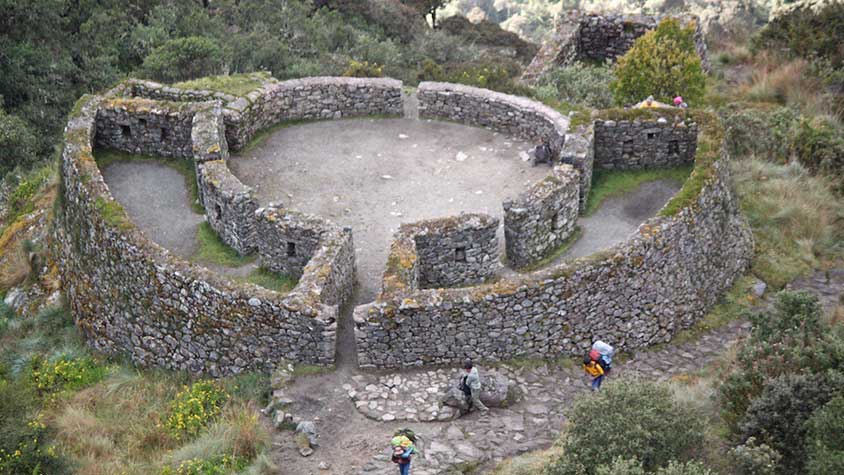
Kuelap supposedly rivals Machu Picchu. Located 73 km from Chachapoyas, it straddles a high ridge visible for miles around. Built in the 6th to the 12th centuries by the Chachapoyas people, it is 580 x 120 m in size, with 19 m high magnificent stone walls enclosing its 7 hectares. It has towers, 500 round stone houses, and a large inverted cone ceremonial stone structure. It was captured by the Inca in 1470 and rediscovered in 1853 and has been minimally excavated.

I spent a quiet New Year and the next day took a tour to Gocta, the 16th highest waterfall in the world at 771 m. It has two drops, the first of 237m and a second of 520 m. After a great 5 km hike to the bottom of the falls, one gets completely soaked in the huge spray as there is a lot of water in the falls. The surrounding scenery was magnificent with limestone cliffs on the steep mountainsides.
South American women are not in great shape and the last arrived back at the trailhead 3 hours after me. They may look attractive with their dark skin and gorgeous thick black hair, but are helped by padded, push-up bras, and very tight clothing. Most are overweight with paunches.
After an overnight 11-hour bus ride back to Chiclayo followed immediately by another 6-hour one (the last through the flat desert, some irrigated, and then very dry rough, rocky mountains covered in cactus, scrub, and yucca), I arrived in Cajamarca (pop 165,000). At an altitude of 2770 m, it lies just east of the continental divide, draining into the Atlantic. Most of the indigenous people wear huge white cowboy hats with tall tops. The local delicacy is fried cow brains. Riot police were all over expecting trouble from a protest over a proposed gold mine out of town. The third largest gold mine in the world is near. Few locals are employed there, prices are inflated for everyone and pollution is significant. They do not want another mine. I took a great tour to Cumbe Mayo, an amazing place with an aqueduct built around 1000 BC. At 3700 m, it is just below the west side of the continental divide. The area has incredible eroded volcanic formations all over the place. A ceremonial sanctuary with many petroglyphs to their god – thunder, representing rain, was carved out of the volcanic rock. Below they built a .8 km aqueduct carved out of the rock to divert water meant to flow to the Pacific and now carrying the water east another 9 km down to Cajamarca. The sides were carved perfectly straight and involved tunnels, a small dam, a diversion system, a bridge crossing over the natural stream, and a system to slow the flow of water. Cajamarca was captured by the Inca in 1456 and the aqueduct was not used again.
The prison holding the last Inca emperor, Atahualpa, just before he was killed by Pizarro (after he had paid a ransom consisting of a whole room of gold and treasure), is the only Inca building left in Cajamarca. A second tour went to the Ventanilas (windows) de Otuzco. After being buried for several years, the bones were disinterred and buried in intricately carved holes in a volcanic cliff side.

Most reforestation (as in Spain) is done with eucalyptus as it tolerates dry conditions, grows fast and straight and is thus good for lumber.
Almost all long-distance buses travel only overnight and the luxury bus left at 10:30 PM (despite the disadvantage of not seeing the countryside one drive through, you save the hotel room which often equals the price of the bus ride) for the 6-hour ride to Trujillo (pop 748,000) on the coast. Founded in 1532 and named by Pizarro after his hometown in Spain, it is the center of many archaeological sights as it was ground zero for some great civilizations prior to the Inca and Spanish. I spent 3 days going to a different site each day.
The best was the Huaca (temple) de la Luna built by the Moche (100 – 900 AD). Every 80-100 years coinciding with very wet (and bad for them) El Nino years, a new layer was added to these monster adobe pyramids completely covering the previous layer. The interior walls of each layer were covered with repetitious intricate coloured friezes of their god and the 5 huge levels on the outside each had different painted carvings (1st- the warriors with the loser being sacrificed hopefully to prevent wet years, 2nd- the priests, 3rd- serpents etc) all wonderfully painted. The associated museum had great info and expertly done pots.

Chan Chan, built in about 1300 AD, by the Chimu people is huge and once formed the largest pre-Colombian city in the Americas and the largest adobe city in the world. Most of the 10,000 structures and 9 royal palaces have dissolved into crumbling mud walls but one palace has been restored. Ancestors were revered, their possessions were thought to be necessary for their afterlife, and each new leader started from scratch. The third site visited was El Brujo, where recent excavations of the large adobe pyramid discovered La Senora de Cao (300 AD), the female emperor of the Moche people was buried at age 25 after dying in childbirth. There were several gold crowns, 20 necklaces of all varieties and 25 spectacular silver and gold nosepieces. Her body was mummified using Cinnabon (mercuric sulphide) and unwrapping her took 6 months. Her body had multiple tattoos still visible today. There were huge sugar cane fields surrounding the desert area of the site on the ocean.

I then bused south to Huaraz (pop. 90,000), the Andean adventure capital of the Cordillera Blanco, the highest mountain range outside of the Himalayas. The high season for climbing is from May to September, and the rainy season (now) sees little activity. I took a day tour to Chauvin, the site of a people from 1300 to 800 BC. Highly stylized carvings on stelae and a pyramid with striking tunnels and a labyrinth are the highlights. Crossing a 4500 m pass, we drove through snow for 2 hours on the way back.
The next day I started the 47 km, 4-day Santa Cruz Trek through Huascaran NP: The drive to the beginning was worth the cost alone – huge sheer granite walls with waterfalls, turquoise alpine lakes, views of Huascaran (at 6750m the highest mountain in Peru) and over a 4600 m pass to begin the trek at Vaqueria on the Atlantic side of the divide. On the second day, we recrossed the divide at Punta Union, a pass at 4750 m and a lung-busting climb. The surrounding 6000+ m peaks all looked like the Matterhorn, with razor ridges and glaciers. One of the mountains passed was the ¨Paramount Pictures Mountain¨. The descent was down a spectacular valley with sheer granite walls, many waterfalls and a rushing creek. The guided trip supplied tents and sleeping bags, all food and 4 burros to carry everything (the company was Galixia and was very good; I have heard that Euroinca is terrible). This trip has become number 2 of my all-time favourites (after Torres del Paine NP in Patagonia).
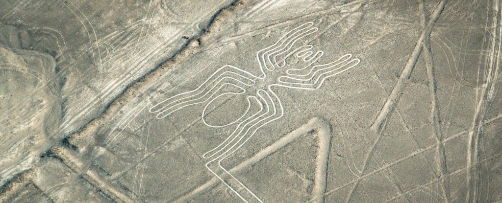
After a lovely dinner with 2 fellow trekkers from Denmark, I caught the 11 PM bus 7 hours to Lima and then the 7 AM bus another 7 hours to Nasca (pop 22,000). The terrain was an incredibly desolate, plantless, sandy desert along the coast. The two things I missed between Lima and Nasca were Isla Ballestas and Reserva Nacional de Pabacas (‘the poor man’s Galapagos’ with penguins, dolphins and sea birds) near Pisco, and Huacachina (an oasis with large sand dunes) near Ica. The Nasca Lines have been on my bucket list for years. Discovered first in 1927 and declared a Unesco World Heritage Site in 1991, they form a striking network of more than 800 lines, 300 geometric figures and some 70 animal and plant drawings spread over 500 square kilometres. The most elaborate designs include a whale, the astronaut, a monkey with an elaborate spiral tail, a dog, a condor, a spider, a hummingbird, a frigate bird, a spider, Alcatraz with a sinuous tail, a parrot, a tree, hands and a baby condor. The largest is 260 m long and can only be appreciated from the air. The 30-minute flight (cost $90 US) was quite spectacular as we got to see each figure from both sides of the small 4-seat Cessna plane. The lines were made by the Nasca Culture from about 400-650 AD by moving the dark iron stones to the side exposing the white lime dirt underneath. This leaves a hard surface that is resistant to rain (which virtually never falls here) and wind. Their significance is uncertain but is probably religiously related to water. It is doubtful that they have an astronomical meaning.
Chinchero (ancient church with a beautifully painted interior built on top of the original Inca fortress). I purchased a wonderful completely hand-made (washing, spinning, natural dyes, woven on a back loom by the indigenous people) baby alpaca table runner here even though I had no room in my pack ($200). The woman was so happy, she hugged me twice. The next day I took the bus 8 km north-east to Tambomachay (Inca aqueduct and ceremonial bath).
I then walked back to Cuzco visiting 3 more Inca sites – Pukapukara (hunting lodge), Q’engo (cave with carved altars), and Saqsaywaman (site of the last Spanish-Inca battle with its magnificent three-tiered fortress and many huge blocks forming the Inca walls. Many of the blocks were up to 60 tons). One can never see enough of the Inca walls. The stone blocks are intricately fitted together and are less commonly 4 sided pieces or more often polygonal in shape. The granite blocks are carved with bronze, copper and stone tools leaving perfectly fitting sides and a convex pillow shape on the outside. It is estimated that 1,800 men were needed to move some of the blocks that at Saqsaywaman weighed up to 90-120 tons. The workmanship is so perfect that it seems unlikely that it could be replicated today. The seams are so tight that nothing is growing in them now 600 years later. Several techniques were used to prevent earthquake damage – all doorways (no actual doors were used) and windows are trapezoidal and the base for all the walls was much smaller rocks. The walls also tended to be inclined. The success of these is evident today as there is virtually no seismic damage. The blocks fit so perfectly that they tended to settle back to their original position after earthquakes.


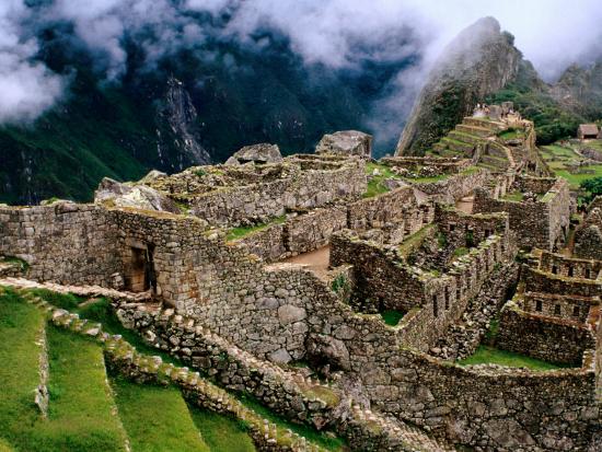
January 17th was my first day on the Inca Trail to Machu Picchu. One of the seven modern wonders of the world, probably the most important archaeological site in the western hemisphere, and a Unesco World Heritage Site since 1985, it is on everyone`s bucket list. It can be visited in many ways including by bus or train (the fastest, easiest and cheapest), or by several trekking routes.
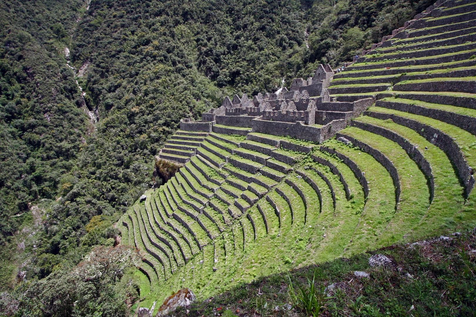
I opted for the Inca Trail, a 47 km walk following the original Inca route (80% original stone pavers) that is the hardest and most expensive way ($645) and is as much part of the experience as the actual ruins. At the time it was the only route to Machu Picchu. 500 permits are given per day for the Inca Trail and need to be booked weeks in advance especially in the busy dry season from May to September, but only 200 are for tourists, the other 300 are for the porters and guides. Up at 5 am to bus 3 hours to km 82 on the rail line (elevation 2380m), the trail followed the Urubamba River briefly before starting the climbing. Passing 3 Inca ruins, we camped at 3300m, in a steep walled valley. On day 2, we had a stiff climb over Dead Woman`s Pass, at 4200m, the highest part of the trail, a descent to 3600m, another ascent to 4000m and then a descent to 3600m again to camp. Day 3 saw another ascent to 4000m and then a steep knee-destroying descent to 3000m to Wuiñay Wuayna with its tremendous ruin often dubbed ¨little Machu Piccu¨. There were 50 terraces each supported by 5-8 foot stone walls, 14 fountains, many houses, and intricate stonework on the upper ruins.
The route goes through incredibly steep terrain and narrow valleys. The food was copious and almost gourmet in quality and most of us gained weight despite all the exercise. With 15 in our group (3 each from Canada, USA, Germany, England and Australia; the next oldest was 36), we had 2 guides, and 21 porters and kitchen staff. The porters carried the tents, food and cooking stuff. Only 2 of us did not hire an extra porter to carry the rest of our gear.
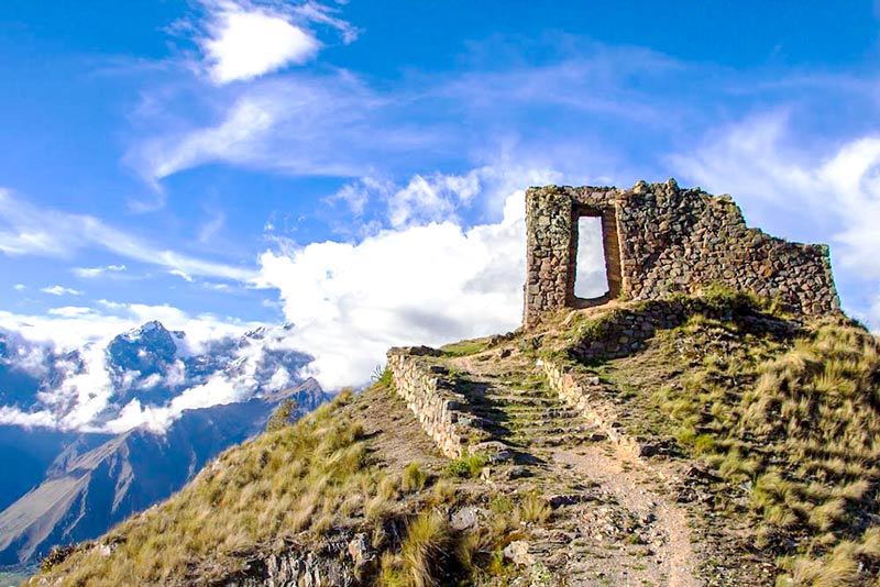
Day 4 saw us up at 3:45 to eat and hurry up and wait for the control point that opened at 5:30. An hours walk brought us to the Sun Gate high above MP, where we waited in the cloud and mist to see the first views of the ruins.

After walking down, we had our guided tour and wandered around the huge site with its many houses, temples, immaculate stonework, and terraces.
We then eventually took the bus down to Aqua Calientes where we had a great buffet lunch and a shower to stay the night in a hotel.
Day 5, I bussed back up to the ruins at 6:30 to spend some peaceful time and then climb Waynu Picchu, the mountain behind MP. It was straight up, took 35 minutes and I passed 46 youngsters before the top. MP was in cloud that repetitively opened and closed over the hour I was there. On the way down, I took the trail down the backside to visit the great caverns with ruins. It was then a long hike back up to regain the trail. I then revisited the entire site and evesdropped on many guided tours to try to gain more insights, especially as to how the stone was so intricately carved and polished to form the seamless joints (nobody has been able to answer this question). The view was stunning. The Inca Bridge, the only other original access to MP other than the Inca Trail, bridges a gap on a trail that crosses an entire cliff face. Most of the trail is now totally overgrown.
I then returned to Aqua Calientes on the bus, and then a train and a bus back to Cusco for a long, exhausting but spectacular day.
The next 3 days were spent visiting all the museums (the two best were the Inca Museo and the Precolumbian Art Museum) and churches in the city. I took a tour to the Salt mines at Maras (2 mines with natural springs produce brine that is intricately diverted to over 700 small rock-enclosed, clay-lined evaporative pools covering a terraced hillside).
The second site was Moray – several concentric terraces that served as an agricultural laboratory. Each terrace has its own microclimate with as much as a 5-degree difference from the next terrace where different varieties of coca, potatoes and beans were produced. That is how you get 4000 varieties of potatoes.

I had hoped to go to Manu NP, widely regarded as the most pristine jungle in the world and the best area to see tropical wildlife (cock of the rock birds, macaws and parrots at clay licks, giant otters, capybaras, caimans, jaguars and many kinds of monkeys) in South America. Unfortunately, the tour required 5 participants and it was cancelled as there were only 4. I have spent these last 4 days hanging out with a young South African woman who has been working as a tour guide in Namibia. It was great to have someone to spend time with.
AREQUIPA (pop 905,000)
After another 10-hour bus ride (but this one during the day through gorgeous high altitude, treeless mountains and valleys), I arrived at Arequipa, the second biggest city in Peru. With 3 large mountains as its immediate backdrop, it is in a majestic setting. Most of the city is built of sillar, a white volcanic stone quarried 18 km from town. Its main plaza is surrounded by beautiful sillar buildings including an enormous cathedral.
A highlight is the Museo Sanutarios Andinos which exhibits Juanita, the Ïce Princess¨. Discovered in 1995 at the top of Volcan Ampato above Arequipa, she is one of several adolescent Inca girls raised since birth for sacrifice on top of Andean mountains that have been excavated. They were killed with a blow to the head, wrapped in alpaca and cotton clothing, surrounded by pots and metal figurines, and buried to be preserved simply by the cold. The mummies are rotated in the excellent museum and Sara was actually the one on display now.
A second highlight is the Monasterio Santa Catalina, a colonial city within the city. Founded in 1580, it picked its nuns from the wealthiest Spanish families. Despite being completely cloistered for life, they continued to live in the style to which they were accustomed – narrow twisting streets, tiny plazas, stairways to rooftop terraces, beautiful courtyards, nice living ‘cells’, and wonderful architecture. The convent was just opened to the public in 1970.
One of the main reasons to come to Arequipa is to go to Colca Canyon, supposedly the world`s deepest canyon at 3191m (measured from the top of the mountains). I took a guided tour with Colca Trek – over 100 tour companies are offering a variety of trips from bus tours with stops only at the viewpoints to walks along the canyon sleeping overnight in local towns to our trip which went down and then up the same trail. In retrospect, this company was not the one to go with. It was very expensive and it would have been better to do the hike down in the canyon. Mules carried our gear. On the 6-hour bus ride there, we stopped at some spectacular eroded volcanic columns above a river, the vicuña protected area (saw several vicuña which are wild and many domesticated llamas and alpacas), the town of Chivay for a buffet lunch, and hiked between 2 overlooks (Cruz del Condor) seeing several condors. The upper wide valley has spectacular pre-Inca terracing and the fields are a patchwork of different crops all surrounded by dry rock walls. The canyon soon deepened. We slept overnight in a very nice hotel at Cabanaconde (pop 7300) and then descended 1100m down to an oasis at the bottom of the canyon and stayed in tents that night. The river was an incredible torrent and the canyon spectacular – green up to the top with eroded yellow scars reminiscent of the canyon of Yellowstone. The next AM we were up early to climb back up to the top and drive back to Arequipa stopping at several viewpoints and a hot spring on the way.

This canyon is hard to compare to the Grand Canyon – its height is measured from the top of the mountains, it is certainly as steep but without the cliffs of the GC, and the GC is deeper from the rim. The GC is also much more spectacular.
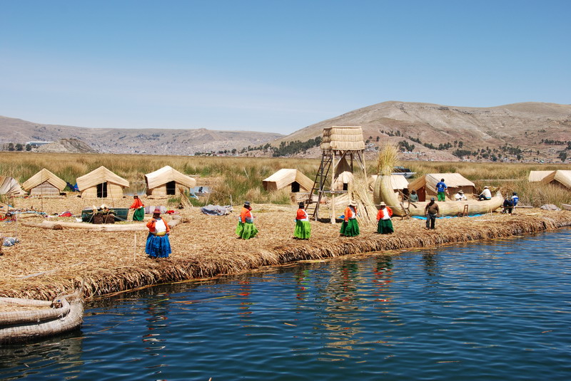
After a 7-hour bus ride through the desert with organ pipe-type cactus and then the high grassy altiplano, I arrived at Puno (pop 118,000), on the shores of Lake Titicaca. Covering 8400 sq. km and sitting at 3808m, this is the world´s largest high-altitude lake. The best way to see the lake is to visit the islands close to Puno so I went on a 2-day tour to see 3 of them. The Islas Flotantes are unique floating islands of the Uros people. The islands are built using buoyant totora reeds which cover big blocks of the root masses of the reeds that are then anchored to shallow areas. The reeds are also used to make their homes, boats and crafts. Tourism is now their livelihood. Because they get so little exercise on their tiny islands, many of the women were as round as they were tall. Originally there were only two islands but now there are 60. Each island has a lifespan of about 30 years.
We then boated to Isla Amantani, an island with 5000 people living in 10 villages. The hillsides are covered with pre-Inca terraces, 80% now not used. We stayed in homestays that provided all our meals. Ours was with an ancient couple that were very sweet. That afternoon was their major festival and the square was a riot of bands and dancers in intricate sequined costumes. On the second day, we boated to Isla Tequile with 2000 people in 6 villages. The people dress in their native costumes indicating who is unmarried and who are the leaders in the community. All the men knit and their marriageability is gauged by their knitting ability (the women weave and do not knit). After a walk across the island, we had a long 3-hour boat ride back to Puno. These 10 days are their annual Festival of the Virgen of Candelaria, and the wonderful parade featured many pan flute bands. The street was decorated with coloured saw dust ¨paintings¨. After visiting the Coca Museum, I took a tour to Sillustani to see the cullpas or funerary towers made from massive blocks.
On the 4th I took the bus to Copacabana, Bolivia on the shores of Lake Titicaca.
Peru costs: 39 days – $3175 = $81.40/day. Peru certainly had the most to do of the countries visited so far. It was interesting to visit in the offseason when it rains virtually every day, usually in the late afternoon or evening. I have just finished reading 1491 by Charles Mann – wonderful reading so pertinent to the country I was travelling through. Other books that I have recently read and very much enjoyed are Cutting for Stone, the Help, and Marching Powder.
Santa Cruz Trek – NP Huascaran – Jan 8-11, 2012 (detailed account)
Guided trek with Galixia out of Huaraz. Supplied a guide (really only a cook) and a burro wrangler named Victor who was incredible – 4 burros, packed up and took everything apart every day and routinely beat us to the destination. On the trip were Jan and Kristina Bonde – a father and daughter from Denmark, Alex and G? – Serbians now living in Berlin, and J? – a very antisocial guy who spoke only Korean and never said a word.
Day 1. Incredible drive from Huaraz past huge granite walls with many high waterfalls, 2 turquoise alpine lakes at 3800 m, past Huascaran (highest peak in Peru at 6750 m), a high pass into Atlantic watershed at 4500 m, and then down to the town of Viliquerca – alt. 3700 m. Only had to carry rain gear and lunch. Tent and pad plus all food provided. Walked downhill past fields of potato, apple, and alfalfa, then up through a small no-road access community to camp at 3800 m. Many cows and sheep are on the long trails. Unusually for this time of year, there was no rain.
Day 2. 15 km day uphill to Punta Union, the continental divide pass at 4750m, then past an alpine lake and spectacular mountains that all looked like the Matterhorn with pure white glaciers and fresh snow. Camped alongside rushing river at 4200m. Rained heavily after reaching camp. A full moon at night illuminated all the great peaks.
Day 3. 12 km. Went to mirador with views of Nev. Alpanayo and Nev. Quitaraju, both over 6000m, then down to broad, wet, flat valley with cows and horses grazing. To left was the Paramount Pictures mountain. Walked on the left side then past 2 big lakes, and then down to the campsite at 3800m. Rained lightly that evening. The valley had very sheer granite walls with many waterfalls and fewer views of the high peaks. Full moon at night.
Day 4. Short 2-hour hike down a narrow valley with a great rushing creek to Cashapampa. Had to wait 3 hours supposedly for a second group that was doing the trek in 3 days, but after a big stink from us finally got them to drive to Caraz where we caught a taxi, 1 hour to Huaraz.
I caught the bus that night to Lima and the next AM to Nasca. No rain during hiking but did rain every evening and night.
Machu Picchu January 17-21, 2012 (detailed account)
Day 1. Up at 4:45, showered, and picked up at 5:30 to join the other 14 in the group (the company was SAS, the biggest company doing the trip) and 2 guides – Fred Reyes and Cesar to bus 3 hours to km 82 (Ollanta) at 2380m on the rail line to begin the hike. The group consisted of 3 Americans (Corrine, Jocelyn and ?), 3 Germans, 3 Canadians (Tom and Jillian from Calgary), 3 Australians (Sam, Pippa, and Beth), 3 Brits (Will, Krem – Bulgaria, and Lawrence) and 21 porters, including the cook. The porters carried 27 kg each and had SAS uniforms. After passing through passport control, we crossed the Urubamba River, followed it for a while and then turned left up a valley, then climbed up to a ruin called Llaqtapata, high above a big ruin (Wilkaraquay) with terraces at the confluence with the Urubamba.

We climbed up to a small ruin above the last with many small niches and rough stonework. Porters set up a lunch tent and a gourmet meal – avocado salad, rice, chicken curry, veggie, banana with chocolate. Continued up this valley to? At 3000m, houses on the trail, then turned east up another valley to start the climb up to the pass. We left the forest microclimate behind, climbing steeply up to the first campsite at Llulluchapampa at 3300m. Big flat camping areas. Everyone was in bed at 7:30. Dinner was likewise sumptuous. Transition zone to grasslands.
Day 2. We were up at 5 every day to eat and start walking by 6:30. We climbed steeply up to Dead Woman Pass at 4200 m, the highest point on the trek. By this time, everyone but Lawrence Kehn (Swansea, Wales) and I, had acquired a porter to carry personal stuff. We carried our sleeping bag, pad and all personal gear while the porters carried the tents, and all cooking and dining gear (including a big eating tent, table and chairs). There were great views both ways along the incredibly rugged, steep-walled valleys. Then there was a steep descent to Pacaymayo, a river campsite at 3600m. Much of this part of the trail was rebuilt, but 80% of the whole trail was original. There are many steps so it is hard hiking. Took a short, steep side trail up to ruins at Runkuracay, an oval or egg-shaped ruin with commanding views of the Pacaymayo river valley.
Then up again to 4000 m over the Abra de Runkuracay Pass over beautiful Inca steps, and down again to Sayamarca campsite with great views to the north. It rained heavily on the way down. That evening we distributed the tips (80S) to all the great porters. The cook and head porter got extra.
Day 3. After a short climb up through 2 Inca tunnels and along nice lichen and moss forests with good Inca buttress work to Puyupatamarca at 4000m with nice ruins.
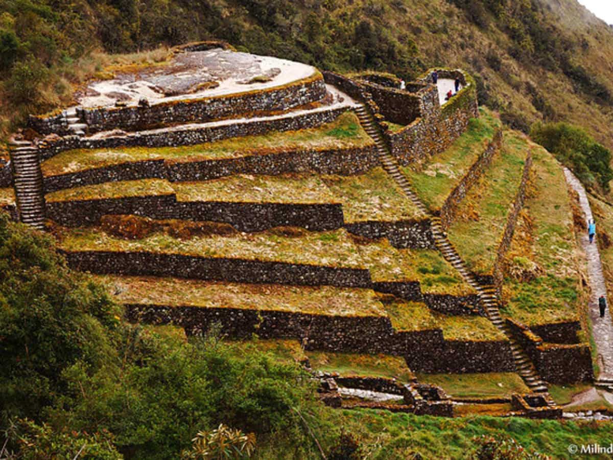
Then a steep descent down the Inca steps to Wuiñay Wuayna at 2650m, our third campsite, where the majority of companies stay, as it is very close to MP. There is a huge ruin here with 50 terraces (each with 5-7 foot rock walls), 14 fountains or ritual baths, many buildings and nice Inca stonework on the top ruin. There was a big waterfall to the side. Rained heavily all evening and night, and stopped at 4 AM just when we got up.
Day 4. Up at 3:45 to have a quick breakfast (3 women waited 30 minutes to use the shit-covered and dirty toilet-papered toilets instead of peeing in the woods – the toilets were disgusting) and hurry and wait with 200 others at the control point that didn’t open until 5:30. It was then a 60 minute almost level walk through the high jungle with bamboo groves, wood bridges, dangerous cliff faces, and rock slide areas with beautiful views to Inti Punku, the Sun Gate.
MP was not visible with all the clouds, but we descended slowly down the steps and path until finally, MP appeared through the clouds – the iconic view that is maybe the visual highlight of the trip. We came down to the area just before the main gate, took many photos and eventually descended all the way down to the main entrance area, where we had a sandwich and used our tickets to formally enter the site. Fred then gave us a grandiose tour visiting the main agricultural areas (about 50 terraces from top to bottom), the Temple of the Condor, the Temple of the Sun with its two windows used to predict the summer and winter solstices, the Inca`s house, the main temple with the Three Windows and the Astronomical Observatory. We cruised through many of the buildings, then caught a bus down to Aqua Calientes to the hotel (Viajeros) and a great buffet lunch. Most filled out the guide evaluation form and tipped the guides (I didn´t as I thought they at best did an average job, and Fred was so full of himself and hogwash – I could not believe a thing he said). Then went out with Lawrence, Sam, Pippa, Beth, Tom and Jillian to go bar hopping, catching happy hour at 4 bars.
Day 5. I got up early to catch the bus back up to MP to climb Wayna Picchu, the big mountain behind that required a separate pass. Did the climb in 35 minutes, passing 46 other walkers to arrive at 8:30. After 20 minutes, the cloud cleared and disappeared several times to reveal great views of the ruins. After an hour on top, I descended the steep trail down the back of the mountain to visit the Grande Caverns with nice ruins and stonework. It was then a long climb back up and around the mountain to regain the trail and return to the trailhead. I then revisited all the ruins, even dropping in on many tour groups to learn as much as possible. I then climbed up to the Inca Bridge (an amazing bridge with wood across a big gap in the stone causeway and a vague trail that crossed a vertical cliff face all grown in with trees. The trail is the only other way to get to MP, but it is not usable now.

I eventually descended to the bus departure point, returning to Aqua Calientes to catch the train at 16:43 back to Ollantaytambo along the incredible class 5 Urubamba River. Then had a 1-hour bus ride back to Cusco, where I stayed again at Pirwa Backpackers.
