
Jan 25-Feb 10
The selection of stores in Mexico is interesting (this came up as I was busy looking for oil for the truck as auto part stores were way down the list). In order of frequency of occurrence were zapaterias (shoe stores – incredibly common, Mexicans must have a shoe fetish), papelerias (paper stores), farmacias (pharmacies – the clerks have minimal drug knowledge), abbarotes (small grocery stores – selling mostly chips and pop but also a wide selection of groceries), cell phone stores, and clothing stores. Leaving San Cristobal the road was very narrow and windy as it moved through rough beautiful mountainous country covered in jungle. Every house and dog seems to deserve a tope. Women and children as young as 6 were walking along the road carrying huge loads of wood using tump lines across their foreheads. Extreme poverty was visible everywhere. I detoured 15 km off the main road to visit the Mayan ruins at Tonina. The ceremonial core of temples is built into a hillside and rises in a series of terraces 80 meters above the grand plaza. One mural has several decapitated prisoners of war and a statue had a headdress like the one in the previous nights play. The expansive view from the top was of a pastoral lush valley.
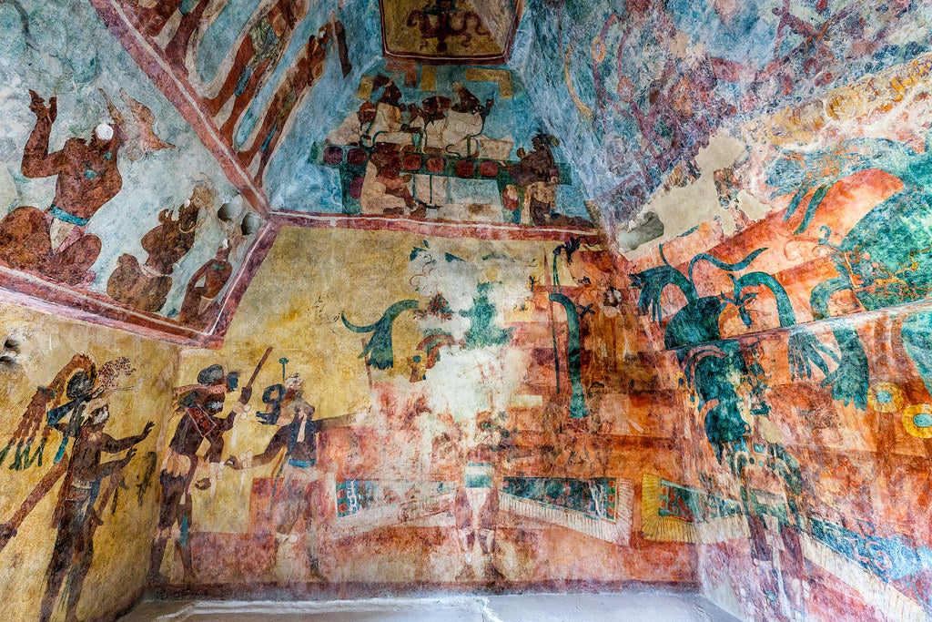
North of Tonina, I stopped at Agua Azul for the night. Next to me was a lovely couple from Nanaimo in their 34-foot fifth wheel. I congratulated them on their courage to have ventured so far in such a big rig. Their trip was in the reverse direction of mine, having started down the Gulf Coast of Mexico. Their values in seeing Mexico were the same – not stopping at any one place for long and seeing a lot. I got up at sunrise to photograph the many turquoise pools separated by multiple dazzling white waterfalls surrounded by verdant jungle. This was the most beautiful spot in Mexico I have seen so far. It was such a nice place that I decided to take a day off, sit and read, work on my pictures and go for a swim. Little girls carrying baskets of fruit balanced on their heads constantly bug you for a sale. Ten kms north is Agua Clara, where the Rio Shumulha broadens into a tranquil, shallow expanse of turquoise water. Twenty kms south of Palenque, the spectacular waterfall of Misol-Ha cascades 35m into a wide pool surrounded by lush tropical vegetation. A path leads behind the falls. Proceeding onto Palenque, I was very excited to arrange a four-day-three-night tour SE to the Mayan ruins of Bonampak and Yaxchilan on the Guatemalan border and then on to Flores and the ruins of Tikal in Guatemala (cost 3,200 pesos). Palenque, as a town, has little to offer. I camped at Mayabell, a gorgeous campground set in the jungle near the ruins. It catered to a wide assortment of guests, older people in RVs, families staying in the cabins, and many Bohemians staying in hammocks in palapas (40 pesos/night) who were heavily steeped in the drug culture. Marijuana was everywhere. I enjoyed talking to an Austrian fellow covered in tattoos who knew more about marijuana and the manufacture of derivatives than I could ever hope to understand. He took me to a beautiful waterfall deep in the jungle. It has rained for the last two nights, the first time in over two months, and is warm and humid. The ruins of Palenque are made up of 500 buildings spread over 15 square km, but only a few have been excavated. There were big pyramids, many with murals, and this was certainly the most impressive Mayan sight I’ve seen so far. It took me three hours to see everything – it was a great quads workout. While at the ruins, I had the truck and camper washed for 100 pesos – a good deal, especially with the three months of bugs accumulated on the camper. Excited about leaving tomorrow for Guatemala.
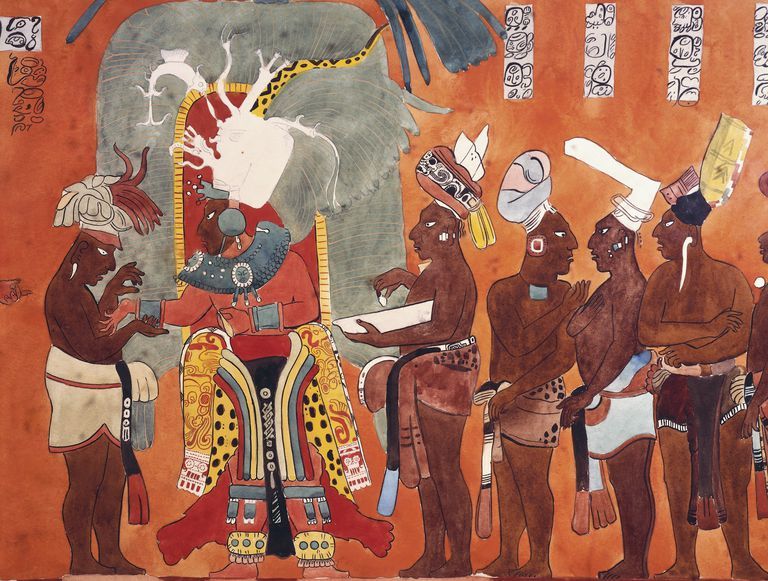
Off at 6 AM, we drove the 178km to Frontera Corazal, a small riverside frontier town on the Usumacinta River, which forms the boundary between Mexico and Guatemala. This is the largest river between Texas and Venezuela and discharges 105 billion cubic metres of water into the Gulf of Mexico each year. We boarded long outboard-powered launches to travel 32 km down the Usumacinta to access Yaxchilan, a Mayan ruin in a terrific jungle setting above a horseshoe loop of the river. Howler monkeys were roaring throughout the visit and were frequently visible. Besides the setting, Yaxchilan is famed for its ornamental building facades and roof combs, and its very nice stone lintels carved on their undersides with conquest and ceremonial scenes. Compared to Palenque, this site was very simple with minimal reconstruction. The city peaked in power from AD 681 to 800 and was abandoned by 810. Returning upstream, we drove to the ruins of Bonampak, which were not discovered until 1946. A small site, it is famous for its full colour murals depicting prisoner sacrifices, bloodletting, and dancing to celebrate the consecration of a new infant heir – quite spectacular. I wish I had brought my SLR camera and tripod as flash was not allowed. I stayed that night at a lodge set in the Lacondan jungle (a huge area, about 1/3 of which has been deforested). The Lacondans are the local indigenous people and dress in long white tunics and have long hair cut in a fringe.

The next morning, we returned to Frontera to take the same launches upstream 13 km and entered Guatemala (there is no bridge across the river). After a long 3-hour drive, most on very rough gravel, we arrived at Flores, a small touristy community located on an island in the middle of a lake. The countryside we travelled through was flat, deforested jungle with fields of corn and many humped, brahma-like cattle. With unexpected expenses and the bank machines inoperable, I was looking forward to having nothing to eat for two days (now there was stress, as I hate missing a meal), but was finally able to find an ATM that would give money. The Guatemalan currency, the quetzale, is worth .65 of a peso but has less purchasing power, making most things expensive. It was hot and steamy with temperatures in the mid 30’s.
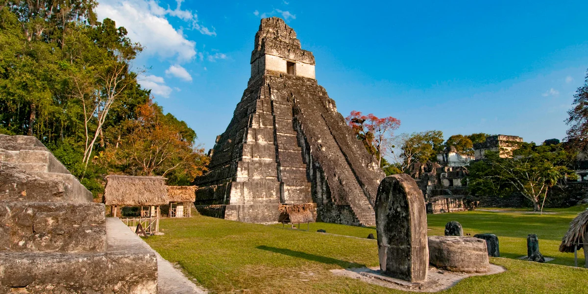
I took the sunrise tour to Tikal, getting up at 3:30 AM to drive the 60 km to the ruin. We watched sunrise from the top of Temple 1V, the highest temple in Mesoamerica. With other temples looming out of the jungle and howler monkeys roaring, it was a unique experience. The other temples around the Grand Plaza have been 90% reconstructed and are impressive pyramids with very steep sides and tall white temples on top. The tops of the pyramids are accessed by wooden stairways as they are simply too steep to climb. The nicest stela are now on display in the British Museum and in Switzerland. We saw many toucans, white-faced parrots and another tropical bird with a yellow tail and orange beak not listed in my Sibley’s bird book. The entrance fee to Tikal, at $24, is four times the price of any other Mayan site. I went to the town adjoining Flores, Santa Elena, to eat, explore and see the marked poverty. Tuk-tuks are the main taxi and armed guards are in most stores. I am now thoroughly disappointed with restaurant food as it is usually poorly prepared and many times more expensive. There were several Israelis on the tour – they are the least friendly, seemingly unhappy people I’ve met. Frenchmen are very unilingual and not that cute a bunch. I watched the CNN Obama/Clinton debate and was quite impressed with both. They will be a welcome change after dealing with W for seven years. Up at 5 AM, it was a long drive all the way back to Palenque. My total cost for January was $1,670.
I parked that night in the parking lot of the Palenque Museum that I had missed because it was closed on the Monday I originally visited the ruins. I felt safe with three cops all with big shotguns 50 yards away. They all came to admire the camper and bicycle. The excellent museum had many large murals, stelae, incense burners, jade jewelry and jade masks. The highlight was the sarcophagus of Pakal, the ruler of Palenque until 683 AD that was found deep in the Temple of Inscriptions. The ornately carved lid weighed 3 tons and the inside contained his skeleton with huge amounts of jade jewelry. The museums are necessary visits as the ruins themselves only have buildings.
The drive SE into Campeche State was over pancake flat forested land. In the morning, I drove 60 km south off the highway to the Mayan ruins of Calakmul. The road deteriorated to one lane with many low trees. I ripped off the front 50 watt solar panel so now almost everything on the roof of the camper has been forcibly removed in some way. Calakmul is believed to have been the largest city-state in the Mayan world with 60,000 people living there at its height from 300-700 AD. 6,750 structures have been mapped to date. Its tallest pyramid at 173.8 feet high had a footprint of five acres. Its 120 stelae are dated 495 to 909 AD and are the most of any Mayan site – the ones still present are all heavily eroded. I’m not sure it was worth the long drive and camper damage. Returning to the main highway, I went to the nearby ruins of Balamku. Much smaller, it is renowned for a fantastic, huge stucco frieze found inside a ruined pyramid in 1990. The many anthropomorphic creatures still have much of the original color visible. I went to see the ruins at Becan outside of the town of Xpuil but on entering the parking lot, I was accosted by eight boys who wanted money to watch my truck while I visited the site. Scared to leave it unattended and too cheap to pay them, I left. I’m starting to get ruined out anyway and Becan had little special to offer. I spent the rest of the afternoon straightening all the twisted brackets for the solar panel.
The next morning, after crossing from Campeche State into Quintana Roo State, I visited the Mayan site of Kohunlich, known for its Temple of Masks featuring haunting masks with star incised eyes, mustaches and nose plugs. 6.6 feet tall, these masks are a rarity. The ruins are in a nice jungle setting. The day went very well as I reinstalled the solar panel (thank god for hot glue, which works well to fill the screw holes ripped apart) and found my tool bag, which I thought had been stolen in Agua Azul (the heavy bag had jumped out of the drawer when I hit a deep pot hole). Arriving at Chetumel, the capital of Quintana Roo, I reached my most southerly point and the Caribbean Sea. Finding a good supermercado, I was able to replenish my groceries and had one of my favorite home-made meals, vegy tacos (refried beans – onions, mashed black beans, freshly ground cumin; fried onions; cucumber; salsa fresco – chopped white onion, tomato, cilantro, minced serrano pepper, garlic, oil; and guacamole – avocado, chopped onion and cilantro, minced serrano pepper, lime juice, garlic, cumin, salt; on warmed small soft wheat tortillas – (curved hard taco shells don’t exist in Mexico) mmmm! Since I haven’t been able to buy milk other than milk in tetra pacs, I am forced to eat all my meals with beer or margaritas. After supper, I went for a long walk on the Malecón. The street snacks consisted of elotes (kernel corn with mayonnaise, lime juice and hot sauce), French fries with deep-fried cut-up hot dogs, and rica marquesitas (crispy hot crepes with shredded cheese). I camped right on the Malecón. The good Mayan Museum in a beautiful building with green marble floors, explained the complex numerical and calendar systems.
Tulum is famous for its ruins. After paying 50 pesos to park the truck plus the 48 peso entry, this was certainly the worst Mayan site I’ve visited so far. It was also the busiest with thousands of people all in large tours with guides. I’m not sure what they could have been talking about. It takes longer to walk from the parking lot to the ruin than it does to see the ruin. The only saving grace is the location on the edge of the beach and the few iguanas wandering around. I drove 11 km north to a large bay protected by a coral reef and snorkelled for 2 hours, seeing fish only far out in the bay near the coral. The water was warm and the beautiful green colour of the Caribbean. I talked to a man from Maryland who was a complete red neck conservative. Rich and with a large house on the beach, we disagreed about everything. He wished that W could run again as he believed that he would be better than anybody else! I travelled fairly quickly through the large triangle at the tip of the Yucatan Peninsula with its many resorts and tourists in Cancun, Playa del Carmen and Cozumel, and then headed toward the Mayan ruin of Coba. Cancun was the farthest point from home on the trip, and it feels good to finally be on the return leg. My odometer reading since leaving home was 15,650 km. Coba was another ruin that I should have missed. With another 50 peso parking fee (it seems that the only ruins that charge to park are near Cancun), the OK ruins were each separated by long distances, and this is the only ruin that has bicycle taxis and rental bicycles. All the stelae were completely eroded, so no image could be discerned on any of them.
After staying in the small colonial city of Valladolid, I drove north to the ruins of Ek Balam, a small site with a well-preserved stucco mural with beautiful angel like winged figures unique in Mayan art and then east half way between Cancun and Merida to Chichen Itza, one of the finest Mayan sites. Not abandoned till 1200 AD, it is one of the “newest”, and is now a UNESCO World Heritage Site. The ruins surround a breathtaking pyramid, El Castille. Each of the four sides has 91 steps which with the platform on top makes 365. At the spring and autumn equinoxes, the sun lights up a bright serpent pattern on the wall supporting the north staircase. There is the Group of a Thousand Columns and the Temple of the Warriers, many with carved columns, a huge ball court and the observatory that allowed celestial sightings used to keep their elaborate calendar system. These and the many other buildings all have well-preserved carvings on many walls. I liked this ruin more than any other so far. There were huge crowds all arriving on buses from Cancun and Merida. Every one of these ruins has many vendors selling kitsch – they organize large numbers of ornaments or t-shirts on the ground meticulously, don’t seem to be selling much and then pack it all up at the end of the day.
Kukulcan Temple.
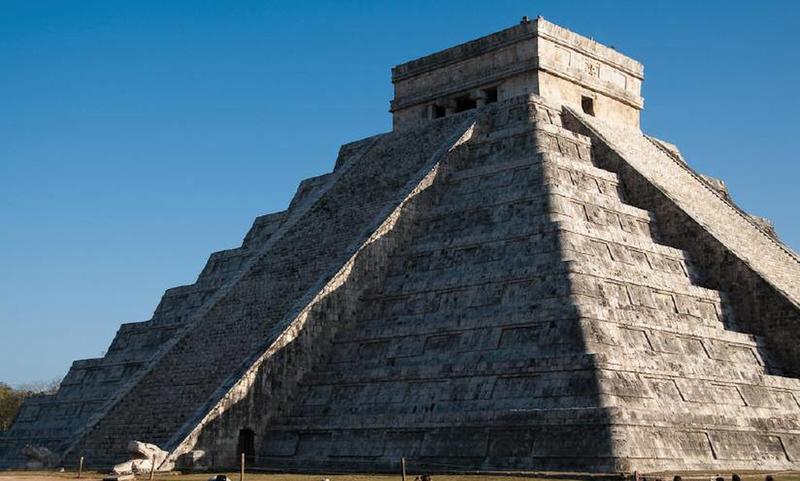
It was common for the Maya to merge their interests in astronomy and building, as can be seen in the Chichen Itza Kukulcan Temple. When the sun’s rays illuminate the pyramid during the spring equinox, a huge serpent-like image is seen between the shadows. In this image, look towards the base of the temple to see the stone snake head lit by the sun with a body leading up the staircase.
Merida (pop. 1,000,000), is the capital of Yucatan and like most cities has a few mediocre churches, a state government building with nice murals, two art museums and an OK Museum of Anthropology. It is renowned for its music and dance with performances every day especially on Sunday when all the central streets are closed. The most exciting thing was I ran out of propane and floundered around for several hours trying to find some. I drove SE to the cenotes south of the small town of Cuzama. Cenotes are large freshwater sinkholes part of the world’s largest underground river system. They are former caverns whose roofs have caved in and are sacred to the Mayans. Occasionally several hundreds of meters deep, their water is unbelievably clear and have amazing stalactite and stalagmite formation making them a favorite for divers and snorkeling. Half the fun of these particular cenotes is getting to them on small railway trolleys pulled by horses on rickety, crooked, and narrow (2’) rail lines. If you meet another car, one of them must unload and hoist the car off the tracks to let the other pass. One visits three cenotes over rails running for nine kms. The first is large and had hundreds of bats wheeling around the cavern. The last goes down a steep ladder though a tiny hole. I went for a wonderful swim in the warm water. Further south the small ruins of Mayapan is infrequently visited. At its height from 1200 to 1550 AD, it has two pyramids, an observatory, cenote and good fresco paintings and frescos. There are few cars and everybody uses a bicycle or three-wheeled bicycle taxi in this area. After negotiating two towns with no signs (Oxkutzcab had wonderful murals above its market) and several one lane roads, I went to the Loltun Caves, the largest in Yucatan. Human presence in the caves has been dated to 9000 BC. With huge caverns, Mayan carvings and 2 large rooms filled with trees, the caves were a good stop. The topes have really taken a toll as both my rear tie downs for the camper are destroyed – the metal pipe has fractured and the chains hang loosely. With 3000+ kms to negotiate before the US border and no prospect at getting them replaced before then, I need to be very careful with all future topes and potholes.
February 10th was a big ruin day. All these ruins are in the Puuc style – thin squares of limestone veneer, decorated cornices, boot-shaped vault stones, rows of attached half columns and heavily decorated upper facades (puuc is Mayan for “hilly area” in this pancake-flat area of the Yucatan). Most were at their peak from 750-1000 AD. This area of the Yucatan south of Merida has good soils, is tropical and dry with its annual 44 inches of rain falling between May and October. There are no cenotes or rivers and rainwater was collected in aguadas (natural holes in the ground) and in man-made chultunes (cisterns) built into the ground, sometimes right inside a house or patio. Most structures are adorned with hundreds of stone masks and carvings representing the rain god, Chac-Mool, easily identified by his prominent hooked nose. Labna has a large palace with many chultunes, a building with a large roof comb and a beautiful arch with ornate carvings. Xlapak is small and has no fee. Sayil has a 160-foot-long palace with columns and rich carvings of Chac, and a human phallic figure. One chultune holds 7000 gallons of water. Kabah’s most ornate building’s west side has 250 Chac masks all with the elaborate curved nose and there is a large arch marking the end of the 20 km long elevated road or sacbe extending from Kabah to Uxmal. Uxmal is one of the top Mayan sites and had a fee of 98 pesos. Most buildings are made of hard pink limestone and have been all reconstructed (if not reconstructed, most of these sites would simply look like piles of rubble covered in jungle). It has two large pyramids and all buildings have intricate, geometric mosaics sweeping across the upper parts of elongated facades. Chac’s image is everywhere in the form of stucco masks protruding from facades and cornices. This was my last and probably favourite Mayan site of the nineteen I have visited. All are different and each offers its own charm. The Mayans were an amazing people. With an advanced calendar dating back to 3114 BC, math and incredible building skills, they were the foremost civilization of their time. It is thought that overpopulation and drought forced them to abandon their cities mostly by 900 AD. I drove the 176 km to Campeche, the capital of the State of Campeche over flat straight roads.
A few odd things. The monarch butterflies find this tiny spot in Mexico using a circadian clock and a sun compass (heard this on CBC). The license plate that was “stolen” was most likely removed by a policeman when I was given a parking ticket in Durango. They don’t leave a note and this is how they guarantee payment of the parking fine! Carnival has been this past week and unfortunately none of the towns I was in participated. The largest celebrations in Mexico are in Mazatlan and Veracruz.
It sounds like you are still in the thick of winter. I’m looking forward to cooler temperatures; as I go north I find the humid heat uncomfortable. There have been thunderstorms, lightning and rain for the last 3 days. Can’t wait to get home. It should be fast travelling from here on as I have few destinations on my list and generally flat roads.
