Tassili n’Ajjer (“Plateau of the Rivers”) has one of the most important groupings of prehistoric cave art in the world. A national park with an area of over 72,000 km2. It is in the Sahara on a vast plateau in southeast Algeria at the borders of Libya, Niger and Mali. It was placed on the World Heritage Site list in 1982.
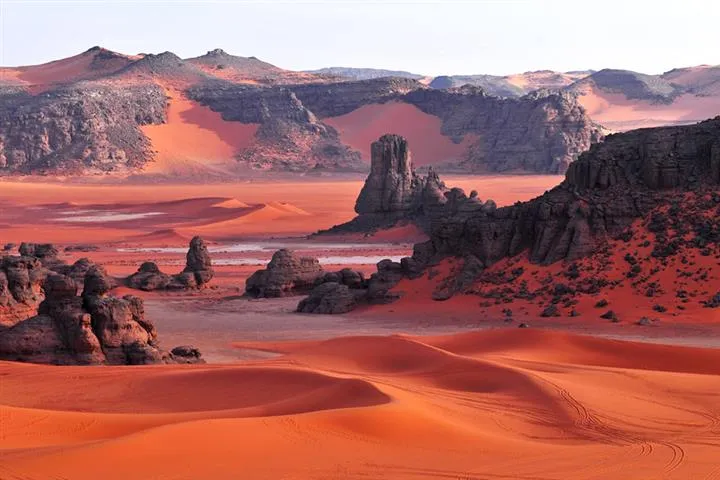
The park has geological formations of rock forests and eroded sandstone, which resembles a strange lunar landscape. The range is composed largely of sandstone with 300 natural rock arches.
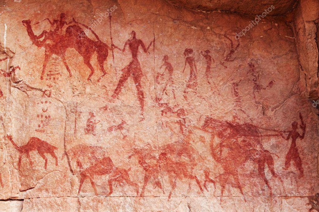
Prehistoric rock art dates to the early Neolithic era at the end of the last glacial period during which the Sahara was a habitable savanna rather than the current desert. The earliest pieces of art are assumed to be 12,000 years old. The vast majority date to the 9th and 10th millennia BP or younger.
Among the 15,000 engravings depicted are large wild animals including antelopes and crocodiles, cattle herds and humans that engage in activities such as hunting and dancing. According to UNESCO, “The exceptional density of paintings and engravings make Tassili world famous.” As some date back up to 12,000 years, they provide unique insights into the environmental, social, cultural and economic changes across 10,000 or more years.
The earliest pieces of rock art are engraved images reflecting a past vibrant fertile environment teeming with life – elephants, rhinoceros, hippopotami, fish, numerous predators, giraffes, and plains animals such as antelope and gazelle. The human figures depicted in this period were small in stature. They hold throwing sticks or axes. More than simply hunting scenes, they are likely to reflect people’s place within their environment and their relationship to it.
The area is especially famous for its Round Head paintings. Thought to be up to 9,000 years old, they are figures with round, featureless heads and formless bodies, often appearing to be ‘floating’. Most animal depictions are mouflon (wild mountain sheep) and antelope represented only in static positions and not as part of a hunting scene.
The subsequent Pastoral Period, from around 7,500-4,000 years ago, portrays a very different world to the preceding ethereal Round Head period and coincided with the transition from a temperate Sahara towards aridification. Images are stylistically varied, which may attest to the movement of different cultural groups. Depictions now include domesticated animals such as cattle, sheep, goats and dogs; scenes portray herders and men hunting with bows, and representations of camp life with women and children – scenes that reference more settled communities.
The last defined period is stylistically characterized by camels, representing an alternative method of negotiating this arid and harsh landscape. Camels can travel for days without water and were used extensively in caravans transporting trade goods and salt. Depictions in this period continue to include domestic animals and armed figures.
Fungoid rock art. The relationship between humans and psychedelics in the ancient populations of the Sahara, Used psilocybin mushrooms as part of their religious ritual life, citing rock paintings showing persons holding mushroom-like objects in their hands, as well as mushrooms growing from their bodies. The painting that best backs the mushroom hypothesis is the Tassili mushroom man Matalem-Amazar where the body of the represented shaman is covered with mushrooms.
Day 1
Our flight arrived at 2 am, we were picked up by our local guide and taken to the headquarters of Azjar Tours.
DJANET (pop 14,655 2008) is an oasis city located 412 km (256 mi) south of Illizi. It’s home to the Kel Ajjer Tuareg people. The region of Djanet has been inhabited since Neolithic times. There were periods of ten thousand years when the area was not desert. The flora and fauna were luxuriant as is seen in the numerous rock paintings of Tassili n’Ajjer around Djanet. Populations of hunter-gatherers lived there.
Djanet was founded in the Middle Ages by the Tuareg.
Djanet, and the nearby towns of Azelouaz, El Mihan, Adjahil and Eferi, lie in a valley carved by the intermittent river (wadi) Oued Idjeriou through the southwest edge of the Tassili n’Ajjer mountain range and east of the Erg Admer sand dunes. The Tadrart Rouge is located to the southeast and is a southern prolongation of the Libyan Tadrart Acacus.
Due to the cooler air, higher humidity and higher rainfall in these areas, the nearby mountains support a greater amount and variety of wildlife than lower-lying areas in the Sahara. Djanet (1,035 m) has mountains to the east and north as high as 1,905 metres (6,250 ft)
Djanet has a hot desert climate with hot summers and mild winters. The city is dry throughout the year, with an annual average rainfall of just 14.6 millimetres (0.57 in).
Azjar Tours: contact@azjar.com; www.azjar.com; +213 29473151
EC: towel, towel? omelet, omelet? and were off at 09:30 with our driver – Ahmed, 64 but looks much older, and our cook, Mohammed, 42. Neither spoke English and I relied on Google Translate. They were great guys.
Day 2 – a scenic drive to Moul N’Aga with its beautiful landscapes and Ajajar rock paintings.
I found it amazing how skilled Ahmed was in finding all the pictographs and petroglyph panels. We saw at least 20 over three days. He doesn’t use GPS, just his memory. I asked Ahmed how many trips he had made here. He said many, possibly a thousand!! He had lost track.
I blew it by not downloading offline maps so I couldn’t record our camp, lunch locations or the rock art sites. I don’t have a clue where we were – just south of Djanet near the Libyan border.
The landscape is eroded ridges, low mountains (sometimes with eroded cliffs) and a lot of sand. The rock disappeared and we crossed a rocky desert. A remote intersection had a sign Libya to the left, and Niger to the right. We continued south.
We had lunch in an unattractive wadi with thin plates of sedimentary rock and entered a big valley with high sandstone domes, cliffs, and buttes rather reminiscent of Utah/ Arizona.
The Ajajar rock paintings are in three main sites in overhangs. Painted in red ochre, they are small, beautiful, finely executed paintings with great detail.
• A giraffe
• Large cattle-like animals with horns and men.
• One rock we stopped at had bas-relief fossils of a small plants
Ahmed took a long time to hack off wood from a fallen tree. He always lit a fire for tea. Like all northern Africans, tea is an art form. As they use leaves, there is a long, elaborate decanting process pouring the tea in long streams between two pots to catch the leaf debris in the foam that is discarded. They use a lot of sugar, more mixing and it is too sweet.
Out in the middle of nowhere, we passed a police checkpoint, six guys stranded out here must be no fun.
We drove a long way down the winding valley and saw at least 21 other SUVs and Hilux. Nobody stopped so I have no idea who the tourists were.
We eventually camped in a remote side canyon under a huge cliff. Mohammed makes too much food, especially as I eat little. Anything not eaten is discarded. Ahmed sang and played a “flute” made of a copper pipe with drilled holes. He plugged the end with a cloth for a better sound. Ahmed kept up a continuous banter in Taureg as we drove. Mohammed grunts along.
ON I slept in the open. This is a great dark skies area. I saw at least 10 meteorites in ten minutes.
Day 3
We stopped at three petroglyph panels: in the red dunes of Tin Merzouga.
• 6 large elephants
• A large giraffe being fed by a man.
• Large aurochs with designs on their bodies.
Then in a small overhand, another wonderful pictograph site with men and aurachs.
Continuing southeast, we drove down a large wadi with more cliffs, buttes and arches until we arrived at great, orange dunes punctuated with dark grey rock outcrops.
• More arches and one spectacular one similar to Delicate Arch in Arches NP in Utah. It was a spectacular landscape, possibly one of the best I have ever seen.
We passed a large herd of goats and a shepherd in the middle of nowhere. Where was the water?
After an extended 3-hour lunch (salad, fries and cauliflower fried in an egg batter), there were more pictographs:
• Some very amateurish camels but a good finely painted aurach with a man
• A large anthropomorphic man and another good aurach.
• 8 wild camels. Here we were very close to the borders of Libya and Niger.
• More arches
• An eroded knob with four legs and a snout that looked distinctly like a pig.
ON on a dune very near the Libyan border
Day 4
We had our usual 9 am departure through a fantastic landscape of eroded cliffs, buttes, knobs, holes and arches. We stopped at the following:
• Pictograph panel: unusual giraffes painted in thick white paint.
• Two very nice giraffes in white with red markings on their necks.
• Many panels of men holding spears. All excellent finely drawn pictographs
A water hole in the rocks with very milky water. 8 vehicles of older Italians.
• A rock with 4 holes or arches and then some wild dune driving.
• Petroglyphs of giraffes, a man with big earrings and a fine antelope that looked like an elk. We had lunch, the usual 2-hour affair with most of the truck unloaded.
• Petroglyphs of large aurochs with smooth outlines – world-class
• Petroglyphs: Large black boulder with several giraffes on the front, several elephants on the right side and a few mediocre humans on the back left.
• La Cathedral (3 large arches). These were unusual in that they were higher, and vertical in shape. One was very large (I’m guessing one of the tallest arches in the world – Shipton’s Arch near Kashgar, China is the largest vertical arch in the world). Nearby were two more arches, one sitting on the top of the rock.
• The Mushrooms. Some small pillars eroded on the bottom.
Day 5 Thur Nov 3
Return to Djanet. BF was at 7 am and we were off at 8, the earliest start to any day.
• Petroglyph of an elephant.
• Petroglyph of 3 giraffes.
After lunch about 20 km south of Djanet, Ahmed continued driving in the desert.
• An eroded soft rock that looked like an elephant.
• Two large rocks, one with a modern “petroglyph” carved with three cattle heads with rakish horns. The other rock had a “knob” with an arch on one side.
• Two panels of pictographs with cattle and men, finely drawn with great detail.
We stopped at a great viewpoint of the entire desert area, a gas pipeline and a mine. It took 2 hours to reach the military checkpoint, and shortly after, the paved road back to Djanet. We returned to the Azjar Tours residence. We spent the night there before our flights via Paris to Douala, Cameroon.
I was confused about our route from the beginning, as I had failed to download Google Maps for the area. The entire time in the Tadrart could have been done in possibly three days. We had late starts every day, 2-3 hour lunch breaks and ended each driving day early by 4 pm. We arrived back at Djanet shortly after noon.
The following were on the itinerary, but we didn’t see them.
The Oasis with Foggaras and the Ksour of the Grand Erg Occidental (30/12/2002). The Saoura Valley was a major Trans-Saharan caravan route that joined Gao in Malian territory after crossing Tanezrouft. It is between the reddish escarpments of the Hamada du Guir to the west and the blond dunes of the great western erg to the east. Many ksour are still occupied (Aguedel, El Guarda, Guerzim, Kerzaz…).
At Le Touat and Gourara oases, underground galleries have been dug in the sandstone and penetrate the upper water table and ensuring the gravity flow of water
The Touat has 135 ksour extending over 200 km between the Maghreb and Sudan. Caravans from Sigilmassa, Fez, Tlemcen, Tunis or Timbuktu carrying slaves and gold from the south, wheat and fabrics from the north used this trade route. There are vast fortified houses with corner towers and fortified attics. 600 of the original 995 foggaras still irrigate the palm groves. 200 km of galleries.
Timimoun: the red oasis, is one of the most beautiful oases in the Sahara. Red predominates in clay and the colour of sand. The old ksar, enclosed in its walls has a maze of alleys. Berber-speaking zénètes. The city of Timimoun dominates a vast salt lake, the sebkha on the edge of which are dozens of ksours (Messin, El Gasba, Tlalit…) and whose casbahs cling to the rocky escarpments. The sebkha that we crossed to reach the large palm grove of Ouled Saïd is a salt lake 75 km long.
The oases of Tidikelt have 300,000 palm trees organized into 28 oases and irrigated from 125 foggaras. 10 km to the east is a deposit of petrified wood (old silicified trees whose trunks reach a diameter of 1m. These vestiges date back to the secondary era).
Oued souf (30/12/2002) Wadi souf is a set of unique oasis in full erg. The palm trees are planted directly above the tablecloth at the bottom of vast funnels dug in the sand. Secondary crops are grown on the edge of the funnels and irrigated by outrigger wells. This type of oasis is not based on a geomorphological structure or an apparent hydrographic system but is a completely artificial creation. The maintenance work can never be interrupted due to the continuous wind and sand.
Souf has sand roses, fennec foxes and carpets of high wool or camel hair. 15 km west of El Oued: the oasis of Ourmes.
El Oued: the city of a thousand domes and capital of the Souf. The architecture differs from that of other Saharan cities. Instead of terraces, domes crown the houses.
Hoggar National Park – The Royal Mausoleums of Numidia, Mauritania and Pre-Islamic Funerary Monuments (17/01/2012). These are funerary goods produced by a brilliant original civilization, dating back to different periods and regions, both African and Mediterranean. They testify to the diversity of architectural designs and craft techniques developed over several millennia.
The Tin Hinan Tomb, Hoggar, 80 km west of Tamanrasset and 850 m. 5th century AD
El Goléa oasis
Spend the night in Djanet at Ouan Aher or else Indjaren (camping)
Ekker and Reggane nuclear test sites. The two nuclear testing grounds that France used in the Sahara desert in Algeria for its first atomic bombs in the 1960s. The very first in 1960 was followed by another four atmospheric tests at the site. After Algeria gained its independence in 1962, France still carried out nuclear testing but moved to a different site underground.
In the “Beryl incident” in 1962, the seal didn’t hold on the underground tunnel where the explosion occurred and radioactive material was blasted into the air. This affected a few soldiers, others fled their shelters and two high-ranking politicians. French nuclear testing in Algeria came to an end in 1967 and all other French tests were conducted in faraway French Polynesia (Marquesas) up to 1996, long after the other big nuclear nations (especially the USA and USSR/Russia) had banned all such tests.
There isn’t much left to see, except some ruins and twisted metal (some still radioactive!). The In Ekker site is more accessible as it is west of the main N1 trans-Saharan road. The test site near Reggane is further away.
+++++++++++++++++++++++++++++++++++++++++++++++++++++++
In the Algerian desert, dazzling alfresco galleries provide an eloquent record of ancient civilizations. Here’s how you can visit.
The region is a geological wonderland of uncanny rock formations lapped by orange dunes. Eons of erosion have sharpened the sandstone into pinnacles, worn apertures through high escarpments, and sculpted outcrops into surreal and zoomorphic forms. The park is thought to contain over 300 natural arches alone.
But these rock forests are only half the story. Tassili’s majesty lies not just in the visual splendor of the rocks, but also what past generations have left on them.
Tuarag guide Abdellah Elies explains the legend behind the “Crying Cows,” a celebrated ancient engraving on rock face located between Djanet and Tadrart Rouge. The herd is said to represent the despair of the region’s herders as the “African Humid Period” came to an end and the green Sahara turned to dust.
Among Tassili’s most beautiful areas is Tadrart Rouge, accessible via 4×4 tours from the oasis town of Djanet, a two-and-a-half-hour flight from the Algerian capital, Algiers.
As the guides who run the tours—invariably members of the nomadic Tuareg tribe—identify places to pull over, visitors will often see ancient etchings and paintings decorating the rock.
The French archaeologist Henri Lhote, who documented many of Tassili’s 15,000 pieces of rock art in the 1950s and was later denounced for his vandalistic working practices, vaunted the region as “the greatest museum of prehistoric art in the whole world.”
These alfresco galleries are an eloquent ethnological record of the peoples who were drawn here through the ages. Curiously, many of the most prominent and accomplished petroglyphs depict large mammals more commonly associated with sub-Saharan Africa, including elephants, giraffes, rhinos, and hippopotami.
A pyramidal rock in Boumediene features engravings of an elephant and human figures. Neolithic artists are thought to hav…
An engraving of a long-horned cow was carved on a rock outcropping overlooking the plains of Boumediene.
A view from inside a cave looks out over the rock formations of Oan Atan, an area of mesas and sandstone outcroppings in Tadrart Rouge.
Engravings of giraffes, like this one in Boumediene, in Tadrart Rouge, are a common sight in the national park. They recall the “Africa
When the Sahara was green
The epic subtext to this natural and human-made artistry is the “greening” of the Sahara. The scale of the erosion, especially in the deep-carved ravine systems to the north, indicate that Tassili’s parched wilderness was once crisscrossed by waterways.
Paleoclimatologists have speculated that, between 11.7 to 5.5 thousand years ago, changes to the tilt and orbit of the earth in relation to the sun warmed the northern hemisphere.
During this “African Humid Period,” longer and more intense summer monsoons filled geological basins with lakes and wetlands. Great rivers connected the Atlantic to the Mediterranean shoreline of the Maghreb. Large mammals roamed the endless grasslands
The “Crying Cows” is a well-known engraving located off the road that runs between Djanet and Tadrart Rouge..
The engravings found in the Dider Valley, such as this stylized impression of a cow, are among the most celebrated and artistically acc..
An aerial view captures the “rock-forests” near the southeast Algerian oasis of Djanet, on the western fringe of Tassili n‘Ajjer National Park. The area’s rock formations are the heavily eroded remnants of a pre-Cambrian sandstone plateau.
The rock art in Tassili n’Ajjer tracks the climatic shifts that were to follow. As the region’s weather patterns evolved, so did its human society. Several overhangs feature detailed, naturalistic pictures of piebald (irregularly colored) cattle, recalling the transition from hunter-gathering to mobile pastoralism. Many of the surviving images from this “bovidian” era are drawn in carmine paint, derived from crushed stone mixed with cow’s blood.
Abdellah Elies, a Tuareg guide, walks over the dunes of Moul Naga, a waypoint on the classic touring route around Algeria’s Tadrart Rouge, among Tassili n’Ajjer’s most beautiful—and accessible—regions.
One exception is among the region’s most famous artworks. On a lone outcrop, near the road that today runs between Djanet and the Libyan border, is an etching known as the “Crying Cows.” Carved by a master craftsman, it shows a group of cattle in sweeping, calligraphic lines.
The weeping cows are a presentiment of the Sahara’s arid present. As an age of fecundity was succeeded by an age of dust, the elegant glyphs gave way to diagrammatic scrawls of camels—the hurried, “I was here” graffiti of people living on the move.
In recent decades, local instability, most notably civil conflicts in Libya and Niger, has prohibited access to much of the national park. The sheer size of wilderness places it beyond the reach of Algerian military patrols.
A sleeping antelope is carved into the expansive stone surface in the Dider Valley.
Although Tadrart Rouge alone feels like a world unto itself, much of Tassili’s rock art, and the astonishing landscapes that form their backcloth, remain lost to time.
Teams consist of a guide, driver, and cook, and come equipped with camping gear, food, and water. A seven-day tour with Fancy Yellow, including domestic flights, costs around $770 per person.
Visitors with more time might want to combine a trip to Tassili with a trip to the Algerian Sahara’s other great marvel: Ahaggar National Park. This extraordinary mountain range is accessible from the town of Tamanrasset, which is a 45-minute flight west from Djanet.
Strande Ancestors & Relatives While there were a number of Strandes who preceded Grandpa Strande…
Ofstedahl Ancestors & Relatives[1] The first Ofstedal (Ovstedal) ancestor to arrive in North America was…
This is a description of a difficult traverse completed in 13 hours, car-to-car by Jaron…
SWITZERLAND Intangible Cultural Heritage Alpine pasture season Avalanche risk management Basel Carnival Holy Week processions…
Mapping how the U.S. forcibly took Indigenous lands Not long after the Great American Experiment…
What is cyclospora? Here’s how the parasite causing ‘explosive diarrhea’ spreads As cases of cyclosporiasis…