
Sudan Dec 18-21, 2022
Sudan is the third largest country in Africa and sixteenth largest in the world, bordering Egypt, Eritrea, Central African Republic, Chad, Ethiopia, Libya, and South Sudan. Getting a visa for Sudan is an expensive hit-and-miss affair, but if you do manage to get in, and you stick to the safe areas, you will probably have a memorable experience. The Sudanese people are very hospitable, and you can visit some awesome tourist attractions without even seeing another tourist.
Hospitality.Very hospitable, warmly received into family homes, everyone is always willing to help. This is the real beauty of Sudan. Absolute lack of hustlers, scammers or pickpockets. I self toured the country by bus and even camped outside some nights.
Capital. Khartoum
Currency. Sudanese Pound (SDG). Cash. Bring recently printed, clean and unmarked currency preferably US Dollars. British Pounds and to a lesser extent Euros.
Dec 2022 xe.com 1000 SDG = US$1.75; 1.64€; 2.37CAD. The largest bills are 1000 SP but these are uncommon. Almost all are 500 pound notes so you end up with huge piles of money.
Area. 2,505,810km², water: 129,810km², land: 2.376 million km²
Population. 37,090,298 (2002)
Language. Arabic & English (official), Nubian, Ta Bedawie, diverse dialects of Nilotic, Nilo-Hamitic, Sudanic languages, note: program of “Arabization” in process
Religion. Islam 70% (in north), indigenous beliefs 25%, Christian 5% (mostly in south and Khartoum)
Country Code. 249
Time Zone. GMT-2h
Crossing the Egypt/Sudan border. Best from Abu Simbel to Wadi Halfa. Argeen can take forever – up to 14 hours for just the crossing,
Saturday, Dec 17. Up at 6, I left at 06:30 to get the bus (almost 7 km to the bus station in Aswan) to Abu Simbel, 279 km away 90 EP 08:00 – 12:00. The bus was crowded. The terrain was barren rocky desert, except for a small area with centre-pivot irrigation in the middle of no where.
With 4 other tourists we took a tuk-tuk to the temples and saw them 275 EP.
The ferry that crosses Lake Nasser to the road to Wadi Halfa is just around the corner left from the end of the shops for the temple. I saw trucks starting to move, walked down and the ferry started to load at 14:00 and departed at 14:40. I stopped in at the police office at the ferry and they checked my visa and photocopied my passport but no stamps. Luckily, as there are no vehicles on the other side of the lake to get to the border, I got a ride onto the free ferry in a bus (16 seats but mostly freight) for 100 EP that was going the 39 km to Wadi Halfa. The crossing took one hour.
There is nothing on the other side of the lake but a few houses and a store. We drove to the border but it is only open from 9 – 4 and we arrived at 16:30. There were hundreds of big trucks and maybe 25 buses waiting at the border. There is nothing to eat or buy here and I sleep on the bus. This bus is only going to the border. The Sudanese guys on the bus are very kind – one makes buns with either halva or cheese (I have three) and a group in the next bus get lentils from ours and make a tasty lentil stew that seven of us eat with pita. It turns out much better than anticipated. In the morning I had another cheese sandwich and was dying for a coffee.
Egypt border. Buy an immigration card 50EP and then 2 pieces of paper labelled General Authority for Land & Dry Ports Qastal Land Port 105 EP. Then board a passenger bus just before the gates. Go through security and then passport control (need photocopy of passport) and get stamp. This took quite a while and I think I missed the bus I crossed the gate with and then waited to board another bus. There is a restaurant at immigration. The bus was packed solid with luggage, most had TVs in boxes. It was noon before we exited the Egypt border control gate.
Sudan border. This bus to Sudan immigration went only a few hundred yards. Make sure to take your luggage with you after each bus – this one stopped just inside the Sudan gate and unloaded all the freight and passengers. I didn’t take my bag and then had to find the bus to get my stuff.
After endless entering and looking, I then had to pay 5000 SP as a transit fee.
I exchanged my Egyptian pounds (646 EP for 14,ooo SP, then he returned and wanted 3,000 back (646×17) so I finally relented. That took one hour – now 13:00.
I then exited the final gate and caught a new bus to Wadi Halfa. It waited until it filled before it left.
Visa. Needs a LOI from a hotel or travel agency. They usually charge for the letter and expect you to use their services.
Cairo. They did not ask for a LOI – the application asks for the name of a hotel in Khartoum (need address, phone number and email address). As they did not supply a LOI, they are not your sponsor? They don’t seem to care and don’t even mention a sponsor. With the LOI, you get a VOA at the airport. $150 but this may be cheaper than obtaining a LOI from a hotel in Khartoum (Acropole Hotel charges $170 for a LOI).
The embassy opens at 10 (there were huge lines, mainly Egyptian truck drivers, but bypass them all, enter the embassy and go to the left of three wickets. Fill out one application given out at the embassy, photocopy it down the street, also need two of each – small photos, photocopies of passport and Egypt visa. They check your paperwork for about an hour, return, take the approved application and pay the US$150 cash (they give change). Return to the wicket and hand it all in. Pick up at 10:00 the next day. The easiest Sudan visa in the world.
Aswan. Also no LOI required, $150, but takes 2-5 days.
Register the visa. This needs to be completed within 3 days of arrival. Do in Wadi Halfa after crossing the border if arriving from Egypt. Finding the right office can be difficult.
Permits. Required to visit anywhere outside Khartoum except for Karima and Meroë. Get the form at the Ministry of Tourism Antiquities and Wildlife and then go to the Tourism police office to get the actual permit. Free. Do all at once. I expect this is going to be my major problem as my sponsor hotel is expected to apply for the permits.
Security: Some regions are off limits and you need permission from Ministers to get there – Darfur/South Kordufan are not safe. Do not go out after dark.
Money
Bring plenty of USD or Euros and change money for a few days at a time as inflation is high.The best rate is from an electronic shop across from the Acropole Hotel. Currently 490/USD. There is no longer a black money market.
There are four Visa ATMs in Khartoum – VIP international lounge, airport arrival terminal, Bougainville Hotel lobby, Corinthia Hotel. Only give SDG in small amounts.
Western Union in Khartoum never seems to have USD.
SIM card. Available 1. just as you leave the airport 2. at a mall in the center of town in the Basement 1 floor and 3. Sudani.
Internet speeds are poor, sometimes 1mbp, if not less. Power outages can be frequent and can last for several hours if no generator . Outside Khartoum you may be lucky to connect to much beyond WhatsApp.
If planning to use taxis like Tirhal (Uber), need a local number.
Climate: March is hot, cools off in July/August during the rains, October 40º. Best time is from the beginning of November to February.
Tours Much cheaper and often as good to self coordinate your own tour. Most tours won’t include a guide and that will be an extra cost. Your driver may also not speak English very well. There are many travel agencies in town but their main business is booking flights.
Entry fees for sites are not included in the full package tours. $20 per person per site but can pay SDG for $5 per person but needs to be bargained.
Meroe. 500€ plus for a 48 hour tour to $1100 with Raidan for a week.
Raidan: marwa.raidantravel@gmail.com or raidantravel@gmail.com
Damira Hotel: FB page
Moez Mahir: +249 91 297 2571 (WhatsApp)
El Obeid (Kordufan): Hassan Shrif hassanshrif109@gmail.com
Getting around.
Taxi. Download Tirhal (Uber for Sudan) and Go Sudan (nicer cars for $1 more) for around Khartoum.
Bus and Minibus. The cities are well connected by big busses and smaller distances use minibuses.
Rent a car. Gives a lot of freedom.
Book a driver for 90€ a day through Raidan to go to Karima and Meroe over 4 days. Also need to pay for the fuel.
Bus or private car at Umm Durman. Easy to book a bus to Meroe.
Badr Airlines for internal flights, book online but need to go to a Badr office and pay. They want USD but can pay in SDG, much cheaper after exchange. Book in SDG, walk into an office and place the bricks of cash on the table before USD mentioned.
Politics
There were 2-3 protests a week and more than 80 people have died in the demonstrations. DO NOT go to a protest. It’s not a tourist attraction and you are placing locals in danger. They will place themselves in danger in order to make sure you are safe. Currently the government is the military. Generally do not felt unsafe.
Sanctions
The App Store does not work so download any applications. There are workarounds with a VPN but not always. Offline Google Maps. Google Translate very useful. Get both taxi services – Tirhal and Go Sudan
Accommodation Generally hotels are the only accommodation. Don’t expect wifi anywhere and if it exists and then not great.
Khartoum:
Khartoum Plaza Hotel: Where Raidan accommodates their travellers. $61 twin, $41 single. Basic, clean, lucky dip with hot water, not much pressure. WhatsApp +249 91 236 6603
Airbnb in Khartoum $30 plus cleaning/service for twin https://abnb.me/WQb68ixcPnb
The host also has other listings. It’s nice, clean, hot water, good pressure and in a safe area.
Damira Hotel (FB page) its cute and nice. $80 a night for a twin and $50/$60 for single.
Acropole Hotel acropolekhartoum@gmail.com. $105 twin, $85 for single, $170 VOA service fee
Karima
Nubian Resthouse (ITC owned): Lunch here 35 Euros per person. The food is amazing, the place is beautiful. 280 Euros a night for a twin room.
Al Nassr Hotel. Near the bus/tuk-tuk/taxi area. 8000 ($14 for room with twin beds and ensuite, clean. 4000 for a dirty room with two beds and filthy shared toilets. Wifi ok in reception.
Meroe
Raidan Tourist Village $40 for a twin room
Couchsurfing
Houses of random locals, who later became friends.
Guesthouses tend to be very dirty.
Food is quite underwhelming and monotonous. Expect to eat a lot of falafel in pitas =/- egg and a hot sauce (no vegetables).dsa Often grilled beef, chicken and hamburger on a stick. Breakfast – many places with tea, coffee and deep fried “fritters”. Markets interesting and chaotic, best were in Kassala and Omdurman.
Sufi Holiya Festival. Held in October, this traditional Sufi music and dance festival is held in honour of Sudanese saints and sheiks. People of all ethnicities and social rankings dance and hug in the street during Hadra. Sing alongs to traditional hymns and songs – called qasaids and a large parade makes this one of the most spiritually uplifting and most inspiring traditions.
NORTHERN STATE (Merowe, Karima)
Day 1 Sunday Dec 18, 2022
Wadi Halfa. I arrived at about 2 pm and wasn’t charged for the bus so assume that was what the General Authority for Land & Dry Ports Qastal Land Port 105 EP was for?? Two very nice Sudanese guys found where to buy a bus ticket for Meroe (actually Karima which is across the river). There was an option to leave now for Dongala and catch another minivan from there to Meroe, but I was tired after my poor sleep on the bus at the border, so decided to stay in Wadi Halfa.
Hotels: The range is from 3-400 for a bare, filthy room with 3 ugly beds. Two more upscale places (Nefertiti and another) were in the 1000-1500 range but were both full. I ended up walking to the very end of the street (towards the lake) to the Nubian Hotel (10,000 SP, about $18) and of course, it had vacancies. Quite an increase but it at least looked like a normal hotel room with A/C and an ensuite bathroom. I had to beg for a towel, there was no BF and no toilet paper (getting the guy, even using Google Translate to figure this out was a quest). But the shower was hot, the bed comfortable and I charged everything. I watched the World Cup final between Argentina and France that went to the bitter end.
Day 2 Mon Dec 19
Up early, I showered and walked down to the share van street and bought a ticket to Karima (across the river from Meroe) 15,000 SP (27$). Bus rides are quite expensive here although this is a 578 km and 8+ hour trip. I could have taken a bus that left at 4am but elected this to get maximum benefit from the expensive hotel. I had a tea, a coffee and 6 deep fried fritters while waiting.
With an expected departure at 8, they didn’t start loading the roof (4 feet of stuff) until 09:45 and didn’t tie it down until 11:30. Like all share vans, they tend to not leave until full, but we eventually left at 11:50 with 7 passengers in the 15 passenger van. I luckily had a front seat. Music videos blared and I finally put in ear plugs that only partially worked. At 1:15, we stopped to pick up a guy with 3 large nylon bags, a huge heavy gunny sack, a 10-gallon gas can, personal clothes and a large outboard boat motor that they tied down at the front of the roof. Along for the ride came 10 flies that tormented us. I wonder if he paid the same as me?
The road had enough pot holes to slow things down, We passed through desert with virtually no plants except thistle in the disturbed ditches, sand and low rocky hills.
The land became much flatter and a large mountain appeared to the west. The soldier riding next to me says that the name is Date Palm and then he said Barkal.
At 3 pm, we had a flat tire – the tire had literally exploded and was completely delaminated. The van was so overloaded and the tire so flat, all 9 passengers had to rock the van to get the jack under it. Outside my legs were instantly covered with 100s of tiny bugs that bit leaving small hemorrhagic lesions.
The load at the back totally shifted and hanging way over to the right. We drop off some and pick up others and the back of the van is full of stuff. The old guy picked up three television sets. A huge box wrapped in dirty burlap is right behind me.
At 18:20, we are at Dongala and only 173 km to go. It has been dark for an hour. I have no idea where I will sleep tonight, somewhere in Karima. The driver talks almost nonstop on the phone which I find irritating.
We finally arrived in Karima at 8:20 pm. They undid enough ties on the load to be able to get my pack.
ON The army guy showed me a hotel – Al Nassr – 4000 SP ($7) for 2 beds and a fan, BR outside (very rough, filthy with pit toilets and a tap in large basin), extremely dirty room with cigarette butts and sand all over the floor and lining the walls but what the hell, I was only going to sleep and leave immediately in the morning. Thankfully I have a pee bottle, head light, sleep sheet and sleeping bag to protect me (along with DEET) from all the no seeums and to stay warm. A nice room with an ensuite and clean floors was 8000, but the beds were identical and the bugs the same. There was wifi in the lobby, slow but functional.
Day 3 Tue Dec 20
Up at 7, I wandered down to the local area for coffee, deep fried pastry, a falafal pita, and freshly squeezed grapefruit juice (I asked for good water but everything was handled in dishes washed in a big bucket) and got a taxi (too far for a tuk-tuk) to the pyramids which are in Karima and then continued on to Meroe to get a bus to Khartoum.
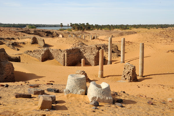
Gebel Barkal and the Sites of the Napatan Region. World Heritage Site. These five archaeological sites (Gebel Barkal, Kurru, Nuri, Sanam and Zuma) stretching over more than 60 km in the Nile valley, are testimony to the Napatan (900 to 270 BC) and Meroitic (270 BC to 350 AD) cultures, of the second kingdom of Kush. Tombs, with and without pyramids, temples, living complexes and palaces, are to be found on the site. Since Antiquity, the hill of Gebel Barkal has been strongly associated with religious traditions and folklore. The largest temples are still considered by the local people as sacred places.
They exhibit an architectural tradition that shaped the political, religious, social and artistic scene of the Middle and Northern Nile Valley for more than 2000 years (1500 BC- 6th Century AD). Gebel Barkal has been a sacred mountain since New Kingdom times (ca. 1500 BC). The Egyptians believed that their State God Amon resided in this “Holy Mountain”. Today, the mountain is locally named (Gebel Wad el-Karsani) after a Muslim sheikh (saint) buried near the 100m high, flat-topped sandstone rock.

Sitting just north of Gebel Barkal (I don’t know if one can go to the top) are the main set of pyramids – 5 intact and one mostly ruined. Each is elegantly made with precision-cut corner blocks on each of the four corners and about 40 rows of blocks between. They are all solid. To the east are 3 small ruined pyramids.
I continued to Meroe by taxi, expensive but the only way to get there from Gebel Barkal.
Archaeological Sites of the Island of Meroe WHS. A semi-desert island between the Nile and Atbara rivers, it was the heartland of the Kingdom of Kush, a major power from the 8th century B.C. to the 4th century A.D. The property consists of the royal city of the Kushite kings at Meroe, the capital, which includes the town and cemetery site, the nearby religious site of Naqa and Musawwarat es Sufra. It was the seat of the rulers who occupied Egypt for close to a century and features, among others, vestiges, pyramids, temples and domestic buildings. The water reservoirs are part of the hydrological regime in the area in the later centuries BCE and the first few centuries CE.. From the 3rd century BCE onwards it was the site of most royal burials. Their vast empire extended from the Mediterranean to the heart of Africa, and the property testifies to the exchange between the art, architecture, religions, and languages of both regions.

The city was conquered by the Aksumites around the year 330 CE producing the end of the Meroitic written and spoken language. The Aksumite invasion, coupled with the overuse of the land leading to desertification, led to the rapid decline of Meroe. The iron industry, requiring enormous amounts of wood, led to deforestation of the surrounding lands while cattle grazing and agriculture destroyed fields and depleted the soil. Meroe was eventually abandoned and, by the 5th century CE, had been transformed into a city of mystery and legend.
I arrived in Meroe, saw the archaeological site and left for Khartoum (420 km, 5 1/2 hours). This was a much more efficient day than Day 2. Buses are much better than share vans. This one had many empty seats and you get one all to yourself. The boss tells me I can’t sit sideways and rest my back against the window. He gets mad when I slap flies on the window. Then he sits on the seat next to me, so I move to the back. Other passengers tell me to close the curtain on the flies or to slap them with a cloth, not my hand. We listen to a constant stream of an Imam. At the Dongala turn-off, there are many selling fruit, candy bars, and dates and many get on.
OTHER DESTINATIONS in Northern State (not seen):
From Wadi Halfa, the road continues up the Nile and passes all the following Tentative WHS. I elected to not see them as each would have meant getting off the bus, finding local transport, and then another bus, simply too complicated.
Sai Island is a large island in the Nile River in Nubia between the second and third cataracts. It is 12 km long and 5.5 km wide. Saï was intermittently occupied by the Egyptians during the New Kingdom. In the Makurian period it was the center of a bishopric, while in the second half of the 16th century the Ottomans founded a fortress on the island.
The northeast portion of the island contains a New Kingdom of Egypt temple and numerous mills associated with ancient gold production. Nearby is an Ottoman Empire fort composed of sandstone quarried along the river banks, and spolia bearing the cartouche of Amenhotep IV, amongst other 18th Dynasty rulers. Numerous round tombs are close by.
The Temple of Soleb. Soleb is an ancient town in Nubia, in presen north of the third cataract of the Nile, Soleb has a vast necropolis with small tomb chapels decorated with pyramids. The earliest royal tombs date to the 18th dynasty, whereas some belong to the Ramesside and Meroitic periods. During the Amarna Period (Mid 18th Dynasty), several pharaohs attended to Soleb, such as Amenhotep III, Akhenaten, Tutankhamun, and Ay. A large temple made of sandstone was founded here by Amenhotep III. The temple was consecrated to the deity Amun Re and to the pharaoh depicted deified with ram horns.
The so-called Prudhoe Lions originally stood as guardian figures at this temple inscribed with the name of Amenhotep III. They depict a lioness, as a symbol of Sekhmet, a major deity who protected the pharaohs.

Monuments of the Kingdom of Kerma and Dokki Geil.
Kerma was the capital of the first Kingdom of Kush. Around 2500BC, one of the earliest urban centres in sub-Saharan Africa developed there and flourished between 2500 and 1500 BC and encompassed the area from the 1st to the 5th cataracts at its height. Kerma is located 45km north of the modern city of Dongola, The town of Kerma has well-developed architecture which included elaborate defences, an important religious quarter located at its heart, and countless domestic buildings, storage magazines, administrative and industrial complexes. The remains of the capital city surround the Western Deffufa, a large mud brick temple, 18m high, surrounded by the religious quarter. The settlement also contains a royal audience hall, palace and was partly fortified. The audience hall was a large round mud structure, which had been rebuilt several times in the same location and likely had a conical roof supported by three or four rows of wooden columns. Kerma had a rich material culture typified by extremely fine handmade pottery; a thin-walled red-polished ware with a black-topped rim as well as bronzes, ivories and faience. Products were traded from Egypt, Central Africa and shores of the Red Sea and seals and seal impressions testify these exchanges.
An extensive cemetery lies to the east of the town and contains royal burial tumuli, funerary chapels and temples, notably that of the Eastern Deffufa. The monuments of the Eastern and the Western Deffufas represent unique and outstanding examples of massive mudbrick buildings, which reflect the traditional architecture and technology at a significant stage in the history of Sudan in antiquity. Wealth and power were displayed in the royal tombs of the Kerma kings and in those of the nobility as may be demonstrated by the large number of associated cattle sacrifices. One tomb, perhaps of a king of the Middle Kerma period (2050–1750BC) consisted of a grave 11.7m in diameter and 2m deep, covered by a mound that reached 25m across. More than 4,000 cattle bucrania were arranged in a crescent shape on the south side of the mound. The tombs of the later Kerma kings were even more impressive. From 1700 BC, the Kingdom of Kush was the most powerful state in the Nile Valley. Buried under mounds up to 90m in diameter, these rulers were accompanied to their deaths by as many as 400 sacrificed humans, amongst whom may have been members of the king’s family, retainers, and prisoners of war, though their identities remain uncertain.
One kilometre north of the Nubian capital have preserved the remains of an extraordinary ceremonial city of Dokki Geil, which was founded by Egyptian pharaohs of Dynasty 18 after the destruction of Kerma (1750-1500 BC). It has oval or circular temples and palaces of surprising size. Palace A is 55 by 49 m, has a “forest” of 1400 columns supporting a huge roofing made of beams and palm fibres.
During the conquest of the territory by Thutmose I, a menenu is then established on the spot of the razed city of Dukki Gel. But then, the Nubian kings conquered Egypt, becoming the pharaohs of the 25th dynasty, after which the African kingdoms of Napata and Meroë develop.
See the museum near the ancient city of Kerma with seven restored monumental statues Dukki Gel, ceramic ware of the Kerma cultures, inscribed blocks of the Egyptian pharaohs of the New Kingdom, or daily life artefacts.
Kerma. Tentative WHS (01/09/1994). The capital city of the Kerma culture in ancient Nubia present at least 5500 years ago. . It has produced decades of extensive excavations and research, including thousands of graves and tombs and the residential quarters of the main city surrounding the Western/Lower Deffufa.
Around 3000 BC, a cultural tradition began around Kerma. It was a large urban center that was built around a large adobe temple known as the Western Deffufa. As a capital city and location of royal burials, it sheds light on the complex social structure present in this society.
By 1700 BC, Kerma had 10,000 people. Blue faience, which the Kermans developed techniques to work with independently of Egypt, and by their work with glazed quartzite and architectural inlays.
Kerma’s cemetery and royal tombs. 30,000 graves. The cemetery shows a general pattern of larger graves ringed by smaller ones, suggesting social stratification. The south has burial mounds and four extend to 90 metres in diameter, believed to be the graves of the city’s final kings. Influence from Egypt includes pottery and grave goods: Egyptian ceramics from Avaris, such as Tell el-Yahudiyeh Ware, scarab seals and amulets indicate extensive trade with ancient Egypt. After the sacking of Kerma, the cemetery was used to host the kings of the 25th or “Napatan” dynasty of the Kingdom of Kush from Upper (Southern) Nubia.
Al Khandaq Village is a town in northern Sudan on the River Nile, the site of an important fortress with beginnings dating to the Christian period. During the 19th century (Turkiyya) the town expanded much beyond the fortress to become one of the places with something like urban institutions in Northern Sudan, although it is now largely depopulated.
Once a thriving river port, was the residence of wealthy merchants who built two-storey houses of mud brick, with many rooms, as well as one-storey dwellings. These have been deserted since the early 1970s, when the trade declined. There are two mosques currently in use: al-Hassanab and al-Khatibiya. Public buildings include the police station (established in 1902), the rest house (established in 1905) and vestiges from the indigo industry. The fort, known as Qaila Qaila (which means “Red Fort”), dominates the town, The fort is in desperate need of support, especially the towers.
Al-Khandaq is situated about 423 km north of Khartoum on the left bank of the Nile. It was a primary port on the river between the 17th and 20th centuries connecting western Sudan with the river. The village was constructed on top of a medieval Christian fortress, but rapidly expanded beyond it. The site began to decline during the 1940s as the port faced increasing competition from the railway and road traffic as goods carriers.
Old Dongola. Tentative WHS (01/09/1994). A deserted town in the Northern State on the east bank of the Nile opposite the Wadi Howar. An important city in medieval Nubia, and the departure point for caravans west to Darfur and Kordofan, from the fourth to the fourteenth century Old Dongola was the capital of the Makurian state.
The urban center of the population moved downstream 80 km (50 miles) to the opposite side of the Nile during the nineteenth century, becoming the modern Dongola.
 The Church of the Granite Columns The Church of the Granite Columns |
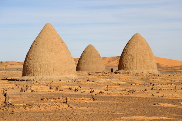
The archaeological site of 200 ha has a citadel, urban buildings, suburban residences, and cemeteries including Islamic domed tombs.
Old Dongola was founded in the fifth century as a fortress. The citadel was the royal residence. In the mid-sixth century with the arrival of Christianity it became the capital of Makuria,
 |
The Upper Church functioned from the mid-eleventh to the mid-eighteenth century.[3] It was a pilgrim center, as attested by almost 1,000 inscriptions left by visitors on the walls of the Raphaelion. They are written in Greek, Old Nubian, or a mixture of both. They mention a few Nubian kings and other prominent persons, such as a queen mother, which gives them historical importance.
Wadi Howar, one of the largest national park in the world. It has outstanding geological features including the volcanic and crater landscape of Meidob Hills, Jebel Rahib complex, etc. Numerous paleo lakes and large active barachen done fields also exist. The wadi was the largest Nile’s tributary from the Sahara between 9500 -3000 years before present. It flows into the Nile in old Dongola
Other Destinations
Badien Island (Jazeerat Dadeen) is one of the biggest islands in the Nile and the second biggest island in Sudan. It is 56 km to Dongola.
Lake Nasser. Vast reservoir in southern Egypt and northern Sudan, one of the largest man-made lakes in the world. Before construction, Sudan was against the building of Lake Nasser because it would encroach on land in the North, where the Nubian people lived. They would have to be resettled. In the end Sudan’s land near the area of Lake Nasser was mostly flooded by the lake. Strictly, “Lake Nasser” refers only to the much larger portion of the lake that is in Egyptian territory (83% of the total), with the Sudanese preferring to call their smaller body of water Lake Nubia
Mount Uwaynat area. Libya/Egypt/Sudan M@P – is a mountain range in the area of the Egyptian-Libyan-Sudanese tripoint. The area is notable for its prehistoric petroglyphs of Bushmen style are visible, representing lions, giraffes, ostriches, gazelles, cows and little human figures.
Mount Uwaynat lies about 40 km S-SE of Jabal Arkanu. The W foot is 618 m high and overcast with giant boulders fallen because of erosion.
The western part of the massif consists of intrusive granite, arranged in a ring shape of some 25 km in diameter.
The soldier riding next to me on the drive to Karima, says that the name of a large mountain to the west is Date Palm. .

Vestiges of the Past:
Sesibi Temple
Temple of Sedeinga
==============================================================
KHARTOUM & RIVER NILE STATE (Ad Damir)
Day 3 Tue Dec 20 (continued)
I took the bus from Meroe to Khartoum (10,000 SP). At the Dongala turnoff, the third full bus filled up almost completely.
As we approach Khartoum, the landscape changes to the Sahel, a flat desert with acacia trees. It is the dry season and no green grass is evident. We pass some tree plantations and green fields – there must be some irrigation.
It was a long tortuous drive through Omdurman letting off passengers and navigating traffic. They unloaded all but 4 passengers and all the freight (including about 100 boxes of dates) in the middle of Omdurman.
KHARTOUM/OMDURMAN (pop 5,274,321). The capital of Sudan, Khartoum is located at the confluence of the White Nile and the Blue Nile. Divided by these, Khartoum is a tripartite metropolis consisting of Khartoum proper, and linked by bridges to Khartoum North and Omdurman to the west.
Khartoum was founded in 1821 as part of Ottoman Egypt, north of the ancient city of Soba. The Siege of Khartoum in 1884 led to the capture of the city by Mahdist forces and a massacre of the defending Anglo-Egyptian garrison. It was reoccupied by British forces in 1898 and served as the seat of the Anglo-Egyptian Sudan government until 1956, when the city became the capital of an independent Sudan. The city has continued to experience unrest in modern times. Three hostages were killed during the Attack on the Saudi Embassy in Khartoum in 1973. The Justice and Equality Movement engaged in combat with Sudanese government forces in the city in 2008 as part of the War in Darfur. The Khartoum massacre occurred in 2019 amongst the Sudanese Revolution.
Khartoum is an economic and trade centre in Northern Africa, with rail lines from Port Sudan and El-Obeid. It is served by Khartoum International Airport, with another airport, Khartoum New International Airport, under construction.
Airports: Khartoum (KRT)
ON Sultan Hotel. 17,000. A large suite but filthy. Two other hotels had no space.
Day 4 Wed Dec 21
I went on a walkabout, also using shared vans and buses (200 SP). It took 2 hours to see 4 NM sites
Corinthia Hotel. In the NM Architectural Delights series, this is a beautiful modern structure shaped like a bee hive. There are 14 stories of rooms and a tapered top with glass on one side. Cannot enter if not a guest.
Tuti Bridge. A large yellow suspension bridge over the White Nile close to the Corinthia.
Greek Orthodox Cathedral. Two lovely square bell towers with clocks and a large dome. Surrounded by a 20′ wall and razor wire. Could not be entered.
Khartoum Grand Mosque. A lovely yellow stone building with an ornate stone minaret. Under construction, the main prayer area was in a covered area next to he mosque.
I didn’t see:
Ethnographic Museum
Al-Rikini Mosque
Saints Peter and Paul Catholic Church
Afra Mall
National Museum of Sudan
OMDURMAN*
Omdurman Bridge (White Nile Bridge)
Khalifa House Museum
Masjid Al-Nilin
Omdurman Souq
Flight Ethiopian Airlines ET345 KHT-Addis Ababa @11:25-2:30, 2′
I took a tuk-tuk to the airport, walked 3 blocks, and at check-in was advised that I had to register my visa. The building was a ways away, paid 500, filled out a form, printed my flight, endured delays, and finally received the small green sticker. Luckily they put it on my “Do Not Stamp This Page” page.
This airport has many deficiencies: no food, no duty-free, no BR at the gates.
==============================================================
RED SEA STATE (Port Sudan) NE of Khartoum along Red Sea
Getting to Port Sudan
Flights: Badr $94 everyday except Tuesday. Tarco check in office for prices and days.
Bus: Leaves 05:00 and arrives at 15:00. $15 on a bad road. There is a strange rule about needing to present her paperwork the previous day and have it checked.
Stay: Mona Mirak: $28 for a one bedroom apartment +249 90 148 9904
Sea Shell Resort for a out of town for diving and snorkelling.
Eco village all inclusive $90 per person. The food here is amazing and definitely been a highlight in Sudan +249 92 229 1616
Do: Eat fresh seafood near the port, snorkelling, diving, visit Suakin the coral island village, lighthouse at Sanganeb with some of the best snorkelling and diving here. Diving contact Mostafa: +249 91 224 1405. For more information about diving recommendations from Aniela Zaba https://www.facebook.com/groups/everypassportstamp/permalink/3174879042838619/
Permit: Required.
PORT SUDAN (pop 489,725 2007). The Republic of Sudan’s main seaport built in 1905 to replace Suakin. An oil pipeline was built between the port and Khartoum in 1977. The city has an oil refinery and handles the majority of the country’s international trade. Major exports include oilseed, senna, and hides and skins. Imports include construction materials, heavy machinery, and vehicles.
The city has a modern container-port to handle imports and exports. part of the 21st Century Maritime Silk Road that runs from the Chinese coast via the Suez Canal to the Mediterranean, there to the Upper Adriatic region of Trieste with its rail connections to Central and Eastern Europe.
There is now a rail link and tarred road linking Port Sudan to Khartoum. There is also an international ferry from Jeddah. Port Sudan has a hot desert climate with extremely hot summers and moderately hot winters, requiring the acquisition of fresh water from Wadi Arba’at in the Red Sea Hills and from salt-evaporating pans.
Port Sudan Airport (PZU)
Al Jazeera Mosque
Red Sea Aquarium
Port Sudan fish market
Sanganeb Marine National Park and Dungonab Bay – Mukkawar Island Marine National Park. World Heritage Site. Consists of two separate areas:
Sanganeb is an isolated, coral reef structure in the central Red Sea and the only atoll, 25 km off the shoreline of Sudan. Sanganeb atoll is the only atoll-like feature in the Red Sea, and a submerged and overhanging predator dominated coral reef ecosystem. It consists of 13 different bio-physiographic reef zones, each providing typical coral reef assemblages, supporting over 300 fish species, several endemic and rare species. Besides providing important nurseries and spawning grounds for key species, it also hosts resident populations of dolphins, sharks and marine turtles, which use the atoll as a resting, breeding and feeding area.
Dungonab Bay and Mukkawar Island, situated 125 km north of Port Sudan. It includes a highly diverse system of coral reefs, mangroves, seagrass beds, beaches, intertidal and mudflat areas, and islets – enable the survival (breeding, feeding and resting) of endangered habitat for seabirds, marine mammals, fish, sharks, turtles and manta rays. Dungonab Bay also has a globally significant population of dugongs. Located in the northern part of the Red Sea, the marine systems, fauna and flora are Indian Ocean origin but unique with different ecosystems and species. Seabirds (20 species), marine mammals (11 species), fish (300 species), corals (260 species), sharks, manta rays and marine turtles. It is an important larvae source area and hosts spawning sites for commercial fish species.
The two components of the property are connected by 125kms of coast with mersas, inlets, fringing reefs and off-shore reef formations, a large bay that contains islands, several small islets, clear visibility of the water and some of the most northerly coral reefs in the world associated with species (including seagrass and mangroves) at the limits of their global range and evolutionary expansion..
SUAKIN (pop 44,000 2011) Tentative WHS (01/09/1994). Suakin was a very important port on the west coast of the Red Sea during the Middle Age and the Ottoman Empire. It is now secondary to Port Sudan, about 50 kilometres (30 mi) north. Ferries run daily from Suakin to Jeddah in Saudi Arabia.
Suakin used to be considered the height of medieval luxury on the Red Sea, but the old city built of coral is now in ruins. It contains very fine houses and Mosques, some of them are partially preserved to the 2nd floor.
Suakin was likely Ptolemy’s Port of Good Hope but the Red Sea’s major port was Berenice to the north. The growth of the Muslim caliphate shifted trade first to the Hijaz and then the Persian Gulf. The Crusades and Mongol invasions drove more trade into the region. Despite the town’s formal submission to the Mamluks in 1317, the city remained a center of Christianity into the 13th century. Suakin was sieged by the Portuguese in 1513 and captured briefly in 1541.
Suakin was added to the Ottoman Empire in 1517. The Ottomans were unable to stop the Portuguese sea route around Africa and the local merchants began to abandon the town. By the 19th centuries, two-thirds of the homes were in ruins. In 186os Egypt built new houses, mills, mosques, hospitals, even a church for immigrant Copts.
The British were involved at Suakin in 1883–1885 but they preferred Port Sudan. By 1922, the last of the British had left. In 2018, Turkey obtained a 99-year lease over Suakin.
Climate. Suakin has a very hot desert climate with brutally hot and humid, though dry, summers and very warm winters. Rainfall is minimal.
Suakin Village
Suakin Archipelago NP. The largest group of islets on the Red Sea coast of Sudan, extending south-eastwards from Suakin almost to the Ethiopian border. There are 30 islets in the archipelago, all without fresh water and all uninhabited. Most of them are less than 1 km long, but two, Talla Talla Saghir and Talla Talla Kebir, are 5 km in length. Some of the larger, rocky islets, formed from raised coral reefs, reach a height of 10 m. All the islets are largely barren, with low vegetation growing only on the sandy fringes.
The islets support breeding colonies of five species of tern and four species of turtle have been reported to breed.
OTHER DESTINATIONS
Gulf of ‘Agig
Tokar Game Reserve. (Tawkar),is a town of 40,000 people near the Red Sea in northeastern Sudan. Tokar Game Reserve lies to the east of the town. In July, can reach 43 °C and the low is 20 °C. The town lies in the delta of the Baraka River. Since the 1860s cotton has been grown in the delta.
Bir Tawil. Egypt/disputed -. M@P, XL. Is a 2,060 km2 area of land along the border between Egypt and Sudan, which is uninhabited and claimed by neither country. When spoken of in association with the neighbouring Halaib Triangle, it is sometimes referred to as the Bir Tawil Triangle, despite the area’s quadrilateral shape; the two “triangles” border at a quadripoint.

Simplified map showing Egypt’s claim (yellow and green), the Sudan’s claim (blue and green), the Hala’ib Triangle (green) and Bir Tawil (the white area between Egypt and the Sudan). Its status results from a discrepancy between the straight political boundary between Egypt and the Sudan established in 1899, and the irregular administrative boundary established in 1902. Egypt asserts the political boundary, and the Sudan asserts the administrative boundary, with the result that the Hala’ib Triangle is claimed by both and Bir Tawil (which is only a tenth the size) by neither – the only place on Earth that was habitable but was not claimed by any recognised government, and has no permanent settlements or access to the sea.
Bir Tawil borders are north 95kms, south 46kms, east 26kms and west 49kms. Bir Tawil climate is a very hot desert climate with temperatures to 45 °C .
A number of individuals and organizations have attempted to claim Bir Tawil as a micronation. None have been recognized.
Hala’ib Triangle. Egypt/Sudan – M@P, XL. 20,580km2 on the coast of the Red Sea. The area, is created by the difference in the Egypt–Sudan border between the “political boundary” set in 1899 by the Anglo-Egyptian Condominium, which runs along the 22nd parallel north, and the “administrative boundary” set by the British in 1902, which gave administrative responsibility for an area of land north of the line to Sudan, which was an Anglo-Egyptian client at the time. With the independence of Sudan in 1956, both Egypt and the Sudan claimed sovereignty over the area. The area has been considered to be a part of the Sudan’s Red Sea State, and was included in local elections until the late 1980s. In 1994 the Egyptian military took control and Egypt has been actively investing in it since then. Egypt has been recently categorical in rejecting international arbitration or even political negotiations regarding the area.
The southern 290-kilometre border follows latitude 22° and the whole area is north of the 22-degree line, a smaller area south of latitude 22°, referred to as Bir Tawil, joins the Halaib Triangle at its westernmost point along the latitude line – neither Sudan nor Egypt claims Bir Tawil.
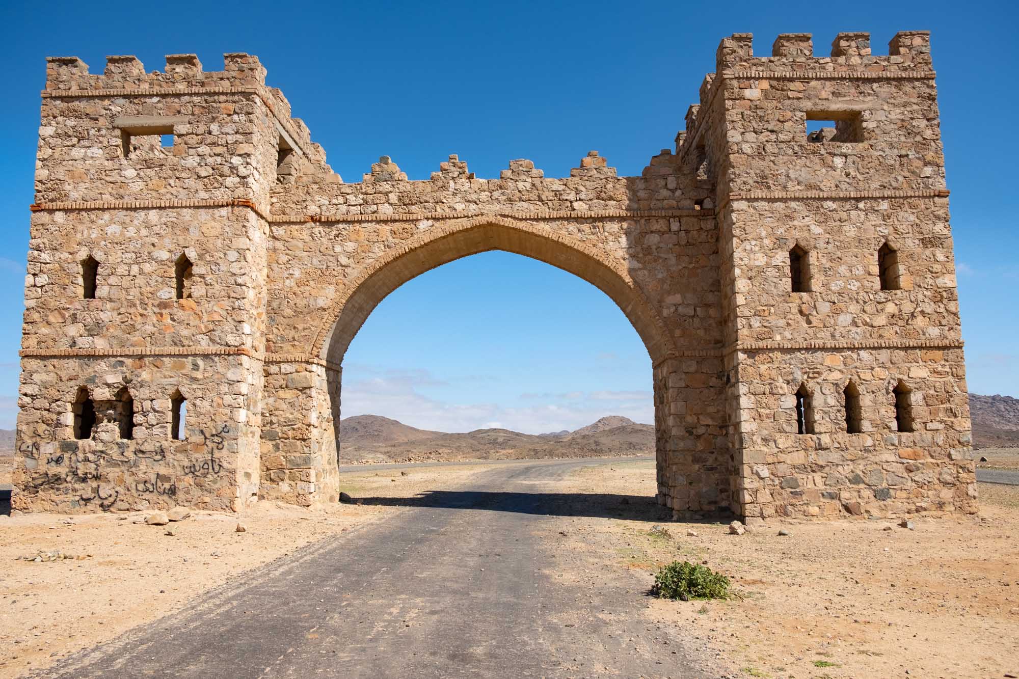
Arkawit. Village  located in the mountains near Port Sudan. Its welcoming marker is an enormous gate which straddles the road, literally in the middle of nowhere. 1,200 meters above the Red Sea, its clouds hug the buildings and rain is regular. Most people come to see the gate and then leave. Trek to the acacia-spotted ridges to see Sudan’s native monkeys. Mount Six has a small market called Harsab, orchards and gardens due to the rich soil and low cloud. You can stay at the resort of Jabel Alsit.
ENLARGE
KORDUFAN (El Obeid, Kadugli). A former province of central Sudan, in 1994 it was divided into three new federal states: north, south and west. Its area is 376,145 km² with an estimated population in 2000 of 3.6 million. It is largely an undulating plain, with the Nuba Mountains in the southeast quarter. During the rainy season from June to September, the area is fertile, but in the dry season, it is virtually desert. The region’s chief town is El-Obeid.
Traditionally the area is known for production of gum arabic. Other crops include groundnuts, cotton and millet. The main tribal groups are Arab. In Northern Kordofan there are large grazing areas used and inhabited for hundreds of years by Arabic-speaking, semi-nomadic people
Getting to El-Obeid
Flights: No flights as the road has been fixed and the bus is running.
Bus: Departs at 05:00, arrives at 15:00. $15.
Private cars when enough seats get sold. Reserve your ticket the night before.
Stay: Zanobia Hotel on the outskirts near the empty dam. Clean, ask for towels, AC, hot water. $30-$40 twin. UN workers stay here.
Do: Eat Agashi – local cheese, visit the many cafes, track down the local band Roots and you may get an invite to band practice night, just outside town are Kordufan mountains , Reservoir (was dry when we went), visit a weird home museum of a local collector that was amazingly bizarre, visit the tourist village outside town about an hour and a half for a nice afternoon by the lake, visit the football stadium. Without a local contact many of these activities may prove to be difficult.
Tour – Hassan: +249 11 969 8890
Permit: Required
UBAYYID (pop 340,940.2008). El-Obeid is the capital of the state of North Kurdufan. Founded by the Ottomans in 1821, it is an important transportation hub: the terminus of a rail line, the junction of various national roads and camel caravan routes, and the end of a pilgrim route from Nigeria. Products such as gum arabic, millet, oilseeds, and livestock, an airport, an oil refinery and home to the University of Kordofan,
The population is majority Muslim, with a small Christian presence. Khartoum is 500 kms and takes about nine hours.
El-Obeid has a hot arid climate despite receiving over 300 millimetres or 12 inches of rain, owing to the extremely high potential evapotranspiration.
A safe. small nice town with few attractions but a good cultural experience.
Great White Mosque
Our Lady Queen of Africa Cathedral. One of the largest and oldest churches in Sudan founded in 1872. The present building was constructed between 1961 and 1964 in Italian style.
OTHER DESTINATIONS
Jebel Al Dair National Park Tentative WHS in the South Eastern corner of Northern Kordofan State with an area of 615.460 km², falls within the northern limits of the dry savannah woodland – grassland. Its annual rainfall ranges between 250 mm and 600 mm starting at late May with a peak in August and diminishes towards the end of October. Jebel AL Dair, as the name designates, appears from a distance as a group of mountain tops, clustering in a circular form, with several peaks of varying heights, some of which rise up to over 1400 m. above sea level. The park contains a variety of habitats in four distinct biophysical environments with their specific fauna and flora, including the higher elevation slopes and escarpments (at 900 to 1424 m), Fawas or enclosed flat plains between the grouping humps and peaks of the massif (at 900- 1200 m), upland valleys and streams (at 800-1200 m and the lower slopes down the foot hills (at 500-800 m).
It occupies a prominent economic position as one of the most important sources of woody materials needed for several uses.
Kaduqli
Nahud
Abyei. M@P, XL. A border town in the centre of the oil-producing and fertile Abyei Area It is a disputed territorial point of contention in the July 2011 secession of South Sudan process. It had a population at around 20,000 previous to May 2011 events.
Abyei town was almost completely destroyed in May 2008 when tensions escalated between the Sudan People’s Liberation Army/Movement (SPLA) and the Sudanese Armed Forces (SAF) after the Government of South Sudan appointed an administrator for the region, a move the Messiria objected to. In 2009, 50,000 of Abyei Town’s inhabitants, mostly Dinka fled southwards to Agok in Southern Sudan. Much of the town was rebuilt by mid-2009. The northern Sudan military in 2011 did a forceful takeover of Abyei Area and town. The Sudanese army burned and razed about one-third of all civilian buildings in the town. Tens of thousands of Abyei region civilians, including up to 35,000 children, have been displaced by the northern takeover.
==============================================================
KASSALA & AL QADARIF (SE of Khartoum)
Getting to Kassala:
Flights: Badr $72 one way on Tue, Thu, Sat, Sun. Tarco can’t book online.
Bus: Arrive at 04:30 and leave at 06:30. Arrives at 16:00. $15.
Stay: Hipton nicest with running water, generator and AC. Restaurant not open.
Do. Connect with locals or just use taxis, climb Taka mountain with loads of water, tea village at Jebel Totil, drink chai and jebena, watch sunset. Visit Seyyid Hassan Tomb and Mosque. Souq. Beja tribe has swords. Rashaida tribe smuggle anything, Groves outside town for fruit from the tree and experience some “farm life”
Permit: Required
KASSALA (pop 419,030 2008). The capital of the state of Kassala in eastern Sudan, it is on the banks of the Gash River, a market town and is famous for its fruit gardens. Many of its inhabitants are from the Beni-Amer group.
The town was formerly a railroad hub until 2006. Kassala’s location along the main Khartoum-Port Sudan highway makes it an important trade center. The city is home to Kassala University, a public university established in 1990 to replace the East University, and an important institution for development in the east of Sudan.
Khatmiya Mosque. Built in 1840 by the Ottomans and damaged during the Mahdist War, is the city’s most important cultural site. It is an important site for the Sufi Khatmiyya order.
Kassala Souq.
Dinder National Park. Tentative WHS (28/09/2004). In eastern Sudan, and is connected to Ethiopia’s Alatash National Park. 400 kilometres southeast of Khartoum, on either side of the Dinder River. The town of Dinder (100 kilometres (62 mi) northwest) acts as a gateway for tourists wishing to enter the Park.
The area of Dinder was heavily populated when it was first visited by Europeans in 1861. In the 1880s, during the Mahdist War and famine, the human population vanished.
It is ecologically significant because it falls on the ecotone between the Sahel and Ethiopian Highlands ecoregions. It contains three distinct ecosystems: riverine, woodland and oxbow lake.
The park is home to 27 species of large mammals such as lion, leopard, cheetah and the painted hunting dog, more than 160 bird species including North African ostrich, 32 fish species, and small mammals, bats, reptiles, and amphibians. It is in a major flyway used by birds migrating between Eurasia and Africa.
It is threatened from cattle herders who are being displaced from their traditional grazing lands by the expansion of crop agriculture. Game counts between 1971 and 2001 have shown a precipitous decline in most large mammal species, with the population of waterbuck falling by 85%, reedbuck by 72%, and oribi by 68%.
Wadi Howar National Park. Tentative WHS (28/09/2004). In south eastern Sahars, 100 thousand km sq. and one of the largest national park in the world. Diverse flora and outstanding geological features including the volcanic and crater landscape of Meidob Hills, Jebel Rahib complex …. etc. Numerous paleo lakes and large active barachen done fields also exist. Dorcas gazelle, barberg shepp, ostrich. It ordinarily receives 25 mm of rainfall per year
Wadi Howar is the remnant of the ancient Yellow Nile, a tributary of the Nile during the Neolithic Subpluvial from about 9500 to 4500 years ago. At that time Savanna fauna and cattle-herders occupied this region and the southern edge of the Sahara was some 500 km further north than it is today. When the Sahara underwent desertification between 6000 and 4000 years ago, the wadi first became a chain of freshwater lakes and marshes, as shown by Ptolemy’s world map, then it became extinct about 2000 years ago.
Rahad Game Reserve. (no info available)
Qadarif
Rivers
Atbarah River
Dinder River
Mareb River
Rahad River
Rahad/Shinfa River
Tekkeze/Setit River
==============================================================
DARFUR (Nyala)
Darfur was an independent sultanate for several hundred years until it was incorporated into Sudan by Anglo-Egyptian forces in 1916. Because of the War in Darfur between Sudanese government forces and the indigenous population, the region has been in a state of humanitarian emergency since 2003.
Darfur covers an area of 493,180km2, the size of mainland Spain. It is largely a semi-arid plateau with the Marrah Mountains (Jebel Marra), a range of volcanic peaks rising up to 3,042 meters (9,980 ft) of topographic prominence, in the center of the region. The region’s main towns are Al Fashir, Geneina, and Nyala.
Most of the region consists of a semi-arid plain with the Marrah Mountains offer plentiful water,
A pattern of skewed economic development continued after Sudan achieved political independence in 1956. The proxy wars between Sudan, Libya and Chad added an element of political instability. Darfurians, mainly those who self-identified as “Arab” and “African” people, began to respond to the ideology of Arab supremacy propagated by Libyan leader Muammar al-Gaddafi (in power 1969-2011). A famine in the mid-1980s disrupted many societal structures and led to the first significant modern fighting amongst Darfuris. A low-level conflict continued for the next fifteen years, with the government co-opting and arming Arab Janjaweed militias against its enemies. The fighting reached a peak in 2003 with the beginning of the Darfur conflict, in which the resistance coalesced into a roughly cohesive rebel movement. Human-rights groups and the UN, March, 2004, came to regard the conflict as one of the worst humanitarian disasters in the world. Insurgency and counter-insurgency have led to 480,000 deaths (the Khartoum government disputes the numbers). This has been labeled as Darfur genocide. “By 2010 about 300,000 had died, according to the UN best estimate and about 3,000,000 were forced into refugee camps” Over 2.8 million people have become displaced since 2003, many of whom were children. Many of these refugees have gone into camps where emergency aid has created conditions that, although extremely basic, are better than in the villages, which offer no protection against the various militias that operate in the region.
Nearly two-thirds of the population continues to struggle to survive in remote villages. Virtually no foreigners visit the region because of the fear of kidnapping, and only some non-governmental organizations continue to provide long-term grass-roots assistance. The Darfur Peace Agreement of 2006 was signed by only one rebel group. In 2010, an umbrella organisation of ten rebel groups started a fresh round of talks with the Sudanese Government in Doha, Qatar.
A comprehensive peace agreement was signed on 31 August 2020 in Juba, South Sudan, between the Sudanese authorities and rebel factions to end armed hostilities.
In comparison to other cities this is the most expensive one. Be willing to spend $800 at least to get here and experience something especially on your own.
Getting to Nyala:
Flights: $115 one way with Badr (Mon,Thu,Fri,Sat)
Bus: 2 days from Khartoum but not a safe options
Stay: Staying at AlDaman hotel $100/night. Cheaper options available.
Do: Visit Jebel Marra Cost 100000SDG – $170 day trip.
Permit: Obtain from the head of Khartoum police. Can book flights without this but not able get a boarding pass without it.
NYALA is the capital of South Darfur in the south-west of Sudan, the best place for water and land topography in the area. During the ongoing Darfur conflict, thousands of internally displaced persons have gathered in Kalma refugee camp near the city in the hopes of protection. 90,000 people reside in the camp.
Industries include textiles, processed food and leather goods. Terminus ends for both road and railway, a trading place for gum arabic and home to Nyala University
Nyala suffers from severe water infrastructure problems caused by droughts and poor water management, including poor source treatment and delivery methods. Most of the water used in and around Nyala is ground water; this is heavily contaminated due to human activity, bearing the consequences of inadequate waste management and lack of proper sanitation. Water resources in the city have tested to contain bacteria levels higher than permissible amounts, which in turn creates health issues. In many cases the water collected for distribution is not properly chlorinated, allowing further increase in bacteria levels.
The schools’ staff is underpaid and unqualified for adequate teaching as the government often does not commit to their financial responsibility. Many children do not attend school so they can work.
Climate. 16 inches of rainfall annually, Nyala has a marginal hot desert climate owing to the extremely high potential evapotranspiration.
Amel Center is a treatment and rehabilitation center in Nyala for victims of torture.
OTHER DESTINATIONS
Tentative WHS
Al Radom National Park
Jebel Marra / Deriba Caldera (crater lake)
AL-FASHIR (pop 265,000) The capital city of North Darfur 195 kilometres northeast of Nyala. A historical caravan post, 700 metres. The town serves as an agricultural marketing point for the cereals and fruits grown in the surrounding region. Al-Fashir is linked by road with both Geneina and Umm Keddada.
Due to the nearby Abu Shouk and Al Salam IDP camps with the influx of humanitarian aid from the United Nations as a result of the Darfur crisis, the city has experienced a significant economic and population boom. Rents and retail sales increased, including the selling of bottled water and the opening of a pizza parlor to cater to the demand from western aid workers. The number of gas stations has tripled in three years as a result of the increase in the amount of automobiles in the city. Employment opportunities also increased as the United Nations offered jobs to citizens. Economics analyst Adam Ahmed stated that the “people [of Al-Fashir] are beginning to think in a more business-minded way” to make the most of their situation.
Al Fashir University was created in 1990.
Al-Fashir Airport (ELF)
DAEIN
GENEINA
West Darfur state (Geneina).
Merga Oasis (Northern Darfur). XL
Western Darfur province. M@P, XL
Radom NP
========================================================
AL JAZIRAH, WHITE NILE, SENNAR, BLUE NILE (Wad, Sennar)
The state lies between the Blue Nile and the White Nile in the east-central region of the country. It has an area of 27,549 km2. Gezira is known as an irrigated cotton-producing state suitable for agriculture.
Cotton is possible because of the Sennar Dam and irrigation canals and it became the Sudan’s major agricultural region with more than 10,000 square kilometres (2.5×10⁶ acres) under cultivation. Wheat has supplanted a third of the land formerly seeded with cotton.
Blue Nile. Originating at Lake Tana in Ethiopia, it runs for 1,450 km (900 mi) through Ethiopia (800kms inside Ethiopia) and Sudan. Along with the White Nile, it is one of the two major tributaries of the Nile, and supplies about 80% of the water in the Nile during the rainy season.
From Lake Tana, it flows generally south for 30kms before entering a canyon about 400 km (250 mi) long, a tremendous obstacle for travel and communication between north and south Ethiopia. The canyon was first referred to as the “Grand Canyon” in 1968. The Blue Nile Falls one of Ethiopia’s biggest tourist attractions, is located at the start of the canyon..
In 2012, Ethiopia began construction of the Grand Ethiopian Renaissance Dam, a 6000-megawatt hydroelectric dam on the river. The dam is expected to be a boost for the Ethiopian economy. Sudan and Egypt, however, voiced their concerns over a potential reduction in water available.
The river is also an important resource for Sudan, where the Roseires Dam and Sennar Dams produce 80% of the country’s power. These dams also help irrigate the Gezira Scheme, which is most famous for its high-quality cotton, as well as wheat and animal feed crop production in the area.
White Nile. One of the two main tributaries of the Nile, the name comes from colouring due to clay carried in the water. Strictly, “White Nile” refers to the river formed at Lake No, at the confluence of the Bahr al Jabal and Bahr el Ghazal Rivers. In the wider sense, “White Nile” refers to all the stretches of river draining from Lake Victoria through to the merger with the Blue Nile. These higher stretches being named the “Victoria Nile” (via Lake Kyoga to Lake Albert), the “Albert Nile” (to the South Sudan border) and then the “Mountain Nile” or “Bahr-al-Jabal” (down to Lake No). “White Nile” may sometimes include the headwaters of Lake Victoria, the most remote of which being 3,700 kilometres (2,300 mi) from the Blue Nile.

Headwaters: The Kagera River, which flows into Lake Victoria near the Tanzanian town of Bukoba, is the longest feeder river for Lake Victoria, although sources do not agree on which is the longest tributary of the Kagera, either the Ruvyironza in Burundi,[8] near Bukirasaz or the Nyabarongo from Nyungwe Forest in Rwanda. These two feeder rivers meet near Rusumo Falls on the border between Rwanda and Tanzania. The Kagera forms part of the Rwanda–Tanzania and Tanzania–Uganda borders before flowing into Lake Victoria.
Just before entering Lake Albert, the river is compressed into a passage just seven meters wide at Murchison Falls, marking its entry into the western branch of the East African Rift. The river then flows into Lake Albert opposite the Blue Mountains in the Democratic Republic of the Congo.
In Sudan the river lends its name to the Sudanese state of White Nile, before merging with the larger Blue Nile at Khartoum, the capital of Sudan, and forming the River Nile. The White Nile is a navigable waterway from the Lake Albert to Khartoum through Jebel Aulia Dam, only between Juba and Uganda requires the river upgrade or channel to make it navigable. During part of the year the rivers are navigable up to Gambela, Ethiopia, and Wau, South Sudan.
Sabaloka Game Reserve. Established in 1946, it is 1160 km2. Due to the change of climatic conditions, excessive deforestation and hunting of wild animals, the living conditions have changed greatly as many animals have disappeared, and many are threatened with extinction.
M@P Sudan – Blue Nile state
Islands: Aba
Damzin
Dueim
Kosti
Managil
Rabak
Sennar
Wad Madani
Rahad/Shinfa River
Bertas: Indigenous Peoples: