
CANADA – MANITOBA SOUTH (Winnipeg, Brandon)
Pimachiowin Aki (‘The Land That Gives Life’) is a landscape of rivers, lakes, wetlands, and boreal forest. It forms part of the ancestral home of the Anishinaabeg, an indigenous people living from fishing, hunting and gathering. The site encompasses the traditional lands of four Anishinaabeg communities (Bloodvein River, Little Grand Rapids, Pauingassi and Poplar River) and extends to 2,904,000 hectares. It encompasses slightly less than a quarter of the lands occupied by Anishinaabe peoples.
It is an exceptional example of the cultural tradition of Ji-ganawendamang Gidakiiminaan (‘keeping the land’), which consists of honouring the gifts of the Creator, respecting all forms of life, and maintaining harmonious relations with others. A complex network of livelihood sites, habitation sites, travel routes and ceremonial sites, often linked by waterways, provides testimony to this ancient and continuing tradition.
Ancient and contemporary livelihood sites, habitations and processing sites, travel routes, named places, and trap lines, widely dispersed across the landscape, while being sacred and ceremonial sites, reflect how they and their Indigenous ancestors have used this and adjacent landscapes for over 7,000 years.
Pimachiowin Aki is a vast area of healthy boreal forest, wetlands, lakes, and free-flowing rivers. Waterways provide ecological connectivity across the entire landscape. Wildfire, nutrient flow, species movements, and predator-prey relationships are key, naturally functioning ecological processes that maintain an impressive mosaic of ecosystems. These ecosystems support an outstanding community of boreal plants and animals, including iconic species such as Woodland Caribou, Moose, Wolf, Wolverine, Lake Sturgeon, Leopard Frog, Loon and Canada Warbler. Notable predator-prey relationships are sustained among species such as the Wolf, Moose, Woodland Caribou, and the Lynx and Snowshoe Hare. Traditional use by Anishinaabeg, including sustainable fishing, hunting and trapping, is also an integral part of the boreal ecosystems in Pimachiowin Aki.
The whole property is protected from commercial logging, mining, and hydroelectric development, and all its waterways are free of dams and diversions.
STEINBACH (pop 15,829) is located about 58 km southeast of Winnipeg. Steinbach (translated from German as “Stony Brook”) was first settled by Plautdietsch-speaking Mennonites from the Russian Empire in 1874, whose descendants continue to have a significant presence in the city today. Steinbach is found on the eastern edge of the Canadian Prairies, while Sandilands Provincial Forest is a short distance east of the city.
Steinbach is primarily an agricultural community; however, as the regional economic hub of southeastern Manitoba, Steinbach has a trading area population of about 50,000 people. The city has gained national recognition as a Canadian immigration destination and a model for immigrant integration.
Mennonite Heritage Village tells the story of the Russian Mennonites in Canada. The museum contains both an outdoor open-air museum that is open seasonally and an indoor building that is open year-round. It opened in 1967 and has expanded significantly, making it a major tourist attraction Approximately 47,000 visitors visit the museum each year. The village features original Mennonite housebarns, churches, and other buildings, some dating back to the 1800s. The indoor facility documents the history of Mennonites from their origins in the Netherlands and Switzerland and focuses on the Plautdietsch-speaking Russian Mennonites who came to Western Canada.
The museum is famous for its Dutch windmill, a replica of the original built in Steinbach in the 1880s. The first replica was burned down by arsonists in 2000, but was later rebuilt. The outdoor village also displays a section of the Berlin Wall, the original sawmill used by Mennonite Conscientious Objectors during their Alternative Service in World War II.
Steinbach Windmill. Mennonites learned how to harness the wind while in the Netherlands, and used this knowledge in the 16th and 17th centuries in Prussia, wind-powered mills were primarily used to pump water to drain land. Between 1876 and ’78, four windmills were built in the Steinbach, Man., area by Mennonites. This one was built in 1877 and moved in 1879 to nearby Rosenort, with more favourable winds. The mill was taken down in 1920 once gas-powered mills took over from wind power. Windmills, like grain elevators, became iconic symbols on the Prairies.
Immaculate Conception Church, Cook’s Creek. Known as the “Prairie Cathedral” and located in a rural area northeast of Winnipeg, this imposing Ukrainian Catholic church was built between 1930 and 1952. The elaborate exterior has 10 green fluted columns on the portico, green cross tiles, and marble arched windows. The inside has elaborate painted walls.
The Ukrainian Baroque-style church was almost entirely hand-built by volunteers (including Father Ruh), and local artisans painted the elaborate interior, nine domes, with the largest at the crossing and four smaller domes set on square towers. The stucco was painted in polychromatic faux finishing (bright yellow, light blue, and white), and Romanesque elements such as columns, pilasters, round-arched blind arcades, entablatures, belt courses, etc.
The entrance porch features three sets of wooden doors with fanlights, Tuscan columns, a grand staircase, and many round-arched openings throughout, some with coloured glass and decorative surrounds, found in pairs or triples on the upper levels.
The grounds contain a free-standing bell tower, the Grotto of Our Lady of Lourdes and the cemetery.

WINNIPEG (pop 778,000) is the capital and largest city of Manitoba and is centred on the confluence of the Red and Assiniboine rivers, near the longitudinal centre of North America. The city is named after the nearby Lake Winnipeg; the name comes from the Western Cree words for muddy water.
The region was a trading centre for Indigenous peoples long before the arrival of Europeans. French traders built the first fort on the site in 1738. A settlement was later founded by the Selkirk settlers of the Red River Colony in 1812, the nucleus of which was incorporated as the City of Winnipeg in 1873. As of 2016, Winnipeg is the seventh-most populated municipality in Canada. Being far inland, the local climate is extremely seasonal even by Canadian standards, with average January lows of around −21 °C (−6 6°F) and average July highs of 26 °C (79°F).
Known as the “Gateway to the West”, Winnipeg is a railway and transportation hub with a diversified economy. This multicultural city hosts numerous annual festivals, including the Festival du Voyageur, the Winnipeg Folk Festival, the Jazz Winnipeg Festival, the Winnipeg Fringe Theatre Festival, and Folklorama. It is home to several professional sports franchises, including the Winnipeg Blue Bombers (Canadian football), the Winnipeg Jets (ice hockey), the Manitoba Moose (ice hockey), Valour FC (soccer), and the Winnipeg Goldeyes (baseball).
Fort Gibraltar was founded in 1809 by the North West Company at the confluence of the Red and Assiniboine rivers in or near the area now known as The Forks in Winnipeg. Fort Gibraltar was renamed Fort Garry after the merger of the North West Company and the Hudson’s Bay Company in 1821.
In the early 19th century, fur-trading was the primary industry of Western Canada. Two companies had an intense competition over the trade. The Hudson’s Bay Company was the first London, England-based organization. The second, the North West Company, was based in Montreal. Hudson’s Bay Company was distinctly English in its culture and flavour, while the North West Company was a mix of French, Scottish and First Nations cultures. The voyageurs of the North West Company were a highly mobile group of fur traders. They established temporary encampments in the Forks region that later became Winnipeg.
In 1809, the North West Company built Fort Gibraltar. About half a mile north, the HBC built Fort Douglas between 1813 and 15, and there were many conflicts between the HBC’s mostly Scottish employees and the NWC’s mostly French-Canadians and Métis employees. On March 26, 1821, the North West Company was merged with its rival under the Hudson’s Bay Company name.
A reconstructed Fort Gibraltar in St. Boniface was built in the late 1970s for the Festival du Voyageur, the largest winter festival in Western Canada. In the summer, the museum operates living history demonstrations of life in the fur trading post as it was in 1815. Fort Gibraltar is currently located in Whittier Park at 866 St Joseph Street.
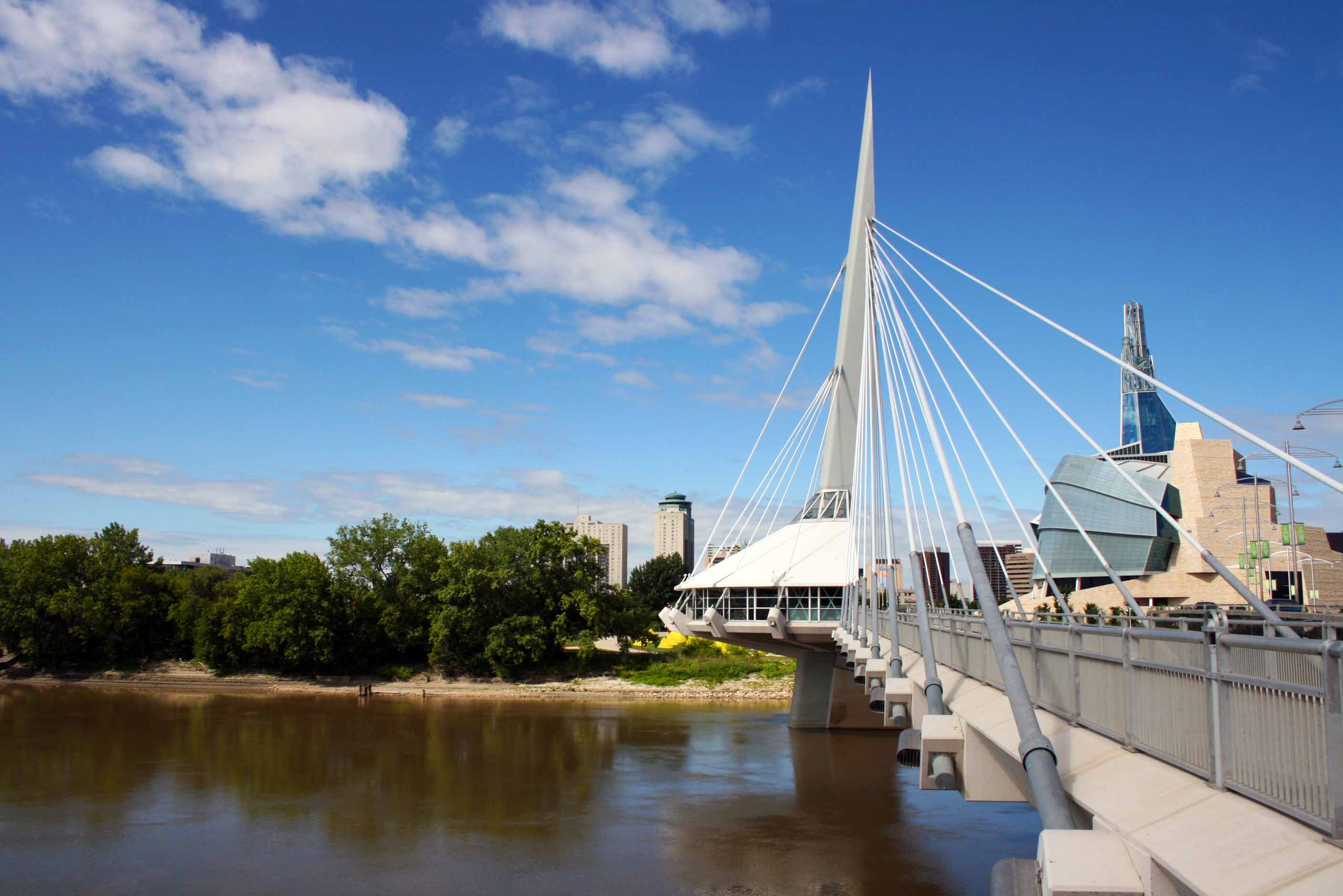
Esplanade Riel is a pedestrian bridge built in 2003 and named in honour of Louis Riel. It is a side-spar cable-stayed bridge which spans the Red River connecting downtown Winnipeg with St. Boniface; it is paired with the Provencher Bridge, a new four-lane divided vehicular bridge. The bridge includes an architectural composite tower prestressed with a cantilevered and stayed semi-circular plaza area at the tower’s base. The plaza gives this the only bridge with a restaurant in North America. The space has three restaurants, but it is presently closed.
Holy Trinity Anglican Church. Erected in 1883-1884 on the north side of Graham Avenue between Donald and Smith streets, this picturesque limestone structure is a fine example of the High Victorian Gothic style using dormer clerestory windows, buttresses, finials and hammer beam ceiling. The irregular outline, with attached parish hall and bell tower, recalls English parish churches. This church is the fourth to serve the parish since its incorporation in 1868. Set within a landscaped churchyard, Holy Trinity is a landmark in the heart of Winnipeg.
Located on the interior south wall of the sanctuary are two bronze plaques commemorating the members of the Fort Garry Horse (FGH) who died in service of their country during the First and Second World Wars.

Polo Park is a shopping centre on the former Polo Park Racetrack near Portage Avenue and St. James Street. The largest mall of the eight malls in the city, it is the 15th largest shopping centre. It opened in 1959 AI became one of Canada’s first enclosed shopping malls when a roof was added in 1963. Expansions were made in 1968, 1986, 2007, and 2014.
Fort Garry Hotel is a historic hotel in downtown Winnipeg that opened for the first time in 1913 as one of Canada’s grand railway hotels. A national heritage park connected to the hotel and Upper Fort Garry’s remains was completed in 2017-18.
Built in 1913 by the Grand Trunk Pacific Railway, it is located one block from the railway’s Union Station, and was the tallest structure in the city when it was completed. Like other Canadian railway hotels, it was constructed in the “château style”.
The hotel’s early prominence led to many famous guests, including Nelson Eddy, Harry Belafonte, Charles Laughton, Laurence Olivier, Liberace, Arthur Fiedler, Louis Armstrong, Gordie Howe, and Lester Pearson, as well as King George VI and Queen Elizabeth, who stayed during their 1939 visit to Canada.
Later, it was owned by the Canadian National Railway and other private investors.
According to local folklore, the hotel is haunted. The Fort Garry Hotel is infamous for its haunted Room 202. A woman committed suicide in the room many years ago after hearing of the death of her husband in a car accident. Overcome with grief, she hanged herself in the closet.
Le Marché St. Norbert Farmers’ Market is Manitoba’s most prominent and best-known market. The outdoor markets run on Saturdays from 8 to 3 and Wednesdays from 11 to 3 from Victoria Day until Thanksgiving. Featured weekly at the market are 130 full-time vendors and as many as 50 casual vendors selling locally grown produce, delicious fresh baking, homestyle jams and preserves, homespun crafts, jewelry, flowers, and much more.
++++++++++++++++++++++++++++++++++++++++++++++++++++++++++++++
CANADA – SASKATCHEWAN (Regina, Saskatoon)
On June 12, I crossed from Manitoba into my province of birth. I was born in Assiniboia and lived in Scout Lake and Glentworth until age 7, when we moved to Medicine Hat, Alberta.
I hope to see some of my cousins who still live in the Assiniboia area.
++++++++++++++++++++++++++++++++++++++++++++++++++++++++
CANADA – ALBERTA SOUTH (Calgary, Lethbridge, Medicine Hat)
After visiting relatives in the Assiniboia and Shaunavon area, I continued to Alberta and Calgary to see more cousins.
Red Rock Coulee
Etzidom Windmill.
VULCAN
With a population of around 2,000, Vulcan reportedly was initially named for the Roman god. In the nineties (?), a new tourism initiative capitalized on the popularity of Star Trek, and the town embraced a new sci-fi aesthetic. Vulcan now celebrates with a yearly fair, Spock Days, every June, and hosts an annual Vulcan Star Trek convention called Vul-Con. Leonard Nimoy visited the town in 2010, so you know they’ve got something special going on.
Star Trek Mural
CALGARY (pop 1,285,711)
Situated at the confluence of the Bow River and the Elbow River in the south of the province, in an area of foothills and prairie, about 80 km (50 mi) east of the front ranges of the Canadian Rockies, roughly 299 km (186 mi) south of the provincial capital of Edmonton and approximately 240 km (150 mi) north of the Canada–United States border, it is Alberta’s largest city and the third-largest municipality in Canada (after Toronto and Montreal), and the largest in western Canada.
Calgary’s economy includes activity in the energy, financial services, film and television, transportation and logistics, technology, manufacturing, aerospace, health and wellness, retail, and tourism sectors. The Calgary Metropolitan Region is home to Canada’s second-highest concentration of corporate head offices among the country’s 800 largest corporations. In 2015, Calgary had the highest number of millionaires per capita of any major Canadian city. I1n 1988, I ecame the first Canadian city to host the Winter Olympic Games.
Heritage Park Historical Village is a historical park opened in 1964 in Calgary on 127 acres (51 ha) of parkland on the banks of the Glenmore Reservoir, along the city’s southwestern edge. Exhibits span western Canadian history from the 1860s to the 1950s. Many of the buildings are historical and were transported to the park to be placed on display. Others are recreations of actual buildings. Most of the structures are furnished and decorated with genuine artifacts. Staff dressed in historic costumes, antique automobiles, and horse-drawn vehicles serve the site.
The Park has two operating seasons: the Historical Village is open from May to October; the Gasoline Alley Museum is open year-round. The park is divided into four distinct areas reflecting different periods in Western Canadian history: the Hudson’s Bay Company Fur Trading Fort, c. 1864; the Pre-Railway Settlement Village, c. 1880; the Railway Prairie Town, c. 1910; and the newly opened (2009) Heritage Town Square, depicting the 1920s to 1950s.
One hundred exhibits including a passenger train, roundhouse built in 1981, streetcar from Calgary’s former streetcar system, re-creation of a paddle steamer, S.S. Moyie, that traverses the Glenmore Reservoir, antique midway that features working historical amusement park rides, aboriginal encampment representing the First Peoples in southern Alberta in the 19th century, working smithy, bakery, hotel, and several shops and restaurants, horse-drawn wagons, Hudson’s Bay Company trading fort, 1913 Little Synagogue on the Prairie and the Town Square, located in front of the park gates, contains Haskayne Mercantile Block, Selkirk Grille and Big Rock Interpretive Brewery flanked by the Bissett Wetlands. Admission is free in this area of the park.
Bruderheim Windmill. Located in the southeast corner of Heritage Park with a great view of Glenmore Reservoir.
Newcomers to Western Canada were dismayed by the scarcity and cost of flour. Those with a millwright’s skills often ground wheat or rye for the community. This was the case for Wilhelm Mallon, who built this windmill in 1920 in the Bruderheim district near Edmonton.
Mallon used only materials at hand. Local timber provided the framework. The gears, wheels and shafts were made from scrub birch. Paraffin wax was used to lubricate all moving parts. There was not a single piece of metal in the original millworks.
Mallon’s mill turned out 150 pounds of flour daily if the winds were right. As was the custom, the miller kept a portion of each run to pay for his services.
Crossroads Market. This large market in SW Calgary has an enclosed space and outdoor vendors. Open Friday, Sat and Sunday.
Fort Calgary
Central Library.
 The
The
Bow is a 158,000-square-metre office building for Encana Corporation and Cenovus Energy’s headquarters in downtown Calgary. The 236 metre (774 ft) building is currently the second-tallest office tower in Calgary, since the construction of Brookfield Place, and the third-tallest in Canada outside Toronto. 58 stories, two retail floors, three floors – sky gardens, spaced approximately every 18 floors (sky lobbies), served by express elevators, 53 office floors, +15 skywalk connections to neighbouring buildings.
The Bow is also considered the start of redevelopment in Calgary’s Downtown East Village. According to Azure magazine, it was completed in 2012 and ranked among the top 10 architectural projects that year.
St. Mary’s Cathedral is a Roman Catholic cathedral and the seat of the Diocese of Calgary. St. Mary’s began as a sandstone church in 1889, built near the Elbow River in the Mission District, due to the settlement of Father Albert Lacombe in the area in 1884. The original Catholic mission was called Notre-Dame-de-la-Paix. The land was used to establish a French-speaking incorporated village called Rouleauville, which subsequently became overwhelmingly English and was annexed by Calgary in 1907 (making St. Mary’s part of Calgary).
Demolition of the sandstone cathedral began in 1955, and construction was completed in 1957. The cathedral is built of brick with sandstone accents in a modern Gothic style. The floor plan is a St. Anthony’s Cross (T or Tau-shaped) rather than the usual Latin cross that forms most Western Christian churches. A 4.9-metre (16 ft) statue of the Virgin Mary with Child in stone, by the Calgary sculptor Luke Lindoe, occupies a niche above the main entrance.
Senator Pat Burns donated four 750-pound (340 kg) bells to the church in 1904, which were cast by the Paccard Foundry in Annecy, France. These bells are the only parts from the old building used to construct the new cathedral. The tabernacle, chalices, monstrance, candle holders and sanctuary lamp were all designed and cast by Gunning and Son Bronze Works of Dublin. The pulpit was designed by the architects and built from hand-carved oak by the Globe Furniture Company of Waterloo, Ontario. The carvings depict the figures of Christ and the four major prophets: Isaiah, Jeremiah, Ezechiel and Daniel. Franz Mayer & Co. of Munich commissioned the stained glass throughout the cathedral.
Fairmont Palliser Hotel is a historic hotel (1914) located in downtown Calgary, adjacent to the Calgary Tower and Palliser Square. It is the city’s oldest and most luxurious hotel and celebrated its centennial on June 1, 2014. When the Canadian Pacific Railway pushed west in 1883, Calgary was a mounted police post and trading centre. With an influx of tourists, mainly en route to Canadian Pacific’s Banff Springs hotel, a hospitality spot in Calgary was an essential link. The hotel opened on June 1, 1914.
The hotel was named after Captain John Palliser, an explorer in the region during the 1850s. It is an Edwardian building with a characteristic Chicago school look. The building was originally eight stories high, with three stories added in 1929, making it Calgary’s highest building until 1958. It has been renovated and expanded several times i, icluding a $28 million renovation in 2000.
Peace Bridge is a pedestrian/cycle bridge across the Bow River that opened in 2012. It is popularly nicknamed “Finger Trap Bridge” due to its visual similarity to a finger trap puzzle.
It connects the southern Bow River pathway and Downtown Calgary with the northern Bow River pathway and the community of Sunnyside. The bridge is reportedly used by 6000 people a day.
The building requirements were no piers in the water, restricted height (due to the vicinity of the City/Bow River Heliport), and withstand Calgary’s one-in-100-year flood cycle. The Peace Bridge is a helical steel structure with a glass roof, 6.3m wide, 130.6m long, and red and white, as used in both the Flag of Canada and the Flag of Calgary.
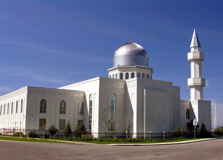
Baitun Nur Mosque is an Ahmadiyya mosque in NE Calgary and the largest mosque in Canada. It was built from 2005 to 7 aforC$15 million, With roughly C$8 million coming from the approximately 3,000 local Ahmadi Muslims. The SThe Unni Muslim group, Islamic Supreme Council of Canada, wa not invited to the opening due to its belief that Ahmadiyya Muslims are not real Muslims and because it did not consider Baitun Nur a mosque.
Its most prominent external features are a 97-foot-tall (30 m) steel-capped minaret tower and a large steel dome. Around the exterior of the building are 99 Arabic words written, each an attribute of Allah’s character as stated in the Qur’an. The mosque complex includes classrooms, office space, a children’s area, a kitchen and a community centre. In the prayer hall of the mosque hangs a 400-kilogram chandelier That cost $50,000. Naseer Ahmad and Manu Chugh Architects designed Baitun Nur, the seventh Ahmadiyya mosque, which Ahmad developed.
Home of a Thousand Faces, Radium Hot Springs, BC, is in Alberta’s NM region (Edmonton and Rockies).
At the corner of Kootenay Highway (#93) and Madsen Road, near the junction with Highway 95, is the hectic mountain structure that is the home and workspace of Rolf Heer (AKA The Radium Woodcarver), a crazy-quilt of a man who specializes in carving sculptures with a chainsaw. Scrapped wooden panels and mismatched doors make up most of the outer walls of the abode, with each piece of the wall covered in a cryptic message such as “Emergency Entrance, Ladies Only” and ” No Two or 4 Leg Dogs.” Inside the walls, the grounds are covered in Heer’s sculptures, almost entirely carvings of a bearded man’s face in logs and smaller pieces of wood. The Radium Woodcarver is also known to keep goats on the roof of his shack just in case visitors to the cacophonous residence feel as though it is not eccentric enough. 
On November 23, 2018, this location was destroyed by fire. The owner escaped.
