
QUEBEC EAST (Quebec City, Montmagny, Sept Îles)
I entered Quebec from New Brunswick at the start of the Gaspe Peninsula. There was no border control, and I drove in.
The architecture of the houses is very uninspiring—plain one-story homes with vinyl siding, little colour, few flowers, and no flower boxes.
GASPE PENINSULA
This is a peninsula along the south shore of the Saint Lawrence River to the east of the Matapedia Valley in Quebec. It is separated from New Brunswick on its southern side by the Baie des Chaleurs (Chaleur Bay) and the Restigouche River. The name Gaspé comes from the Mi’kmaq word gespe’g, meaning “end”, referring to the end of the land.
The Gaspé Peninsula is slightly larger than Belgium, at 31,075 square kilometres (11,998 sq mi). The population is 140,599 as of the 2011 census. It is also noted as the only region outside the Channel Islands to contain native speakers of Jersey Norman.
Sea cliffs dominate the peninsula’s northern shore along the St. Lawrence River.
Cap Gaspé, jutting into the Gulf of St. Lawrence, is the peninsula’s easternmost point. Percé Rock (or Rocher Percé), an island pierced by a natural arch, is located just offshore of the peninsula’s eastern end. The peninsula’s interior is a rugged northward continuation of the Appalachian Mountains called the Chic-Chocs, with Mont Jacques-Cartier at 1,268 metres (4,160 ft) the peninsula’s highest peak.
Mount Albert (Mont Albert) at 1,151 m (3,776 ft)[6] is another high mountain in the Chic-Chocs. Its summit, an alpine area above the tree line, is a nearly flat plateau about 13 km (8 mi) across, composed of serpentine bedrock and supporting a quite unusual flora. The ascent of Mount Albert from near sea level is challenging, but popular with hikers, offering a view of the St. Lawrence and the Côte-Nord, the river’s north shore, part of the ancient bedrock of the Canadian Shield.
The interior portions of the peninsula are dominated by the Chic-Choc Mountains, which are part of the Notre Dame Mountains, an extension of the Appalachian Mountains.
The town of Murdochville, at about 660 metres (2,170 ft) above sea level, has had a varied history and is now home to several wind turbines. It is reached by Route 198, which extends inland from the peninsula’s northern shore, soon climbing into the mountains and entering vast forests, crossing several small rivers before reaching the town. From Murdochville, Route 198 follows the York River to the city of Gaspé on the peninsula’s eastern tip.
The peninsula’s economy has historically been focused on fishing, agriculture, and forestry. However, primary resource-based industries are suffering due to overfishing, overexploitation, and fewer farmers in business, forcing the region to move towards tourism and the services industry.
The peninsula is one of Quebec’s most popular tourism regions. The Gaspé National Park (Parc national de la Gaspésie) is located in the Chic-Chocs, and Forillon National Park is at the peninsula’s northeastern tip. A section of the International Appalachian Trail travels through the peninsula’s mountains. Bonaventure National Park is also located here. As of September 2018, the area also hosts Canada’s third UNESCO Global Geopark—Géoparc de Percé.
Miguasha National Park. Miguasha National Park is the world’s most excellent palaeontological record of fossils from the Devonian Period, known as the ‘Age of Fishes’. Five of the six main fossil fish groups from this period (370 million years ago) can be found here. A significant quantity of some of the best-preserved fossil specimens of lobe-finned fish, ancestors to the tetrapods (believed to be the first four-legged air-breathing terrestrial vertebrates), were found here.
Miguasha was designated a World Heritage Site in 1999 in recognition of its wealth of fossils, which display a crucial time during the evolution of life on Earth. The museum’s collection includes over 9,000 specimens of fossil fish and plants.
The coastal cliffs are part of the Upper Devonian strata of grey sedimentary rock. They are composed of alternating layers of sandstone and shale, which are 350–375 million years old. The area today supports mainly birch, aspen, and fir forests. Some fish, fauna, and spore fossils found at Miguasha are rare and ancient. For example, Spermasposita is considered one of the oldest flowering plants. genera on Earth.
Percé is a small city near the tip of the Gaspé Peninsula. Within the city’s territory is a village community called Percé. Percé, a member of the association of Most Beautiful Villages of Quebec, is mainly a tourist location, particularly well known for the attractions of Percé Rock and Bonaventure Island.
The area was within the traditional homelands of the Mi’kmaq people, who called the place Sigsôg (“steep rocks” or “crags”) and Pelseg (“fishing place”). 1603 Samuel de Champlain visited the area and named the famous rock Isle Percée (“Pierced Island”). During the 17th century, the place was used primarily as a stopover for ships travelling to Quebec.
Used as a seasonal fishing centre during the New France era, permanent settlement began in the early 19th century with the arrival of Irish, French Canadian, and Jersey natives. Percé became the most important fishing location on the Gaspé Peninsula after Charles Robin, a native of Jersey, began his fishing establishment. Old buildings of the Charles Robin Company can still be seen there.sd
Percé Rock is a natural rock formation located close to the shore facing the town. It is a natural tourist attraction for its size, colour, and unusual door-like hole at one end of the rock. It can be seen from any of the belvederes in the area, including Mount Joli, Mount Sainte-Anne and Pic de l’Aurore. Tourists can walk up to the hole in the rock at low tide.
Bonaventure Island is 4.16 square km and faces the town of Percé. It is populated by one of the world’s most essential gannet colonies, and many other species of birds, such as puffins, cormorants, and murres, also use the island as a home and breeding ground. In 1951, a second arch collapsed, leaving the separated rock at the end.
Whale watching is also a popular attraction in the local area, and most notably, North Atlantic right whales, one of the rarest whales, have concentrated off Percé in 1995
Forillon National Park is located at the outer tip of the Gaspé Peninsula and covers 244 km2 (94 sq mi). Corillon was the first national park in Quebec, created in 1970. The park includes forests, the sea coast, salt marshes, dunes cliffs, and the Eastern End of the Appalachians.
This area was once used for its rich supply of wood. People living in L’Anse-au-Griffon were once involved in the lumber industry here. The park’s creation in 1970 was preceded by the removal of 225 families through expropriation.
This national park includes nesting colonies of sea birds, whales, and seals, as well as woodland mammalian species such as red fox, black bear, moose, lynx, mink, coyote, woodchuck, porcupine, snowshoe hare, beaver, and ermine. Raptors that inhabit this park are great horned owls, northern harriers, peregrine falcons, kestrels, bald eagles, rough-legged hawks, and ospreys.
The Grande-Grave National Heritage Site attests to the way of life of fishing families. Forillon encloses the site of Fort Péninsule, near the Penouille beach. This fortification was built during World War II to protect the Gaspé Bay, as was Fort Prével on the other side; had Germany conquered all of Europe, these forts would have sheltered British warships seeking refuge from German submarines. Visitors today can enter a tunnel to see the cannon in place since that time.
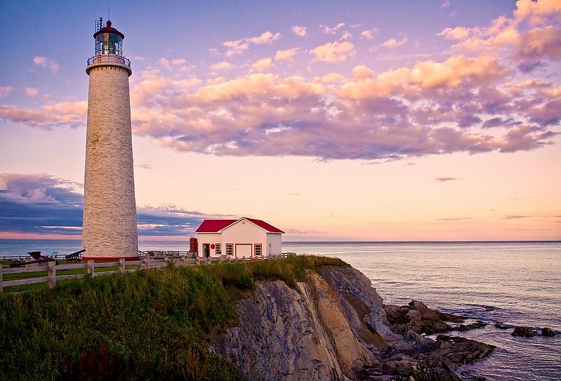
The Cap-des-Rosiers Lighthouse is the tallest in Canada at 34.1 metres (112 ft). It is situated on the south shore of the Saint Lawrence River at the top of a cliff. Built in 1858, this lighthouse is one of a series of tall, tapering towers erected on the Gulf of St. Lawrence and Lake Huron. The 112-foot structure is the tallest lighthouse in Canada; its stone tower with firebrick has walls over seven feet thick at the base, tapering to three feet at the top, and foundations extending to eight feet beneath the surface. A powerful light 136 feet above high water served as a significant coastal aid for shipping headed into the estuary of the St. Lawrence from the Gulf.
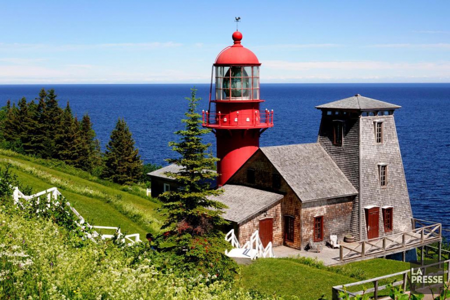
Phare de Pointe-à-la-Renommée. This lighthouse is 20 meters above sea level on a rocky point called “Pointe à la Renommée” south of Anticosti Island. It dominates the St. Lawrence River.
This formerly abandoned lighthouse was relocated in 1977 to Quebec City but was repatriated to its original site in Gaspésie in 1997.
Belvedere Jean Drapeau. I stopped at this lovely wayside park with gazebos and tables fronting a small lake.
Métis-Sur-Mer (pop 604). The name “Métis” is said to come from a Mi’kmaq word meaning “meeting place”; “sur-mer” refers to its location on the Saint Lawrence River.
From 1818, John MacNider, the Scottish Seigneur of Métis, started settling the area with Scottish immigrants. This small one-street town parallels the shore. The Town Center, dating from 1890, serves as the community hall.
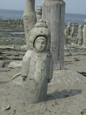
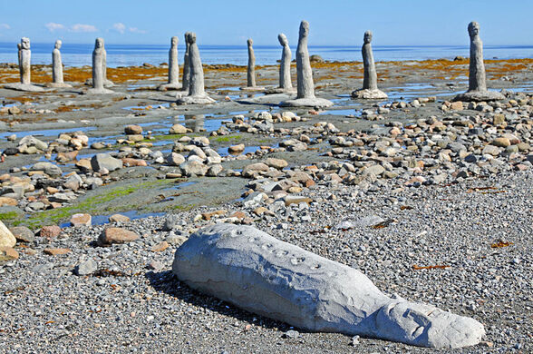
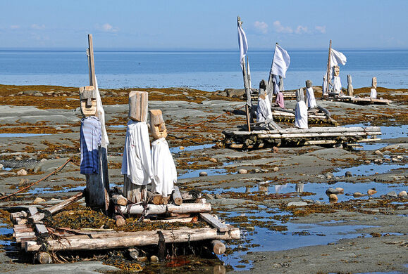
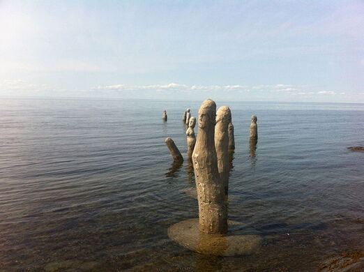
Sainte-Flavie. Sainte-Flavie is the westernmost point of Route 132’s loop around the Gaspé Peninsula; it is here where the highway intersects with itself. This one-street town sits on the water, with the 1878 grand stone Catholic church a highlight.
It is best known for The Grand Gathering, a changing group of over 100 crude wooden figures on the banks of and extending into the St Lawrence River.
Sainte-Luce-sur-Mer (pop 2,851). The parish was established in 1835. The name of Sainte-Luce was given in honour of Luce-Gertrude Drapeau (1794–1880), wife of the local notary, Thomas Casault, who established the seigneurie when the parish was canonized. The patron saint was Saint Lucy.
Because it had one of the nicest beaches in the area, it was nicknamed Sainte-Luce-sur-Mer. A long boardwalk runs the entire town, with the beach and water on one side, parking, restaurants, shops, and colourful houses on the other. There is a public piano at one end, a bathroom in the middle, and parking at the church at the other. The water is cold, so people go for the view, the water, and the sand.
Pohénégamook, Quebec / Estcourt Station, Maine. This is the northernmost point of the US outside of Alaska. Accessed from Canada, the “village” consists of one street of 11 houses, several for sale, and some boarded up. Cross the pedestrian “International Bridge” over the St Francis River to Canada and then back to Maine to drive around back to Canada.
Notre-Dame-du-Portage is one of the most beautiful villages in Quebec. The Roman Catholic Church was constructed in 1859. This village is distinctly different from any other in rural Quebec. Instead of drab architecture, it is full of high-end, lovely houses.
Saint-Pacôme. Another village sits on the St Lawrence.
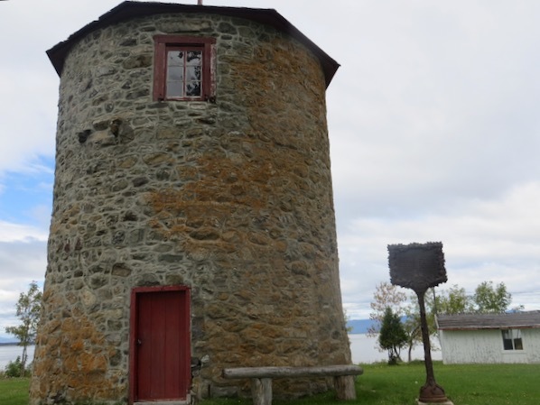
Moulin à vent Vincelotte, Cap-Saint-Ignace. It is one of the last 18 windmills in Quebec and the only one between Bécancour and Gaspé. Date of construction: 1690, made of field stone masonry with a diameter of 6.5m and a height of 7.4m. It has two levels. The door was wide open, but there was nothing inside – so little that I doubted it had ever been a windmill.
CANADA – QUEBEC WEST (Montreal, Saint-Jérôme, Trois-Rivières, Sherbrooke)
St. Regis. The Canadian side of the Mohawk Nation at Akwesasne territory straddles the intersection of international (United States and Canada) borders and provincial (Ontario and Quebec) boundaries on both banks of the St. Lawrence River. Most of the land and population are in what is otherwise present-day Canada. A small portion of the population is also in the United States. Although divided by an international border, the residents consider themselves one community. They maintain separate police forces due to jurisdictional issues and national laws.
The community was founded in the mid-18th century by Mohawk families from south of Montreal along the St. Lawrence River. Today, Akwesasne has a total of 12,000 residents. With the border settlement between Canada and the United States in the early 19th century, a larger portion of the territory was defined as within the United States. The portion in New York state is known as the federally recognized St. Regis Mohawk Reservation. The portion in Ontario is referred to as Akwesasne Reserve No. 59, and the portion in Quebec as Akwesasne Reserve No. 15.
Neuville (pop 3,888) is a village on the north shore of the Saint Lawrence River, just west of Quebec City. It was founded in 1684 and remains picturesque. Neuville has an excellent marina for pleasure sailboats and yachts.
The area was granted a seigneurie in 1653, and after 1716, it was known as Neuville.
Cap-Santé (pop 3,000). The name of the town means “Cape Health”. Cap-Santé is on the northern bank of the Saint Lawrence River, 40 kilometres (25 mi) west of Quebec City. The first settlers arrived around 1679, and in 1714, the village became an official parish. The present-day church, a historically registered building, was built from 1754 to 1767 and is one of the last buildings to be constructed under the French regime. The church has a facade and two towers and a baroque interior.
The Place de l’Église square is crowned with old wells dating back to 1799. Vieux Chemin street was built along the same geographical line as Chemin-du-Roy, the first road linking Montreal and Quebec City in the 18th century. Wooden and stone homes dot the narrow, shaded street bordering the cape. The quay is on the Saint Lawrence River.
Champlain (pop 1,566). Samuel de Champlain, founder of New France, named this municipality in 1632. A seigniory was granted in 1644.
North Hatley (pop 750). Located at the north end of Lake Massawippi, it is part of the Eastern Townships region of Quebec, also known as Estrie or Cantons de l’Est in French. Locals usually have to drive to the nearby towns of Magog or Sherbrooke to find big-city amenities, although there are smaller stores and cafés in the city which are open year-round. It is also home to many artists and craftspeople, including Naisi LeBaron, known locally for her “art naïve” paintings of village life in North Hatley and environs and local graphic artist Mellanie Beauchamp. Several Canadian Modernist poets have lived in North Hatley, including F. R. Scott, Louis Dudek, Ralph Gustafson, Ronald Sutherland, and D. G. Jones.
Many of the first settlers around North Hatley were United Empire Loyalists, mostly farmers, who left New England in the years following the American Declaration of Independence in 1776. The village owes most of its grand houses and particular architecture to its first aristocrats, and mostly Americans from south of the Mason–Dixon line.
Presbytere de St-Gregoire. This imposing grey black stone front has two bell towers. The main church is made of rough stone.
Île Perrot, Victoriaville. This island sits in the middle of the river that flows through Victoriaville. I could find no access.
Stanstead. Located on the Canada–United States border across from Derby Line, Vermont, it was created in 1995 by merging the former villages of Stanstead Plain and Beebe (formerly Beebe Plain) and the Town of Rock Island. Not only is Stanstead home to the Haskell Free Library and Opera House—the only heritage building deliberately constructed straddling the border between both countries—it also features Canusa Street, one of several streets in the world where the country border corresponds to the middle line marker, effectively making across the street neighbours residents of two countries.
Started in 1796, the town grew in the 19th century due to the influx of United Empire Loyalists and the development of the granite industry. The railroad reached Stanstead in 1871. Today, its tracks have been transformed into bike trails owned by the regional government.
It is also the home of the Dairy Association Company, the manufacturer of Bag Balm.
Access to homes on Canusa Street is made through the Canada–US border. U.S. citizens residing there must report to their customs if travelling south and to the Canadian customs if travelling elsewhere in Canada.
The Tomifobia River runs through Stanstead, sometimes dividing the Canada–US border along portions of Canada’s Canusa Street. Houses on the southern end of the street lie entirely within Vermont. At the same time, their driveways are directed northward and connect to the street in Quebec, as the northern portions of their properties are within Canada. These residents’ backyard neighbours are American, while families living across the street are Canadian, though no noticeable boundary exists between the two (the street itself is entirely within Canada). In other places, the international border runs through individual homes, so meals prepared in one country are eaten in another. Once operated by the Butterfield division of Litton Industries, an entire tool-and-die factory is divided into two by the border.
Rock Island is known for the Haskell Free Library and Opera House, deliberately constructed on the Canada–US border and opened in 1904. The original owners were a couple of people of dual nationality; Mr. Carlos F. Haskell was an American businessman from Derby Line who owned several sawmills, while Mrs. Haskell was born in Canada. The intent was for people on both sides of the border to use the facility, now a designated historic site. Visitors today may still enter the facility from the Canadian or American sides, though those who use it as a border crossing must report to their respective customs office.
A neoclassical building straddles the international border in Rock Island (now part of Stanstead), Quebec and Derby Line, Vermont.
The library collection and the opera stage are in Stanstead, but the main entrance and most opera seats are in Derby Line. Because of this, Haskell is sometimes called “the only library in the U.S.A. with no books” and “the only opera house in the U.S.A. with no stage”. There is no entrance from Canada; however, there is an emergency exit on the Canadian side of the building. All patrons and visitors must use the U.S. entrance to access the building. Patrons from Canada are permitted to enter the United States without needing to report to customs using a prescribed route through the sidewalk of Church Street, provided that they return to Canada immediately upon leaving the building using the same route.
A thick black line runs beneath the opera house seats and diagonally across the center of the library’s reading room to mark the Canada–United States border. The stage and half of the seats are in Canada; the rest of the opera hall is in the US. The building has different postal codes (93 Caswell Avenue, 05830 and 1, rue Church (Church Street), J0B 3E2) and different telephone area codes (+1-802-873-3022 and +1-819-876-2471) in its two respective countries.
The library has a collection of more than 20,000 books in French and English, and is open to the public 38 hours a week.
I parked near the car crossing post, crossed the footbridge and turned right, walking directly to the library. A row of flower pots marks the border. A guy in a truck flipped his siren when I stepped between the pots. The library is closed because of COVID-19.

Province Island (Quebec/Vermont) is an island mostly in the Canadian province of Québec, but 9% in the U.S. state of Vermont. It is situated in Lake Memphremagog. The island’s area is 0.31 km². The southern point is part of the United States (Town of Derby, Orleans County in the state of Vermont), while the greater part belongs to the municipality of Ogden, Quebec.
At the end of the 18th century, a pioneer named Martin Adams and his wife built a house on the island, where they grew flax and vegetables. Today, the island is owned privately; a pheasant hunt is organized annually. The Canada–United States border is marked by a five-meter strip cut through the forest.
Lake Memphremagog is a freshwater glacial lake between Newport, Vermont, United States and Magog, Quebec. The lake spans both Quebec and Vermont, but is mainly in Quebec. Most of the lake’s watershed is located in Vermont and is a source of accumulated phosphorus, sediments, and other pollutants. Cleanup efforts since the late 1980s have improved the water quality. The lake furnishes potable (drinking) water for 200,000 people.
The lake is 31 miles (50 km) long, with 73 percent of its surface area in Quebec, where it drains into the Magog River. However, three-quarters of its watershed, 489 square miles (1,270 km2), is in Vermont. The lake elevation is approximately 682 feet (208 m) above mean sea level.
Both ends of the lake are fairly shallow but take a dramatic drop in Canada, with a maximum recorded depth of 351 feet (107 m). It contains 21 islands. Province Island, the largest, is divided by the international border.[10] The lake is irregular in shape, and along its shores are several striking indentations, in some places low, and some other parts high and rocky. Along the lake’s western shore are several mountains, prominent among which are Owl’s Head, Elephantis, and the Hog’s Back.
In the middle of the winter, the ice on the lake can become 3 feet (0.9 m) thick. The Magog River, in Quebec, drains the lake towards the northeast. The hydroelectric producing Memphemagog Dam, on the Magog River, regulates the lake’s water level.
The lake is within the larger territory originally inhabited by the Abenaki tribe. The lake’s name, Memphremagog, is derived from the Algonkian language: Memrahabegek, which means “where there is a big expanse of water”.
Saint Benedict Abbey, Saint-Benoit-du-Lac, was founded in 1912 by the exiled (Fontenelle Abbey) of St. Wandrille, France, under Abbot Dom Joseph Pothier, a liturgist and scholar who reconstituted the Gregorian chant. Father Paul Bellot was the architect from 1939 to 41. The new priory later became independent within the Solesmes Congregation.
Today, it numbers over fifty monks living under the Rule of Saint Benedict. Cloistered from the world, they are enjoined to seek God in the celebration of the liturgy of the Church, in private prayer accompanied by meditation on the Bible, and in manual and intellectual work. They form a community under the direction of an Abbot.
Mont-Orford NP. The park is located immediately north of Magog in the Eastern Townships tourist region of the province. It encompasses several mountain peaks: Mont Orford, Mont Giroux (Pic aux Corbeaux), Mont Alfred Desrochers, Mont Chauve, and the Massif des Chênes.
The park is open year-round. Popular summer activities in the park include camping, hiking, swimming, cycling, canoeing, kayaking, pedalos, rowing, rock climbing, paddle surfing, and wildlife watching. The most popular winter sport in the park is alpine skiing, with cross-country skiing, snowshoeing, snow walking, and Ski-Vel (wheelchair skiing).
Saint-Jean-Sur-Richelieu (pop 95,000) is about 40 kilometres (25 mi) southeast of Montreal. It is situated on the west bank of the Richelieu River at the northernmost navigable point of Lake Champlain.
Historically, the city has been an important transportation hub. The first railway line in British North America connected it with La Prairie in 1836. It also hosts the annual International Balloon Festival of Saint-Jean-sur-Richelieu. This hot air balloon festival attracts thousands of tourists who come to see the hundreds of balloons in the sky each August.
The Chambly Canal extends 20 kilometres (12 mi) north along the river’s west bank and provides modern freight passage to Chambly and the St. Lawrence River. The canal has one lock near the downtown core of Saint-Jean-sur-Richelieu. In the winter, the city builds a skating rink on the canal near the lock.
The French built Fort Saint-Jean (Quebec) in the seventeenth century. It provided a vital communication link during the French and Indian Wars. During the American Revolutionary War, control of the town changed hands several times as British and American forces moved through the area.
St-Jean is a manufacturing centre for textiles, food, and wood products. It hosts an Area Support Unit (ASU) of the Canadian Forces, which is a primary recruit and officer training establishment.
Fort Chambly, Chambly. Built by the British between 1812 and 14, it housed 6,000 infantry, cavalry, and artillery troops. It was active during the War of 1812, the Rebellion of 1837-8, and the US Civil War. It is a square with square corner bastions.
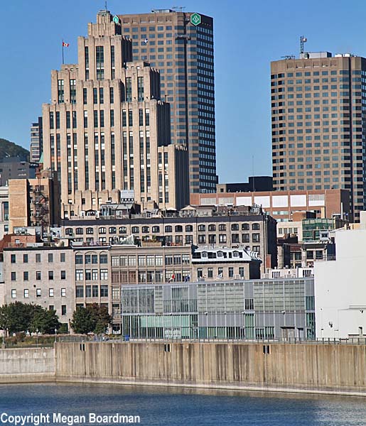
MONTREAL (pop 1,704,694, urban 1,942,247, metropolitan 4,098,247.
Montreal is the most populous city in Quebec, the second-most populous city in Canada and the second-largest primarily French-speaking city in the developed world, after Paris.. Initially founded in 1642 as Ville-Marie, or “City of Mary”, It is named after Mount Royal, The triple-peaked hill iis i the heart of the city. scet o the Island of Montreal, which got its name from the same origin as the city and a few much smaller peripheral islands, the largest of which is Île Bizard. The town is situated 196 km (122 mi) east of the national capital, Ottawa, and 258 km (160 mi) southeast of the provincial capital, Quebec City.
French is the city’s official language In 2016, 49.8% of the population spoke Irish as their primary home language, 22.8% spoke English, and 18.3% spoke other languages. In the metropolitan area, 5.8% of the population spoke French at home, compared to 15.3% who spoke English. Montreal is one of the most bilingual cities in Quebec and Canada, with over 59% of the population speaking English and French.
Historically, the commercial capital of Canada, Montreal, was surpassed in population and economic strength by Toronto in the 1970s. It remains an important centre of commerce, aerospace, transport, finance, pharmaceuticals, technology, design, education, art, culture, tourism, food, fashion, gaming, film, and world affairs. Montreal has the second-highest number of consulates in North America, serves as the location of the headquarters of the International Civil Aviation Organization, and was named a UNESCO City of Design in 2006. In 2017, Montreal was ranked the 12th most liveable city in the world by the Economist Intelligence Unit in its annual Global Liveability Ranking. It was the best city in the world to be a university student in the QS World University Rankings.
Montreal has hosted multiple international conferences and events, including the 1967 International and Universal Exposition and the 1976 Summer Olympics. It is the only Canadian city to have held the Summer Olympics. In 2018, Montreal was ranked as an Alpha− world city. As of 2016, the city has hosted the Canadian Grand Prix of Formula One, the Montreal International Jazz Festival, and the Just for Laughs festival.
Verdun is a borough of Montreal, Quebec, located in the southeastern part of the Island of Montreal on the St. Lawrence River. The settlement of Verdun was founded in 1671, making it one of Canada’s oldest cities. It also includes Nuns’ Island (Île des Sœurs). Verdun proper and Nuns’ Island are joined by the Pont de l’Île-des-Sœurs on Aut. 15, part of the Champlain Bridge complex that crosses Nuns’ Island and links it to Brossard on the south shore of the St. Lawrence.
The city was chiefly English-speaking (59% in 1931). Improved access to downtown Montreal meant a decline in local commerce. Starting in the 1990s, a program of subsidies and revitalization reinvigorated the rue Wellington commercial corridor.
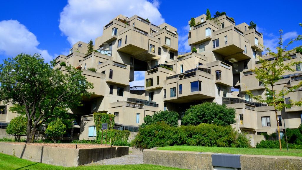
Habitat 67, or simply Habitat, is a model community and housing complex in Montreal, designed by Israeli-Canadian architect Moshe Safdie. It was initially conceived as his master’s thesis in architecture at McGill University and then built as a pavilion for Expo 67, the World’s Fair held from April to October 1967. It is located at 2600 Avenue Pierre-Dupuy on the Marc-Drouin Quay next to the Saint Lawrence River. Habitat 67 is widely considered an architectural landmark and one of the most recognizable buildings in both Montreal and Canada.
The federal government financed the development, but its tenants now own it. They formed a limited partnership that purchased the building from the Canada Mortgage and Housing Corporation in 1985. Safdie still owns a penthouse apartment in the building.
Habitat 67 comprises 354 identical, prefabricated concrete forms arranged in various combinations, reaching up to 12 stories in height. These units create 146 residences of varying sizes and configurations, each formed from one to eight linked concrete units. Each unit is connected to at least one private terrace, ranging from approximately 20 to 90 square metres (225 to 1,000 sq ft) in size.
The development was designed to integrate the benefits of suburban homes—gardens, fresh air, privacy, and multilevelled environments—with the economics and density of a modern urban apartment building.
Housing was also one of Expo 67’s main themes. Habitat 67 then became a thematic pavilion visited by thousands of visitors from around the world. During the expo, it also served as the temporary residence of the many dignitaries visiting Montreal.
Royal Bank Tower is a 22-storey, 121 m (397 ft) neo-classical tower skyscraper at 360 Saint-Jacques Street. When completed in 1928, it was the tallest building in the entire British Empire, the tallest structure in all of Canada and the first building in the city taller than Montréal’s Notre-Dame Basilica, built nearly a century before.
In 1907, the Royal Bank of Canada moved its head office from Halifax to Montreal. In 1962, it moved its main office to another famous Montreal building, Place Ville-Marie. However, it kept a branch in the impressive main hall of the old building in Old Montreal.
/cdn.vox-cdn.com/uploads/chorus_image/image/48670793/rbctower.0.0.jpg)
Aldred Building is an Art Deco building on the historic Place d’Armes square in Old Montreal, completed in 1931. It is 96 metres (316 ft) high, or 23 storeys. The building’s setbacks at the 8th, 13th, and 16th floors allow more light on the square and create a cathedral-like massing, reflecting the adjacent Notre-Dame Basilica. The building uses limestone, which is common to other buildings.
The building resembles New York’s Empire State Building, completed the same year, and was built for Aldred and Company Limited, a New York City-based international finance company.
Notre-Dame Basilica of Montreal is in the historic district of Old Montreal, facing the Place d’Armes square. Its interior is amongst the most dramatic in the world and is regarded as a masterpiece of Gothic Revival architecture. The vaults are deep blue and decorated with golden stars, and the rest of the sanctuary is decorated in blues, azures, reds, purples, silver, and gold. It is filled with hundreds of intricate wooden carvings and several religious statues. Unusual for a church, the stained glass windows along the sanctuary’s walls do not depict biblical scenes, but rather scenes from the religious history of Montreal. It also has a Casavant Frères pipe organ, dated 1891, consisting of our keyboards, 92 stops using electropneumatic action, an adjustable combination system, 7000 individual pipes and a pedal board.
Approximately 11 million people visit Notre-Dame Basilica every year, making it one of the most visited monuments in North America.
The Chapel of Notre Dame de Bon Secours is a church in the district of Old Montreal. One of the oldest churches in Montreal, it was built in 1771 over the ruins of an earlier chapel. In the 19th century, the chapel came to be a pilgrimage site for the sailors who arrived in the Old Port of Montreal, and the chapel is often called the Sailors’ Church. The chapel now also houses the Marguerite Bourgeoys Museum, which is dedicated to the life of St. Marguerite Bourgeoys and the early history of Montreal and the chapel site. The church’s prominent spire can also be climbed, offering views of the Old Port and the Saint Lawrence River
Sir George-Étienne Cartier National Historic Site is a historic house museum in Old Montreal commemorating the life and accomplishments of Sir George-Étienne Cartier. This reconstitution of the adjoining homes of the Cartier family features the architectural heritage left by the upper middle class of 19th-century Montreal, along with interpretive activities and theatrical performances.
Sir George-Etienne Cartier (1814 – 1873) was a Canadian statesman and Father of Confederation. In the years leading up to Confederation, Cartier was a dominant figure in the politics of Canada East as leader of the Parti bleu. In 1838, he returned to Montreal after a year in exile for his role in the Lower Canada Rebellion. He officially entered politics in 1848. During his long career he promoted the establishment of the Civil Code as the formal law of Canada East, instead of the use o fcommon law as was present in Canada West. He also promoted the introduction of primary education in the province. Cartier had several reasons for supporting Confederation, notably his fear of American expansion. He died in London, England, on May 20, 1873.
Château Ramezay is a museum and historic building on Notre-Dame Street in Old Montreal, opposite Montreal City Hall. Built in 1705 as the residence of the then-governor of Montreal, Claude de Ramezay, the Château was the first building proclaimed as a historical monument in Quebec and is the province’s oldest private history museum. Over the years, the Château changed owners and functions several times, with Ramezay’s descendants selling the manor to the fur-trading Compagnie des Indes.
From 1775, it became the Canadian headquarters for the Continental Army when it seized Montreal. Benjamin Franklin stayed there overnight in 1776. After the conquest until 1849, the house was used by the British governors and was known as the Government House. In 1878, the building opened its doors to host Université de Montréal’s first Faculty of Medicine. A museum and portrait gallery since 1894, today, the museum’s collection is composed mainly of gifts from private Montrealers. It is estimated at 30,000 objects, including manuscripts, printed works, numismatic items, ethnological items, works of art, paintings, prints and furniture.
Fontaine Park is a 34 ha (84 acres) urban park in the borough of Le Plateau-Mont-Royal in Montreal. Named in honour of Louis-Hippolyte Lafontaine, the park’s features include two linked ponds with a fountain and waterfalls, the Théâtre de Verdure open-air venue, the Calixa-Lavallée cultural centre, a monument to Adam Dollard des Ormeaux, playing fields and tennis courts. Its outdoor swimming pools are a popular attraction during Montreal’s hot summers, with outdoor ice skating in winter. Bike paths run along the park’s western and northern edges.
Marché Jean-Talon is a farmers’ market in Montreal’s Little Italy district. It is the largest open-air market in Montreal and North America.
The market was opened to the public in 1933. Its single building (the chalet) quickly became the focal point for developing the area around it—a bus terminal, a municipal library, and a social services centre.
The market is open year-round, even during Montreal’s severe winters, although walls surround the central section and outdoor areas remain vacant. During the peak summer period, between May and October, its open-air arcades are occupied by about 300 vendors, mostly farmers from the countryside around Montreal.
Other food businesses, including meat, fish, and cheese stores, bulk food emporia, spices and imported goods dealers, bakeries, restaurants, and a branch of the SAQ surround the open-air market.
Montreal Central Station is Montreal’s major inter-city rail station and commuter rail hub. Nearly 11 million rail passengers use the station every year making it the second-busiest train station in Canada. The main concourse occupies almost the entire block, where pedestrian access is assured by numerous links through neighbouring buildings. The station’s interior and exterior are adorned with art deco bas-relief friezes. Canadian National Railway (CN) has owned the station since its inception in 1943.
Central Station is at the centre of the Quebec City–Windsor Corridor, the busiest inter-city rail service area in the nation (marketed as the Corridor), which extends from Windsor and Sarnia in the west, through Toronto, Ottawa, and Montreal, to Quebec City in the east. Inter-city trains at Central Station are operated by Via Rail and Amtrak, with commuter rail services (RTM) and the Montreal Metro subway system.
Château Dufresne is a historic building that currently functions as a historic house museum. Built from 1915 to 1918, the mansion was designed in the Beaux-Arts style with forty rooms covering about 20,000 square feet.
The interior was decorated with a series of murals and ceiling paintings by Guido Nincheri in the 1920s and 1930s. The mansion was built as the residence of Marius Dufresne and Oscar Dufresne, two wealthy French Canadian entrepreneurs who played a significant role in the history of Maisonneuve (now part of Montreal). The Château Dufresne was initially divided into two separate households, one for each brother. In 1948, the Dufresne family sold the property to the Congregation of the Holy Cross, which used it as a pavilion annex of the Holy Cross College. In 1999, the building housed the Château Dufresne Museum, which was renamed the Dufresne-Nincheri Museum in 2014.
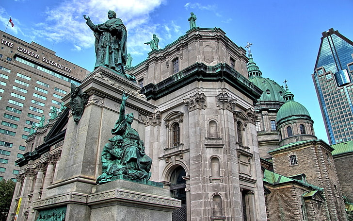
Marie Reine du Monde Cathedral (Marie, Queen of the World and St. James the Great Cathedral) is a minor basilica in Montreal and the seat of the Roman Catholic archdiocese of Montreal. It is the third largest church in Quebec after Saint Joseph’s Oratory (also in Montreal) and the Basilica of Sainte-Anne-de-Beaupré east of Quebec City. The building is 101 m (333 ft) in length, 46 m (150 ft) in width, and a maximum height of 77 m (252 ft) at the cupola, the diameter of which is 23 m (75 ft).
The sacrament of baptism is celebrated in the small chapel. The marble baptismal font is surmounted by an impressive stucco crucifix sculpted by Philippe Hébert. The crucifix is one of Quebec’s most important pieces of religious sculpture.
Construction began between 1875 and 1894, and it was called Saint James Cathedral. Pope Pius XII rededicated it in 1955 to Mary, Queen of the World, at the request of Cardinal Paul-Émile Léger.
L’Auberge Saint-Gabriel Inn. Located in Old Montreal, this was the first establishment to have an alcohol license issued in 1754 under British rule. Established in 1754, this historic landmark remains a tourist destination, updated with a refined French restaurant. To add on, it is also allegedly haunted by the ghost of a 19th-century girl who died in a building fire.
The interior decor features thick stone walls surrounding round and square tables on wooden plank floors below wrought-iron chandeliers. It is also home to several banquet rooms for private functions, a club in the basement, and valet parking. Auberge is home to elegant and expensive food. Lesley states, “Price range: Starters, $6-$23; main courses, $23-$47; desserts, $6-$9. Three-course table d’hôte: $32-$44, Lunch-time table d’hôte: $18-$22.
Church of La Visitation-de-la-Bienheureuse-Vierge-Marie is a church in Recollet Falls in Montreal. The oldest church on the island of Montreal, it was built between 1749 and 175
Nelson’s Column is a monument erected in 1809 in Place Jacques-Cartier dedicated to the memory of Admiral Horatio Nelson, following his death at the Battle of Trafalgar. After the destruction of Nelson’s Pillar in Dublin (1808–1966), Montreal’s pillar now stands as the second-oldest “Nelson’s Column” in the world, after the Nelson Monument in Glasgow. It is also the city’s oldest monument and is the oldest war monument in Canada.
The column was made of grey compact limestone, while the statue and ornaments were made using the firm’s invention, Coade stone. The final cost of the column amounted to just under £1,300. The Horatio Nelson statue that originally stood atop Nelson’s column in Place Jacques Cartier was relocated to the Montreal History Museum in 1997 for preservation. A copy now stands atop the column in its place.
As it is a monument to a British officer who fought against France in a predominantly French-speaking city, it has garnered its share of controversy. In 1890, a Quebec nationalist faction plotted to blow up the column. In 1930, Francophone Montrealers responded to Nelson’s presence by erecting a statue in a nearby city square (now known as Vauquelin Square), commemorating Jean Vauquelin, a French naval officer who fought during the Seven Years’ War. Still, many French Canadians continued to object to Nelson’s presence. In 1997, the City of Montreal proposed moving the monument to a distant Anglophone district, but public opposition kept Montreal’s oldest monument in its original place.
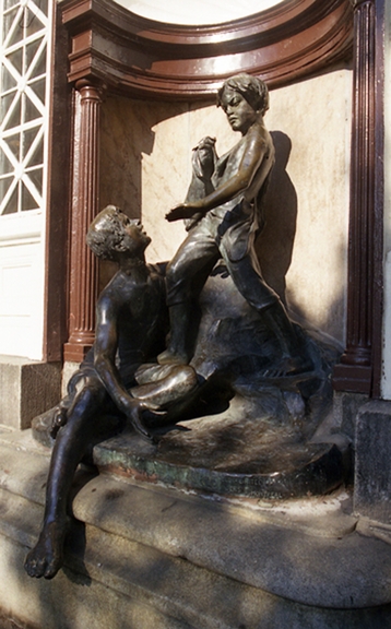
Les petits baigneurs is a bronze sculpture portraying a contemporary bathing scene. A sitting person splashes a standing person, who doesn’t enjoy the game. The asymmetrical composition, part of which projects beyond the niche formed of a shell and two fluted columns, creates a sense of dynamism. The fountain reflects Québec folklore as a city bath, moving it to a rural context.
It was commissioned in 1915 by the Cité de Maisonneuve to adorn the façade of the Maisonneuve baths and gymnasium (today Morgan Baths).
Complexe Desjardins is a mixed-use office, hotel, and shopping mall complex on Saint Catherine Street. The project was designed to develop the eastern end of downtown Montreal. Its architectural design consists of several towers housing offices of the Desjardins Group, Quebec Government offices and other companies, and a hotel, linked by an atrium shopping centre anchored by IGA. This design produces the effect of an indoor square.
The underground city connects the Complexe Desjardins to Place des Arts and the Place-des-Arts Metro station to the north, and the Complexe Guy-Favreau, the Palais des congrès de Montréal, and Place-d’Armes Metro station to the south.
The hotel in the complex opened as the Hotel Meridien Montreal in 1976. It was later renamed Wyndham Montreal, Hyatt Regency Montreal in 2003, and DoubleTree by Hilton Montreal in December 2018.
Pointe-Claire Windmill is the oldest windmill on the island of Montreal and one of 18 remaining windmills in Quebec. Like most mills in New France, it was built in French, with a cylindrical stone tower with a movable roof that a tail pole could turn to face the sails into the wind. The mill had two doors to provide an exit, regardless of which way the sails faced. The walls are four French feet (1 m32) thick at the base. The interior is 12 French feet in diameter by 24 feet high. The mill originally contained elevated platforms beneath gun slits for defence. The surrounding shoreline was fenced with pointed wooden stakes. However, the site was never attacked.
1709-10: construction. 1824: major renovation. 1837: 1885 (approximately): new sails. 1954: restoration, conical roof. 1967: new sails

