
Suriname (Surinam, Republic of Suriname is on the northeastern Atlantic coast and bordered by French Guiana to the east, Guyana to the west, and Brazil to the south.
Capital: Paramaribo
Area: 165,000 square kilometers (the smallest sovereign state in South America
Population: 575,990 most live on the country’s north coast in or near Paramaribo.
Language: Dutch 60% (Suriname is the only sovereign nation outside of Europe where Dutch is the official and prevailing language. Sranan Tongo, an English-based creole language, is a widely used lingua franca.
Religion. Christianity 52.3% (26.7% Protestant and 21.6% Catholics), Hinduism 18.8%, Islam 14.3%, Other 2.8%.
Money: Surinamese Dollar (SRD). Conversion xe.com Jan 2022: 1E = 23.6 SRD; 1US$ = 20.75 SRD; 1CAD$ = 16.4 SRD
Country Code: +597
Electrical plug: North American 2-prong.
Drive: on the left, a hold-over from British days.
Suriname – North (Paramaribo, Brokopondo, Albina) Jan 9-12, 2022
GET IN
Requirements:
1. Covid double vaccination
2. Antigen test only (not a PCR) 24 hours ahead. Eureka Labs, Georgetown 4000 GD, results in 1.5 hours by email
3. Yellow Fever Certificate
4. Surinam E-visa
Guyana (Georgetown) to Suriname (Paramaribo) Overland
Few foreigners do this trip overland as there is no provision in the Surinam e-visa for an overland journey – only a plane ticket is accepted on the visa form. I used fakeflighttickets.com to get a very realistic fake ticket for the visa ($10). Itinerary.com and the many PDF form websites produce a very inferior ticket and cost more. Itinerary actually refunded the fee after I complained that their product was inferior.
I used Dugla & Terry Bus & Taxi Service in Georgetown – WhatsApp +592 6220203, +597 896-9658. The owner and commonly the driver, Joshua, is a very dependable guy. He is easy to contact and returns calls promptly. He has been driving this route for 15 years, usually daily. He is also a very competent driver and drives quite fast. He is a smart guy, generous and follows virtually every comment with “you understand?”
Cost 8,000 GD (about US$40) including the ride on the other side of the Guyana/Suriname border to Paramaribo (he gives you a card to give to the Surinam driver, usually Terry, his partner) but this does not include the ferry.
He arrived at my hotel at 4:00 am promptly, calling me on WhatsApp a minute before he arrived. The vehicle was a Toyota car instead of his van as there were only 4 passengers on the morning we did the trip. I got the front seat, a very comfortable seat as three sitting in the back gives much less room. The drive to the border is about 3.5 hours.
We stopped for coffee and a hotdog just before the Berbice Bridge. Joshua simply walked into the kitchen, made coffee, got three hotdogs and didn’t charge me. This pontoon bridge crosses the wide Berbice River just before it enters the Atlantic.
No. 63 Beach. Fairly close to the Suriname border, Joshua kindly made a detour on the road with many speed bumps to see the beach.
Much of the two-lane road has houses on both sides because of its proximity to the ocean and beaches. Not much seemed to slow Joshua down and we cruised through maintaining 90km/hour fairly consistently. We only hit one dog, easily the most common thing on the road. We passed several mosques, Hindu temples and churches as we approached Suriname.
We arrived at the ferry terminal at 07:30 am and then had to deal with Guyana customs. Fill out two forms requiring addresses and phone numbers of accommodation in Georgetown and Paramaribo. They check the Covid antigen test, vaccine cards, yellow fever card, and the Suriname E-tourist card.
I exchanged some Euros to get the money for the ferry and got Suriname money as change. Exchange a little more as you stop for lunch. The forms are examined twice more, baggage goes through a scanner, everything is checked once more and you finally get the Guyana exit stamp on your passport. OMG.
I then had 1½ hour to wait for the ferry. With all the bureaucracy, it is good to have time in case all the ducks are not lined up. There is a small snack bar in the waiting area that sells ice cream and drinks and a Duty-Free.
Ferry 3,150 GD in cash. Paid before immigration in Guyana. There are gazebos and long benches in the shade to wait. The ferry arrived at 10, cars boarded at 10:15 and we boarded at 10:20. It is a long crossing of the wide Courantyne River to Suriname taking 30 minutes. The Suriname immigration was a breeze and took 1 minute (maybe because the Guyana side does such an over-the-top job).
We had a full van full with 6 passengers and barely room for all the luggage. It was another 3-hour drive to Paramaribo on a narrow 2-lane highway (some potholes and speed bumps in towns but generally quite a fast trip). Pass through fields of rice and cows. They drop you off at your hotel.
By plane. The international airport is Johan Adolf Pengel International Airport, 60 km from Paramaribo and a $20 taxi ride. It is considerably cheaper to do the drive.
Surinam Airways flies most days between Georgetown and Paramaribo.
Observations about Paramaribo
1. People. The people are almost entirely black or brown. I saw no other Caucasians when I was in Paramaribo for 3 days. Chinese have a presence outweighing their numbers as they seem to run most small supermarkets.
2. Hair. I always find black people’s hair fascinating. Here the women are very practical – there are few hair extensions and most have natural hairstyles keeping their hair relatively short, sometimes braided but more often gathered and kept on top, sometimes as several small “poms”.
3. Shacks. The city has many small shacks interspersed with “normal” houses. They are tiny, ancient, dilapidated, unpainted clapboard with rusted, corrugated roofs. It seems hard to believe that anyone lives in them, but most seem to have residents.
4. Tourism.There are few tourists in the times of Covid. There is not much to see here as a tourist. Most places are closed. The one place worth going to, the Central Suriname Nature Reserve, was impossible to go to as with the few tourists, there was no interest.
5. Covid. Hand sanitizer, temperature checks, and masks are mandatory at every business.
PARAMARIBO (pop 241,000 people 2012, almost half of Suriname’s population)
The capital and largest city of Suriname is located on the banks of the Suriname River, approximately 15 kilometres (9.3 mi) inland from the Atlantic Ocean. The historic inner city of Paramaribo has been a UNESCO World Heritage Site since 2002.
The city is named for the Paramaribo tribe living at the mouth of the Suriname River; the name is from Tupi–Guarani para “large river” + maribo “inhabitants”.
History. This was the location of the first Dutch settlement, a trading post established in 1613. English and French traders also tried to establish settlements in Suriname, including a French post established in 1644 near present-day Paramaribo.
All earlier settlements were abandoned sometime before the arrival of English settlers in 1650 to found Surinam. They established a town on the site of Paramaribo. The town was protected by a fort, called Fort Willoughby.
In 1667, during the Second Anglo-Dutch War, Paramaribo was conquered by a squadron of Dutch ships. The fort protecting Paramaribo was renamed Fort Zeelandia in honor of the Dutch province that had financed Crijnssen’s fleet.
The population of Paramaribo has always been very diverse. Among the first British settlers were many Jews and one of the oldest synagogues in the Americas is found in Paramaribo. The population of the town was greatly increased after 1873, when former enslaved people (who had been freed in 1863) were allowed to stop working for their former masters and leave the sugar plantations.
Paramaribo has remained the capital of Suriname, from its colonial days through the independence of Suriname in 1975 to the present day. The old town has suffered many devastating fires over the years, notably in January 1821 (which destroyed over 400 buildings) and September 1832 (which destroyed nearly 50 buildings). The slaves Kodjo, Mentor, and Present were found guilty of arson and burnt alive.
Climate. Paramaribo features a tropical rainforest climate and sees no tropical cyclones. The city has no true dry season; all 12 months of the year average more than 60 millimetres or 2.4 inches of rainfall. September through November is the driest and rainiest from April to July. Temperatures are relatively consistent with average high temperatures of 31 and average low temperatures of 22 and 87 inches of rainfall each year
Demography. The city is famed for its diverse ethnic makeup, including Creoles (African or mixed African-European descent) 27%, Indian (East Indian descent) 23%, Multiracials 18%, Maroons (descendants of escaped enslaved Africans) 16%, Javanese (Indonesian descent) 10%, Indigenous (descendants of the native population) 2%, Chinese (descendants of 19th-century contract workers) 1.5%, and smaller numbers of Europeans (primarily of Dutch and Portuguese descent), Lebanese and Jews. In the past decades a significant number of Brazilians, Guyanese and new Chinese immigrants have settled in Paramaribo.
Economy. Paramaribo is the business and financial centre of Suriname. Even though the capital city does not produce significant goods itself, almost all revenues from the country’s main export products gold, oil, bauxite, rice, and tropical wood are channeled through its institutions.
Tourism is an increasingly important sector, with most visitors coming from the Netherlands. Paramaribo is served by the Johan Adolf Pengel (PBM) and Zorg en Hoop (ORG) for local flights.
Get Around
Paramaribo doesn’t have share taxis that roam the big streets but a large fleet of identical-looking buses that seat about 24. They travel set routes. Buses to different areas congregate on their own streets in roughly the same four-block area of Paramaribo. Fares are 85 cents.
I stayed at Hofste apartments, Hofstede Crull’laan 30, Paramaribo.
Tel / App; +597 8588161. hpeimport@gmail.com. Leo Jacobs is the owner and is very pleasant. This was a great deal at US$10/night with nice small rooms (fan, AC, kettle, mosquito net, refrigerator, TV, good wifi). 5º50’56.17″N 55º15’45″W
I got some money from a nearby ATM and shopped at a Chinese mini-market. There are a few restaurants nearby. All three are in different directions from the hotel.
Day 2
I had a walkabout seeing all of Paramaribo.
Het Rumhuis. This small museum is located on the grounds of Suriname Alcoholic Beverages established in 1989 as an offshoot of Marienberg Rum. Housed in a white, brick building that is mainly a gift shop for rum, the small room has medals, certificates, photos, old bottles of rum and small sign boards explaining the distillation process. Free
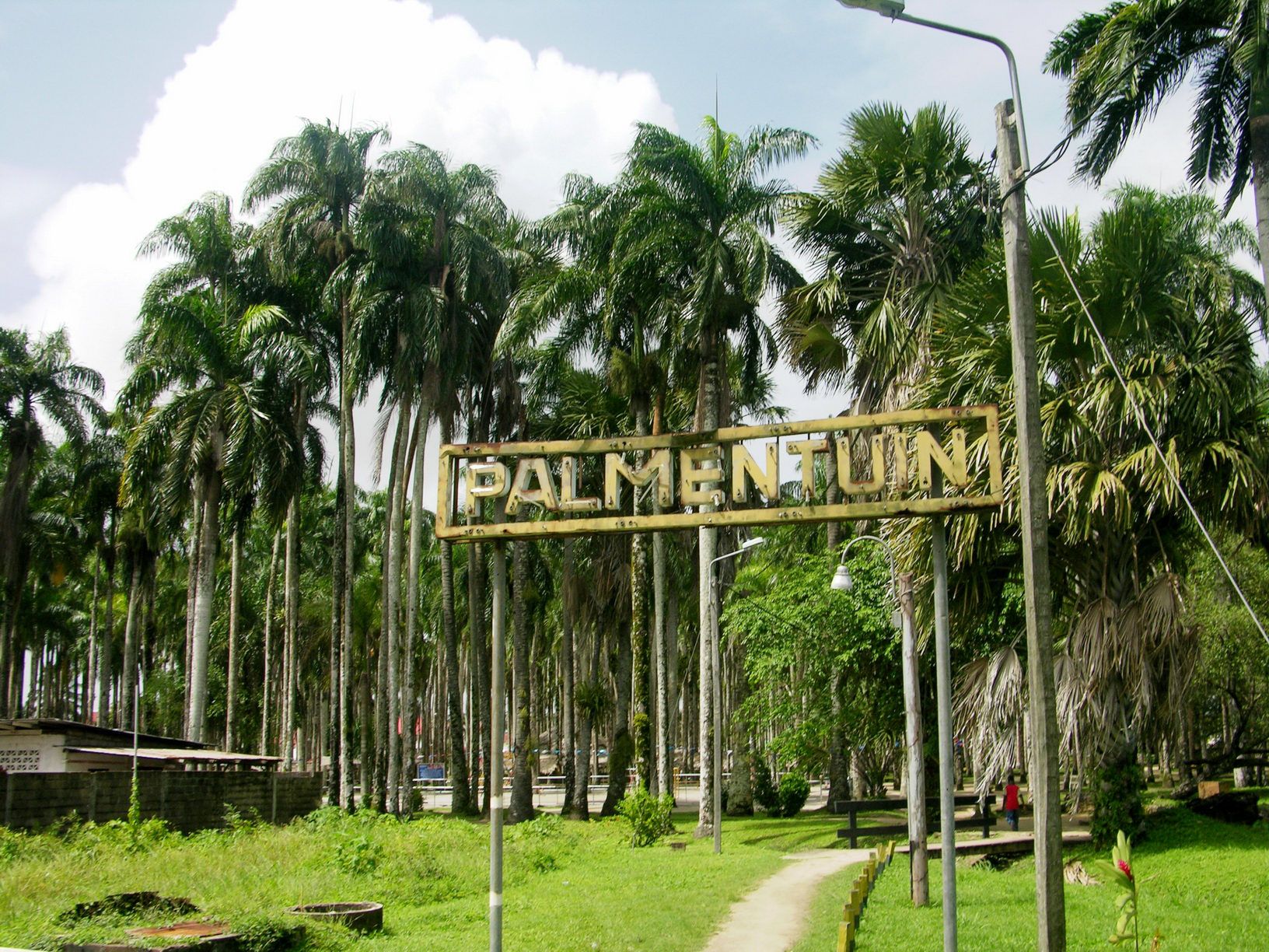
Palm Garden (Palmentuin). This is a lovely landscape park with grass and tall mature mature royal palm trees behind the presidential palace.
Baba & Mai Plein. This small statue of a man and woman commemorates Hindustani immigrants who arrived between 1873 and 1916 as indentured servants. There are 64 names listed.
Surinaams Museum. Housed in Fort Zeelandia, this museum occupies most of the buildings inside the fort using all 3 stories. There is a complete collection of artifacts and story boards, unfortunately almost completely in Dutch. There is ittle is of real interest because of that and there are no outstanding highlights. One of the only things in English was a biography of Gerret Schouten (1779-1830), the first famous coloured artist who constructed many small dioramas of Suriname scenes. A stone mask weighing 2 kg may be the highlight – it graces most of the books about Suriname history. It is not worth the price of admission. 125 SD
Fort Zeelandia. This small hexagonal brick fort has 5 bastions.

Historic Inner City of Paramaribo. The Dutch colonial town established in 17th and 18th centuries was declared a UNESCO World Heritage Site in 2002. The historic inner city is located along the left bank of the Suriname River. The original architecture of buildings and street plan has largely remained intact and preserved.
Occupying several city blocks bordered by the Palm Garden and Independence Square, the buildings are mostly white, two-story (+ and attic) with coloured trim, shutters and some balconies.

Independence Square. This medium-sized park is grass with trees on the side. The Presidential Palace is on one side.
Mahatma Gandhi statue. This small bronze statue of Gandhi sits on a round plinth surrounded by some marble walls and semi-circular steps. On the plaque is written “I HAVE NOTHING NEW TO TEACH THE WORLD. TRUTH AND NONVIOLENCE ARE AS OLD AS THE HILLS”.
Central Market. In a huge building, produce set on heavy flat tables is the main thing being sold. The selection was mediocre compared to similar markets elsewhere. Half the tables were empty. There were few places to eat.
Arya Dewaker Hindu Temple. The biggest mandirs (Hindu temples) of Suriname, it was officially opened on 11 February 2001 and is the main temple of the 16,661 Hindus who are said to belong this Hindu reform movement inspired by Swami Dayananda Sarasvati (1823-1883).
An Aryan temple, moreover, has no images. The upper floor is the space where the ceremonies are performed. The place for burning the fire is in the centre of the octagonal hall, whereas the benches are placed in circles surrounding the fireplace, which emphasizes that all people attending the fire ceremony are in principle equal. The roofs of the two smaller towers and the tower on the big dome of the temple all have four floors, a number referring to the four Vedas, the oldest scriptures of Hinduism. The building does not contain any image of divinity. Instead, the building is covered by many texts derived from the Vedas and other Hindu scriptures. The beautiful architecture makes the temple a tourist attraction. The swastika stands for salvation and the Om-syllable refers to the absolute God, whereas a recitation of Vedic verses is considered to be very powerful. It is a “wedding cake” with stacked platforms and a huge red onion dome, all white with orange symbols and swastikas. It is apparently open only from 9-10.

It was a big walk here and I got another view of Paramaribo and then a bigger walk back to the Historic District.
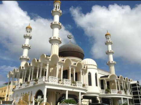
Mosque Keizerstraat (SIV Mosque). The Muslim community of Paramaribo was established in 1929. Its first mosque, a wooden rectangular building with minarets, was completed in 1932. In 1979 boxing legend Muhammad Ali visited the mosque. The current mosque was completed in 1984. It is a very attractive white building with four minarets, columns supporting a veranda, a large prayer hall on the second floor, and gold stars and crescents. Mosque Keizerstraat is adjacent to the synagogue.
Neveh Shalom Synagogue is the only synagogue of the Ashkenazi community in Suriname. The lot on Keizerstraat 82 was acquired in 1716 by Sephardi Jews. The original building was completed in 1723. Originally for both the Ashkenazim and the Sephardim community, the synagogue was sold to the Ashkenazim in 1735. The two communities have merged in the 1990s,[4] and hold services in alternating buildings and alternating rites.
The current synagogue on the Keizerstraat 82 lot, designed by architect J.F. Halfhide, was completed in 1842. The synagogue contains a small museum about the history of the Jews in Suriname. It is a two-story white rectangular building with many windows and 4 grand columns over the porch. Guided tours are available on Monday, Wednesday and Thursday from 10-2 by calling 472817/8118844/7190076 or emailing istgem@sr.net. There is a very solid heavy steel barred fence.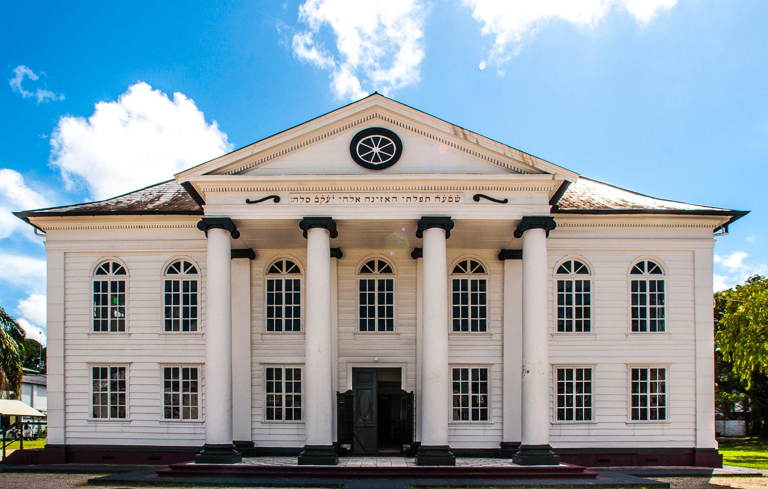 Het Koto Museum. Shows the history, culture, and traditions of Suriname through displays of traditional clothing worn by Surinamese women, with some garments dating back to the 1860s. Other highlights include everyday items like irons and sewing machines that show the realities of life for local women. Prinsesstraat 43
St. Peter & Paul’s Cathedral is a wooden Roman Catholic cathedral located in the centre. The Catholic congregation in the city originally used a church adapted in 1826 from a Dutch Jewish theatre built in 1809. The present building was consecrated in 1885.
The cathedral interior is built of unpainted Surinamese cedar. It is the largest wooden structure in the Western Hemisphere.

Javanese Market (Saoenah Markt).Indonesian food, produce, and clothing is offered at this market, the biggest of its kind in Suriname. People from the island of Java came to work in Suriname as indentured servants in the late 19th century, and they brought elements of their food and culture with them.
Indian vada, which is a savory, fried doughnut that’s served with various chutneys. You can also try dishes like stomach, fried banana, satay, lumpia, and more. Liver satay is bathed in a rich peanut sauce. The iron-rich flavor of the dense liver, coupled with the sweet nuttiness of the peanut sauce. Maduro-like fried banana with peanut sauce
Vegetable lumpia with spicy ketchup. A drink made from coconut, rose milk juice, and small jellies – sweet and refreshing
Top 15 Things to See and Do in Paramaribo, Suriname
Paramaribo’s unique history brought together African slaves; Dutch and English settlers; Chinese, Indonesian, and Indian indentured servants; and indigenous Amerindians. The members of these different groups found a way to co-exist while still holding on to elements of their own cultures, which then melted and blended with elements of others. The end result is a fascinating mix of cultures, lifestyles, languages, and cuisines on South America’s northern coast. This beautiful blend can be seen everywhere in Paramaribo, from its street markets to its restaurants.
In Suriname, Sunday is market day. Several weekly markets pop up around the city early on Sunday mornings, and each offers its own unique peek into life in Paramaribo.
Central Market
Seafood – dried and fresh shrimp, catfish roe, and lots of smoked catfish. The catfish has a rich, golden brown color that is extremely appetizing. And while it wasn’t my favorite, flavor-wise, it doesn’t contain any bones, which is always a plus!
Crabs cling to the rim of metal barrels, meat hall, fruits, vegetables
Pom de citerre slush – condensed rose milk with coconut. Great in the heat and for hydrating.
Cafetaria de Smaak along Van Sommelsdijck Street. This small but cozy eatery offers breakfast of several dishes that are essentially protein salads that are meant to serve as the filling for sandwiches. The fillings include tiny shrimp, chicken, steak, fish, and potatoes with kidneys. The shrimp curry, salty fish, pom, (a local chicken-salad-like dish with mango), beef that’s super tender and bathed in a rich sauce, and potatoes and chicken kidneys.
Amerindian Craft Market. Suriname Riverside has a little craft market with Amerindian vendors selling brightly-colored clothing, decorative goods made from carved calabash shells including some intricate maracas, jewelry, hats, and handmade cloth bags.
Chinese Market. On Van Sommelsdijck Street, this market opens at 6 a.m. every Sunday selling various Chinese street foods including buns, dumplings, shumai, tofu, roasted duck, and meatballs. There are even vendors who sell Chinese interpretations of pizza and chorizo! Pork bun with tender pork, flavorful sauce, and fluffy, flaky bun.
Pork shumai with soy sauce, beef balls and chicken shuma, a chicken bun that is bursting with meat, and a rich, red-orange sauce.
Chorizo-like sausage coated in a delicious, Chinese sauce. The casing on it was tough, but the pork inside was fatty and tasty. Wash it down with a cup of sweet and refreshing sugarcane juice.
Birds at Independence Square with Dutch colonial architecture – the Presidential Palace, the Parliament, and the Ministry of Finance. 6:30 on Sunday mornings, Independence Square is home to local birdkeepers, who bring their pet birds to the square to show them off.
Marienburg Rum at Lai Ghoon Bar. A Chinese-run that is less of a bar and more of a liquor store. Mariënburg rum is 90% rum that is insanely strong and brutal to get down. The second it hits your lips and tongue, it numbs your entire mouth.
Jakarta Restaurant offers a buffet of never-ending Javanese fare.
Soup. Saoto soup – tofu, an egg, and sprouts, was served with a chili sauce and a thick and spicy soy sauce. Also, a soup that came with large, succulent jumbo shrimp.
The Buffet. Chicken satay, tender beef with roasted coconut, bamboo shoots with sticky rice, coconut shavings with pepper, and fried tofu with sprouts, rice, and coconut. Tender steak, jumbo shrimp, and tasty fried rice called picante with a spicy and glaze-like hot sauce.
Brazilian Block Party at Night. Brazilian dancers perform, street food and Schin beer.
Martin House of Indian Food. Delicious Indian food throughout the country. Ginger chai. Non-veg thali comes with flaky aloo (potato) samosas, kachori, tandoori chicken, biryani, and fish curry, paneer, roti, and a sweet dessert called laddu (a delicious, syrupy bread ball). Paneer with peas. Mango lassi meant to be drunk at the end of meals to cool down your mouth from all of the spices.
Javanese Food Market in Lelydorp. South of Paramaribo is the town of Lelydorp, Suriname’s second-largest city. Diverse Creole, East Indian, and European populations is largely Javanese, so it’s a great spot to find some Indonesian food – kidneys and chicken feet, chicken, yuca, noodles, satay, fried banana, saoto soup, and much more. The soy sauce and peanut dressing that coats the chicken satay make it the best chicken. Lumpia and boiled vegetables, spinach, and sprouts, with a magnificent peanut sauce
Dawet. A floral and refreshing Indo drink made from coconut milk, lemongrass, and coconut meat.
Chicken Sausage. Comes with a spicy, Indo-style sauce, the meat inside the sausage is soft and tender that you can actually suck it out of the casing. It’s like a delightful, flavorful chicken mash
Kwatta Sunday Market. Vintage and second-hand clothing, fresh meat and produce, and delicious street food, a mix of practically every culture – Chinese, Javanese, Indian dessert with eight or nine food vendors in total.
Barbecued chicken with brown beans and rice, the national dish – glaze-covered chicken
Ketan serundeng is an Indonesian dessert that contains coconut.
Fried balls of yellow peas, and airy and fluffy flour vada with a spicy pepper chutney.
Bojo, a Jewish cake made from grated casaba and coconut flavored with rum!
Jalebi – syrupy, deep-fried, orange dough spiral
Fish market, fresh chicken, shrimp, and venison in the market. Jars of homemade mango chutney.
Day 3
I obtained my Covid-19 antigen test at Medilab on Wilhelmina street – 600 SD. Wait 30 minutes for the result.
I then had a big walkabout trying to find a way to Nieuw Amsterdam. When I finally found the boats that cross the Suriname River, it was too late to go.
NIEUW AMSTERDAM*
I tried to get here and made the mistake of Googling, got buses and trusted that. I had a big walkabout to the supposed bus stop for PNA Busline on AL Waaldijk Straat 113 but there were no buses here.
After asking many questions, the way here is not by road, but by small boats that leave from Waterside Street (where the street is virtually on the water and with a bus stand that serves western Paramaribo)
Fort Nieuw-Amsterdam. A fort and an Open-Air Museum.
Suriname-Rivier. Maritime/Ship Museums:
Day 4
GET FROM PARAMARIBO TO CAYENNE, French Guiana via Albina on the French Guiana border.
Requirements
1. French Guiana declaration available at https://tinyurl.com/3wn8gvj. There are two downloads, one for French nationals and one for tourists. Oddly, French nationals are prohibited from coming to French Guiana unless there are extenuating circumstances, all that need to be proved with documents. The form for tourists is a “Sworn Statement” stating that you have no symptoms and agree to covid tests and quarantines if necessary. There is a distinction between overseas visitors and those coming overland. There is no need to download vaccination cards or covid tests.
2. Covid antigen test. 48 hours. Obtained at Midilab on Welhelmina Street in Paramaribo 300 SD, wait 30 minutes for the result.
Transportation to Albina from Paramaribo
1. Bus. There are no buses that do the route from Paramaribo to Albina on the French Guiana border.
2. Plane. I did not look very hard for fights. A return flight was required for the Suriname e-visa. As I was going overland and there was only provision for flights, I used Fakeflighttickets.com. In a cursory search, there were no ongoing flights between Paramaribo and Cayenne so I made my return flight back to Georgetown.
3. Share taxi. This was hard to find but Terry from Dugla & Terry (+597 896-9658, who I used to get from Georgetown to Paramaribo), was able to find a driver (Doth – WhatsApp +597 895-5551) with less than 24-hours notice. The first I heard from the driver was at 03:48, 20-minutes before he picked me up at my hotel. We were driving at 04:15.
There was one other passenger so I was very comfortable with the whole back seat to myself. He drove extremely fast maintaining 130-140km/hour in the dark (you can understand why speed bumps exist), even when it rained heavily for about 10 minutes.
I am unsure why we left so early for the border but arrived in the dark at exactly 6 am. I paid 1000 SD to the driver and gave him a 50 SD tip. He was very happy. This is assuredly much cheaper than flying.
Boat across the Maroni River from Albina, Suriname to Saint-Laurent, French Guiana. We were immediately hustled by several boat operators and in 5 minutes were in a long narrow boat loaded with large sacks of produce. There were 5 other passengers and were on the Guiana side by 6:30 on the placid water. I had failed to negotiate the price and gave all the rest of my Suriname money (120 SD) plus 5€. I have no idea if this was a good deal or not?
The border. I had been told by Leo at my hotel that the border rules were very lax. I didn’t go through Suriname immigration. One could either go through formal immigration on both sides or simply take a small boat across the Maroni/Marowijne River and simply walk in showing no documents!!
On the French Guiana side, I was immediately hustled. One guy offered me a “special deal” of 250€ to leave immediately for Cayenne. This was blatently ridiculous. He later came down to 100. So I found a crate to sit on and sat near the water waiting to see what turned up. No one spoke English, only French. Another guy offered the trip for 60€. It is 255 km (3 hours on Google Maps). Another offered 50€ and I was told this was a good price (transportjackie@outlook.com, 0694 494442). So I had a ride at 7 but then waited to fill the van. It was 9 before we left the river side and another 45 minutes driving aimlessly around Saint-Laurent. Once on the highway, a sign said it was 256 km to Cayenne. We then made a detour to Jackie’s house to deliver baguettes. One must have patience here.
I arrived in Cayenne at 1 pm but had failed to put my AirBnB into Google Maps and was dropped off about 4 blocks from the actual location. I walked to the address but there was no 1994 Route de Montabo. The owner had sent instructions but they were in French. A lady at a house directed me down a road that turned into dirt and potholes full of water. From the instructions, I saw orange and guessed that the place was signed with an orange ball, and voila. The owner appeared, introduced me to my apartment and gave me the wifi codes.
Jules Wijdenbosch Bridge is a (2000) bridge over the river Suriname between Paramaribo and Meerzorg – 52 metres (171 ft) high, and 1,504 metres (4,934 ft) long. It has steep ramps on either side as it rises high above the river.
Other Destinations on Suriname
Brownsberg Nature Park – overlooks the Brokopondo Reservoir, one of the largest man-made lakes in the world. In 2008, the Berg en Dal Eco & Cultural Resort opened in Brokopondo. Tonka Island in the reservoir is home to a rustic eco-tourism project run by the Saramaccaner
Blanche Marie Falls on the Nickerie River
Wonotobo Falls.
In the interior are many Maroon and Amerindian villages, many of which have their own reserves that are generally open to visitors.
World of Nature
Eilerts De Haan Nature Preserve
Sipaliwini Savanna Nature Preserve
Rivers
Litanie/Itany River
Maroni/Marowijne River
Saramacca River
Suriname River
M@P: Southern Coeroeni (Kwamalasamutu)
==============================================================
Suriname – South (Sipaliwini)
Central Suriname Nature Reserve WHS. 16,000 square kilometres (6,200 sq mi) of both montane and lowland primary tropical forest including sections of the Guyana Highlands in pristine condition. It was created in 1998 from the fusion of three existing nature reserves: Ralleighvallen, Tafelberg, and Eilerts de Haan gebergte. It was designated a UNESCO World Heritage Site in 2000 for its pristine tropical rainforest ecosystem.
Over 5,000 different plants and large mammals like the jaguar, giant armadillo, and eight species of primates.
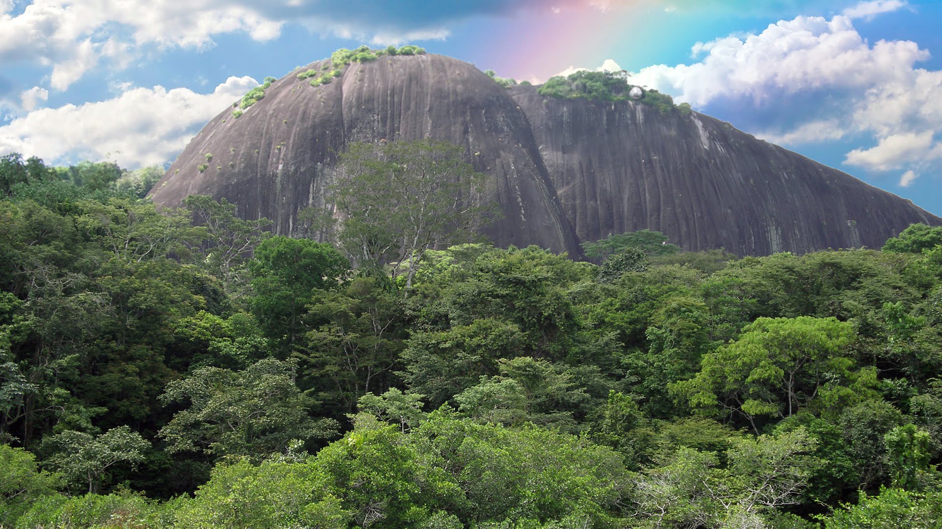
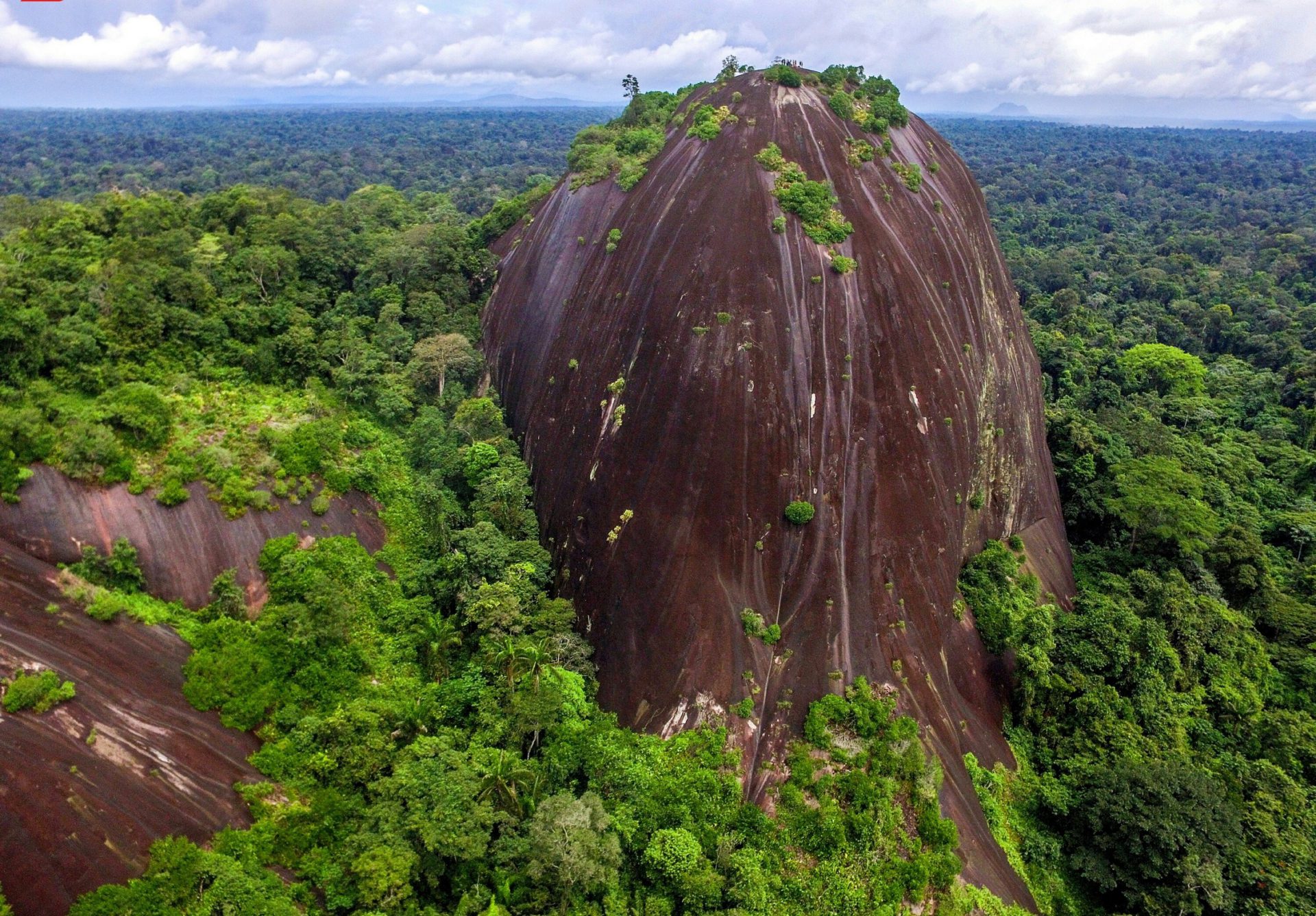
Granite domes are uplifted monoliths of granite rising high above the surrounding rainforest. The barren dark-colored granite exposed to the sun creates a unique xerophytic biotope that includes endemic plant species. The best-known granite dome is the 245 m high Voltzberg in the Voltzberg Nature Reserve at Raleighvallen.
Julianatop (1230 m), the highest mountain in Suriname, the Tafelberg (Table Mountain, 1026 meters), the Hendriktop (908 m), the Van Stockumberg (360 m), and Duivelsei (Devil’s Egg), a rock seemingly balanced on the edge of a mountain.
Raleigh Vallen Nature Preserve. Raleighvallen, or Raleigh Falls, is a 56,000-hectare (140,000-acre) nature reserve on the Coppename River, rich in bird life.
Tafelberg Nature Reserve – around the source of the Saramacca River, Tafelberg Mountain in the centre of the country is surrounded by its own reserve.
4-DAY/3-NIGHT TOUR
Many tour agencies in Paramaribo may be able to help organize a tour (Mets Travel & Tours Suriname). Four people are necessary to run a tour. They arrange bus/car to Witagron and the boat up the Coppenane River. Stinasu runs the accommodation on the island and this is also arranged by the tour company. I could not contact them. I found it impossible to independently organize a tour – I couldn’t find the bus to Witagron and the boat trip must be arranged with locals.
Day 1: Depart at 8 am by car or bus 4-hours to Witagron. Buses leave for Witagron on Fridays and Sundays from Saramacca Street at 8 am, 5 hours. Take a boat up the Coppenane River for 4 hours to Foengoe Island, the base camp of the trip.
Fungo Island Lodge (16-bed house, 12 rooms, unlimited hammock space (421683/476597; stinasu@sr.net). An all-wood, self-catering lodge on the rocky southwest shore of the 2 km long Fungu Island overlooking Raleigh Falls. Nature fee. Can swim in a series of calm pools.
Stinasu has two other lodges on the island: Gonini River Lodge (private ensuite rooms), and Tamanua Lodge (cheaper, an open-sided dormitory with shared facilities)
Hike locally, explore the island and swim in the Coppename River.
Day 2: Hike through the jungle to the Voltzberg, a 2-billion-year-old granite outcrop, 240m high. Challenging 14 km round trip to the top that takes a better part of a day. Departs from the east bank of the river a short boat ride upstream from the lodge, the first 5 km flat through the forest, cross a few streams to the base then a steep 20-40 minute scramble to the top, climbing forbidden after rains as the rock gets very slippery. See monkeys, birds, wild boars, and other animals and birds. Visit the Cock of the rock lek (communal display and breeding ground) near the base of Voltzberg. On the way back, swim at Ajoemara Falls before you arrive at the lodge.
 Day 3: Depart by boat for two hours to Lolopasi the nearest Maroon village and see the Mother Fall, a low, long staircase of cascading water on the upper Coppename River. Resident wildlife includes spider monkeys, electric eels, and the cock-of-the-rock. Return to Fungo Island.
During the free afternoon, can swim, fish, sunbathe, relax or walk to the airport to birdwatch. After dinner, see the sunset and possibly a cultural show of song and dance.
Day 4: At 10:00 am, leave by boat to Witagron and return to Paramaribo.
Kwamalasamutu. An Amerindian village near Suriname’s southern border with Guyana and Brazil. Fly from Paramaribo to Kwamalasamutu, a two-hour flight only once per week (so you are forced to stay for a week?).
American missionaries blazed the trail to Kwamalasamutu in the 1960s and gathered several tribes living around the forest into one village. Despite decades of contact with outsiders, the weekly sight of a plane dropping from the sky is still an event. Tourism is slowly reaching this remote outpost but is not yet developed to the point that the locals have painted faces, feathered headdresses.
A local Trio man stumbled upon a complex of cave dwellings a mile downriver from the airstrip and discovered a trove of more than 300 pre-Columbian petroglyphs carved into granite. Archaeologists flew in and found the oldest pottery stash in Suriname.
The villagers are trying their hand at ecotourism and have built two solar-powered lodges near the caves that can accommodate six guests and a traditional thatched round hut for dining. The indigenous-medicine clinic next to the village’s soccer field is where local shamans treat patients with medicines brewed from leaves, vines, and tree bark. Next door stands a concrete building that provides free primary healthcare. The two refer patients to each other, depending on the illness, and the result is an innovative community healthcare system in which traditional and Western practices are integrated and mutually respected.
SURINAME FACTS
HISTORY
Indigenous settlement dates back to 3,000 BC. The Arawak, a nomadic coastal tribe that lived from hunting and fishing were the first inhabitants. The Carib also settled in the area and conquered the Arawak by using their superior sailing ships.
Colonial period. Beginning in the 16th century, French, Spanish and English explorers visited the area. A century later, Dutch and English settlers established plantation colonies along the many rivers in the fertile Guiana plains. The earliest documented colony in Guiana was an English settlement named Marshall’s Creek along the Suriname River.
Disputes arose between the Dutch and the English for control of this territory. In 1667, after the Second Anglo-Dutch War, the Dutch kept Surinam. In return the English kept New Amsterdam, which became New York City.
In 1683, the Dutch West India Company relied heavily on African slaves to cultivate, harvest and process the commodity crops of coffee, cocoa, sugar cane and cotton plantations along the rivers. Planters’ treatment of the slaves was notoriously brutal even by the standards of the time and many slaves escaped the plantations. The Kingdom of the Netherlands governed after 1816.
With the help of the native South Americans living in the adjoining rain forests, these runaway slaves established a new and unique culture in the interior that was highly successful in its own right. They were known collectively in English as Maroons, literally meaning “brown negroes”, that is “pale-skinned negroes”. The Maroons often raided plantations.
Abolition of slavery in 1863, under a gradual process that required enslaved people to work on plantations for 10 transition years for minimal pay. When that expired in 1873, most freedmen abandoned the plantations in favor of Paramaribo.
To make up for a shortage of labor, the Dutch recruited indentured laborers from the Dutch East Indies (Indonesia) and India.
Decolonization. During World War II, the United States occupied Suriname to protect the bauxite mines. In 1954, Suriname a constituent country of the Kingdom of the Netherlands, along with the Netherlands Antilles and the Netherlands. Independence was granted in 1975.
Independence. In the years leading up to independence, nearly one-third of the population of Suriname emigrated to the Netherlands and Surinamese politics did degenerate into ethnic polarization and corruption. In 1980, a military coup overthrew Arron’s government followed by 4 counter-coups until 1982. 13 prominent citizens who had criticized the military dictatorship were held at Fort Zeelandia and were executed.
Civil war, elections, and constitution. The brutal civil war with the Maroons lasted from 1986 to the 1990s. More than 10,000 Surinamese, mostly Maroons, fled to French Guiana in the late 1980s. Bouterse remained in charge of the army and dismissed the government ministers in 1990, by telephone. In 1999, the Netherlands tried Bouterse in absentia on drug smuggling charges. He was convicted and sentenced to prison but remained in Suriname. In 2010, the former dictator Dési Bouterse was elected as the president and again in 2015. However, Bouterse was convicted by a Surinamese court in 2019 and given a 20-year sentence for his role in the 1982 killings. Chan Santokhi was elected in 1920.
Geography. Situated on the Guiana Shield between latitudes 1° and 6°N, it is divided into two main geographic regions. The northern, lowland coastal area is cultivated, and most of the population lives here. The southern part is tropical rainforest and sparsely inhabited savanna along the border with Brazil, covering about 80% of Suriname’s land surface.
Julianatop is the highest point at 1,286 metres. The six terrestrial ecoregions: Guayanan Highlands moist forests, Guianan moist forests, Paramaribo swamp forests, Tepuis, Guianan savanna, and Guianan mangroves. Its forest cover is 90.2%, the highest of any nation in the world.
Climate. Suriname has a very hot and wet tropical climate, and temperatures do not vary much throughout the year. The average relative humidity is between 80% and 90%. Its average temperature ranges from 29 to 34 degrees Celsius. Due to the high humidity, actual temperatures are distorted and may therefore feel up to 6 degrees Celsius hotter. The year has two wet seasons, from April to August and from November to February.
16% of the country’s land area is national parks and lakes.
Economy. After the turbulent 1990s, the economy became more diversified and less dependent on Dutch financial assistance. Bauxite (aluminum ore) mining made for 15% of GDP and 70% of export earnings. Oil and gold have added substantially. Agriculture, especially rice and bananas, remains strong. Ecotourism is providing new economic opportunities as more than 93% is unspoiled rain forest; with the establishment of the Central Suriname Nature Reserve in 1998, which became a World Heritage Site in 2000.
Rampant government expenditures, poor tax collection, a bloated civil service, and reduced foreign aid in 1999 contributed to the fiscal deficit, estimated at 11% of GDP. The government sought to cover this deficit through monetary expansion, which led to a dramatic increase in inflation. It takes longer on average to register a new business in Suriname than virtually any other country in the world (694 days or about 99 weeks).
Demographics. The largest ethnic group are the East Indians – 27.4%, descendants of 19th-century indentured workers from India. Afro-Surinamese 37.4%, divided into two cultural/ethnic groups: the Creoles and the Maroons. Maroons, whose ancestors are mostly runaway slaves that fled to the interior 21.7%. Creoles, mixed people descending from African slaves and Europeans (mostly Dutch) 15.7%. Javanese 14%. Mixed ethnic heritage 13.4%. Chinese, originating from 19th-century indentured workers 7.3%. Indigenous peoples 3.7%. A small but influential number of Europeans remain 1% and descended from Dutch 19th-century immigrant farmers and to a lesser degree other European groups, such as Portuguese. Many Boeroes left after independence in 1975.
90% live in Paramaribo or on the coast.
Emigration in 1975 led to a mass migration to the Netherlands with 350,300 living there.
Many Suriname-born football players and Dutch-born football players of Surinamese descent play for the Dutch national team. Cricket is popular to some extent,
Transportation. Along with neighboring Guyana, drive on the left. Road’s length 4303 km (of which 1119 km are paved).
Health.
In 2017 the age-standardized death rate for all causes was 793 (males 969, females 641) per 100,000 (1219 of Haiti, 944 of Guyana, 424 of Bermuda).
Tourism. Most tourists visit Suriname for the biodiversity of the Amazonian rain forests in the south of the country, which are noted for their flora and fauna.
See
Other attractions include plantations such as Laarwijk, which is situated along the Suriname River. This plantation can be reached only by boat via Domburg, in the north-central Wanica District of Suriname.
Suriname – North (Paramaribo, Brokopondo, Albina)
M@P: Baboon Islands (Big and Little)
Tentative WHS: The settlement of Joden Savanne and Cassipora cemetery (30/06/1998)
Islands:
Ile Portal
Papegaaien Island
Borders: Suriname (sea border/port/river)
XL: Kwana island
Roads, Road Bridges and Tunnels: Road – Albina-Paramaribo-Nieuwe Nickerie Road
House Museums/Plantations: Plantation Frederiks Dorp
Monuments: Marienburg: Indonesian arrival monument
World of Nature
Bigi Pan Park
Brownsberg Nature Park
Coppename Nature Preserve
Galibi Nature Reserve
Wia-Wia Nature Preserve
Waterfalls: Blanche Marie Falls
Lakes: Brokopondo Reservoir
Rivers
Maroni/Marowijne River
Saramacca River
Festivals
Pagara Estafette
Suriname Jazz Festival