
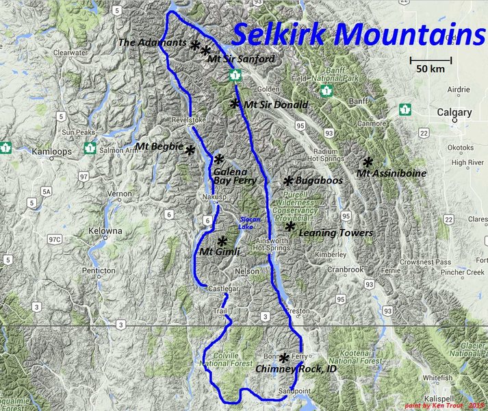
SELKIRK MOUNTAINS
Together with the neighbouring Monashee and Purcell Mountains, the Selkirk Mountains are part of a larger grouping known as the Columbia Mountains that lie just to the west of the Rocky Mountains.
Boundaries: The northern portion of the Selkirks lies entirely within the Big Bend where the Columbia River makes a dramatic 180-degree turn towards the south. They extend approximately 350 km (200 miles) south to Mica Peak between Spokane WA and Coeur d’Alene ID. The range is bounded on its west, north and northeast by the Columbia River, or the reservoir lakes now filling most of that river’s course. From the Columbia’s confluence with the Beaver River, they are bounded on their east from north to south by the Purcell Trench, which contains the Beaver River, Duncan River, Duncan Lake, Kootenay Lake and the Kootenay River in southeastern British Columbia and the Kootenai River in Idaho. In the USA, the Selkirks span the northwestern portion of the Idaho Panhandle and northeastern Washington. Its east-west boundaries are the same as in Canada – the Columbia River to the west and the Kootenai River to the east. The Selkirks were named after Thomas Douglas, 5th Earl of Selkirk.
The southern end of these mountains is home to the only extant woodland caribou population in the contiguous United States.
Geology The Selkirks are 850 million to 1.5 billion years old, once an extremely shallow sea on the edge of an ancient continental plate. The sea received sediments from the many rivers that emptied into it. These sedimentary rocks are in many areas lightly metamorphosed. 100 million years ago, the North American plate began to move west, overriding the Oceanic Pacific plate. The denser oceanic plate was forced down and under. The resulting pressure and friction liquefied the rocks, forming magma, As magma is lighter than rock, it rose toward the earth’s surface, where it formed massive bodies of granite rock known as batholiths. The resulting uplifting of the earth’s surface resulted in mountains. During these compressions, the metamorphic rocks of the Selkirks were pushed eastward over the strong gneisses of the Monashees below.
It was not until the last hundred thousand years that the last ice age covered the entire Selkirks. The 4000-foot-deep ice cut and shaped the mountains and dug out the deep valleys. Selkirk peaks offer a wide variety of climbing and hiking opportunities with remote summits and rock climbing.
The Selkirks are divided into two geographically separate areas with the dividing line Trout Lake and the Lardeau River where it enters the Duncan River. The transportation corridors for each area are also completely separate.
1. SELKIRKS NORTH
The Northern Selkirks have much more mountaineering interest than their southern counterpart. They are not considered in this e-book. David Jones has written two excellent guidebooks to this area: Selkirks North and Selkirks South. They are further divided into a north and south section separated by the Canadian Pacific Railway and the Trans-Canada Highway.
2. SELKIRKS SOUTH
Extend south from the CPR and the Trans Canada Highway to Trout Lake and the Lardeau River that empties into Kootenay Lake. Ranges are:
Rogers Pass Area. Rogers Pass roughly bisects Glacier National Park halfway between Revelstoke and Golden. To the North is the Hermit Range, part of Selkirk North. South are the following ranges:
Sir Donald Group. Bounded on the south and west by the Illecillewaet Neve and River and to the east by the Beaver River. Maps: 82N/6 Blaeberry, 82N/3 Mt Wheeler and 82N/5 Glacier. Has firm quartzite that offers exceptional climbing. , Asulkan Group. This is a small group of peaks along a ridge bounded by Loop Brook on the west, the Incomappleux River to the SW and the Illecillewaet Neve and River to the north and east. Maps: 82N/4. The rock is good quartzite and slate.
Bonney Group. Bounded on the north by the Illecillewaet River, on the east by Loop Brook, on the south and SW by the Incomappleux River and on the west by Flat Creek. Maps: 82N/4 Illecillewaet. Good quartzite, slate and pockets of limestone.
Albert Group. A diverse and extensive group of peaks bounded n the wst by the Columbia River, on the north by the Illecillewaet River, and on the east by the Incomappleux River and Flat Creek. Other than the peaks between Albert Peak and Charity Peak, the mountains are of little interest. Maps: 82N/4 Illecillewaet, 82L/16 Revelstoke and 82K/13 Camborne. The geology is wildly diverse because of the folding, faulting and intrusion of granite stock.
The Deville Ranges: Dawson Group, Bishops Group, Purity Group, and Sugarloaf Group border the Deville Glacier. All the peaks in this range lie within Glacier National Park. Map: 82N3 Mt Wheeler.
There are three general access routes: via a traverse of the Illecillewaet Glacier, via the Beaver Valley or by way of the Four Passes Route.
Battle Range: Ranges are the Melville, Westfall and Nemo Groups. The almost impenetrable bush, steep valleys and rugged terrain stopped all but the most persistent mountaineers. Even today, despite logging roads, the final approaches through dense bush presents formidable challenges.
The majority is composed of granite, some of it firm, but most fractured into many blocks more typical of alpine settings.
There are four access points from the north but only one from the south and the West Kootenay – the Duncan Forest Service Road.
Badshot Group: Bordered on the north by the apex formed by the Incomappleux River and Boyd Creek-Westfall River, and on the south by the Lardeau River-Duncan River confluence. Maps: 82K/13 Camborne, 82K14 Westfall River, 82K12 Beaton and 82K/11 Trout Lake. The poorest rock in the entire Selkirks with rock that is rotten and highly shattered. Prospectors had probably climbed all of the non-technical summits by the turn of the century.
WEST KOOTENAY SECTION of the SELKIRK MOUNTAINS
This part of the Selkirks contains the most southerly summits of the Columbia Mountains to have attracted the interest of mountaineers.
Boundaries to the north are Trout Lake and the Lardeau River, which form a large valley running southeast from Beaton on Upper Arrow Lake to Meadow Creek on the isthmus between the southern end of Duncan Lake and the north end of Kootenay Lake. Kootenay Lake forms the east boundary and Arrow Lakes (the Columbia River) determines the western border.
The region is split roughly down the middle by the Slocan Valley that proceeds SE from Nakusp on Upper Arrow Lake and then south along Slocan Lake and Slocan River that joins the Kootenay River not far west of Nelson.
MOUNTAINS NORTH and EAST of SLOCAN LAKE
Lardeau Range. A large area, it is bound on the west by Upper Arrow Lake, on the NE by Beaton Creek, Trout Lake and Lardeau River, and on the south by Kuskanax and Poplar creeks. Only in the SE do the peaks cluster, the rest of the area consists mostly of forest, with peaks not exceeding 2000m. Although this group is seldom visited now, many peaks were probably climbed by prospectors at the turn of the century. Maps: 82K/6 Popular Creek, 82K/12 Beaton, 82K/11 Trout Lake, and 82K/5 Leon Creek. Upper Arrow Lakes Forest Service Brochure.
Goat Range. Boundaries are Kuskanax and Poplar Creeks on the north, Seaton Creek and Kaslo River on the south, the Slocan Valley on the west and Lardeau Creek and Kootenay Lake on the east. Maps: 82K/3 Roseberry, 82K/6 Poplar Creek, 82K/2 Lardeau, 82K/7 Duncan Lake, 82K/4 Nakusp, and 82k/5 Trout Lake.
The glaciers have undergone considerable retreat in the 20th century. There is a large healthy glacier on the NE side of Mt Cooper, the only peak that exceeds 3000m. The area around Whitewater Creek, Marten Mountain, Mount Dolly Varden and Mount Cooper are all grizzly bear habitat.
The entire area was a centre of mining exploration and activity around the turn of the century. Everything (including Mt Cooper) between the Slocan River and the Kootenay-Duncan system had been climbed before 1925.
Kokanee Range. It is separated from the Goat Range to the north by Seaton Creek and Kaslo River. Slocan Lake and Slocan River bound it on the west and Kootenay Lake, on the east. The west arm of Kootenay Lake delimits the range on the south. Several serrated ridges over 2740m support small glaciers. The largest of them, the Kokanee, is some 5 square kilometres in area. The region features many small, scenic lakes. The relief is great, attaining 2260m above Kootenay Lake. Practically all the alpine-type peaks are included within the boundaries of Kokanee Glacier Provincial Park.
Bonnington Range. Bounded on the north by the Kootenay River, on the west by the Columbia River, on the south by the Trail/Salmo Corridor and on the east by the Salmo/Nelson Corridor. They contain 4 huts well known as an alpine skiing circuit.
Nelson Range. Bounded by the West Arm of Kootenay Lake on the north, Highway 3 to the south, the Salmo/Nelson corridor to the west and Kootenay Lake to the east.
MOUNTAINS SOUTH and WEST of SLOCAN LAKE
Valhalla Range. Composed of northern and southern portions divided arbitrarily by a line running northeast-southwest between Mt Bor and Black Prince Mountain. Boundaries on the east by Slocan Lake and River, on the south by Koch Creek, on the west by Burton Creek and the valley of the Columbia River (Arrow Lakes). Access is difficult but there are magnificent granite walls.
Maps: 82F/13 Burton, 82F/14 Slocan, 82K/4 Nakusp, 82K/3 Roseberry.
Valkyr Range. High ridges and basins with a few individual peaks and no permanent snow. Trees are found near most summits. The rock is very solid and smooth on outcroppings and faces. Valleys are steep and heavily wooded, and trails are scarce and overgrown. Maps: 82F/13 Burton, 82F/12 Passmore, 82E/16 and 82E/9.
Norns Range. A subrange of the Valkyr Range of the Selkirk Mountains located southwest of the junction of Little Slocan River and Slocan River north of Castlegar. The Norns were the Fate in Scandinavian mythology
Selkirks in the USA. Bounded by the Columbia River on the west, the Spokane River on the south and the Kootenai River on the east. The western part of Washington state has only a few mountains without trees on the summits. The eastern part of Idaho forms the Selkirk Crest.
In the centre of Idaho, large amounts of granite intruded forming the large Idaho Batholith covering 300 miles (N to S) by 100 miles E to W). The Kanisku Batholith is the foundation of the Selkirk Mountains. This batholith has since eroded into the present-day mountain terrain but is still covered by extensive amounts of exposed sedimentary and metamorphic rock.
Although the Pleistocene Ice Age began 2.5 million years ago, it was not until the last hundred thousand years that the ice moved out of BC and invaded Idaho to cover the Selkirks, Purcells and Cabinet Mts. The 4000-foot deep ice cut and shaped the mountains and dug out the deep beds of Priest, Pend Oreille and Coeur d’Alene lakes.
While the highest point of the Selkirks reaches only 7,670 feet (Parker Peak), valley-to-summit elevation differences are nearly 5,000 feet in places and the terrain is extremely rugged.
Two areas of significance are the Long Canyon area west of Bonners Ferry and the Salmo-Priest Wilderness area near the Canadian/Washington/Idaho borders. The latter is home to both the grizzly bear and the rare mountain caribou. Both are pristine and worthy of protection on scenic, recreational and wildlife management grounds.