
VANCOUVER ISLAND ROAD TRIP
This is a compilation of several road trips around Vancouver Island.
Courtenay/Comox
HIKES
Nymph Falls – Forbidden Plateau
RIVER SNORKELLING CAMPBELL RIVER (salmon run) Each fall millions upon millions of salmon return to the coast of British Columbia, and the rivers of their birth. Massive runs of salmon head up the Campbell River on Vancouver Island to their freshwater spawning grounds, including Coho, Steelhead, Chum, Chinook and Pink salmon. Viewing this natural spectacle from river banks is a wonderful experience, but the migrating salmon can be viewed in a whole different light by snorkelling on the Campbell River.
Snorkeling in the Campbell River allows swimming with salmon in their natural habitat as they swim upstream toward the gravel spawning beds. A vital spawning stream, the Campbell River drains 1,460 square kilometres in its journey from Vancouver Island’s rugged interior mountains to where it empties into Discovery Passage. The bottom of the river is rocky, with depths of up to 3 metres (10 feet) in the deeper parts, allowing for easier and unobstructed floating.
To protect the shallow gravel spawning beds and avoid disturbing the spawning salmon, snorkelers enter the river below the Quinsam River. The preferred put-in spot at the logging bridge on the Gold River Highway 28 allows easy and safe access to the water from a sandy shoreline and a slow-moving pool.
Take out is at the end of Maple Street, behind the Quinsam Hotel, or a slow moving deep water tidal pool in the estuary, which is often visited by harbour seals looking for easy prey as salmon get trapped following the tides in and out of the river. The huge rocks that mark the banks of the river make exiting easy.
Wet suits are recommended, as the Campbell River isn’t really warm, and the additional flotation enables the snorkeler to float high in the water and be carried over and around obstacles. Lying quietly in the water and drifting with the current will not bother the salmon, and more fish will be seen – splashing and diving will scare them away. Snorkeling is best on sunny days, when the fish are more spectacular in the bright sunlight, with their colouring bright and shining. Trout and crayfish can also be seen.
Types of Salmon
Chinook Salmon (Spring, King, Blackmouth or Tyee). The most-sought-after sport salmon, they reside in the deep ocean for 4 to 7 years before returning to their birth river. A Tyee is a Chinook salmon greater than 30 pounds (14 kilograms). The size range is 5-30+ pounds with many mid-twenties being common June through August.
Coho Salmon (Silvers). Start arriving in June. Hard-hitting acrobat that range in size from 4-20 pounds.
Sockeye Salmon (Red Salmon). Spawn in lakes and small feeder streams. Their young live in lakes for a year or more before making their way to the open ocean and are mostly plankton feeders. Prized for their bright red flesh and are commercially the most valuable Pacific salmon. They range in size from 5-12 pounds and can occasionally exceed 15 pounds.
Pink Salmon (“Humpies”). Arrive in large numbers and on odd-numbered years (eg. 2017 or 2019) they migrate in the millions. They are the smallest Pacific salmon, averaging 3.5 pounds (1.6 kilograms) to 5 pounds (2.1 kilograms) and can reach 12+ pounds.
Chum Salmon (“Dogs”, Keta, or Calico)/ Second largest and the latest salmon to arrive in Campbell River – start in August and peak throughout October. Toughest fighting salmon and average 8-20 pounds.
Horn Lakes Cave. Open 9:30-5:30. Two options of tours: Multicave Explorer $79, Riverbend Cave $54.
Horne Hustle
Englishman River Falls PP
3kms hiking including spectacular loop along the river and beside a canyon to viewpoints near two great waterfalls.
Access: From Highway 19, take the Port Alberni turnoff (exit 51) to Highway 4A. 3kms to turn to park at Errington Road, then 8kms on Errington Road to park.
Coombs. Old Country Store and goats on roof. Stop at this great specialty product store.
Little Qualicum Falls PP
Follow a loop around the lower and upper falls on good wide trails. Take two viewpoint trails to see each waterfall from its best perspective. Follow close to the fence lines.
Best in the spring and after big rains. The gorge itself is mediocre and the upper falls the better of the two. This loop takes only 45 minutes. The other several kilometres of trail service the large camp grounds.
The forest is mainly second growth with only a few large broken off trees. Large arbutus trees (the only evergreen broadleaf tree in Canada) are randomly distributed through the forest.
Access: From Highway 19, turn onto Port Alberni highway 4 for 9kms to entrance, 1.3kms to parking lot.
Camp Night 1 at Mt Cokely parking area.
Climb Mt Cokely (5301’). A satellite peak of Mt Arrowsmith and the mountain of the old Arrowsmith Ski Hill, views from the top include Georgia Strait to the east and Port Alberni to the west.
Drive: Access old ski hill access road. Turn left (south) off Hwy 4 just west of the Alberni Summit. Turn left on the far side of a bridge and drive up the valley back over the Cameron River, take left fork up steep road onto Pass Main. Continue up switchbacks to a hairpin turn. Drive up the valley turning left at saddle between Mt Cokely and Arrowsmith, through the gate and park at the ski area. Climb runs up the NW ridge.
Cathedral Grove
In 1944, the forester HR MacMillan donated this land to the province. Since it has become one of the most beautiful spots in Canada, and draws approximately half a million visitors annually. 132-hectare grove of giant Douglas fir, many over 800 years old (largest 9m circumference) and Western Red cedar. In MacMillan PP. A 1997 wind storm blew over hundreds of trees.
Logging has come right to the border of the park, removing the natural wind barrier. Global warming will dry out this area, placing stress on the cedars and hemlocks. The park’s small size and accessibility has left it vulnerable to impacts from high visitor use.
Camp Night 2. Drive To Carmanah Valley and camp.
CARMANAH WALBRAN trails. (Map 8/E6). Carmanah Walbran PP and Pacific Rim NP
Carmanah Provincial Park were created in 1990 to protect the lower Carmanah Valley. In 1995, after years of logging blockades and protests, the upper Carmanah and lower Walbran were added to form Carmanah Walbran PP. The park offers protection to diverse forest ecosystems, including a large Sitka spruce ecosystem that represents 2% of BC’s remaining old-growth forest.
The spruce groves in the park are about twice as dense in biomass as a tropical forest. 36 bird species including the marbled murelett (Carmanah Valley was the first place to record marbled murelett nests.
The central Walbran was designated a special management zone (environmental, cultural, and recreational values at core of harvesting plans; require more old growth retention and smaller cut blocks; “old growth logging by another name”). In 2014, flagging tape was found at the unprotected Castle Grove (Surrey based Teal-Jones Group). Trees already logged to build roads. It is contiguous with the provincial park, but its trees are spectacular in size, abundance and structure.
Carmanah Walbran is home to some of the world’s largest spruce trees, some reaching heights in excess of 95 metres and living for 800 years or more. The park is also home to ancient, gnarled cedars – estimated to be well over 1,000 years old – clinging to the side hills. Nestled beneath these awe-inspiring trees is a diverse variety of flora and fauna possible only in an ecosystem that has remained undisturbed for hundreds of years.
Sitka spruce forests are typically coast-hugging – they are rarely found more than 80 kilometres inland and at elevations greater than 30 metres. The park’s extensive groves of spruce attain a biomass (weight of plants per hectare) that is nearly twice that of a tropical forest.
The park is a wilderness area. Trails are primitive and very muddy. Carmanah Walbran has no gas, food, roofed lodging, telephone or medical services. Gas, food and telephone service are available at the Didtidaht Nation Centre located in Nitinat, approximately 20 km from the park. The primary destination point of visitors to the park is the Park Facility Operator’s station, located at the lower Carmanah Valley Trailhead. This area offers parking, pit toilets and walk-in camping above the valley.
National Topographic Series map number 92, sheets C/10 and C/15 cover the Carmanah Valley area.
Drive: There are three different routes leading to the Caycuse River Bridge, which is the only way to access the park.
1. From Port Alberni follow the Bamfield Road for approximately 40 km to the Franklin River Junction, turn left onto South Main and proceed eastward, past the logging camp buildings and toward Nitinat Lake. Continue on South Main for approximately 23 km to the Nitinat River Bridge. Stay on South Main until reaching the Caycuse River Bridge.
2. From Port Renfrew follow the Lake Cowichan Connector Road north to Honeymoon Bay. At Honeymoon Bay, turn left and proceed along South Shore Road, which becomes Nitinat Main, continuing to the junction of Nitinat Main and South Main. Turn left onto South Main and proceed to the Caycuse River Bridge.
3. Via Lake Cowichan follow South Shore Road past Gordon Bay Provincial Park to the Nitinat Main, or follow the North Shore Road through Youbou to the Nitinat Main. Continue along Nitinat Main till it connects with Junction South. Turn left onto South Main and proceed to the Caycuse River Bridge.
Once you have crossed the Caycuse River Bridge, turn right immediately and proceed on Rosander Main for approximately 29 km to the park.
From SE corner of Port Alberni > Franklin River Rd/Bamfield Main > Carmanah Main > Rosanger Main (on south side of Nitinat Lake)
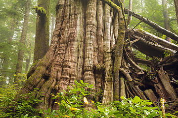
Cheewhat Lake Cedar (Cheewaht Giant) (Map 8/C7)
Canada’s largest tree, world’s largest Western Red cedar: 18.34m (60.2’) circumference, 55.5m (182’) high.
There are bigger trees in the world, but the Cheewaht Giant is the Big Doodah, the Numero Uno, the Colossus of trees in Canada. Located off a series of unpaved logging roads southeast of Port Alberni, the humungous red cedar was found in 1988 by Maywell Wickheim who’d spent his life searching for the country’s biggest tree.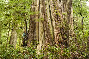
Cheewhat Lake is tucked into the southern portion of Pacific Rim National Park Reserve.
The lake is largely trail-less but a few of the largest trees grow on the eastern end and can be accessed by the short Cheewhat Lake Cedar Trail. The trailhead is very easy to miss unless you know to look for it. There are a few bits of flagging tape on both sides of the road and a small cairn to mark the entrance.
Rosander Mainline will traverse the hillside above the east shore of Nitinat Lake, climbs steeply, then drops into the Marchand Creek valley. The road winds down into the valley, then after several bridges rises gently. After a wide clearing the road enters a logged area. Park safely off the road at the first widening of the road on the right after entering the clear cut. Nearby a rough, overgrown track leads down into the clear cut.
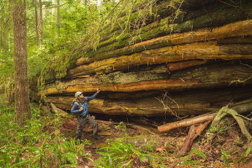
Follow this track down and across the slash. As the track rises slightly and bears left along the edge of the old-growth forest that marks the boundary of Pacific Rim National Park Reserve, look for a huge cedar stump 4.6m (15ft) across. Ring counts of this stump totaled 968 years. Another stump nearby has 1212 intact annual rings, plus it has a hollow center – this tree could have been as old as 1400 years when it was cut down.
The Cheewhat Lake trail is roughly marked with flagging, but it is easy to lose ones way here. The trail begins near an area of blow down along the park boundary, and the initial start to the trail is obscured with fallen trees. After carefully negotiating your way over, under, and around the downed trees, the trail will descend to the right through the blow down. Pick up the trail again at a flat covered with ferns and huge cedars. The largest tree in this grove is over 4.6m (15ft.) thick, but the grove itself has been affected by more blow down due to inadequate park buffer zones. Beyond this grove carefully follow the vague and poorly marked trail. It heads to the right over a low ridge, then doubles back to the left along a bench land through dense salal and cedar-hemlock rain forest. The trail will turn downhill and passes two Western red cedars growing by each other. The bigger of the two is 5.5m (18ft.) in diameter.
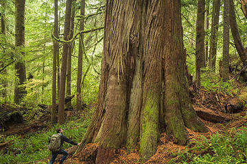
A short distance downhill and left you will find the awe-inspiring pinnacle of The Cheewhat Lake Cedar. This champion tree is 6.0m (19.7ft) in diameter, circumference of at least 18.34 meters (60 feet) and 59m (194ft) tall. The tree has 450 cubic meters of timber volume. Nearby are many other large cedars scattered through the original, wild forest.
Using a hollow auger on a nearby fallen cedar, and extrapolating from that core’s tree-ring count to the Cheewaht Giant’s diameter, it is calculated to be 3,500 years old. The small grove near the Cheewhat Lake Cedar is perhaps the most striking with several redwood-sized specimens.
Cheewhat Lake
There is another giant tree, the third largest tree and north of the lake. The trailhead is even harder to find. Take Roseander Main north, turn left towards Doobah Lake on logging road T23B a few kilometres to a barely flagged entrance. The rough trail leads to the north Cheewhat shore but to reach the tree, you need to bushwhack slightly east. This definitely primordial-looking western red cedar is likely a result of fusion between two independently huge trees hundreds of years ago.
CARMANAH WALBRAN PP
Road access (Rosander Main) to the lower Carmanah Valley is currently open and very rough but not guaranteed, please note that alder growth just prior to the park entrance is causing the road to be brushed in, but is passable. Flat tires are common so have an electric pump, spares and preferably 10-ply tires.
Carmanah Giant is a 95m (312’) high, the tallest known tree in Canada and believed to be the third tallest Sitka spruce, 31’ circumference. Estimated to be less than 400 years old, it is the tallest known Sitka Spruce in the world. Surrounded by 90m (280’) spruce and thousand-year-old cedars. Growing in a ravine near the bottom of the lower Carmanah Trail, which is officially closed.
Carmanah Creek. A variety of viewpoints can be reached from the main trail, which leads up and down Carmanah Creek from the Carmanah Valley Trailhead. The whole Carmanah Valley is 20km long and difficult as the trail is not maintained.
TH at parking lot – trail switchbacks steeply down to the valley floor and the Carmanah Creek junction at 1.3km. Just before the junction is the Coast Tower. 25 min one way.
Coast Tower: 1.2 km, 20 minutes. A massive Sitka spruce used to be 92 metres in height until the top 30 metres blew off in winter storms in 1997.
Junction: 1.3 km, 25 minutes. Turn left to go to the Upper Valley Trail, which heads toward Three Sisters, Grunts Grove, Paradise Pool and August Creek. Turn right to head downstream toward Heaven Tree and the Randy Stoltmann Commemorative Grove.
Upstream (distances are from the Carmanah Creek junction 1.3kms from parking lot)
• Three Sisters Grove: One of the trees fell naturally during the winter of 2018/19. 70 minutes upstream from the Junction. An elevated viewing platform gives a unique perspective of three breathtaking Sitka spruce trees, all growing from the same spot. These trees are approximately 78-79m high. Wilderness camping is allowed here on the large sandbar beside Carmanah Creek. Pit toilets. The boardwalk portions of the trail end after Three Sisters.
• Grunt’s Grove: 4 km and 1.5km above Three Sisters. 1.25 hours from the Junction. Majestic stand of Sitka spruce with adjacent camping on gravel bars. Spruce seedlings typically start their life on the sandbars in Carmanah.
• Paradise Pool: 5 km. 2 hours from the Junction. Paradise Pool is a small crystal clear pool with tiny Cutthroat trout and crayfish. Cougar tracks can often be seen in the mud. Too cold to swim.
• August Creek: 7.5 km. 3.5 hours from the Junction. August Creek is a small intact watershed that flows into Carmanah from a high reverse valley. It is the largest creek that flows into Carmanah. Backcountry camping opportunities exist on the sandbar just downstream of the confluence of August and Carmanah Creek. There are no pit toilets here. This is the most upstream campsite in the valley; maintained trails end at August Creek.
•Walbran Falls: 15 minutes upriver. Tiered waterfalls and good swimming pools.
Downstream
• Heaven Tree: 0 km, 30 minutes downstream from the Junction. Sitka spruce 77m tall, diameter of 3.5m, one of the broadest spruce trees
• Randy Stoltmann Commemorative Grove:3 km. 50 minutes downstream from the Junction. 75 – 89 metres in height. These trees all compete for light and are growing tall as they reach for the sun. The terminus of the downstream trail. Closed for public safety reasons. No trail connection to the West Coast Trail.
Wilderness camping is allowed at several locations upstream from The Three Sisters in the Carmanah Valley, with walk-in camping available above the Valley where the Carmanah Valley Trailhead is located.
Camping is also permitted during the summer months in the valley on the Carmanah Creek’s exposed gravel bars. Campfires are prohibited here.
Campsites with tent pads, picnic tables and fire rings are provided beyond the parking area on the service road. Short-term vehicle camping is permitted in the parking lot.
A backcountry camping fee is charged at Carmanah Walbran; self registration vaults are located in the parking lot at the Carmanah Valley Trailhead.
Campfires are only allowed in the steel fire rings located in the campsites along the service road and in the area near the Carmanah Valley Trailhead. Campfire time restrictions are in effect: Cooking fires are allowed from 7:00 am – 9:00 am; 11:00 am – 1:00 pm; and 5:00 pm – 7:00 pm; small campfires after 7:00 pm. Campfire rings are provided.
UPPER WALBRAN
Larger and equally interesting. Take a left fork at the Cayuse Bridge. Best access is via McClure Main and Glad Lake Main. Has been logged for years but still much old-growth forest. The bridge on Walbran Creek near the park boundary makes a fine destination for car camping and day trips. Good trails, some with boardwalk, stairs, bridges and gorgeous river-side campsites.
Camping. 1. Best established campsite is at south entrance. 2. Hadiken Lake – dock, trail around lake, old growth
Emerald Loop Trail is the most accessible and family-friendly hike in the Walbran Valley. Situated parallel to the entry road into the valley, the trail is very short, fairly flat, and takes about 20 minutes to complete through old-growth trees next to the Walbran River.
The trail was first forged in the early 1990s by protesters who dedicated considerable effort to bringing tourism into the area, thereby preventing further logging of the valley trees. As tourists began to arrive, conservationists built the boardwalk to offset the erosive damage heavy foot traffic would cause the forest.
West Walbran Trail (Walbran Solidarity Trail). In the park but not a recognized park route. Walk through one of the best diversity of giant trees between two logging road accesses. It is a good day hike (either long or short depending on trail conditions). Gets overgrown. Expect a full day to do the trail end to end about 7kms. Most hike from the south access only.
North Access: near end of Haddon Main. At the Haddon-Walbran junction, stay on Haddon Main heading south for 6kms until junction with an old overgrown spur (second spur on the right, first is overgrown)
Haddons Corner. .5km. very large spruce.
Anderson Lake. mid-point of trail. Good camping, an old burled cedar. Kokanee.
South Access: 14km south the Haddon main junction. Take the last right turn off the main down a deactivated logging bridge that descends to the old and only logging bridge over the Walbran. The trail begins near the Harriet Nahanee Memorial Trail and the Castle Grove Trail , initially penetrating a forest of primarily western red cedar. Some of these giants are over 500 years old and have grown into incredible sizes and shapes with age. Upper Falls. Several tiers over bedrock. Salamanders.
Bridge Over Troubled Walbran. Once crossed by a cable car, then a log bridge, now a shallow placid wade. Trail leads from the end of the bridge along the creek to the main camping area. The transition from western red cedar to Sitka spruce is quite remarkable and unique among the various trails in and around the Walbran Valley.
One of the absolute largest of these spruces is “Maxine’s Tree”, the largest spruce in BC and second largest in Canada at 80.8m high and 12.65m circumference. Further on, near Anderson Lake, the trail becomes a bit harder to follow.
Harriet Nahanee Memorial Trail. Opened in 2016, this trail commemorates the life and conservation efforts of a heroic First Nations woman who was instrumental in preserving both the Carmanah and Walbran rainforest valleys.
Starting by the shores of the Walbran River, the trail initially passes by several huge western red cedars including the “Tolkien Giant” before climbing steeply. Its north side journeys through some equally gigantic, yet nameless, cedars that amazingly cling resiliently to the vertical slopes of this elevated hike.
The trail passes through cut blocks proposed by logging companies and hopefully helps raise awareness of the danger these pristine giants face to short-sided industry practices.
Castle Grove & Witness Trail. No other trail in Vancouver Island contains a higher concentration of monumental western red cedars than the magical Castle Grove. Located across the West Walbran Creek from the main Walbran Valley entrance, the Grove is situated on a rich alluvial flood plain – a perfect environment for the development of giant trees. The Grove’s largest specimen is an immense red cedar appropriately named “Castle Giant” that has grown to approximately 16 feet in diameter over hundreds of years. About a thousand years old and one of the largest trees in Canada.
On the eastern slopes above the Grove, conservationists have constructed a newer side path called the Witness Trail. Trees as large and tall as ones in Castle Grove are found here as well. Forming a loop up a hill, the path is a definitely thigh burner with an early near vertical ascent no matter which direction you approach it. Like the Harriet Nahanee Memorial Trail, the route was strategically located to take hikers across proposed cutblocks by timber companies, helping draw attention to potentially devastating losses and encourage tourism over logging as the Walbran Valley’s main economic driver.
Central Walbran: An arm of the trail goes to the Central Walbran to two lakes Botley and Auger Lakes
Drive from Walbran via Shawnigan Lake.
Kinsol Trestle. Shawnigan Lake
Drive: Public vehicle access is from Shawnigan Lake to the south end of the trestle. From Shawnigan Lake Road in the town turn north onto Renfrew Road. Follow it past the end of the Lake to Gleneagles Road and turn right. There is a public parking area about 550 metres down the road on the right hand side.
On Foot: From the parking lot on the south side, the Kinsol Trestle is approximately 1.2 km in distance on the Cowichan Valley Trail which is located on the old railway grade. The trail is wheelchair accessible and is flat, wide, and surfaced with crushed gravel fines. There are accessible toilet facilities at the parking lot and on the north side of the Kinsol Trestle that are open year round. The Cowichan Valley Trail is used to access the Kinsol Trestle from the north which is open for cyclists, hikers and equestrians.
Chemainus Murals After more than 120 years, the sawmill shut down in 1983 and from just five murals in 1982, there are now 44 huge depictions of the community’s history in an open-air museum.
As a direct result, Chemainus has attracted numerous new businesses, many thousands of visitors a year, a $3.5 million dinner theatre and a first-class hotel. From a dependence on a single industry, it has broadened its economic base to offer a range of services and tourist related activities. To everyone’s relief, the mill was rebuilt and modernized, and reopened in 1985. By that time, residents and visitors alike felt that they had proven they could survive the worst of times through their spirit and determination.
AROUND NANAIMO
Petroglyph Provincial Park, Nanaimo. The high concentration of prehistoric rock carvings is the main attraction here, located at the south end of Nanaimo just off Hwy 1. Dating from more than 1,000 years ago, the images – depicting everything from mystical wolf-like creatures to fish and human figures – were made for a variety of reasons, including territorial ownership and to commemorate special events among a people with no written language. The sandstone gallery of petroglyphs, located on a hill overlooking Nanaimo Harbour, is just a short distance from the interpretive area along the walkway.
Concrete replica castings of the petroglyphs can be found in the main interpretation area. Here, visitors can make rubbings of the castings by stretching cloth or paper across the carving and lightly rubbing with a crayon, charcoal or wax, which leaves a reverse imprint. These rubbings make a great souvenir of a visit to this intriguing and educational park.
Mt Benson
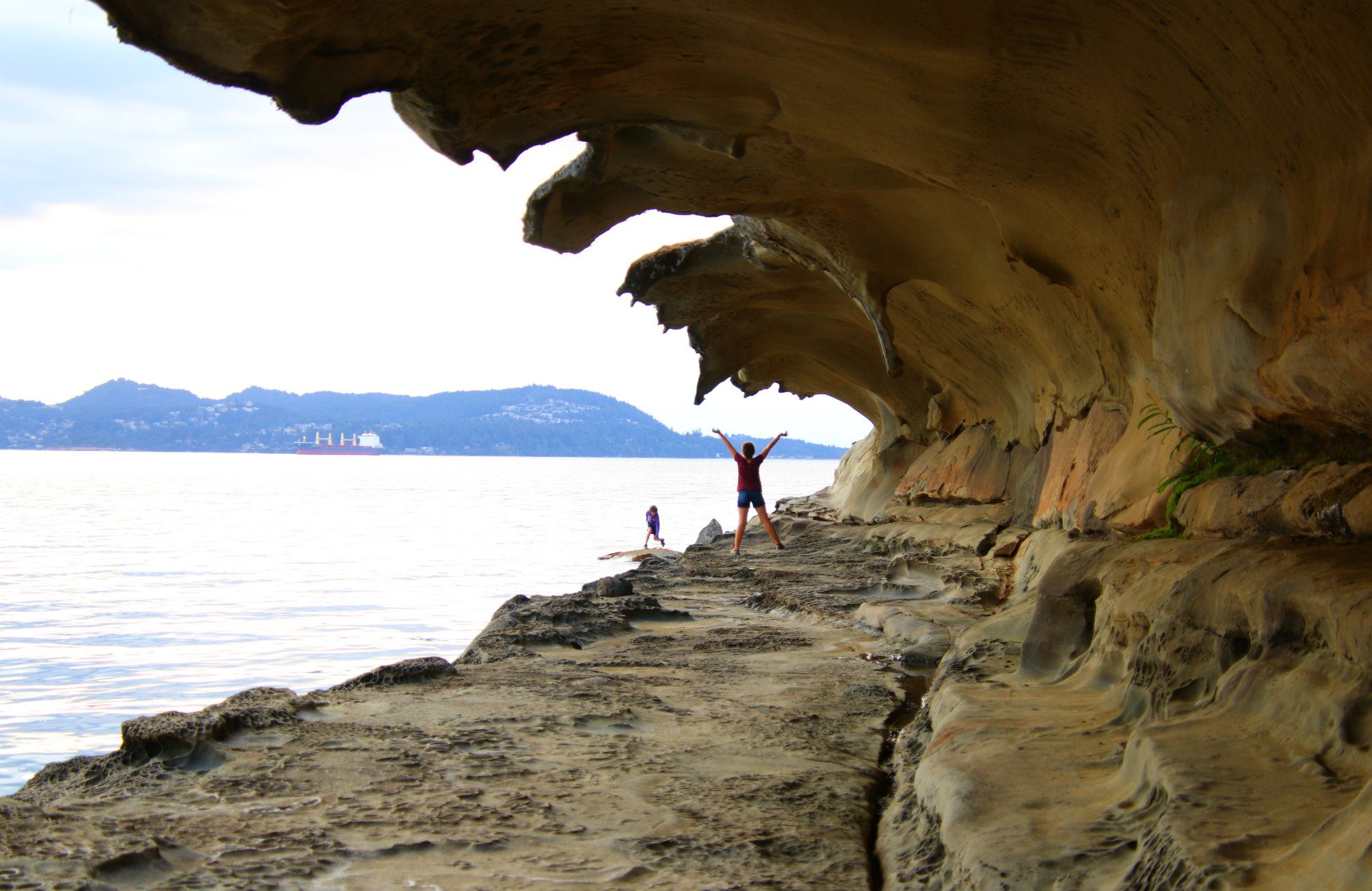
Malaspina Galleries, Gabriola Island. This isn’t your typical art gallery. Less than 10 minutes from the ferry terminal, these galleries show what a gorgeous art form nature can display. From years of stormy waters crashing on the sandstone along with freezing and warming temperatures, nature has created its own on-land rip curl. This impressive carving has the form of a barreling wave and is truly fascinating to see. It is a wonderfully visual way to appreciate the sheer power of water.
Wavelike formations exist all over the Gulf Islands, but these are the most well known. These are by many accounts the most impressive at 100m long, ideal because they are also the most accessible. The wave is nearly 4m tall, which means you can easily walk under it and observe the finer details of the rock structure.
Malaspina Galleries is a cool spot to explore no matter the time of day – sunsets and how the light changes on the rock formations. Bring snacks and water and enjoy spreading out on the massive smooth rocks and simply relax and soak in the island life.
 Moorecroft Regional Park, Nanoose Bay, a 34-hectare park featuring Western Red Cedar, Douglas Fir, twisted Arbutus trees, and endangered Garry Oak. If that’s not enough, add in a hike to The Notch, and end the day with a pint at a destination English pub – The Rocking Horse Pub.
From the Petro Canada gas station turn off the Island Highway (Highway 19) onto Northwest Bay Road. Turn right onto Powder Point Road and continue until you reach a four way stop. Continue straight as Powder Point Road then becomes Fairwinds Road. Look for the trail head on the right hand side of the road.
PARKSVILLE
Boardwalk
Rathtrevor Beach Provincial Park is one of the province’s most popular family destinations. Rathtrevor Beach is home to many resorts (along Resort Drive) and to the BC Provincial Park / Campground of the same name. The attractions include sea (five kilometers of beachfront), forest (complete with a circular, oceanfront trail) and parkland (including shaded picnic grounds and lots of space to knock a ball around). At low tide, the ocean recedes almost a kilometre back from Rathtrevor’s shoreline.
The Rathtrevor Beach Nature House is an interpretive centre and hub for environmental education.
As a Mountain Bike Park, the park is part of an off-road route that links the provincial park and resorts with a popular walking and swimming area on the Englishman River. Round trip distance from Rathtrevor is 10km.
Sand sculpting Festival. The Quality Foods Sand Sculpting Competition and Exhibition is a world class event for Master Sand Sculptors and is an official qualifying event for the World Championship of Sand Sculpting. Master Sand Sculptors travel from all corners of the globe to participate. Sculptors have 30 hours over four days to create their masterpieces from just sand and water. Well over 100,000 people visit during the festival.
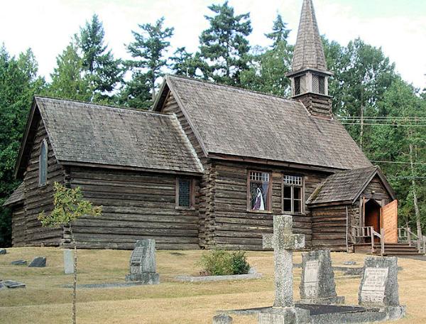
St Anne’s Anglican Church, Parksville. The pretty and beloved St. Anne’s Anglican Church in Parksville is one of Vancouver Island’s oldest churches (and the oldest surviving log church) built in 1894. Gravestones honour many new settlers who helped in its construction. St. Anne’s still has an active parish, though they use nearby St. Edmund’s for some services. Parish records show that the church’s first baptism was for Emily Jane Hume, daughter of Robert Hume and Charlot Emily Hickey, on August 12, 1894. The first wedding united Irish Catholic Thomas Kinkade and Sarah Coqulamat, a coastal First Nations widow, on October 24, 1896.
If you get the chance to visit St. Anne’s, it is a wonderful weathered log building. The stone font was donated by Mrs. Cooper in 1921 in memory of her husband Rev. Canon Charles Cooper. He first initiated the building of the church in 1893 – at the time there was no place of worship between Nanaimo and Alberni. The east window was a gift from E.B. May in 1938, in memory of his wife, Dorothy May.
Visit the gravestone of “baby Christina” – Christina Morison passed away at just 6 weeks old in July of 1897. Many graves have a plasticized write up telling the story of the inhabitant.
Monks Art Gallery.
Qualicum Beach Heritage Forest. 5 minutes from downtown Qualicum Beach are 50 acres of rare old growth forest – a mixture of Coastal Douglas Fir, Western Red Cedar, Hemlock, Grand Fir and Sitka Spruce. The park is centred on a lush ravine with a salmon stream. There are few truly large trees but it makes for a pleasant walk in the middle of a town.
NEARBY HIKES
HORNBY ISLAND
1. Mt. Geoffrey. Take island shuttle to trail head on east side, walk along edge, Ford Cove (on road), return Middle Bench or Lower Trail.
2. Halliwell Park
DENMAN ISLAND
1. Tree Island at low tide
QUADRA ISLAND
1. China Mts
2. Mt Seymour
COMOX VALLEY
1. Seal Bay: 2 separate trails systems in mature forest
2. Forbidden Plateau. Nymph Falls
3. Hart Creek (Washer Creek below road). Park at Union Bay Community Hall (just past creek). Lower down the creek is all boulders. Bypass on trail on right (at one junction take lower or right) that stays above creek. Eventually creek bed becomes a light brown sandstone full of potholes, rivulets, pools. Can swim. Gorgeous.
4. Air Force Beach.
Horne Hustle
CYCLE ROUTES
1. Up Comox Lake Logging Road down Lake Trail (faint trail between). All in the shade, short, fairly flat.
VICTORIA
History, Culture, National and City Museums: Royal BC Museum
Castles, Palaces, Forts
Craigdarroch Castle
Fort Rodd Hill and Fisgard Lighthouse
Hatley Park National Historical Site
The Empress
Art Museums: Art Gallery of Greater Victoria
House and Biographical Museums: Emily Carr House
Religious Temples: Christ Church Cathedral
Museums – Various: National Toy Museum of Canada
Botanical Gardens: Butchart Gardens
Zoos: Victoria Butterfly Gardens
Planetariums: Dominion Astrophysical Observatory
Theme Parks, ‘Fun’ Museums and Miniatures: Miniature World
Hospitality Legends
Six Mile Pub
The Empress Hotel
Maritime/Ship Museums
CFB Esquimalt Naval Museum
Maritime Museum of BC
Aviation Museums: British Columbia Aviation Museum
INFORMATION
peakbagger.com
alltrails.com
nwhikers.com/forums
lucascometto.com/cacada-vancouverisland
vancouverislandbigtrees.blogspot.com (south island)
BRTISIH COLUMBIA NM
Vancouver Island (Victoria)
M@P: Southern Gulf islands (Galiano, Salt Spring etc.)
History, Culture, National and City Museums
Campbell River: Museum at Campbell River
Nanaimo: Nanaimo Museum
Railway, Metro, Funiculars, Cable Cars: Alberni Pacific Railway
World of Nature
Cape Scott Provincial Park
Englishman River Falls Provincial Park
Gulf Islands NP
Pacific Rim NP
Sooke Mountain Provincial Park
Botanical Gardens: Tofino Botanical Gardens
Waterfalls
Englishman River Falls
Della Falls
Elk Falls
Caves and Sinkholes
Horne Lake Caves
Little Huson Caves
Trails 2 – Hikes: Wild Pacific Trail (Vancouver island)
Aquariums
Ucluelet: Ucluelet Aquarium
Campbell River: Discovery Passage Aquarium
Sidney: Shaw Centre for the Salish Sea
Beaches: Long Beach
Lighthouses
Fisgard Light
Ucluelet: Amphitrite Point Lighthouse
Victoria Seaport Lighthouse Museum
Ski Resorts: Mount Washington Skiing Alpine Resort
Villages and Small Towns
CHEMAINUS
Airports
CFB Comox (YQQ)
Nanaimo (YCD)
Victoria (YYJ)
======================================
British Columbia South (Vancouver, Quesnel, Kelowna)
World Heritage Sites: Canadian Rocky Mountain Parks
Tentative WHS: Stein Valley
Islands
Lulu (Richmond, BC)
Princess Royal island
XL
BC Southeastern (Mountain Range)
Strait of Georgia islands (Saltspring, Galiano etc.)
Airports
Abbotsford (YXX)
Kamloops (YKA)
Kelowna (YLW)
Vancouver (YVR)
Railway, Metro, Funiculars, Cable Cars
Fort Steele Heritage Railway
Hells Gate Airtram
Kettle Valley Steam Railway
Sea to Sky Gondola, Squamish
Whistler Blackcomb (Peak 2 Peak) Cable car
History, Culture, National and City Museums: British Columbia – Quesnel: Quesnel Museum World of Nature
Akamina-Kishinena Provincial Park
Broughton Archipelago Provincial Park
Bugaboo Provincial Park
Garibaldi Provincial Park
Glacier NP
Kokanee Glacier Provincial Park
Kootenay NP
Mount Revelstoke NP
Purcell Wilderness Conservancy
Valhalla Provincial Park
Yoho NP
Waterfalls
Spahats Creek Falls
Takakkaw Falls
Bridal Veil Falls
Helmcken Falls
Hunlen Falls
James Bruce Falls
Shannon Falls
Caves and Sinkholes: Cody Caves Provincial Park
Lakes
Berg Lake
Emerald Lake
Garibaldi Lake
Kootenay Lake
Quesnel Lake
Spotted Lake
Rivers
Columbia River
Fraser River
Trails 1 – Treks: Kettle Valley Trail
Trails 2 – Hikes
Panorama Ridge (Garibaldi Provincial Park)
Sea to Sky Trail
Festivals
Celebration of Light, Vancouver
Motion Notion
Music Waste, Vancouver
Salmon Arm Roots and Blues Festival
Vancouver Folk Music Festival
Theme Parks, ‘Fun’ Museums and Miniatures: Revelstoke: The Enchanted Forest
Beaches: Penticton: Skaha Beach
Open-Air Museums
Barkerville Historic Town
Britannia Mine Museum
Vernon: Historic O’Keefe Ranch
Well-being
Springs: Halfway River Hot Springs
Wineries: Mission Hill
Ski Resorts
Red Mountain Resort, Rossland
Whitewater Ski Resort, Nelson
Big White
Fernie
Revelstoke Mountain Resort
Sports Museums: Olympic Experience at Richmond Olympic Oval
Railway Museums
Cranbrook: Canadian Museum of Rail Travel
Revelstoke Railway Museum
Squamish: West Coast Railway Heritage Park
Vehicle Museums: Tappen: White Post Auto Museum
Bizzarium: Boswell: Boswell Glass House
Villages and Small Towns
NELSON
Railway, Metro, Funiculars, Cable Cars. Nelson Electric Tram
WHISTLER
Railway, Metro, Funiculars, Cable Cars: Whistler Blackcomb (Peak 2 Peak) Cable car
Art Museums: British Columbia – Whistler: Audain Art Museum
Festivals: World Ski & Snowboard Festival, Whistler
Ski Resorts: Whistler Blackcomb
Cities of the Americas
CHILLIWACK
KAMLOOPS
Railway, Metro, Funiculars, Cable Cars: Kamloops Heritage Railway
Zoos: Kamloops: Wildlife Park
KELOWNA
History, Culture, National and City Museums: Kelowna: Okanagan Heritage Museum
Zoos: Kelowna: Kangaroo Creek Farm
LOWER MAINLAND
Railway, Metro, Funiculars, Cable Cars: Fraser Valley Historical Railway
History, Culture, National and City Museums: Surrey: Museum of Surrey
Art Museums: British Columbia – Abbotsford: The Reach Gallery Museum
House and Biographical Museums: Abbotsford: Trethewey House Heritage Site
Religious Temples: Dewdney: All Saints Monastery
Zoos: Aldergrove: Greater Vancouver Zoo
Open-Air Museums
Burnaby: Burnaby Village Museum
Fort Langley National Historic Site
Malls/Department Stores: Tsawwassen: Tsawwassen Mills
Aviation Museums: Langley: Canadian Museum of Flight
Museums – Various: Richmond: Gulf of Georgia Cannery
NEW WESTMINSTER
History, Culture, National and City Museums: Fraser River Discovery Centre
House and Biographical Museums: Irving House
Military, War and Police Museums: The Museum of the Royal Westminster Regiment
VANCOUVER
Airports: Vancouver (YVR)
Railway, Metro, Funiculars, Cable Cars
Grouse Mountain Aerial Tramway
Pacific Western Station (Vancouver)
Rocky Mountaineer (Vancouver-Calgary)
Royal Canadian Pacific
The Canadian (Toronto-Vancouver)
Vancouver SkyTrain
Urban Legends
Robson Square
Seawall
Stanley Park
Roads, Road Bridges and Tunnels
Road – British Columbia Highway 3
Tunnel – Cassiar Tunnel
Tunnel – George Massey Tunnel
History, Culture, National and City Museums
Museum of Vancouver
Nikkei National Museum
Archaeology and Anthropology Museums: Museum of Anthropology
Architectural Delights
Harbour Centre
Vancouver City Hall
Art Museums
Bill Reid Gallery of Northwest Coast Art
Vancouver Art Gallery
House and Biographical Museums: Roedde House Museum
Religious Temples: Christ Church Cathedral
Science, Technology and all Industry Museums: Science World
Botanical Gardens
UBC Botanical Garden
VanDusen Botanical Garden
Natural History and Earth Museums
Beaty Biodiversity Museum
Pacific Museum of Earth
Aquariums: Vancouver Aquarium
Planetariums: H.R. MacMillan Space Center
Theme Parks, ‘Fun’ Museums and Miniatures: Playland
Beaches: English Bay
Hospitality Legends: Hotel Vancouver
Malls/Department Stores: Metropolis at Metrotown
Markets
North Vancouver: Lonsdale Quay
Granville Island Public Market
Pedestrian and Historical Bridges: North Vancouver: Capilano Suspension Bridge
Maritime/Ship Museums: Maritime Museum / RV Ben Franklin
Military, War and Police Museums: Police Museum
=============================================================
British Columbia North (P. George, P. Rupert, Terrace)
M@P:
Haida Gwaii (formerly Queen Charlotte Islands)
North Coast islands (Pitt, Banks, Porcher etc.)
World Heritage Sites: Canadian Rocky Mountain Parks
Islands: Kaien island (Prince Rupert)
Borders
Canada except Newfoundland (sea border/port)
Canada-United States (Alaska)
Cities of the Americas
PRINCE GEORGE
Science, Technology and all Industry Museums: The Exploration Place
Railway Museums: Railway and Forestry Museum
Bizzarium: Mr. PG
Airports
Fort St. John (YXJ)
Prince George (YXS)
Terrace (YXT)
Railway, Metro, Funiculars, Cable Cars
VIA Rail Jasper to Prince Rupert route
White Pass and Yukon Route
Roads, Road Bridges and Tunnels
Road – British Columbia Highway 97
Road – British Columbia: Stewart–Cassiar Highway
Road – Trans-Alaska Highway
History, Culture, National and City Museums
Fort Nelson: Fort Nelson Heritage Museum
Prince Rupert: Museum of Northern BC
Museums – Various: Prince Rupert: North Pacific Cannery Museum
World of Nature
Atlin/Téix’gi Aan Tlein Provincial Park
Great Bear Rainforest
Gwillim Lake Provincial Park
Kakwa Provincial Park
Monkman Provincial Park
Mount Edziza Provincial Park
Northern Rocky Mountains Provincial Park
Pine Le Moray Provincial Park
Spatsizi Plateau Wilderness Provincial Park
Waterfalls: British Columbia – Twin Falls
Rivers: Liard River
