
Most natural arches are formed from narrow fins and sea stacks composed of sandstone or limestone with steep, often vertical, cliff faces. The formations become narrower due to erosion over geologic time scales. The softer rock stratum erodes away creating rock shelters, or alcoves, on opposite sides of the formation beneath the relatively harder stratum, or caprock, above it. The alcoves erode further into the formation eventually meeting underneath the harder caprock layer, thus creating an arch. The erosional processes exploit weaknesses in the softer rock layers making cracks larger and removing material more quickly than the caprock; however, the caprock itself continues to erode after an arch has formed, which will ultimately lead to collapse.
The choice between bridge and arch is somewhat arbitrary. The Natural Arch and Bridge Society identifies a bridge as a subtype of arch that is primarily water-formed. By contrast, the Dictionary of Geological Terms defines a natural bridge as a “natural arch that spans a valley of erosion.”
Natural Arch & Bridge Society (NABS). This is a small bunch of about 150 volunteer members world-wide that have offered a definition of the “span” of an arch. The definition is consistent with arches of any geometry, so that a true comparison can be made. Nobody else has done that, so with measurements not conforming to their definition, it is hard to know just what they are actually measuring and what the measurements mean. The society hopes that their system is widely adopted and becomes recognized as the authority – they have studied the subject more than anybody else.
A relatively simple explanation of the NABS system of measuring the span of an arch:
https://www.naturalarches.org/
The methods of determining the dimensions vary. The society gathers as much information as possible – ideally, a direct measurement using a laser rangefinder – before coming to conclusions. They have experts at analyzing arch sizes from photographs and Google Earth. Even their own conclusions are often provisional and tempered by not always knowing how a measurement was made, etc. The geometry of the arch needs to be conducive to getting a fairly straightforward measurement.
Facts compiled from Natural Arch & Bridge Society data base:
- Worldwide Arch Count: 10,077
- Arches with Photographic Potential Rating (PPR) of 8 or greater: 917 (8.5% of worldwide count)
- Arches with Greater Arch Dimension (GAD) of 75 feet (23 meters) or more: 349 (3.2% of worldwide count)
- Country with the most documented arches: United States with 8591 (79.7% of worldwide count)
- US State with the most arches: Utah, with 4624 (53.8% of US count, or 42.9% of worldwide count)
- US State with the second most arches: New Mexico, with 768 (8.9% of US count)
- Country with the most arches outside the US: France, with over 1200 according to arch hunter Guilain Debossens
Note that this data changes constantly. For example, three Hawaiian arches, all on Maui, have not been added: Big Kahuna Arch, Sea Dragon Arch and Golden Arches (arches can be under water). I tried to find the method of span length measurement on their web site but had no luck.
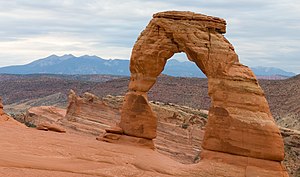
Delicate Arch in Arches National Park, Utah
Coastline. On coasts two different types of arches can form depending on the geology. On discordant coastlines rock types run at 90° to the coast. Wave refraction concentrates the wave energy on the headland, and an arch forms when caves break through the headland. Two examples of this type of arch are London Arch—previously known as dLondon Bridge—in Victoria, Australia, and Neill Island in the Andaman Islands, India. When these arches eventually collapse, they form stacks and stumps. On concordant coastlines rock types run parallel to the coastline, with weak rock such as shale protected by stronger rock such as limestone. The wave action along concordant coastlines breaks through the strong rock and then erodes the weak rock very quickly. Good examples of this type of arch are the Durdle Door and Stair Hole near Lulworth Cove on Dorset’s Jurassic Coast in south England. When Stair Hole eventually collapses it will form a cove.
Weather-Eroded Arches
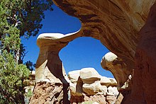
Metate Arch, Devils Garden, a very thin arch near the end of its life
Weather-eroded arches begin their formation as deep cracks which penetrate into a sandstone layer. Erosion occurring within the cracks wears away exposed rock layers and enlarges the surface cracks isolating narrow sandstone walls which are called fins. Alternating frosts and thawing cause crumbling and flaking of the porous sandstone and eventually cut through some of the fins. The resulting holes become enlarged to arch proportions by rockfalls and weathering. The arches eventually collapse leaving only buttresses that in time will erode.
Many weather-eroded arches are found in Arches National Park, Canyonlands National Park, and Grand Staircase-Escalante National Monument (GSENM), all located in southern Utah, United States.
Some natural bridges may look like arches, but they form in the path of streams that wear away and penetrate the rock. Pothole arches form by chemical weathering as water collects in natural depressions and eventually cuts through to the layer below.
Natural Bridges National Monument in Utah protects the area surrounding three large natural bridges, all of which were formed by streams running through canyons, the largest of which is named Sipapu Bridge with a span of 225 feet (69 m).
Rainbow Bridge was also formed by flowing water which created the largest known natural bridge in the Western Hemisphere with a span of 234 feet (71 m), based on a laser measurement made in 2007.
Xianren Bridge, also known as Fairy Bridge, in Guangxi, China is currently the world’s largest known natural bridge with a span recorded at 400 feet (120 m) by the Natural Arch and Bridge Society in October 2010, with a precision of ±15 feet (4.6 m).
Cave Erosion
Natural bridges can form from natural limestone caves, where paired sinkholes collapse and a ridge of stone is left standing in between, with the cave passageway connecting from sinkhole to sinkhole.
Like all rock formations, natural bridges are subject to continued erosion, and will eventually collapse and disappear. One example of this was the double-arched Victorian coastal rock formation, London Bridge, which lost an arch after storms increased erosion.
Moon Hill in Yangshuo, Guizhou Province, China, is an example of an arch formed by the remnant of a karst limestone cave.
Arches as Highway or Railway Bridges

Natural Bridge, Virginia
In a few places in the world, natural arches are utilized by humans as transportation bridges with highways or railroads running across them.
In Virginia, US Route 11 traverses Natural Bridge. Two additional natural arch roadways are found in Kentucky. The first, a cave erosion arch made of limestone, is in Carter Caves State Resort Park and has a paved road on top. The second, a weather-eroded sandstone arch with a dirt road on top, is on the edge of Natural Bridge State Park in Kentucky. The latter arch is called White’s Branch Arch (also known as the Narrows) and the road going over it is usually referred to as the Narrows Road.
In Europe, the Romanian village of Ponoarele has a road segment called God’s Bridge that is 30 m (98 ft) long and 13 m (43 ft) wide, passing over a stone arch 22 m (72 ft) high and 9 m (30 ft) thick.
The railroad from Lima, Peru crosses the Rio Yauli on a natural bridge near kilometre 214.2 as it approaches the city of La Oroya.
LONGEST NATURAL ARCHES in the WORLD
All known natural arches with span lengths of 180 ft (54.9 m) or greater are included in the list. * indicates ones I have seen.
Note: An arch in the Purcell mountains of British Columbia has been estimated to be about 80m long making it one of the largest true arches in the world. It is well known locally even though it does not have a name, but has not received much attention until mentioned in a FB post and I notified the Natural Arch & Bridge Society.
It is also in an impossible position on a knife edge ridge at over 8300′ elevation. Access is via a long drive on a 4WD road, a backpack and then a 7-pitch rock climb. Most evidence of the length comes from a climber who belayed someone over the top of the arch – at about the centre of the arch, 40 metres of rope had been let out. It potentially could be the 2nd longest in the world. See my post Hole in the Wall Arch.
| Rank | Image | Name | Location | Span (m) | Span (ft) | Notes |
|---|---|---|---|---|---|---|
| 1 | Xianren Bridge (Fairy Bridge) | China, Guangxi, Buliu River | 121.9 | 400 | Measured by (NABS) in 2010. Accuracy±15 ft (4.57 m). | |
| 2 | Zhijin Natural Bridge | China, Guizhou, Zhijin Cave Scenic Area | 103.6 | 340 | Measured by NABS, 2015. | |
| 3 |  | Jiangzhou Natural Bridge | China, Guangxi, Jiangzhou | 94.5 | 310 | Measured by NABS, 2010. Estimates 280 ft (85.34 m) to 340 ft (103.6 m), so the midpoint is listed, ±36 ft (11.0 m) Jiangzhou ranks between 2nd and 6th |
| 4 | Dachuandong Arch | China, Guizhou, Si Lian | 91.4 | 300 | Measured by NABS, 2015. | |
| *5 |  | Landscape Arch | United States, Utah, Arches National Park | 88.4 | 290 | Measured by NABS, 2004. |
| *6 |  | Kolob Arch | United States, Utah, Zion National Park | 87.5 | 287 | Measured by NABS, 2006. Formerly considered longer than Landscape Arch. |
| 7 | Qingxudong Arch | China, Guizhou, Dafang | 76.5 | 251 | Measured by NABS, 2015. | |
| 8 |  | Aloba Arch | Chad, Ennedi-Ouest Region, Ennedi Plateau | 76.2 | 250 | Rank based on estimates. |
| *9 |  | Morning Glory Arch | United States, Utah, Grandstaff Canyon | 74.1 | 243 | Measured by NABS. Is a natural arch, not a natural bridge. |
| 10 | Gaotun Natural Bridge | China, Guizhou, Gaotun | 73.2 | 240 | Measured by NABS, 2010. | |
| *11 |  | Rainbow Bridge | United States, Utah, Glen Canyon National Recreation Area | 71.3 | 234 | Measured by NABS, 2007. |
| 12 | Great Arch of Getu | China, Guizhou, Getu Valley National Park | 70.1 | 230 | Measured by NABS, 2013 and 2015. | |
| *13 |  | Sipapu Natural Bridge | United States, Utah, Natural Bridges National Monument | 68.6 | 225 | Measured by NABS, 2007. |
| *14 |  | Stevens Arch | United States, Utah, Canyons of the Escalante | 67.1 | 220 | Rank estimated. Precise measurements not made |
| *15 |  | Shipton’s Arch | China, Xinjiang, K’ashih | 65.2 | 214 | Discovered by Eric Shipton in 1947 and measured in 2000 by a National Geographic Society-sponsored expedition. |
| *16 | Yunmentum Natural Bridge | China, Guizhou, Zunyi | 64.9 | 213 | Measured by NABS, 2013. | |
| 17 | Hazarchishma Natural Bridge | Afghanistan, Bamyan Province, Jawzari Canyon | 64.3 | 211 | Discovered by the Wildlife Conservation Society in 2010. | |
| 18 | Outlaw Arch | United States, Colorado, Dinosaur National Monument | 62.8 | 206 | Discovered by rock climbers in 2006 | |
| 19 |  | Snake Bridge | United States, New Mexico, Sanostee | 62.2 | 204 | Measured by NABS, 1988. On Navajo Nation and not publicly accessible. |
| *20 | 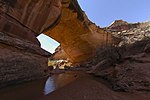 | Kachina Natural Bridge | United States, Utah, Natural Bridges National Monument | 58.2 | 192 | Measured by NABS, 2007. |
| *21 |  | Tianmen Shan | China, Hunan Province, Zhangjiajie | 55 | 180 | 130 m high. Span reported by NABS. |
| *22 |  | Wrather Arch | United States, Arizona Wrather Canyon, Paria Canyon. | 54.9 | 180 | NABS span is not >180 ft (54.9 m). An earlier non-NABS estimate was 246 ft (75.0 m). |
