
Castlegar (pop 9,023 2016) is the second-largest community in the West Kootenays. It is located at the confluence of the Kootenay and Columbia Rivers. Castlegar is a regional trade and transportation centre, with a local economy fuelled by forestry, mining and tourism.
Castlegar was recently cited as one of the Top 8 Places in British Columbia for most promising growth. It is home to Selkirk College, a regional airport, a pulp mill, and several sawmills. The population of 7,259 people includes many Doukhobors, who were largely responsible for much of Castlegar’s early development and growth.
The area that was to become Castlegar was an important centre for the Sinixt (Lakes) Peoples. Outside the city limits are the small surrounding communities of Ootischenia, Brilliant, Robson, Robson West, Raspberry, Tarrys, Thrums, Glade, Shoreacres, Fairview, Genelle, Pass Creek and Krestova. There are also the much smaller communities of Deer Park, Renata, and Syringa on Lower Arrow Lake.
Taken together, these outlying areas comprise an approximate population of a further 8,000 people.
HISTORY
Indigenous People. Castlegar is located in the border area between the Sinixt (Interior Salish) and the Ktunaxa Indian bands. Experts cannot agree where the Ktunaxa range ended, and where the Sinixt began. There was much overlapping of cultural and territorial activity between the two peoples. Most recent information suggests that the Sinixt were the original people in the area and that the Kootenai arrived several hundred years ago from central Canada.
“Qepitles” was a site on the north side of the Kootenay River, just above the junction with the Columbia River. Native implements (arrowheads, pestles, etc.) have been found along the nearby Arrow Lakes. A reconstructed kekuli dwelling was formally located on Zuckerberg Island, at the confluence of the Kootenay and Columbia rivers.
David Thompson. On 5 September 1811, David Thompson arrived at the location where Castlegar now sits, where he camped near the mouth of the Kootenay River. A plaque dedicated to David Thompson can be found on the east bank of the Columbia River overlooking the present-day site of Castlegar.
Transportation Crossroads. Today Castlegar is a busy crossroads with the regional airport and highways that connect it to the Boundary country, the East Kootenay and south to the USA.
In the pioneer era, it was the Columbia River that widened to form the Arrow Lakes that brought settlers. The first came by bateau and rowboat. Then sternwheelers plied the waters for 206 km north to Arrowhead on Upper Arrow Lakes where connection was made with the main line of the CPR.
Sproat’s Landing. This was a sternwheeler landing place on Lower Arrow Lake close to the mouth of the Kootenay River and above a farm owned by the first settler, Thomas Sproat. By the late 1880s, several businessmen arrived at Sproat’s Landing: R E Lemon rafted a load of goods from Revelstoke and opened a store, Bob and Sam Green sold supplies from a tent, and there was a drug store, stopping place and stables operated by the Wilson brothers. The original Sproat’s Landing didn’t last long and today even its location is unknown.
Robson. When the Columbia & Western Railway was built between Nelson and here by the CPR in 1890-91 to provide a link between Kootenay and Arrow Lakes, a new site called Robson with a hotel and general stores was built near the turntable. At first, a ferry transported passengers and goods across the Columbia to connect with the Columbia & Western, but in 1902 a bridge was completed to provide direct access to Castlegar.
Sternwheelers. These served the residents of Arrow-Kootenay Lakes for almost a century. Virtually every community was dependent on them with life governed by the schedule of the flat-bottomed vessels.
The first on the Arrow Lakes was the Forty-Nine, launched at Fort Colville on the Columbia in 1865 in response to a gold rush near the Big Bend where the Columbia River loops around the Selkirk Mountains. Captain L White supplied the thousands of miners with desperately needed food. But Lower Arrow Lake had frozen. He left again in April 1866 fighting upstream for 420kms. The gold rush quickly became known as the “Big Bilk” and the rush ended. On its third trip, the Forty-Nine carried only 3 passengers.
It was 20 years before another sternwheeler, the Kootenai, was launched at Little Dalles, Washington in 1885. She hauled supplies as far as Revelstoke for the construction of the Canadian Pacific Railway. When the railway was completed her service ended.
In 1888, the Dispatch arrived. But instead of the traditional flat bottom, she was a catamaran, but the effect was like having 2 canoes lashed together. She also didn’t have enough room for both wood and cargo – to make time, she had to have lots of wood and little cargo and had to stop frequently to wood up. An August round trip from Revelstoke to Sproat’s Landing took only 4 days.
The Columbia & Kootenay Steam Navigation Company was formed and the Lytton, a $38,000 sternwheeler was built in Revelstoke of the best material by the most experienced ship carpenters from Victoria. She left Revelstoke on July 2, 1890.
By 1890, rich ore discoveries had been made in the West Kootenay and a boom started. That year, Rossland and Trail were born along with a series of communities that included Ainsworth, Kaslo, Sandon, Slocan, Nelson, New Denver, Trout Lake City and many others. Business was so good that the C.K.S.N. bought the Kootenai for $10,000 and paid for her in four trips.
To keep pace, the CKSN built the Columbia for $75,000 at Northport. With room for 40 passengers, she left for Revelstoke on August 22, 1891.
There was intense railway rivalry between the CPR and the US-owned Great Northern. In 1893, the CPR built a 43km spur from Revelstoke to Arrowhead to bypass a rapid-strewn section of the Columbia River. By October, no fewer than six steamers – the Columbia, Lytton, Illecillewaet, Kootenai, Marion and Arrow – and three large scows were using the lake.
In December, the Kootenai struck a rock but the Trail replaced her in May 1896. The Rossland was also built in 1896. She could make the 412km return trip from Arrowhead to Robson in a day. The Minto was added in 1898. She was prefabricated in Ontario and shipped west in 1000 pieces. Her composite wood and steel hull was excellent with shallow water to ice.
In 1902, some Revelstoke businessmen built the Revelstoke to ply the dangerous waters of the Columbia River upstream to Death Rapids. She was a powerful vessel designed for white water, and when unloaded, could sail in water less than knee deep. She plied the treacherous river for 13 seasons before being destroyed in the fire that also wiped out the community of Comaplix.
In 1911, the CPR built the Bonnington, the largest and most magnificent sternwheeler north of San Francisco for an unheard-of $160,000. The four-deck vessel was part of the CPR plan to develop the West Kootenay into a major tourist region.
WWI disrupted plans. In 1915, the CPR completed a railway via the Okanagan to link to Vancouver. The sternwheelers entered their twilight years. Service on Arrow Lake was reduced to three times a week and gradually the magnificent vessels disappeared – the Bonnington in 1930 left only the Minto running between Arrowhead and Robson twice per week.
Life on Arrow Lakes was geared to the arrival of the Minto. Logging camps, postal services and everyone in between was served by the sternwheeler. Finally, in April 1954, after nearly 60 years and some 2.5 million miles of service, she set sail from Robson on her last trip with Captain RS Manning who had joined her in 1911. The family ports of call were all visited – Syringa Creek, Deer Park, Renata, Broadwater, Edgewood, Fauquier, Needles, Burton, Carroll’s Landing, Graham’s Landing, Arrow Park and others.
The CPR sold the Minto to Nakusp for $1 but the residents lost interest. In 1956, a Nelson junk firm bought her for $750 and stripped furnishings, boilers, engines and paddlewheel, everything but the hull. John Nelson from Galena Bay had the remnants towed to his farm but the restoration was too expensive. In 1968, her final resting place was under 40 feet of water, like most everything else on Lower Arrow Lake after the Columbia River Project was built.
Waterloo. Waterloo, a landing on the east side of the Columbia River 32kms upstream from Trail, owed its existence to the mines at Rossland and the smelter some 5kms below Rossland at Trail that blew in its first gold-copper furnace in February 1896. Timber for fuel and construction of the smelter were obtained at Waterloo.
One of those supplying logs was Hiram Landis who came from the US in August 1895. While cutting trees, Landis accidentally found iron capping in the hills and he staked a claim. By the following spring, prospectors were striking ore on Ironclad Mountain and the north fork of Champion Creek. An English syndicate, Lillooet, Fraser & Company, erected several buildings and a mill and a town appeared that they called Monte Carlo. Restaurants in tents, the log Waterloo Hotel and James Hunnex’s general store were the main businesses. A second townsite called Montgomery was surveyed .8km upstream. Land was cleared, streets graded and construction rapidly changed the community and the name was changed to Waterloo. By 1895 there were forty houses in Waterloo. However, the mineral claims were disappointing and by the end of 1898, the post office closed. Waterloo and Montgomery were both deserted.
Hiram Landis never lost hope and kept working on his prospects. He purchased 800 acres from the CPR and another 600 acres for his ranch centred around all the deserted buildings. He was best known as the mayor of Montgomery.
Railway History – The Columbia and Western Railway
Rossland/Trail to Castlegar. Constructed in 1896 by Augustus Heinze, its route connected silver and gold mines at Red Mountain and Rossland and a smelter at Trail. Heinz worked quickly to gain a competitive advantage before the construction of the Canadian Pacific Railway into the Kootenay region.
Initially, it was a 3 ft (914 mm) narrow gauge line, and the steep, 3,400-foot (1,036 m) rise up the mountain from the Columbia River necessitated the use of three Shay locomotives to move the open ore cars, past the fruit trees of Warfield, and onto the LeRoi and War Eagle mines. A spur ran to the Arrow Lakes steamer landing at Robson. Heinze was sold to the Canadian Pacific Railway in 1898. The line was regauged to 4′ 81⁄2 ” (1,435 mm) standard gauge by the CPR in 1899.
Nelson to Castlegar. Railroad construction on the Boundary Subdivision began in 1890 when the Canadian Pacific Railway (CPR) chartered the Columbia and Kootenay Railway and Navigation Company (C&K). The C&K started building from Sproats Landing (across the Columbia River from present-day Castlegar) and was the first segment of what became the Southern mainline. Completion of this line provided transportation of ore from Nelson north on paddle wheelers over the Arrow Lakes and Columbia River to the CPR mainline at Revelstoke. A short extension of the C&K from Sproats Landing to Robson allowed for the construction of a rail barge slip. Robson became the terminus of the active C&K railway. Barges at first joined the C&K and C&W railways between Robson and West Robson.
The Bridge across the Columbia River was completed in 1902 completing the last link in a continuous rail line between Nelson and Midway. This line was renamed the Boundary Subdivision in 1910. Grade revisions were made in the early 1940s and late 1960s to accommodate the construction of the dams at Brilliant and Labarthe (Hugh L Keenleyside Dam).
After the CPR had a standard gauge portage railway running from Nelson to Robson in 1891, they then embarked on a massive expansion placing a line over the Crowsnest Pass to Creston, which indirectly connected to Nelson, then to the portage railway down the Kootenay River. The fundamental basis for all of this was to move coal from Fernie to the smelter at Trail—in connection with shifting the ore down Red Mountain and sending the final reduced concentrates out to the Eastern US. The purchase of the C and W line allowed for the continued westward expansion of a standard gauge line. This it did by 1900 running a link via Brooklyn, Gladstone and Paulson to Grand Forks.
A wooden railway bridge, crossing the large Columbia River, was built in 1902 at Robson to the new town of Castlegar on the west bank. Thus, by this time the Kettle Valley Railway and the Columbia and Western Railway were physically joined to the main Canadian Pacific system via Princeton, Brookmere, Merritt and Spences Bridge. The Coquihalla Pass line to Hope was finished in 1916. Again, the Canadian Pacific had extensive fleets of lake steamers and tugs on Okanagan, Arrow, Slocan and Kootenay Lakes.
Castlegar to Midway. In 1890 gold and copper were discovered near Rossland. The Columbia and Western Railway (C&W) was charted to run from the smelter in Trail to Penticton. This line was completed to Robson West in 1897. The C&W from Rossland to Trail was a narrow gauge railway to the smelter at Trail. On April 2, 1898, surveyors led by a man named Rice reached Grand Forks with slashing crews following close behind them. By September 24, six railroad construction camps between Cascade and Grand Forks employed 250 men. A portable sawmill, operated by McPherson and Stout, supplied rail ties and timbers and W.H. Fisher supplied 70,000 rail ties from a site north of Niagara. The Columbia and Western Railway was purchased from mining developer Fritz Heinze, along with the trail smelter by CPR in 1898.
The Boundary country ore (from the City of Paris Mine) was delivered to the Trail smelter. On November 25, 1899 passenger service was extended to Greenwood. By 1900 the railroad had reached Midway with a branch line from Eholt to the copper-rich area of Phoenix. Construction of this railroad required great effort and was often times extremely dangerous. On January 11, 1900, two men were killed by flying rock. On February 4, 1900, 100 men were sent out two shovel drifts. By reaching the Boundary District, the CPR had scored a major victory against its American railroad competitors in its bid to re-establish Canadian control in southern British Columbia. American communities along the Kettle River and tributary valleys south of the international boundary found it easier to ship via CPR than to use the long and rough wagon roads leading to J.J. Hill’s Great Northern (GN) railroad in Washington State.
CASTLEGAR. The first settlement in what is now Castlegar was West Waterloo, now known as South Castlegar. Castlegar takes its name from Castlegar, County Galway in Ireland, the ancestral home of townsite founder Edward Mahon. The city was planned in 1897.
In the spring of 1898, the CPR started to build the extension of their Columbia & Western Railway from Robson to Midway, some 161kms to the west in the mineral-rich Boundary Country. The construction company of Mann, Larsen and Foley established their headquarters 48kms up Arrow Lakes at Brooklyn.
Around 1902, the Canadian Pacific Railway (CPR) built the bridge at Castlegar and laid the wide gauge railway tracks to Trail. They put in a box car station at the old Waterloo trail crossing and called it Kinnaird Station in honour of Lord Kinnaird who was a shareholder in the CPR.
There was little in Castlegar until after the completion of the CPR bridge. Mr. Farmer built the first store in town, housing both the post office and the town hall. William Gage built the Castlegar Hotel in 1908, standing until 1982 when it was destroyed by fire. Also in 1908, the first schoolhouse was built by a few local residents who bought the lumber and erected the building. A dance pavilion, garage, tourist cabins and a slaughterhouse had all been established by 1925.
On 30 October 1946, Castlegar was incorporated into a village, then in 1966 into a town. It amalgamated with the neighbouring town of Kinnaird into a city on 1 January 1974, effectively doubling the population. On 20 May 2004, the City’s boundary was extended to include the Blueberry Creek Irrigation District.
The population in 2016 was 9,023.
The Doukhobors. In 1908, the Doukhobors established villages on a flat they called Ooteshenie. They purchased land – 2,700 acres at Waterloo (including Hiram Landis’ ranch) and 3,000 acres up Pass Creek Valley. The Doukhobors sent 80 men to prepare the place and they took up residence in the vacant buildings of Waterloo. They cleared the land, planted fruit trees, laid out an elaborate irrigation system of wood-stave pipe and installed a drift ferry across the river to a place called West Waterloo. This became Kinnaird and today is South Castlegar.
The Doukhobors were successful and by 1912, 6,000 had established communal villages throughout the surrounding area. Today most still survive and share Ooteshenie Flat with the Castlegar Regional Airport and Selkirk College. The old gold towns of Waterloo, Montgomery and Waterloo Landing have vanished.
The Doukhobors put a ferry into operation near Brilliant on the Kootenay River in 1910 and the Christian Community of Universal Brotherhood (CCUB) made an application to the CPR for a railway station and siding to this point. Brilliant was the centre of the CCUB commercial enterprises. Located on the site were the Brilliant Jam Factory, a grain elevator, and a flax seed mill.
For an extensive history of the Doukhobors in Russia, Ukraine, Georgia and Canada, see History of the Doukhobors (a local history) and The Doukhobors (Wikipedia).
Climate. Castlegar has a humid continental climate or an inland oceanic climate, bordering an inland warm-summer Mediterranean climate. Summers are warm and sunny, with late summer being quite dry, while winters are cool and frequently unsettled. Precipitation peaks in the winter months when the Aleutian Low is strongest, and a range of precipitation is experienced, sometimes in short periods. Castlegar is wetter than most places in the Southern Interior of BC, and the city receives around 400 mm more precipitation than nearby Kelowna, Penticton and Kamloops (which are in the drier Okanagan region of British Columbia, while Castlegar is in the Kootenay region).
The highest temperature ever recorded in Castlegar was 41.1 °C (106 °F) on 2 July 1924 and 11 July 1926. The coldest temperature ever recorded was −30.6 °C (−23 °F) on 30 December 1968.
Airport. The West Kootenay Regional Airport is owned and operated by the City of Castlegar. The Airport has regular service to both Vancouver International Airport and Calgary International Airport. Nearby airports include Trail Airport, which is 40 km (25 mi) to the south.
Education. There are four elementary schools and one high school, Stanley Humphries Secondary School. Selkirk College’s main campus is also located in Castlegar.
Recreation. There are dozens of great walking trails maintained by the Castlegar Parks and Trails Society. The Columbia River cuts through Castlegar, and to the west along the river are Scotties Marina and Syringa Provincial Park, with boating and camping amenities. The Castlegar Golf Course is a top public course set high above Ootoshenia.
Geography. The main street, Columbia Avenue, runs the length of the city. It becomes Highway 22 on the South end, and the Robson Bridge at the North end. Most businesses in Castlegar are located on or just off of Columbia. There are several neighbourhoods in Castlegar, including Downtown, Southridge, Oglow Subdivision, Woodland Park, Grosvenor, Kinnaird, and Blueberry Creek, among others. Outskirts of Castlegar include Robson, Robson West, Brilliant, Raspberry, Pass Creek, Ootischenia, Tarrys, Thrums, and Genelle.
Transportation. Today, Castlegar is considered to be a transportation hub for the region – a busy crossroads with the regional airport and highways 3A, 3, and 22 that connect it to the Boundary country, the East Kootenay and south to the USA. The West Kootenay Regional Airport (YCG) is the main local airport in the region with flights to both Vancouver and Calgary.
Highway 22 runs the length of the city, known as Columbia Avenue and to the South, Highway 22 leads to Trail. At the North End, Columbia enters the Robson Bridge, carrying traffic to the rural suburb of Robson, which is accessed via Broadwater Road.
Highway 3 bisects the town, crossing the Columbia River at the Kinnaird Bridge to Ootischenia and leading to Salmo. From the West to Grand Forks,
To the North, Highway 3A heads to Nelson., British Columbia.
Economy. The largest employers are the pulp mill, Selkirk College, the regional airport and Cominco in Trail.
Other attractions are the Castlegar Sculpture Walk, Millennium Park, and Zuckerburg Island.

North Castlegar with Robson in the foreground
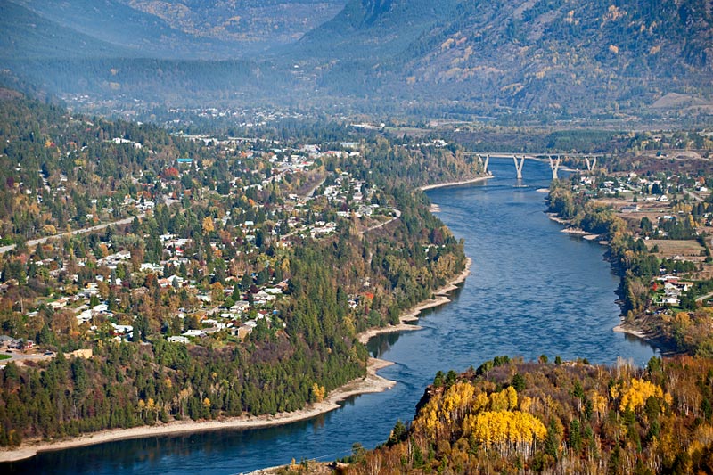
View from the south looking north with the Kinnaird Bridge crossing the Columbia River
I was a family physician working in Castlegar for 30 years from 1977 to 2006. After about 1997, I lived in several West Kootenay communities – along Arrow Lakes, Rossland, Warfield and New Denver. I return most summers to see friends, hike and golf. I am a life member of the Castlegar Golf Course, one of the best public golf courses in Canada. I try to attend the Kootenay Mountaineering Club hiking camp held every summer throughout the Columbia and Rocky Mountains.
INFORMATION
trailsintime.org – Walter Volovsek’s excellent website detailing the history of the Castlegar area.
friendsoftrails.org – The best website on Castlegar’s trails
