
NOOTKA TRAIL
Note that because of COVID-19, and for the entire 2020 season, there is no access to reserve land at Friendly Cove. Neither the Uchuck nor any water taxis are sailing and the only access to the trail is by plane. Because they cannot land at Friendly Cove, they are using a small fresh water lake about 1km from the village. They can’t take off with a full load so only land here with a full load and take off empty. As a result in 2020, the trail can only be done from south to north ending at Louie Bay.
This rugged, remote 22.4mile (35km) point-to-point trail follows the coastline of Nootka Island, Vancouver Island’s largest offshore island. There are views of ocean with spectacular surf breaks, beaches and tidal shelves, frequent sea otter and whale sightings, black bears, wolves and bald eagles in old-growth forests. Still, the Nootka Trail is almost empty.
Kayaking the outside of Nootka Island is a great adventure but the water is wild and risks potentially high. Safe havens are few and far between along this long stretch of open coast.
The traditional territory of the Nuu-chah-nulth First Nation incorporates much of the western portion of Vancouver Island, having been inhabited by the Nuu-chah-nulth people for thousands of years. The village of Yuquot is at least 4,300 years old. Friendly Cove juts into Nootka Sound.
There is a trail fee of $45 per person payable to the Mowachaht/Muchalaht First Nations Band to provide access to their facilities at Friendly Cove and the traverse of their three reserve sites on Nootka Island. Pay at an office on the far end of the church.
By comparison with the West Coast Trail, the Nootka Island Trail is not patrolled, poorly marked and infrequently maintained. It does not even officially exist. Be prepared to bushwhack around fallen trees brought down by the frequent, savage winter storms that pound this section of coast. In order to avoid an exhausting amount of bushwhacking, consult tide charts for the most opportune times to cross beaches – sometimes on sand, but mostly pebbles, cobble or even rocks. Some rivers must be forded, which must be done at low tide if crossing at or near the ocean, as with rounding headlands. Be aware of the potential for rogue waves when on the rocks.
Most people hike it from north to south, starting at Louie Bay and ending at Friendly Cove. The hiking is generally along the ocean on everything from rock shelves to white sand to boulders. It often leads inland to bypass rocky headlands and deep river mouths. Buoys and metal tags on trees mark the trail avoiding the many wildlife paths.
Tide tables are indispensable to hike the most beach and have a much more pleasant experience. Walking the tide shelves are great rather than the larger rocks. Tables also help you avoid high water trapping short of a campsite.
Tides are diurnal but the two daily lows may vary by 5 feet or more and you may need the lower tide to pass a headland. The time of high and low water advances about 50 minutes each day.
Campsites on the Nootka Island Trail are located at Third Beach, Skuna Bay, Calvin Falls, and Beano Creek. Some campsites are harder to find and may require a little exploration from the beach. There are sheltered campsites in the trees or brighter, airier campsites with fewer bugs on the sandy shore.
History. In March 1778, about 1,500 natives of the Nuu-chah-nulth (Nootka) confederacy of 13 First Nations were living in a summer village with wooden longhouses at Yuquot on the west side of what is now called Vancouver Island. Led by Chief Maquinna, they were hunter-gatherers, who lived from the bounty of the ocean, particularly salmon and halibut, as well as sea mammals and shellfish. They also hunted and gathered plant foods.
First Encounter. Can you imagine their surprise when two sailing ships, the Resolution and Discovery with enormous white sails and manned by people with pale skins, entered the cove. This was a momentous historic event, the first encounter of northwest-coast indigenous people with white men.
Considered savage for their lack of technology, lack of written language and hunter-gatherer life style, they had great depth to their culture, traditions, artwork, fishing and whaling skills. Perhaps most telling was their hospitality. This was the site of the historic meeting between Captain James Cook and the Nuu-chah-nulth First Nations people on March 29 1778. Yuquot was once home to as many as 17 longhouses.
Cook had pulled in to make repairs and must have been pleased that the indigenous people were friendly. Cook’s welcome here earned the name ‘Friendly Cove’. For a month the two parties engaged in trade with the natives providing sea otter pelts and the visitors supplying knives, chisels, nails, buttons and metal goods. Yuquot, which means “where winds blow from many directions”, was later renamed Friendly Cove due to the welcoming nature of the natives. (Today, the Mowachaht/Muchakaht First Nation, whose land it is, is reviving the name Yuquot.)

A stained glass window in the Yuquot Cultural Centre.
This encounter led to a frenzy of activity with numerous ships coming from Europe to trade for the coveted sea-otter pelts. Already living in a bountiful region, the local tribes now also received valuable trade goods. For the next few decades, the 13 Nootka tribes were the wealthiest in Canada, and Yuquot became known as the Centre of the World for the tribes of Vancouver Island.
Chief Maquinna, the leader of the Nuu-chah-nulth people during this fur-trade heyday, was a shrewd negotiator in trade, and played an important diplomatic role in completely different historical event. Maquinna was an honorary name for all Mowachaht chiefs – records don’t distinguish who had the name at the time as his actual name was never recorded.
The late 1700s and early 1800s were the glory years for the peoples of this area. However, traumatic times lurked around the corner. First, the hunger for furs petered out and the last sea otter trading vessel departed the area in 1825. Then European diseases (malaria and smallpox) struck and, combined with cultural turmoil resulting from contact with westerners, by 1830 more than 90 per cent of the Nuu-chah-nulth had died. The federal Indian Act and residential schools followed, leading to a long period of effectively being second-class citizens in their own country.
The Spanish were trying to claim this territory and tensions between them and the British flared. As a chief, Maquinna became a famed ambassador by hosting both Vancouver and Spanish envoy Juan Francisco de la Bodega y Quadra for talks at Yaquot, the outcome eliminating the risk of war between Britain and Spain in 1790. Chief Maquinna helped resolve the situation peacefully. He is still revered today.
Fort San Miguel, the only Spanish fort built in North America was built in Yaquot. Maquinna’s brother was killed in 1791 by the Spanish. This and other unrecorded transgressions created tensions that spilled over when Maquina led a slaughter aboard the ship the Boston in 1803. One man from that ship survived three years of enslavement and John R Jewitt’s resulting book offers perhaps the most comprehensive look at the Nun-chah-nulth culture prior to European dominance.

![]()

Getting there. The trip to Nootka Island is part of the adventure. It can only be reached by boat or floatplane. It’s located about 40 kilometres by boat or plane from the nearest town of Gold River, a former logging village.
Access to Louie Bay or the Friendly Cove Trailhead is by floatplane from Gold River, Tahsis, Campbell River or Tofino, or by the sea on the MV Uchuck 111, a minesweeper turned supply ship, from Gold River (Muchalat Inlet) to Yuquot (Friendly Cove).
To get to Gold River, first fly to either Campbell River (with service from Vancouver) or Comox (with flights from Calgary and Edmonton). Rent a car as there is no public transport to Gold River, and then drive 90 kilometres west of Campbell River on Highway 28. From Gold River either fly in a floatplane with Air Nootka (from $435; 250-283-2255 airnootka.com) or use a water taxi.
Hikers can also reach both trailheads by water taxi from Gold River (Maxi’s Water Taxi, (250) 283-2282, ssavey@yuquot.ca) or Tahsis (Tahtsa Dive Charters) or Zeballos (Zeballos Expeditions) to Yuquot in the south or Louie Lagoon or Ferrier Point in the north. Since water taxis can’t pass the shallow lagoon entrance, the arrival requires a low-tide hike along the shore of Louie Bay then a climb over the rocky shore to Third Beach.
The local band also provides a water taxi from Gold River to the trail and from Friendly Cove to Gold River. They have not advertised this option but the cost is only $50 per person. Contact the band for more information.
It is important to coordinate the start with the end and the departure via the Uchuck III.
From Friendly Cove, return by water taxi, floatplane or the M.V. Uchuck III that stops in Friendly Cove on Wednesday and Saturday afternoons during the summer only (reservations required; Nootka Sound Service 250-283-2325 mvuchuck.com).
Air Nootka (Gold River) *all taxes and fees included
Flight Sharing. Go to the Air Nootka Facebook Page/flight sharing to find others willing to share flights if they have empty spots.
Depart Gold River to Louie Lagoon –
Cessna (3 passengers): $661.50 CAD
Beaver (6 passengers): $897.75 CAD
Return from Friendly Cove to Gold River –
Cessna: $367.50 CAD
Beaver: $498.75 CAD
DAY 1 Flight, Louis Bay to Third Beach. Hike to Tongue Point or Northwest Cone
The float plane lands in Louie Bay Lagoon (49.724004, -126.932371) (also called Starfish Bay). Change into your water shoes before wading to shore.
Pick up the trail (49.723765, -126.932355) at the southern end of the lagoon and head south to Third Beach. Look for surveyor’s tape (plastic ribbon) that flags the best route for hikers. Unflagged trails are usually black bear trails. The 1km hike from the lagoon to Third Beach is surprisingly difficult due to a huge blowdown (and too-heavy packs). It is the hardest part of the entire hike. But once you are at Third Beach, you are in paradise, an expansive sandy beach with camping and water.
Campsite 1. Third Beach (also called First Beach 49.718022, -126.936947) and most people’s first camp site. If you plan to spend the night here, camp above the driftwood and nearby tide pools. Tip: The fixed ropes in the trees can be used to hang bear bags.
What to do? You can day hike 1 hour north along the mudflats to a salt-water narrows at Louie Bay’s south end. It is passable only at tides of 1.8m or less. Head north along the mudflats another 1 hour to Tongue Point. Find the remains of a hull from a wrecked ship, moved here as part of an unsuccessful salvage operation. The Greek ship Tries Ierarchi smashed into the rocks in late 1969, southeast of Ferrer Point. With time and tides, follow an overgrown road from Tongue Point 1 hour to Northwest Cone with the ruins of an early radar installation.
DAY 2 Third Beach to Calvin Falls 4-5 hours
Starting south the trail cuts inland to avoid a tricky headland about 1km to the southeast. Floats and buoys mark the bypass route start. The beach route is passable only on an extreme low tide. South of the headland, hike along the tidal shelf to Skuna Bay (good camping and water). If you plan to hike with low tide make sure you have low tide first thing in the morning as it makes the hike very easy all the way to Beano Beach.
To bypass the headlands that border the beach, leave the beach and tackle the steep, sometimes muddy climb that leads to a forest trail (trail entrance is marked with buoys).
The route leaves the forest and traces the beach toward Skuna Bay.
Skuna Bay (49.671766, -126.867843). This narrow strip of beach is not nearly as good of a campsite as Calvin Falls, and there may not be water here during dry summers. However, if there are other hikers on the Nootka Trail, chances are Skuna Bay will offer more privacy.
Another tricky beach passage is just before Calvin Creek that drains Crawfish and Ewart Lakes.
Campsite 2. Calvin Falls (49.657572, -126.841418). The falls are a welcome respite after a hot day.
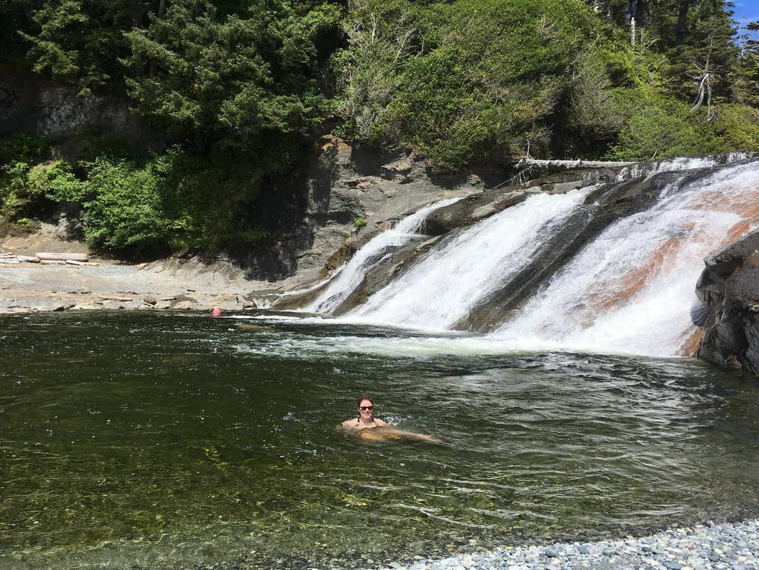
Make sure you spend a night camped here at Bajo Beach where Calvin Creek cascades 20 feet onto the sand in a picture-postcard waterfall. The sandy pool at the base of the falls is great for a swim. There is ample space for tents to spread out along the huge mile-long beach. The campsite right beside the falls is pretty unique if you can sleep with the noise.
Surf huts are hidden in the woods nearby. There is also good protected camping with a shelter on the north side of the falls if it’s really rainy. Cross the creek below the waterfall (wait until low tide).
Look for whales, orca, and sea otters resting and hunting among the kelp.
DAY 3 Calvin Falls to Beano Creek 3-4 hours.
The beach is the usual route form Calvin Falls to Beano Creek. First cross Bajo Creek, an unreliable water source due to its brackish nature. The packed sand beaches transition to rocky shoreline. Watch your balance as you maneuver across rocks of all shapes and sizes.
Bajo Point. A large offshore sea stack marks Bajo Point. When the tide is low, hikers can walk to Bajo reef. This is a First Nations Reserve. From here, the route winds across the tidal shelf and crosses pebble beaches.
Optional: A tiny trail leads inland to the site of an abandoned Mowachaht fishing village of Aass (E’as) in a stand of huge Sitka Spruce (located in the Aass Indian Reserve). Three depressions mark the location of the historic houses. do not disturb anything at this site.
By the mid-1800s, the indigenous otters had been depleted by early fur trading, mainly Russian. The sea otter was successfully reintroduced to the area 60 years ago.
It’s slow going along the pebble beaches.
Campsite 3. Beano Creek. Wait until low tide to cross Beano Creek (caution: winter storms can change the shape of the drainage). Beano Creek has camping and water. The ancient whaling village of Tsarksis was located nearby. If you’re planning to spend the night, head to the south side of the beach; a few private cabins are located here as well. Beano Creek is the only spot where you’re likely to see other humans – the surf break here has attracted cottagers.
Fill your water bottles here as this is the last reliable water source until a small beach near Yuquot. To refill water bottles, search for fresh pools of water as it is hard to travel far up Beano creek for water due to a steep shoreline. Given the tide flow upstream you want to collect water at lower tide if possible.
Next: Wait for a low to intermediate tide to continue along the beach. A spring is located roughly a mile south on the beach.
DAY 4
The trail gets more rugged as you continue south, with cliffs and headlands forcing the route overland. The trickiest stretch of hiking begins an hour east of Beano Creek. At the first of many impassable headlands, take the first (somewhat brushy) or second (fixed rope; marked by buoys) trail up into the woods. Use caution when hiking on the slippery rocks and moss. Most of the beaches after Beano do not have a reliable water supply and be careful of the tides as the high tide mark can be very high.
Callicum Creek (49.603924, -126.71957). Refill your water reserves if you’re hiking during a dry spell; there may not be any water near the choice cliff-top campsites between here and Maquinna Point. Can camp at Callicum Creek, though the views are wilder and more spectacular further south.
Maquinna Point (49.582501, -126.676837). Leave your pack at the trail junction and follow the side trail to Maquinna Point for spectacular coastal views. Scrambling leads to the best vistas. Watch for sea otters and grey whales along the south end of the trail.
49.59704, -126.702662 is the last of the beach camping options (there’s no dependable water source here). Caution: Make sure to camp above the highest tide level.
After 13 km or so, can stay at a beautiful little pocket beach past Maquinna Point. Even better is the next beach marked “Caves” – one has clearly been used as a tent site before. Take your pick – one pocket beach after another provides an amazing selection of private, memorable locations to pitch your tent. Most have running creeks, though that won’t always be the case at drier points in the summer.
Caves Trail: Take the short side trail to the beach-level caves, which are great shelters for camping during heavy rains (no dependable water source).
The Tsa’tsil water crossing (49.589592, -126.652783) is the last major obstacle en route to Friendly Cove. Cross at low tide to avoid the rising tidewaters that rush upstream into Tsa’tsil (water shoes are recommended) – it can be a formidable current at times. There is good swimming at the narrows where the saltwater river flows in and out of Tsa’tsil Lagoon. The best place to cross is usually about 150 feet from the mouth; prepare for ankle to waist deep water.
Allow at least 8-9 hours hiking time between Beano Creek and the tidal lagoon and many hikers make this a two-day stretch.
You can camp here, best on the southwest side, but there is no water. The next spot for camping and water is a pocket beach to the east.
The trail between the tidal lagoon and Yuquot, part of Yatz-mahs Trails, is maintained by the Mowachaht/Muchalat Band, the Ministry of Forests, and Western Foreest Products.
Other trails lead through old-growth trees to an unnamed lake and Jewitt (Aa-aak-quaksius) Lake. The last 4-5 Km of the trail can be very challenging and takes 1.5 hours. It is suggested not trying to hike out from Beano beach but look for a site 2-3 km further.
Yuquot (Friendly Cove). Yuquot means “the place where the wind blows in all directions.” This picturesque site was once the summer village for the Mowachaht tribe (often called the Nootka, but Mowachaht is their proper name). Yuquot Point is at 49.590758, -126.620862.
The Mowachaht Band members moved in 1968 to the Tsaxana Reserve at Gold River, and consider Yuquot, which was declared a National Historic Site in 1923, a crucial part of their heritage. They recognize the historical significance of this spot and, as part of their economic revival, are working to make it a tourist destination. Visitors are attracted by nature, history and the southern terminus of the Nootka Trail. Take some time to check out the old church and learn about the rich history and see the native carvings.
Chief’s shrine. Passed down through the generations, it contained an assortment of carvings, mummies, skulls, and skeletons, including those of children. Originally hidden on an island in Jewitt Lake, it was taken to the American Museum of Natural History in New York in 1905. Whaler’s shrines were never meant to be seen as they were private places created for ritualistic purification to aid luck in whaling.
Friendly Cove (49.592725, -126.619629). The bay is a sheltered anchorage for paddlers and boaters.The Uchuck docks are under the shadow of the lighthouse, built in 1911, that sits atop a rocky ridge. It was one of the last staffed lighthouses in B.C. No permanent residents live here.
Near the pier once stood the only Spanish fortification in Canada. Fort San Miguel was built with 16 cannons in 1789, only to be abandoned six years later.
On a low ridge a ten-foot-tall carved wooden welcome figure with outstretched arms faced the ocean, inviting visitors to come ashore.

The church was built in 1954 after the original (1889) burned down. Now a Cultural Centre, the inside is alive with large totems and colourful carvings of eagles, wolves and orcas of the native pantheon.
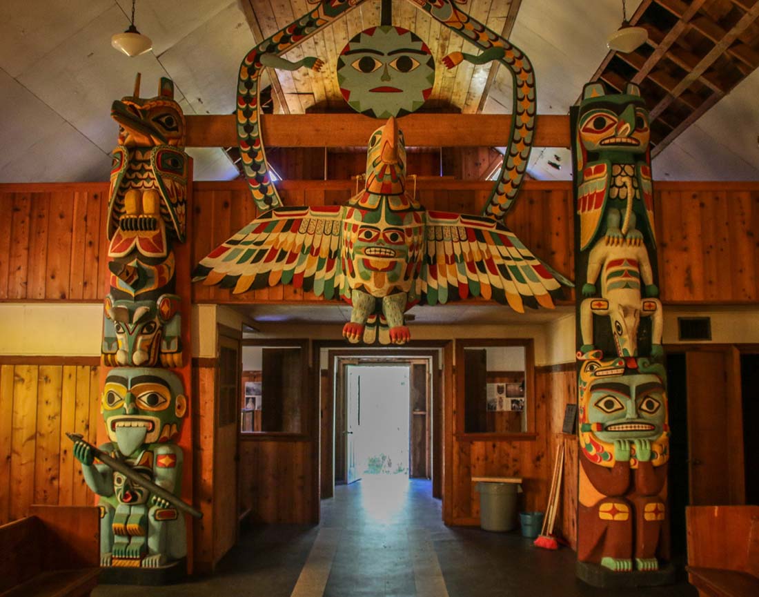 Inside the Yuquot Cultural Centre, a former church.
Totem Pole. (49.590795, -126.619577). The last totem pole in Yuquot once stood at the entrance to a longhouse, or family residence. Raised in 1929, high winds knocked it over in 1994 and it lies abandoned in the shrubbery just above the beach. One of the faces still shows tinges of blue paint. Nearby in a small cemetery old tombstones were sinking under green growth.

The fallen, abandoned totem pole.
Master carver Sanford Williams lives here in the summer months and works in a shed. Today he creates his carvings with handmade tools in the traditional way. Numerous art pieces and photos of totem poles and other creations are in the shed.
The camp ground at Friendly cove has bathrooms and you can get water from the church. Camping at Friendly Cove is in a field and the trail fee covers one night. You can rent one of six small cabins.
On Saturday and Wednesday they BBQ salmon on the beach for the tourists. If you need to contact Air Nootka, Ray Williams, the caretaker and only year-round resident, can place a radio.
This is where Captain Cook first came ashore in B.C. in 1792. It’s also where the British and Spanish almost went to war over the sea otter fur trade. There are two monuments on either side of the lighthouse that require climbing over rocks to reach. One monument is to commemorate Captain Cooks arrival. The other is at the old Spanish Fort site and is difficult to reach.
Santa Gertrudis-Boca Del Infierno Provincial Marine Park is a 440ha protected marine park and old growth forest, north of Friendly Cove. The park can be accessed only by water.
Head to the dock for the ride back to Gold River on the historic Uchuck III which sells freshly baked muffins, sandwiches and chili for astonishingly reasonable prices.
Costs. Costs $50/person to cross Mowachaht tribal land.
Floatplane:
Air Nootka (Gold River) *all taxes and fees included
Depart Gold River to Louie Lagoon –
Cessna (3 passengers): $661.50 CAD
Beaver (6 passengers): $897.75 CAD
Return from Friendly Cove to Gold River –
Cessna (3 passengers): $367.50 CAD
Beaver (6 passengers): $498.75 CAD
Uchuck III: Due to COVID-19, the Uchuck is not docking at Friendly Cove in 2020. Normal cost $57.
Mowachaht/Muchalaht First Nation Band Office, Box 459, gold River V0P 1G0, (250)283-2335, info@yuquot.ca
When to go. The best weather is from May through September. July through September are the most popular times. March to June are typically wet and mild. October and November are starting to get wet and colder. Heavy rains and high surf the rest of the year make the trail very muddy and much harder. May, June and September are particularly quiet.
Start your day’s hiking on a falling tide. Many sections of the beach route are impassable on a flooding or high tide. Some creek and river crossings are only safe at low tide. Watch for irregular, large and dangerous rogue waves, particularly if you are hiking the shelves and around headlands.
Time needed. Five days should be plenty to cover the 35 kilometres, but this is a trail worth savouring. So add an extra day or two.
Experience required. The Nootka Trail is a rugged and remote route that is maintained by volunteers somewhat sporadically. It should not be taken lightly. Hazards include: creek crossings, wildlife, rough terrain, difficult footing and ocean waves. Being able to read tide tables is essential.
The trail traverses a variety of shoreline that includes sandy, pebbled and boulder beaches, slippery, seaweed-covered tidal zones, slick sandstone shelves, irregular peninsulas and rocky ledges. Sections of the inland trail can be extremely muddy. Blowdowns may impede the route. A 15m rope may be required on some headland bypass tracks.
What to take. Be prepared for torrential rain at any time at any time of the year. Bring reliable rain gear (umbrellas are very useful), a good tent and a small tarp to be able to get out or the rain.
Solid hiking boots will save your ankles on rocky beaches. Sandals or water shoes for crossing the numerous creeks and rivers. The route is well-signed, but don’t go without topo maps for the area, in addition to a tide table and charts. Precise tidal knowledge is essential when hiking the Nootka Trail.
Cell phones don’t work here, so you may want to bring a satellite phone, PLB or even a VHF radio (the sole source of help is from the lighthouse staff at Yuquot. The Uchuck III also has radios that could be contacted as they drive by). And some kind of water purification is a good idea.
Resources
Topographical maps. Two cover the trail – 92E/10 Nootka (all but the north tip) and 92E/5 Zeballos (north end).
Coastal Hikes, by Philip Stone, is a concise guidebook to 10 coastal hikes in B.C. and Washington State. It has a small-scale general map, 13 colour photos and is fulled with camping hints, hiking highlights and descriptions fo side routes that a dozen trips along the trail have revealed.
The Nootka Trail: A Backpacker’s Guide, by Pal Horvath, is an authoritative 12-page guide to the trail.
Federation of Mountain Clubs of BC (FMCBC) has a good Nootka trail brochure and map.
Canadian Tide and Current Tables.
Additional reading. White Slave of the Nootka, by John Rogers Jewitt, is a first-person account of how two British fur traders ended up enslaved by the Muchalaht people.
Accommodation
Stay in Gold River the night before hitting the trail at one of the hotels and campgrounds (goldriver.ca). Primitive beach campsites are available at regular intervals on the trail and there are rustic cabins for rent at Friendly Cove (1-800-238-2933). There are no camping fees on the trail but there is a $45 trail fee charged by the Muchalaht Indian band, payable at Friendly Cove (yuquot.ca/nootkatrail.html).
Trail Bests:
Best swimming hole: Just above Calvin Creek Falls at Bajo Beach is the perfect spot to wash away two days of trail grime. This shower is the highlight of the trail.
Best view: The oceanside cliff at Maquinna Point provides a 270-degree vista of rocky coastline, endless Pacific and Vancouver Island’s west coast.
Best artifact: A toppled totem pole that is slowly disappearing back into the rainforest lies next to an old house foundation in Friendly Cove.
Other highlights include swimming and body surfing in the Pacific Ocean, beach combing, and exploring ancient First Nation middens. Note that middens are protected archaeological sites, and disturbing archaeological sites in British Columbia is a criminal offence.
Hazards
Creeks. Cross streams at low tide.
Rogue waves. Can be deadly.
Rising tides in exposed situations.
Bears. There is a large population of black bears on Nootka Island, and the chances are therefore good that hikers will encounter them along the beaches. At present, these bears do not associate hikers with food. Keep all supplies cached well out of reach of these animals. Other wildlife that may be encountered or viewed from the trail include cougars, grey wolves, black-tailed deer, Orca (killer whales), grey whales, California sea lions, harbour seals, sea otters, bald eagles, and shore birds.
Seaweed Beaches (49.603896, -126.718969) Masses of seaweed, washed ashore by the tide, make beach hiking akin to walking on a slippery sponge.
Driftwood requires good balance.
Gaiters help to keep the small stones out of your boots.
Hiking poles very helpful in land and on the rocks / creeks.