
Note: Because of COVID-19, the entire Hesquiat Peninsula is closed, probably for the entire 2020/21 season. The only access is by plane and they are not flying.
This 50 kilometre backpacking hike goes from Escalente Point around the rectangular peninsula ending at Cougar Annie’s homestead and gardens at Boat Basin in Hesquiat Harbour. What sets this hike apart is that almost the entire hike is along the shore, almost exclusively a beach hike with very few significant cliffs or other obstacles.
The geology of the shoreline is remarkable throughout with expansive tidal shale rock shelves, wild sculptured conglomerate and sandstone formations, endless boulder fields and stunning sandy and pebble beaches that run for miles. There is no trail and the terrain is varied and often difficult – like hiking an obstacle course – aim for the path of least resistance between forest and ocean as determined by tides and topography. It is a true wilderness hike with no park infrastructure and one of the least trodden paths along the Vancouver Island coast – it attracts only about 100 hikers annually due to its remote access.
Hesquiat Peninsula Provincial Park. This region is the ancestral home of the Hesquiat First Nation who are part of the west coast Nuu-chah-nulth people. Much of the land on the Hesquiat Peninsula is now Provincial park from Escalante Point all the way around to Hot Springs Cove which is part of Maquinna Marine Park. The provincial park was established in 1995 as 7,888 hectares of coastal temperate rainforest and foreshore ecosystem within Clayoquot Sound Biosphere Reserve. It lies south of Nootka Sound and north of Clayoquot Sound. It includes old growth stands of Sitka spruce, western red cedar and hemlock. Several species at risk including the marbled murrelet, sea otter, grey whale, Stellar sea lion and northern abalone fine refuge here. The park is also home to aboriginal whaling sites, coastline where the first Europeans explored British Columbia and a heritage lighthouse, the only place in Canada attacked by the Japanese in WWII.

Getting There and Away. Floatplanes from Tofino are not only the fastest and most affordable way to reach the park, but the only way as boats don’t seem to run this far.
From Tofino: Atleo River Air Service (atleoair.com). Tofino Air (tofinoair.ca)
From Gold River: Air Nootka (airnootka.com)
Campsites. Escalante Point, Barcester Bay, Homais Cove, Estevan Point, Matlahaw Point, Smokehouse Bay, Hesquiat Village, Le Clair Point, Cougar Annies Garden.
DAY 1 Escalante Point to Barcester Bay – 12.2 kilometre, elevation gain 172 m
The Hesquiat Peninsula Trail begins at Escalante Point, where the float plane lands in thigh deep water to access the white sand beach.
The point features unique rocky features and abundant marine life. Heading south, leave the beach to soon access a vast shelf of exposed sandstone. This is part of the 30 million years old Carmanagh Group. It makes for fast hiking despite the rows of serrated edges.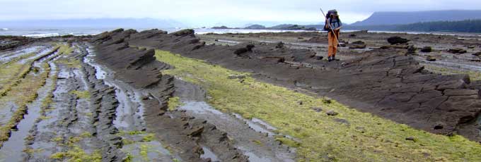
The Gulch. This narrow surge channel requires low tide to cross and uses a rope left by past hikers to scramble uphill through the thick salal.
Split Cape. Reach these rock shelves at lower tide.
Barcester Bay. A long crescent beach with pounding surf. Grey whales are seasonal visitors to this coast line. Camp beside sand dunes near where a stream creates a brackish pond just before entering the ocean.
DAY 2. Barcester Bay to Estevan Point.
Homais Cove. 6.6 kilometres from Barcester Bay, camping here results in a short stage that allows you to take your time and enjoy the views and wildlife along the shore. Homais Cove is another great spot to camp for the night, featuring more interesting rocky outcrops and tide pools.
Perez Rocks. Named after Spanish explorer Lieutenant Commander Juan Perez, the first European to sail these waters aboard the frigate Santiago in 1774, four years before British Captain James Cook. The rocks are a haul-out for 600 Stellar and 900 (all male) California sea lions, with the greatest numbers seen in the fall. Elephant seals have also been seen here.
“Wastelands”. The most arduous part of the trip – a vast shelf of boulders that take 1½ days to cross. Hopscotch from one slippery mound to the next. Other obstacles include lumpy marsh and massive piles of driftwood to avoid the rising tide.
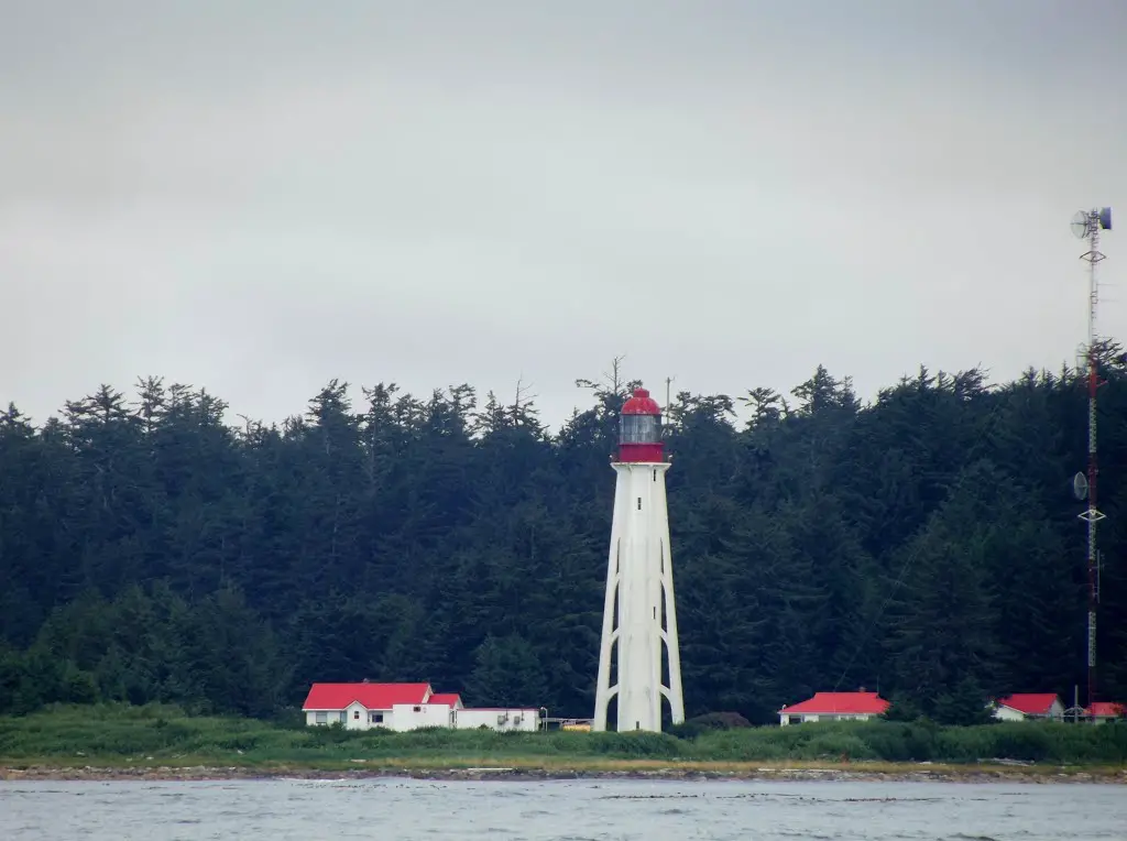
Estevan Point Lighthouse. Named for Perez’s second Lieutenant, Esteban Jose Martinez. A Japanese submarine fired shells at the lighthouse on June 20, 1942, the first attack on Canadian soil since the War of 1812. There are also various conspiracy theories about who actually did the shelling back then. Some attribute the firing to US or Canadian vessels as an attempt to get Canada to enter the war in the Pacific. As a result of the shelling Canadian war bonds sold at a great rate and a few months later Canada committed troops to the war effort in the Pacific.
Built in 1909, the 30m tall lighthouse is manned. Access a real bathroom and wood for a campfire.
DAY 3. Estevan Point to Hesquiat Village
Avoid the old plank road linking Estevan Point to Hesquiat village. It is clogged with trees and makes a poor alternative route.
Billion Boulder Beach. Past the lighthouse is tedious going across boulders of varying sizes. This stretch is about 7 kms long and there are no camping areas until Smokehouse Bay (has a small stream for water) before Matlahaw Point on the SE corner of the Peninsula. Pass Smokehouse Bay, round Matlahaw Point (another potential camp site) and head north away from the exposed Pacific into Hesquiat Harbour and Hesquiat Village. The only inhabitants in 2015 were Ignace and Dave, a couple who has lived here since 1975. The have a “store” selling homemade tequila fudge and mirrors lined with sea shells. A humpback whale vertebrae found here was radiocarbon dated to 1,500 years old. Pay to camp? Bring money for the store and camping.
DAY 4. Hesquiat Village to Le Claire Point
Finally the boulders give way to sandy beach after Antons Spit.
A stream pools up and creates a trench that cuts the beach in two. Wait for the tide to recede (and even then you may have to hoist your packs over your head and wade through chest deep water).
DAY 5. Le Claire Point to Cougar Annie’s Garden 4.6 miles
Follow two trails, the longest about 600m, through the forest up and over fallen trees and through sopping wet foliage before returning to the beach. Cross another tidal creek that may require wading up to your chest. The final short leg is a difficult stretch of shoreline leading toward Boat Basin.
First encounter a funky collection of wood cabins owned by Peter Buckland, a retired businessman who once owned Cougar Annie’s property. One is a Hobbit-styled cabin flanked by giant whale bones, a curved cedar-shake roof, porthole window, rock floor and leg-hold trap for a door knob.
Costs
Floatplane from Gold River
Air Nootka *all taxes and fees included
Gold River to Escalante Point – Beaver (6 passengers): $598.50 CAD * For safety reasons, we ONLY land at Escalante Point in the Beaver.
Hesquiat Lake to Gold River – Cessna (3 passengers): $441.00 CAD, Beaver (6 passengers): $598.50 CAD
Floatplane from Tofino
Tofino Air
Tofino to Escalente Point – Beaver only $881.50
Boat Basin to Tofino – Cessna 500.28, Beaver $709.50
Atleoair taxes not included
Depart Tofino to Escalente Point –
Cessna (3 passengers): $1104 CAD
Beaver (6 passengers): $1518 CAD
Cougar Annie’s Garden fees: $30 per person. Payable with Visa or Mastercard. Please email Boat Basin prior to your hike to set up the tour time: boatbasinfoundation@gmail.com
Black bears are a ubiquitous species inhabiting the sumptuous interface between forest and ocean. They are uncaring and generally ignore people. Carry pepper spray but probably unnecessary.
Information: BC Parks website provides information on the route, historic facts.
Wildside Guides by Philip Stone (wildside.ca/coastal-hikes/downloads/HesquiatePeninsula.pdf)
Cougar Annie’s Garden, by Margaret Horsfield (Salal Books, 1999)
John Baldwin’s Hesquiat Peninsula (www.johnbaldwin.ca/hesquiat-peninsula.asp) is a 1:50,000 scale topographic map with distances, hiking times, recommended campsites, tide cutoffs, sources of drinking water and noteworthy features.
What to Bring.
Sturdy hiking boots and hiking poles necessary to traverse the rocky coastline.
A VHF radio can give weather reports and offer emergency communication.
Good rain gear and a tarp.
Water must be filtered.
COUGAR ANNIE’S GARDEN
Ada Annie Rae-Arthur, later Ada Annie Lawson but better known as Cougar Annie, (June 19, 1888 – April 28, 1985) was a pioneer who settled near Hesquiat Harbour at Boat Basin in Clayoquot Sound on the west coast of Vancouver Island, Canada.
Early years. Born Ada Annie Jordan in Sacramento, California, she moved to the land where she was to live for more than 65 years from Vancouver, in 1915 after having lived in England, South Africa and the Canadian Prairies as a child. She arrived with the first of her four husbands to save him from an opium addiction and ensure that the remittance cheques that came from his family in Scotland would continue to arrive. At the time she and her husband settled on the coast, they had three small children. She gave birth to eight more children in this remote location. She acquired her nickname because of her famed marksmanship. She shot dozens of cougars during her long life.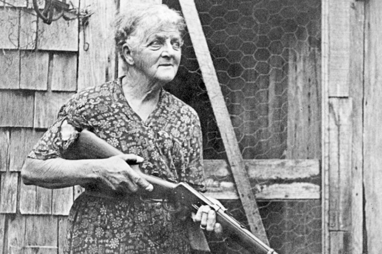
Stories
After the death of her first husband Willie Rae-Arthur in 1936, she advertised in The Western Producer saying “BC Widow with Nursery and orchard wishes partner. Widower preferred. Object matrimony.” The new husband she chose from several candidates died at their home in 1944 of an accidental gunshot wound to the leg. The story goes he was cleaning his gun and didn’t realize that there was a cartridge still in the chamber. Her third husband was produced by the same advertisement, and after his death of pneumonia in 1955, she ran another ad, this time seeking a widower with young children. Her own children having grown and moved off, she found a companion who stayed on with his children for a number of months before the remoteness of life in Boat Basin drove him away. However they did remain in contact for many years to come. (This previous statement has never been verified by the family.) In 1961 Annie married for the fourth and last time. It was an unsuccessful marriage to a man, 12 years her junior, who drank, stole from the store and sometimes beat her. This man tried to run Annie off a cliff to get the farm but she was wilier than he was and ran him off with her shotgun. When he left never to return around 1967, he was not missed.
In 1942 the lighthouse at Estevan Point was shelled by a Japanese submarine. Annie claimed to have seen the submarine surface in the harbour before the lighthouse was shelled and to have found a shell on the beach in front of her land.
The garden
With little help, Annie cleared 5 acres (20,000 m2) of her land and planted a sprawling garden. The garden was a source of income throughout her life, as she sold bulbs and plants by mail. She also operated a general store and post office from her plot of land. Another source of income over the years was a bounty offered for Cougars that ranged from $10 to $40. The numbers of cats that she claimed to have killed continued to increase into her old age but in 1955 she received bounties for 10 cats. At that time she claimed to have killed 62 cougars and about 80 bears. She killed the cougars and bears because they preyed on the goats and chickens that she raised.
Her livelihood depended upon the regular visits of the Canadian Pacific Steamships Line Princess Maquinna that arrived every 10 days in Hesquiat Harbour from 1913 to 1952 on her rounds from Victoria to Port Alice.
Annie rarely left the property where she lived until well into her nineties. Ailing and mostly blind, she was removed to Port Alberni, where she died at the age of 97.
The garden recovered. Her friend Peter Buckland, a retired Vancouver stockbroker, bought the property from her estate in 1985 and spent nearly fifteen years restoring the garden. He established the non-profit Boat Basin Foundation to manage the garden, which built and in 2007 opened the Temperate Rainforest Field Study Centre on a ridge overlooking the garden, in partnership with Ecotrust Canada and the Hesquiaht First Nation. In August 2010, the property was listed for sale, the study centre having been found to be not financially viable. NOTE: The sale of this property has been halted due to the “unmarked” cemetery, including Ada’s ashes and her first husband Willie. Family members and Peter Buckland were shown by Ada where most of the graves are, as Ada never put up a marker, she just planted something nice on top.

The garden has re-opened after seven years to small groups of people. It will seasonally open to the public on a limited basis (Fridays and Sundays) and is accessible by float plane from Tofino, or by hikers and kayakers.