
Libya is a country in North Africa with a Mediterranean Sea coast. More than 90% of the country is desert or semidesert.
WARNING: Since the overthrow of dictator Muammar Gaddafi in 2011, Libya has been the site of a violent struggle for power involving rival governments, many armed groups, and the support of foreign nations. The conflict has been crippling the national economy, killing thousands, and causing around 200,000 Libyans to be internally displaced. The ongoing crisis is made all the more tragic when considered alongside the country’s rich cultural history. Libya is home to five UNESCO World Heritage sites, including the remarkably preserved remains of Leptis Magna — described by the organization as “one of the most beautiful cities of the Roman Empire.”
Update 2022, Travel in Libya is very safe as one stays in the Tripoli/Ghadamas area. There was only one significant check point in the 600 km trip to Ghadamas. 
Capital: Tripoli
Currency: Libyan dinar (LYD)
Population: 5.6 million
Religion. 97% Sunni Muslim, small minorities of Christian and Jewish people.
Climate. Mediterranean in most of the coastal lowland, with warm summers and mild winters and scanty rainfall. The weather is cooler in the highlands, and frosts occur at maximum elevations. In the desert interior the climate has very hot summers and extreme diurnal temperature ranges.
Language. Standard Arabic is the official language, but the native language is Libyan Arabic. Arabic languages are mutually unintelligible. English is widely understood especially by young residents of Tripoli, while older people are likely to speak Italian.
Country Code: +21
Visa. Passports and visas are required for entry into Libya for all nationalities except nationals of Algeria, Egypt, Jordan, Mauritania, Morocco, Syria, Tunisia, and Turkey. Those with passports indicating travel to Israel will be denied entry. Apply in your home country.
Libya has no tourist visas – only business visas. Visa approval fee (150€) through the Department of Passports and Citizenship and Foreigners. This fee must be paid in advance before submission. Libyan embassies cannot issue visas if they do not receive the visa approval codes, Typically, applicants obtain their visa in their country of citizenship or residence.
Present your documents including passport, visa form with 2 photos, I paid by debit card.
1 Month single entry VISA $102.50.
Include a prepaid return envelope.
Embassy of Libya, Consular Section, Unit 1100, 170 Laurier West Avenue, Ottawa K1P5V5 (613) 842 7519, (613) 680 2009 / fax: (613) 842 8627 / info@embassyoflibya.ca
150€ visa application fee paid to the tour operator + CAD$102.50 for a one month visa at the embassy (payable by debit).
By plane. Libyan Wings Airlines and Tunisia Airways are the main airlines of the country. Since 2022, flights land at (MJI), just south of Tripoli.
Tour Operator. Sherwes Travel +46(0)708454361 info@sherwestravel.com. Ibrahim Usta
Cost. 1750€ or US$ 6 nights/7 days. preferably as cash. Includes: airport transfers, 4 nights at Jakarta Hotel and 2 nights in Dar Ghadames Hotel, Meals full board, English-speaking guide, Entrance fees.
Currency: Libyan dinar (LYD). ATMs and international credit cards don’t work. Bring everything as cash. This is a black market money country so one would not want to use ATMs.
Sept 8-9 Fly Montreal – Paris – Tunis – Tripoli (LRT3OQ $672) YUL-ORY @17:20-06:20+1 (4’0″ Corsair SS901) / ORY-TUN @10:20-11:45 (2’25” Tunis Air TU717) / (LRTIWO) TUN-MJI @ 18:10- 20:20 (Hahn Air HI6647 – Libyan Wings)
I had an uneventful 27 hours of flights to reach Tripoli. In Tunis I made sure to declare all my currency as there are limits on what can be taken out of Tunisia. I went through Transit and didn’t pass immigration.
LIBYA Sept 9-15 2022 “Ghadames Tour”
Itinerary Summary
Day 1 Fri Sept 9. Flight Tunis-Tripoli (LRTIWO) TUN-MJI @ 18:10- 20:20 (Hahn Air HI6647 1’10” $320)
Day 2 Sat Sept 10. Jebel Nafusa, Qasr al-Haj, Tarmeisa, Jadu, Ain az Zarqa – ON Ghadames (B, L, D)
Day 3 Sun Sept 11. Ghadames WHS. ON Ghadames. (B, L, D)
Day 4 Mon Sept 12. Drive to Tripoli via Gharyan.
ON Tripoli (B, L, D)
Day 5 Tue Sept 13. Sabratha WHS, Tripoli Old Town ON Tripoli
Day 6 Wed Sept 14. Leptis Magna. Flight Tripoli to Tunis MJI-TUN (LRTNQS) 20:00-20:10 (Hahn Air HI6655 $301)
ITINERARY 6 days 5 nights “Ghadames Tour” Sept 9-15 2022
Day 1 Fri Sept 9. Arrive Tripoli, Jakarta Hotel. Airports: Tripoli (MJI)
The Libyan Wings flight from Tunis was full, virtually all men that are nationals of Libya.
I was first in line at immigration and last out, time spent while immigration contacted my driver. They asked several times about my business association.
I arrived at the hotel at 10 pm and basically went to bed as I was very sleep deprived from all the flights.
Day 2 Sat Sept 10.
Tripolitania (Tripoli, Surt, Zuwara). The north-western region on the Mediterranean Sea with the capital city and ancient Roman ruins.
TRIPOLI (pop 1.1 million) is the capital and largest city of Libya, It is located in the northwest of Libya on the edge of the desert, on a point of rocky land projecting into the Mediterranean Sea and forming a bay. It includes the port of Tripoli and the country’s largest commercial and manufacturing center. It is also the site of the University of Tripoli. The vast Bab al-Azizia barracks, which includes the former family estate of Muammar Gaddafi, is also located in the city. Colonel Gaddafi largely ruled the country from his residence in this barracks.
Tripoli was founded in the 7th century BC by the Phoenicians, before passing into the hands of the Greek rulers of Cyrenaica as Oea. Due to the city’s long history, there are many sites of archeological significance in Tripoli.
Traditional walled medina with labyrinthine streets that remains quintessentially North-African, with many beautiful mosques, fountains and statues to remind of its historic role in the great Ottoman Empire. Tripoli was called “A City of the Orient”.
Italian architecture in three neighbourhoods immediately south of Martyrs ́ Square.The breakfast at the hotel was lavish but I had no appetite. At 08:30, I met my guides and paid cash for the trip US$1750. I met my tour group and we left Tripoli for Ghadamas, a 600 km, 7-hour drive. It was a nice 11-passenger van. We used the guides wifi hotspot to connect to the internet.
After passing through the outskirts of Tripoli, the flat terrain initially was olive trees, then low brush and desert. The ditches are full of garbage. Military checkpoints were common and fast. The road is good 2-lane pavement.
Jebel Nafusa – 70 km south of Tripoli is this wall of rock that rises 750 m abruptly from the desert plain to 968 meters. Mountains are bare, rugged, and without vegetation. Plains full of olive, fig, fruit trees, and vineyards. Heartland of the Berber people.
We passed three tanks from the Quaddafi era arranged into a “monument”.
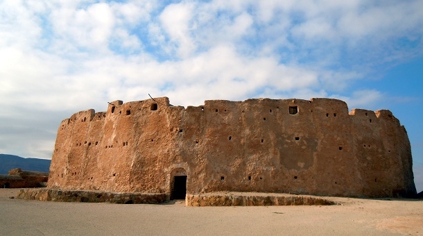
Qasr al-Haj This 12th century fortified granary has 141 storage crypts and 30 tunnels (used for storing water and oil) in a round 3-story complex. It was used by groups on the way to Mecca. Each had a door – the hinge is hard olive wood and the door soft palm wood. All are divided up by low walls for sons and grandchildren. There is residual wheat, barley and some amphorae. A man stored wheat in 1968, returned in 2008 and the wheat was still good. It was possible to walk around the upper level.
A large, round, elevated metal “tray” held 2500 kg of couscous when they surpassed the largest couscous dish in the world for a Guinesss World record. 4 small alcoves had kitchen utensils, agricultural tools, Koran tablets, and fossils of an ostrich egg and petrified wood.
It was surrounded by ruins of several buildings used as accommodation for pilgrims. A large well still had water in it.
From Wikipedia: It is a huge fortified granary of circular shape built in the 13th century AD about 130 km from Tripoli. It was built to serve as granary for families from the surrounding area in return for quarter of their crops, which, it is said, the owner had endowed as a waqf for teaching Qur’an and Islamic related subjects to the people of the area. The building originally comprised 114 chambers, which could be the number of the subscribing families during the time of construction. It is also speculated that the number 114 was used symbolically to reflect the number of Sura in the Qur’an, a view widely accepted by villagers in the region nowadays. The number of chambers as of now, is 119, as result of splitting 10 chambers due to inheritance disputes. Other changes include the addition of 29 cellars.

After the Qasr, it was a long, switchbacking climb up into the Nafusa Mountains. At noon, it was very hot – in the low 30s.
Nafusa mountains are in the western Tripolitania region of northwestern Libya. Rise to over 750 m (2,500 ft), rarely more than 25km wide and 250kms long. The plateau ends abruptly on the north with a 350m escarpment. The mountain villages raise primarily goats, olives and grain, but also have fig and apricot orchards.
It has most of Libya’s Berber-speaking population, who speak Nafusi Berber and practice Ibadi Islam frequently at odds with the largely orthodox Sunni population of the rest of Libya. A distinct culture, suppressed and oppressed by the Libyan regime.
In the Libyan Civil War 2011, the Nafusa Mountains becoming a major front for anti-Gaddafi protests in that war. The terrain favours guerrilla tactics. 45,000 refugees in the war went to Tunisia. Berber exhibitions and workshops spread the Tamazight culture and language, after four decades of repression.
Tarmeisa – A deserted, ancient stone village on a narrow rocky outcrop overlooking the Sahel Al Jefara, with its hundreds of valleys to the north. Established ~750 years ago, it was lived in until the 20th century. Maybe as many as 100 people lived here in houses constructed of stone walls and stone columns supporting olive/palm tree/rock roofs. Each family also had an underground home. There was a complete olive oil production facility with a large grinding wheel and a press – all of huge stones. The large roof was constructed identically to Anazasi kiva roofs. A courtyard led to a mosque at the end and large rocks on the edge of the cliff.
Shortly after we stopped at a lovely restaurant for lunch – a spicy soup, salad, naan and a small tureen full of couscous, baked squash and baked chicken.
Jadu – capital of the Nafusa Mountains.
After Jadu, the desert was one of the driest I’ve ever seen (comparable to the Atacama) – no plants, small rocks and sand.
Ain az Zarqa – natural spring with a small, crystal-clear pool fringed by palm trees surrounded by cliffs on three sides. Also waterfalls, streams, farms, troglodyte dwellings, cliff-top houses, and groves. Al-Barouni Museum – ethnography, architecture, crafts and
archaeological stone artifacts.
Ghadames, one of the most ancient towns in the Libyan Desert. ON Ghadames Stars
Hotel. (B, L, D)
Day 3 Sun Sept 11. Ghadames. An oasis town on the trans-Saharan caravan routes between Timbuktu and the Mediterranean coastal cities of Libya, it sits in a huge southern desert region with amazing scenery and some of the hottest temperatures recorded anywhere in the world. Ghadames is virtually on the Algerian border near the south tip of Tunisia. The ruins of its ancient theatre, church and temples are a major attraction.
Old Ghadames was surrounded by a semi-circular wall. Buildings are constructed of sunbaked clay bricks on seven main streets each with a small square used for public gatherings. Narrow roofed alleyways connect the main streets so that houses are joined allowing running along the rooftops. Men traveled along the lower streets whilst women used the upper streets between sunrise and sunset. Atmospheric with unique Saharan architecture.
My experience. Our guide was Mohammed Ali, a 66-year old former air traffic controller who is now retired.
Ghadames was founded before Christ as the Romans were here. In 551 – Ottomans, 1911 – Italy occupied until 1943. On Jan 11, 1943, the old town was bombed by the Americans and British. 13,500 kg of bombs were dropped destroying 70 houses and severely damaging 200, 40 died, all Libyans,as the bombing had no effect on the Italians (there was a plaque on one wall commemorating the event). French – 1943. Independence 1951, Quadaffi 1969-2011. The new city was started in 1970 and by 1982, all residents of the old town had left and moved. They then had running water, flush toilets (only dry toilets in the old city) and air conditioning. It is now virtually empty but there were small groups of men hanging out.
There are 7 gates through the 3-4 story walls. The walls are heavily buttressed on the outside and the walls remudded as needed so all are in good shape. The houses are 3-4 stories. We walked down Jerasan Street passing the closed Juma Mosque. The street is about 6-7 feet wide, has palm tree joists and light wells ever 10-20 metres. Doors to the houses have palm tree boards. Ones with multiple yellow/green/red leather patches indicated that the occupant had been on the Haj to Mecca. Originally the only address for mail was the owner’s name and street, but house numbers were added later. Electricity arrived in 1962. Niches in the walls held candles.
Jersan Street turned into Tingazin Street, now with arched ceilings and wonderful geometric designs painted on the walls. Inset designs were also very nice. Multiple side streets branch off creating a maze of narrow alleys.
School. Supposedly the oldest in Libya, the school graces the Libyan 20 Dinar money note. Views from the roof looked out to the oasis and palm trees in one direction and back into the old town the other way. The walls were decorated with geometrics.
We walked down Tafarfara Street to the main square and the large spring that supplies water to the town. It is a big, deep pool with 5 channels branching off to supply water to the town and fields. Kids were swimming as the water now is not used for drinking but only ablutions and for agriculture. The guide explained the water distribution system. A large bucket could be emptied in 3 minutes, one hour was allotted per farmer and so was able to fill 20 buckets of water.
We saw many mosques, most closed. The active “new” mosque had 16 square columns. The “ancient” mosque was locked behind a bright green door. The “old” mosque dated from 668 AD.
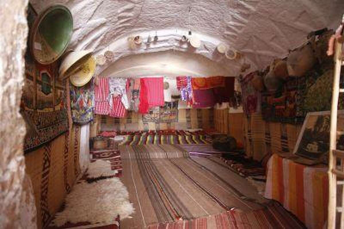
Dan Magrouma House. Over a thousand years old, this fantastically decorated house is the most famous in the old town. The front door has the markers indicating attendance at a least one Haj. First floor were stores. Second floor: large two-story room with carpets, pillows lining the walls and walls covered with mirrors, copper bowls and woven tagine covers. All the doors and small cupboard doors were fantastically designed and painted in the three colours of yellow, green and red. Third floor: kitchen. Fourth floor: roof. A special room off the main room was used for weddings, circumcisions and as the 4-month and 10-day mourning period for women after their husband dies (when they are only allowed to go to the toilet. She is visited by family and friends.
We had lunch in the main room (cucumber/tomato salad, soup, bread, rice and lamb) and then returned to the van to return to the hotel and a siesta.


Sunset at the steep dunes close to Ghadames. We hired 2 4x4s to go out to the dunes at 6 pm. We stopped first at Qasr Al Ghoul (ghost), a large rock with stone walls on top. It was a short hike to the top. There was an incredible well that must have been the depth of the mountain.
The boys driving the 4-Runners stopped and let air out of the tires preparing to drive on the dunes. They accelerated hard and kept the revs high in low gear to climb the dunes like a dune buggy. We drove all over even on the crest of steep dunes where it got kind of freaky. They drove around so much that we missed sunset, which would have been very ordinary with no clouds on the horizon.
We returned to town well after dark, had coffee at a 1000 year-old house and then another over-the-top meal. The volume of food is massive – a salad, soup, and then a large plate of rice, chicken, tagine (very good with potato base, spiced meat and pastry on top), French fries and vegetables. I didn’t bother with the large plate. Then came a large plate of fruit.
ON Dar Ghadames Hotel. (B, L, D)
Day 4 Mon Sept 12. Drive to Tripoli via Gharyan. This was a slightly different route than we took on the way to Ghadames.
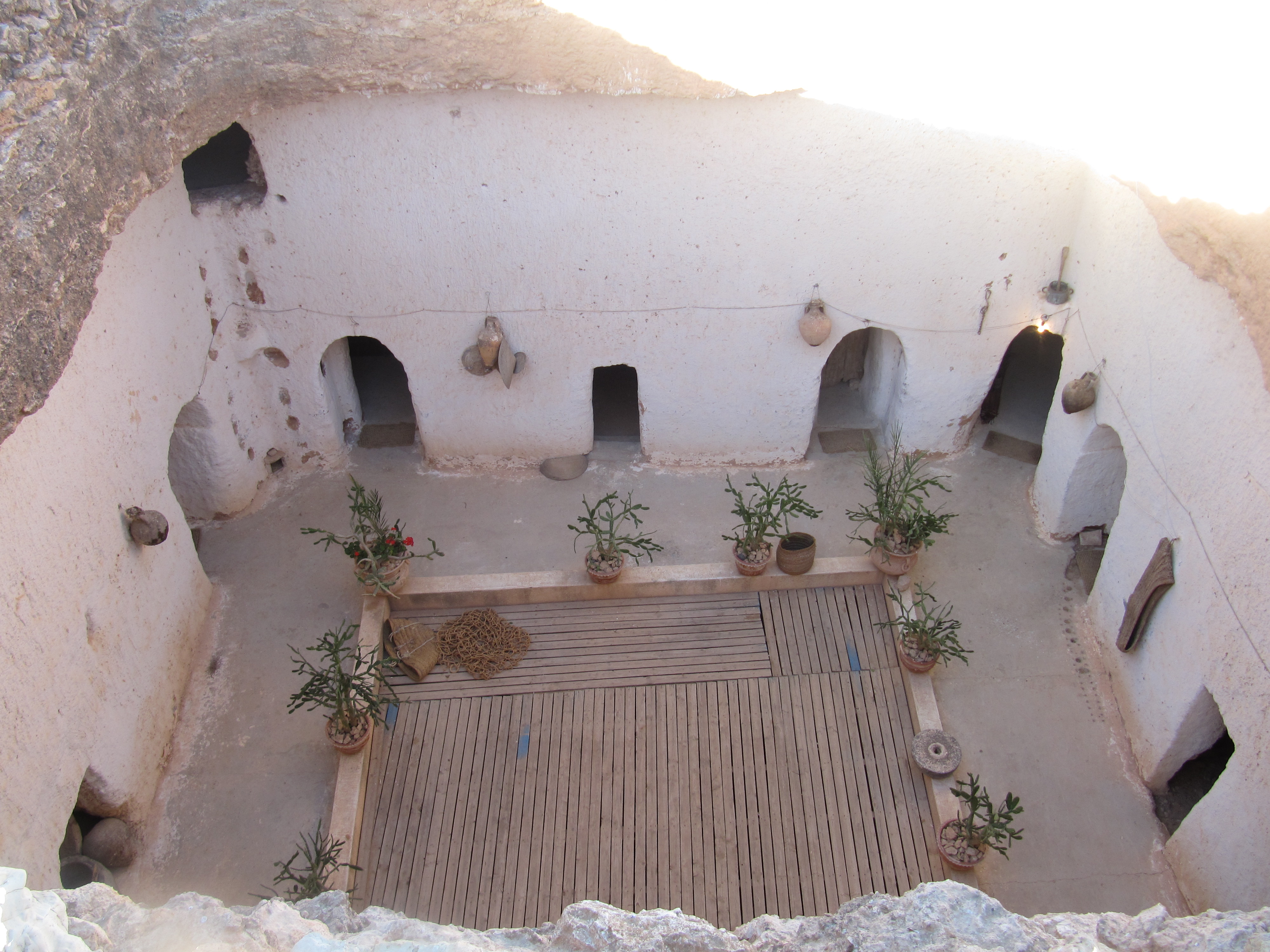
Gharyan (pop 85,219) lies at the foot of the Nafusa Mountains, 50 miles (80 km) south of Tripoli. It was on the trade routes both south to Fezzan and over the Nafusa Mountains. Olive oil processing, flour milling, carpet weaving, and pottery (Al-Qawasem). Troglodyte caves are famous and “Ghar” means “cave”. The caves were dug vertically down into the rocky ground.
Belhaj Troglodyte Home. We had lunch in the only troglodyte home open to tourists (there are 3000 troglodyte homes in Gharvan – each family had one). This one was built in 1666, is square, and had 8 main rooms (and 8 families). This was last lived in the 1990s although the young guide says he sleeps here every night. The temperature is 20-24°C year around. There were two tiny kitchens, a bread making area and a large room that may be converted into a hotel with 6 rooms.
The entire centre is a 2m deep pit covered with boards to drain any rain water. They threw their bones in the pit and ants created an ideal drainage system.
We had another large lunch of the usual – soup, salad and rice with chicken and nuts.
Gharvan is known for its pottery and we stopped at a large complex of pottery stores.
 Cave dwelling Jews, also cave Jews or troglodyte Jews (from the French phrase “Juifs troglodytes”), were Jewish communities that dwelled in man-made caves in the mountains. The best known communities of this type existed in the Gharyan Plateau (“Jebel Gharyan”) area of the Nafusa Mountains in Libya, and are commonly referred to as Gharyan Jews. These communities no longer exist today.
Jewish tribes living in manmade caves were known for centuries in Morocco, Algeria, and in Tripolitania. Their homes and synagogues were in caves; only cemeteries were on the surface. Jewish cave dwellers of Libya were known since at least 70 C.E., when Romano-Jewish historian Josephus described the Troglodytis. When Spain invaded Tripoli in 1510, many Jews fled to Gharyan (among other places), and these Jews brought with them Sephardic traditions.
After Libya gained independence, most Jews, including those of Gharyan, migrated to Syria to make aliyah due to worsened conditions such as pogroms.
At present, many of these caves are occupied by Libyans, who modernized the dwellings, including the addition of electricity, running water, and sewage disposal. A number of advantages exist to this type of dwelling. Some of these cave homes are also rented out to tourists.
ON Jakarta Hotel, Tripoli (BLD)
Day 5 Tue Sept 13.
SABRATHA. WHS dating to 500BC. The Phoenicians used Sabratha as a seaport and important trading post. Romans. City damaged in the fourth-century earthquake. Rebuilt to become one of the most popular tourist attractions in Libya today. The 175AD Theatre has a large forty-three-meter stage, and held 5,000 spectators. Also baths, temples, and the spectacular amphitheater which housed up to 10,000 spectators
Tripolitania (Tripoli, Surt, Zuwara). The north-western region on the Mediterranean Sea with the capital city and ancient Roman ruins.
TRIPOLI
After returning from Sabratha, we had the afternoon to see the sites in Tripoli.
Italian architecture in three neighbourhoods immediately south of Martyrs ́ Square.
Tripoli Congress Center. Modern Architecture Buildings. A semi-transparent perimeter “shield” of designed bronze mesh surrounds the building, protecting the inner glass walls; an 8 meter corridor encircles all three sides; the main building is flanked by a 4-meter wide reflection pool and another 4 meter is left as a semi-open shady circulation area. The water elements provide a cooling effect before the building, in addition to its esthetic contribution. The semi-open corridors create a sound waft in the circulation zone. The metal mesh walls carry incise patterns that are inspired by the trees that surround the site, permitting controlled daylight to diffuse into the central space.
The texture is visually an extension of the tree branches as a complementary of the woodland. Glass wall systems allow for the maximum viewing area

Old Town Tripoli. 48 hectares in size, it is surrounded by a wall of blond stone. It has no vehicles and is a maze of lanes and shops.
Arch of Marcus Aurelius – The triumphal arch of Marcus Aurelius is Tripoli’s most impressive ancient monument as Marcus Aurelius riding triumphantly in his chariot and embedded with relief sculptures. At the intersection of Cardo and Decumanus and, therefore, marks the exact center of the Roman city. It was built in 163 AD and dedicated to the joint emperors, Marcus Aurelius and Lucius Verus. At various times in its history, it has been incorporated in a Roman forum, a storehouse, stables, a shop, a public house, and a cinema. The base of the arch is now 10 feet below street level.
Gurgui Mosque. Built in 1834 by the the naval captain Mustafa Gurgi. To the right of the entrance are the tombs of Gurgi and his family. It mixes European and Islamic geometrics. The walls and columns are natural marble, and its flooring multi-colored tiles. The minaret is 25 metres tall with two balconies made of genuine green marble. Other features include an arched entryway engraved with floral designs, 15 decorative domes, and calligraphy on the walls.
Tripoli Cathedral. This Anglican church is plain white inside with few adornments. The 8 columns have dark brown intricate capitals.
Banco di Roma building – Ottoman-era mansion, courtyards with tiny pools.
Red Castle Museum (Archaeological Museum of Tripoli). Closed because of Covid.
Karamanly House Museum. This is a historic house and museum located in the Old city associated with the Karamanli dynasty. The house was built in the second half of the 18th century. After restoration in the 1990s, it became a museum. It is one of the few traditional houses that have been preserved and rehabilitated in the Old city. It is characterized by its fine Islamic architectural design. It consists of two floors, an open air courtyard, with a fountain. The arches serve both a decorative as well as a load-bearing purpose. Mosaic patterns also adorn the walls.
Ottoman Clock Tower. This 3-story, square, white tower has a clock on all 4 sides. This is the place to get money changed (especially for black market money.
Souqs are of great commercial value as they were the middlemen between trans-Sahara trading routes, within Tripoli, and southern European Merchants ships.
Souq al-Attara (was the spice souq, now gift and gold jewelry shops. Souq al-Ghizdara (coppersmiths). Souq al-Turk (dates from 1687-1702 and roofed 1795-1832. Near are the fundq of Othman Basha of 1654. During the Italian occupation, this fundq became the
Polytheama cinema and presently Al-Nuser cinema. The site also contains the mosque of
Mohammed Basha of 1699 and the first municipal town hall-seat of Tripoli in 1870.
Souq al-Ruba – from 1649-1672) with a typical vaulted brick ceiling, traditional clothes.
Ahmed Pasha Mosque. This lovely mosque in the souk has 16 columns and 12 feet of tiles and lovely jali screens for walls.
An-Naqah Mosque. This small mosque is unique in that none of its 36 stone columns and their capitals match. They look like they were scavenged from every ruin around.
Martyrs’ Square A very plain square with no adornments. Many pigeons and people and two columns with a ship and horse on top. Gaddafi made a famous speech from a balcony on the side of the square. This is a meeting place for the locals and the venue for national celebrations.
Security Police warned against taking any photos of cars as some may be security related.
Algeria Square and Mosque. The mosque was built by Mussolini in 1923 and converted into a mosque in 1980 when a minaret was added and the interior significantly redesigned. With a lot of brown wood, it is not very attractive inside. We had a shisha at a lovely outside restaurant on the square.
Royal Palace. I was up early and tried to see it before breakfast as it was a 5-minute walk from my hotel. We walked back from the Old Town in the evening and hoped to see it thel It was open but security wasn’t keen on us entering, After some discussion, we were eventually given a complete tour and saw ever room.
It was built during the rule of Italo Balbo in the 1930s. It was used as the seat of the Italian Governor General, and during the British Mandate period, it became the seat of the English Governor, then the seat of King Idris Al-Senussi during the period from 1951 to 1964.
Its interior walls are decorated with motifs, murals, and beautiful paintings by famous Italian artists and sculptors. After the September 1969 coup, the palace suffered from neglect and negligence, and most of its contents, including furniture and artistic paintings, were lost. It was affected by some damage following the US raid on Libya in 1986, and it was converted into a museum and called the ‘Libya Museum’.
It has a wide range of objects from the WHSs, photography, scale models of developments, and many artifacts.
A wedding was being held in the courtyard and we watched and listened to the 21-piece band. After seeing the palace, we walked through the wedding.

ON Jakarta hotel. (B, L, D)
Day 6 Wed Sept 14.
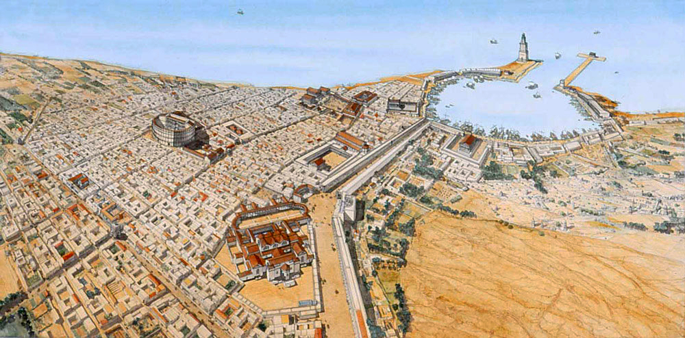
LEPTIS MAGNA (“Great City”) – 130 km from Tripoli, it was originally a Phoenician trading port from about 700 BC and prospered for nearly 1000 years before Vandal invasions and sandstorms brought its downfall. In its heyday during the reign of Libyan Emperor Septimius Severus (145-203 AD, born in Leptis Magna, emperor from 185-203, died in York England), it was second only to Rome and housed over 100,000 people. It was abandoned in the seventh century and got buried under layers of sand until excavated in the early 20th century. Only 30% has been excavated – the rest lies under 10-20 feet of sand.
The site is one of the most spectacular and unspoiled Roman ruins in the Mediterranean full of large, spectacular structures. The most impressive for me were the marble and columns, all imported from southern Europe: Cararra marble from Italy for the floors and walls, Egypt, Malta and the most spectacular Cipollino marble (“onion-stone”), a variety of marble used by the ancient Greeks and Romans quarried in several locations on the south-west coast of the Greek island of Euboea, It has a white-green base, with thick wavy green ribs, held onto the path by strata of mica. It became common throughout Rome during the imperial period. It was principally used for column shafts, but not often for sculpture as it did not carve well. The walls are all sandstone and the streets limestone as it was much harder.
Arch of Septimius Severus (most inscriptions have been replaced but it is still very impressive.

Hadrian’s Baths. A huge bath where the sandstone walls are covered with a layer of clay, then marble to make them waterproof. The toilet was large with marble benches, running water.
Collonaded Street.

Next to the forum is a basilica with granite columns and exquisitely carved columns.

We then walked down to the water. Three large Cipollino columns lay on the beach, left by the French.
Theatre. Built by the Romans between the first and third centuries AD, it has a large stage and all its original seats for 10,000. Outside the theatre are two massive cipollino marble columns.
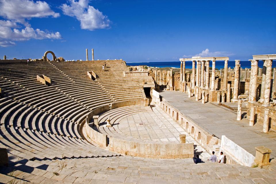
We then drove to:
Amphitheatre of Nero. Built by Nero in 45 AD, it is 70 m high and 70 m round and could hold 15,000 spectators. It was used for “blood sports”.

Harbour. The largest in the Roman world, it is now completely silted in. The docks and storehouses on one side have been excavated. It had a lighthouse modelled after the Alexandria lighthouse.
Departure. Flight Tripoli to Tunis MJI-TUN (LRTNQS) 20:00-20:10 (Hahn Air HI6655 $301). I left the group on the highway into Tripoli and was driven to the airport by another Sherwes employee. Exchange all your Libyan money here as it is not possible to exchange outside the country.
Tour Operators
1. Sherwes Travel, Jamhuria Street 24, Tripoli, Libya www.sherwestravel.com, email: info@sherwestravel.com, www.facebook.com/sherwestravellibya)
Ibrahim Usta; E-mail: Ibrahimusta@sherwestravel.com +46708454361
Tour guide Ramses. Very good, masters degree in tourism from Sweden.
2. *Wadi Smalos Tourism Services. Abubaer Abusahmen +218 913633082 abubaker@smalos.com. He was unable to procure visas so was not offering trips in the fall of 2022.
The country in 2019. Tourists who visited Libya in 2019 felt the country was very much on edge. Trash collection was practically nonexistent. Trash is strewn everywhere, both in the cities as well as along the roads. There are piles of wrecks of cars. There is no upkeep for public parks and spaces. Museums are closed to protect displays from being vandalized and looted. Driving in Libya is dangerous, with drivers making unexpected moves. Salem frequently used his phone while driving, which was unsafe, given the unpredictability of traffic.
SEE
Misrata. Flights prior to 2021 landed in Misrata, 200 km from Tripoli.
Misrata War Museum on Tripoli Street. It was on this street where the most intense fighting between the Gaddafi forces and the rebels was held. On display outside are the destroyed Russian tanks, weapons and ammunitions (bullets, bombs, rockets, mortars, projectiles) used during the First Libyan War of 2011 that brought down Gaddafi. His body was publicly displayed at this place following his capture and death.
Archaeological site of Ghirza Tentative WHS. Ghirza is a frontier pre-desertic site about 250 km southeast from the coast. 500 m by 300 m. Cluster of 40 structures ranging from small, one-room buildings to large fortifications, a temple and two burial grounds with richly decorated mausolea made of ashlar. Ghirza was a privileged centre with most of the surviving funerary monuments date from the late third and fourth century AD. A period of prosperity under emperor Septimius Severus when part of the limes Tripolitanus, the southern frontier of the Roman Empire. It was a commercial hub between the desert and the coast. Hunting scenes on camel or foot, grapes, fish and ostrich hunts.
The boundaries of the Roman Empire were modified throughout its history, reaching its greatest extent during the 2nd century AD. On the southern frontier, was the Sahara Desert with the limes Tripolitanus, was reorganised through a reform of by Severus around 200 AD
Decorative repertoire, the civilian architecture and standing buildings
CYRENAICA (Benghazi, Shahhat, Tobruk). The north-eastern region on the Mediterranean Sea.
Benghazi — the largest city of Cyrenaica and the second largest of the country
Tobruk — harbour town with World War II cemeteries
Shahhat— Ancient city of *Cyrene, a World Heritage site, is nearby. Another must-see, Cyrene, an ancient colony founded in 630 BC as a settlement of Greeks from the Greek island of Thera. It was then a Roman city in the time of Sulla (c. 85 BC) and now an archaeological site near the village of present-day Shahhat and Albayda.
Green Mountain (Jebel Akhdar) is a heavily forested, fertile upland area cut by several valleys and wadis at an altitude of 900 metres in northeastern Libya. It forms the north-western part of the peninsula that sticks north into the Mediterranean Sea runs from Bengazi eastward to just east of Derna, fronting the coast for about 330 kilometres (210 mi). Due to erosion and deposition the plateau is sometimes as much as 16 kilometres (9.9 mi) from the shore, but it forms cliffs on the headlands.
The region is one of the very few forested areas of Libya, which taken as a whole is one of the least forested countries on Earth. It is the wettest part of Libya, receiving some 600 millimetres (24 in) of precipitation annually. The high rainfall contributes to the area’s large forests containing Chammari, and enables rich fruit, potato, and cereal agriculture, something of a rarity in an arid country like Libya. Camels, goats and sheep are herded in and around the Jebel Akhdar and the herders tend to be nomadic.
The ancient Greek colony of Cyrene was located in a lush valley in the Jebel Akhdar, with the ruins remaining. It was the Greeks who introduced farming to the Jebal Akhdar when they colonised its verdant valleys in around 600 BC.
The Libyan leader Omar Mukhtar used this heavily forested mountainous region to resist the Italian military occupation of Libya as Italian colony for more than twenty years.
++++++++++++++++++++++++++++++++++++++++++++++++++++++++++++++++++++Libya – Tripolitania (Tripoli, Misrata, Sirte, Ghadames)
World Heritage Sites
Archaeological Site of Leptis Magna
Archaeological Site of Sabratha
Old Town of Ghadamès
Islands: Farwa island
Borders
Libya (sea border/port)
Libya-Tunisia
XL: Sirte
World of Nature: Karabolli
African Cities
KHOMS
MISRATA World Cities and Popular Towns
SIRTE
ZAWIYA
ZUWARA
GHADAMES
World Heritage Sites: Old Town of Ghadamès
XL: Ghadames
Museums: Ghadames: Ghadames Museum
SABRATHA
World Heritage Sites: Archaeological Site of Sabratha
TRIPOLI World Capitals World Cities and Popular Towns
Airports: Tripoli (TIP/MJI)
Museums: Tripoli: Red Castle Museum (Archaeological Museum of Tripoli)
House Museums/Plantations: Tripoli: Karamanly House Museum
Castles, Palaces, Forts: Tripoli: Royal Palace
Religious Temples
Tripoli: Gurgui Mosque
Tripoli: Tripoli Cathedral
Modern Architecture Buildings: Tripoli Congress Center
Zoos: Tripoli: Tripoli Zoo
Markets: Tripoli Souq
ZLITEN
Modern Architecture Buildings: Zilten: Al Asmarya University building
==============================================================
Libya – Cyrenaica (Benghazi, Jabal al Akhdar, Butnan, Derna, Marj, Al Wahat)
World Heritage Sites: Archaeological Site of Cyrene
Islands: Barda’a island
Borders
Egypt-Libya
Libya (sea border/port)
World of Nature: El-Kouf
African Cities
AJDABIYA
BAYDA
MARJ
DERNA
Waterfalls: Derna Falls
TOBRUK
The Dark Side: Tobruk: Tobruk World War Cemeteries
BENGHAZI World Cities and Popular Towns
Airports: Benghazi (BEN)
Religious Temples: Benghazi: Atiq Mosque
Modern Architecture Buildings: Benghazi: Ad Dawah Al Islamiyah Building
Zoos: Benghazi: Benghazi Zoo
Lighthouses: Benghazi Lighthous
==============================================================Libya – Fezzan (Sabha, Ghat, Murzuq, Jufra, Wadi al Shatti)
World Heritage Sites: Rock-Art Sites of Tadrart Acacus
Borders: Chad-Libya
XL
Al Jufrah Oasis
Jebel Acacus
Murzuq province
Northern Tibesti (Wath)
World of Nature
Acacus Mountains
Waw an Namus volcano
Zellaf Reserve
Lakes: Ubari Lakes
Caves: Tadrart Acacus Desert Cave
African Cities
SABHA
Villages and Small Towns
GHAT
Castles, Palaces, Forts: Ghat: Ghat Fortress
Festivals: Ghat Festival
=============================================================
Libya – Cyrenaica – Kufra (Libyan desert)
Borders
Chad-Libya
Egypt-Libya
African Cities
KUFRA