
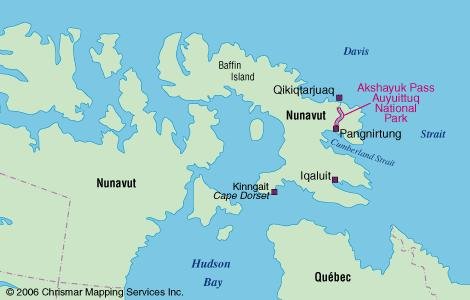
AUYUITTUQ NATIONAL PARK
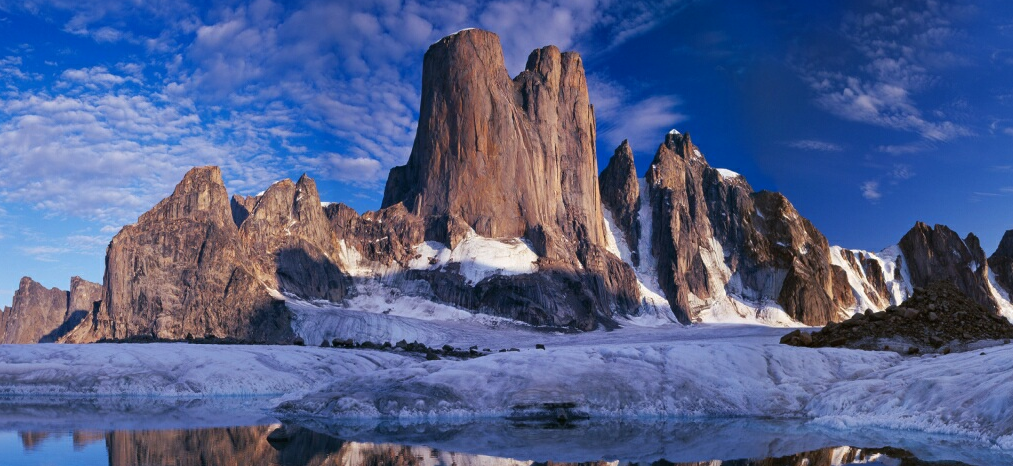
Located on eastern Baffin Island between the communities of Pangnirtung and Qikiqtarjuaq, Auyuittuq (pronounced ‘ow-you-we-took’) National Park is the most accessible national park in Nunavut and the most popular. The landscape is 85 percent rock and ice, dominated by steep and rugged mountains, with vast glaciers and powerful rivers.
It’s a frozen expanse of snow, ice and rock – tucked away from most of humanity. Auyuittuq National Park boasts a polar ice cap the size of Prince Edward Island, glaciers galore, icy rivers, fjords, lichen-covered rocks and Mack truck-sized boulders casually strewn about by retreating glaciers.
History
The Inuit living in the Cumberland Sound area had relatively little contact with Europeans until the 1820s when the whaling industry developed. Local Inuit began settling into the community of Pangnirtung (‘place of the bull caribou’) in the 1950s and ’60s.
The community of Broughton Island (now called Qikiqtarjuaq) was established in 1955 as a DEW (Distant Early Warning) line station during the Cold War.
Most Inuit families from the surrounding areas eventually settled into this community, although they continued to live off the land and harvest ‘country food.’ A visit to Pangnirtung and Qikiqtarjuaq offers great opportunities to experience the rich Inuit culture. They are worthwhile places to spend a few extra days on either end of an excursion through Auyuittuq.
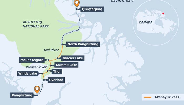
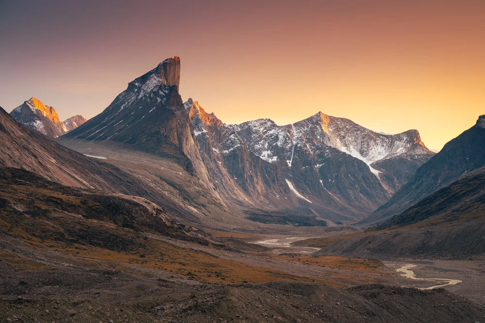
AKSHAYUK PASS. The main hiking route is a 97-kilometre (60-mile) traditional Inuit travel corridor through the park from coast to coast, following the Weasel River Valley, a glacial valley and unmistakable corridor bordered by sky-scraping mountains. Despite no designated trail to follow, the pass follows significant landmarks. The towering granite peaks of Overlord, Odin, Thor (at 1250m high, it is the second-tallest rock face on earth and overhangs at 105°) and Asgard peaks guide you through this spectacular landscape. This route requires about eight days (one-way). Extra time should be allotted in case of bad weather and river crossings that can affect your schedule at any time in the season.
Mount Thor can be found about 46 km from Pangnirtung in Nunavut. It’s a place that makes you think about what’s possible.
The Route. It traverses the park over 97 kilometres from the head of the North Pangnirtung Fiord (82 km from Qikiqtarjuaq) to Overlord on the Pangnirtung side. The trail is not technical and has no altitude challenges. Glacial river crossings in August are usually watered up to your knees. While there is no distinct trail to follow, it’s easy to navigate the valley.
The most remarkable aspect of the hike is walking past the many glaciers that feed into the Owl and Weasel Rivers in the valley and trekking over their massive moraine fields.
It starts at sea level and rises to 420 metres (1,378 ft.) at Summit Lake, a picturesque area. From there, the 6,000 square kilometres (2,317 sq. mi.) Penny Ice Cap beckons. If experienced in glacier travel and crevasse rescue, there are numerous glaciers and mountains to explore.
River crossings. The biggest safety concern during the hike is the numerous river crossings, fed directly by the glaciers. The water levels change drastically given the time of day and rainfall. You may often try to camp near major river crossings and start early the following morning to cross when the river is at its lowest.
The rivers are rarely single channels but are braided, greatly extending the exposure to the chilly glacial meltwater. The cold glacial water looks like chocolate milk with all the glacial till and mud suspended. Without being able to see the bottom, you must read the hydraulics of the river to determine the least dangerous point to cross. Several of the rivers take significant time to cross, as you may have to work as a team, deciding on the safest places to cross, and bracing each other against the flow of larger rivers. Especially with large packs, it may not be safe to cross as individuals, so use the “tripod” system – one person in the front-facing upstream breaking the flow and the other two behind standing shoulder to shoulder supporting the guy in front.
The water is seriously COLD and neoprene socks for inside wading shoes are recommended.
24-Hour Light. Starting your trip a few weeks after the summer solstice gives twenty-four hours of light where the sun dips behind the steep mountains for a few hours per day. Sunsets are still spectacular in the northwest, a golden light, that instead of fading into night, circles around to the north and northeastern sky to rise above the mountains again! Without the worry of losing light later in the day, can have a relaxing morning at camp.
Other hazards: mosquitos (bring a head net, repellent), winds up to 175kms/h can be tiring as headwinds but keep the mosquitoes at bay.
Emergency Shelters. Because of the remoteness of the location, there are seven emergency shelters spaced about one day’s travel apart. You won’t find any campgrounds or services in the park except for outhouses located near the shelters.
Camping is not allowed inside these shelters but they do provide a great place to stop for lunch or a break, especially if the weather is questionable.
The shelters are:
1. North Pangnirtung to Owl River: 15 km (9.5 miles)
2. Owl River to June Valley: 14.7 km (9.1 miles)
3. June Valley to Glacier Lake: 19.7 km (12.3 miles)
4. Glacier Lake to Summit Lake: 19.6 km (12 miles)
5. Summit Lake to Thor Peak: 8.6 km (5.3 miles)
6. Thor Peak to Windy Lake: 9 km (5.5 miles)
7. Windy Lake to Overlord: 14.6 km (9 miles)
The Overlord and Ulu Peak shelters are no longer accessible.

IDEALIZED ITINERARY 9 days/8 nights Ottawa to Ottawa. The actual itinerary would add two days (tentatively July 1-11, 2020): one a day at Summit Lake between days 6 and 7 plus another random day that could be added anywhere. The main issue would be weather interfering with flights or either of the boat rides. I assume that we could walk the pass in 8 days no matter what weather if we had to. Note that the last two days are 8 and 4 km walking + a boat ride + 2 flights.
Day 1. Fly Ottawa to Qikiqtarjuaq. Orientation. Overnite Qik.
Flights. Most flights to Iqaluit originate in Ottawa. Canadian North has regularly scheduled flights to Pangnirtung. Here are some example flights.
Ottawa to Iqaluit (YFB) return (July 1– 07:15-10:25 // July 11–18:45-21:50) Canadian North 3’5” $828
Iqaluit to Pangnirtung (YXP) return (July 1 – 12:00-13:00 // July 11 – 15:55-16:55) Canadian North 1’ $832
Pangnirtung to Qikiqtarjuaq (YVM) one-way (July 1 – 13:30-14:12) Canadian North 42” $261.
The flight from Pangnirtung to Qikitarjuaq goes directly over Akshayuk Pass where you will be spending the next nine days. The peaks and massive glaciers surrounding it include the six thousand square kilometres of Penny Ice Cap.
Qikiqtarjuaq. Qikiqtarjuaq is a friendly community (fondly called ‘Qik’ for short) and is known as the iceberg capital of Nunavut. This welcoming hamlet encourages visitors to enjoy its impressive art scene. Many species of marine mammals thrive here, including bowhead whales, narwhals and orca whales.
It is conveniently close to the northern boundary of the park, just north of the Arctic Circle on Broughton Island, adjacent to the eastern coast of Baffin Island at the Davis Strait. Since Qikiqtarjuaq is located on an island, you will need a boat operator to reach the trailhead 82 km away.
National Park Orientation. All visitors to Auyuittuq National Park MUST register and attend a mandatory orientation session in either Qikiqtarjuaq or Pangnirtung before entering the park. It is also necessary to de-register with the park office upon exiting the park. Otherwise, a very costly search will be initiated.
Contact the park office in Pangnirtung in advance to book the mandatory orientation session with park staff. It is also necessary to read and familiarize oneself with our visitor information package before visiting the park.
(Overnight in Qik – camp or hotel)
Day 2. Outfitter/boat Qik along North Pangnirtung Fiord, Hike 15kms
Boat. Headed towards Akshayuk Pass with the local outfitter, takes you on a spectacular eighty-two-kilometre journey down the North Pangnirtung Fjord to the start of the Pass, where the evidence and power of the ice that carved it is evident. From the outfitter, learn stories of narwhal, walrus, polar bears, hunting, fishing, his community, this land he loves, and how the land has been affected by climate change. As you continue up the fiord, towering cliffs and mountains rise dramatically from the sea full of countless icebergs.
Start hiking. Due to the higher frequency of polar bears in the North Pangnirtung Fiord area, it is strongly recommended that hikers start in Qikiqtarjuaq and hike at least three hours inland rather than camping near the transport drop-off area.
The first 20 km (12.4 mi) of the pass from North Pangnirtung to just north of June Valley are marshlands that feel like walking on a wet sponge. You’ll sink more than an inch into the saturated vegetation so be prepared to get your feet wet. It’s up to you to find the best way through.
Distance: 15 km (9.5 miles)
Camp: Near the Owl River emergency shelter; 20W 426400 E, 7420200 N, 120m
Significant River Crossings: Owl River tributary, Unnamed River before the Owl River shelter
With no trail, the tundra—although it looks beautiful with its many wildflowers, lichens, short grasses, and moss – is an energy-sucking beast! With every step, your feet are engulfed by the soft ground sinking six to twelve inches. Walking on the sandy/rocky shores of the river may avoid some of the soft ground.
Cross the most braided section of the Owl River.
Day 3. Owl Shelter to June Valley Shelter
Distance: 14.7 km (9.1 miles)
Camp: Near the June Valley shelter; 20W 425517 E, 7406156 N, 201m
Significant River Crossings: None
The ground continues as softer, energy-draining terrain. You may have strong headwinds.
In the tree-free Arctic, it is difficult to judge distance and size with no trees to give perspective on distance and height. The peaks and cliffs you walk under are very impressive even early in the hike although the north end of the trail is not near as impressive as the south. Camp at the June Lake Shelter in a spectacular setting. The Owl River flows in front. Beyond that is a towering 1200m unnamed smooth granite face.
Day 4. June Valley to Glacier Lake Shelter
Distance: 19.7km (12.3 miles)
Camp: Glacier Lake Shelter
Significant River Crossings: none
From just north of June Valley to Glacier Lake you’ll walk along sandy and rocky beaches next to the river. Your best bet is to stay on the hard-packed sand where possible instead of venturing into marshy areas. The majority of the peaks on this north section of the hike remain unnamed, but the peak across from the June Valley emergency shelter looks a lot like Half Dome.
The towering peaks look even larger in the direction you are headed. In the distance, you can see for the first time the unmistakable form of Mt. Asgard, a 2000-metre, massive cylindrical-shaped peak with a flat top. It commands your attention.
At the Glacier Lake shelter, you have a decision to make – whether to set up camp or cross the Rundle River, a major river crossing, late in the day. As the water level is likely to be lower in the morning, it seems wise to camp and cross the river early in the morning.
Day 5. Glacier Lake to Summit Lake
Distance: 19.7kms (12 miles)
Camp: Summit Lake
Significant River Crossings: Rundle River, Norman, Quvney Glacier, Turner River
If camping near Glacier Lake, consider waking up very early (4 am suggested) to tackle all four major river crossings (Rundle, Norman, Quvney Glacier, and Turner) the next morning.
Rundle River is the most challenging river crossing so far, especially with large packs. If it is not safe to cross as individuals, use the “tripod” system – one person in the front facing upstream breaking the flow and the other two behind standing shoulder to shoulder supporting the guy in front. The second braid of the Rundle is deeper and may be up above your waist. Rocks can shift under your feet, almost putting you under. The tripod may be the only way to cross by providing the additional support that is needed for anyone who becomes unstable. There are several more braids of the Rundle River to practice perfecting the method, which you may use in many of the crossings still ahead.
One challenge is to read the hydraulics of the river to find the best place to cross.
Highway Glacier Moraine. After the river, cross the massive moraine of the Highway Glacier. This moraine is a whole new challenge scrambling over and around loose rocks and giant boulders. However, the solid ground is a welcome relief after the soft tundra behind you.
If you decided to push on and cross the Rundle the day before, there is a good place to camp in the middle of the moraine on a small dried-up lake bed, complete with epic views up the northern end of the valley you just came from and of Mt. Asgard. 20W 411675 E, 7398699 N, 315m. Some hanging glaciers seem just at your fingertips.
It is 10 km of moraines passing Glacier Lake to the shores of Summit Lake through a boulder field. The most rugged section of the trail is here. The enormous moraine never seems to end. The moraines are ice-cored underneath all the rocks and sand. Steep sections can be very difficult and can only safely be traversed with crampons. Arrive at a brilliant blue lake surrounded by the lunar-like landscape of the moraine and distant treeless peaks. After eight kilometres and another intense river crossing, we finally, reach the base of the Turner Glacier. The Turner River rips through the ice. Cross the Turner River.
The hike south of Turner Glacier follows along the shores of Summit Lake. This section feels like the land before time as you walk over cracked mud surrounded by many peaks and glaciers.
Summit Lake. The emergency shelter at Summit Lake is just on the south side of the Caribou Glacier moraine field. You’ll see many circular rock shelters in this area built to protect tents from high winds. Continuing south, you’ll reach a high point of the pass on the south shore of Summit Lake, and if lucky on a clear day, you will have spectacular views of the iconic Thor Peak and across from it, Mount Odin.
Could have 1 or 2 full days at Summit Lake, a good basecamp to explore the park. Gives some safety days in case of bad weather.
==============================================================
SIDE TRIP TO Mt ASGARD: (Requires an extra day, glacier travel ability, leave above route at Turner Glacier before crossing Turner River)
Day 5 Turner Glacier, camp below Mt Asgard.
If you have the knowledge and equipment to walk on the glacier, it is possible to leave the valley and detour up Turner Glacier to camp below Mt Asgard. Climb the medial ice cored moraine onto the Turner Glacier.
Distance: 12.1km to camp on the Turner Glacier across from the Parade Glacier; 20W 402055 E, 7398108 N, 820m
In the distance, like a shark fin rising out of the water, Mt. Loki slowly comes into view.
Day 6. Traverse Turner and Parade Glacier to Summit Lake
Distance: 12.7km to camp near the Summit Lake emergency shelter; 20W 401373 E, 7390134 N, 397m
Significant River Crossings: Norman River, Caribou River
Traverse the Turner Glacier and transition onto the much smaller Parade Glacier, with a col and headwall created by glacial recession. The Parade Glacier narrows and steepens as you move directly beneath Mt. Asgard and other impressive towers of granite with impressive hanging glaciers. The col may present a significant obstacle.
Merged off the Parade Glacier and descend onto the Caribou Glacier, surrounded by a cirque of impressive peaks and hanging glaciers that extended down towards the valley in every direction. On the Caribou Glacier, head back toward Akshayuk Pass. The last several kilometres near the terminus of the Caribou Glacier are extra challenging – loose rocks and boulders. Finally, arrive at the Summit Lake emergency shelter.
==============================================================
Day 6. Summit Lake Shelter to Thor Shelter
Distance: 8.6kms (5.3 miles)
Camp: Near the Thor emergency shelter; 20W 396465 E, 7383751 N, 162m
Significant River Crossings: Half Hour Creek
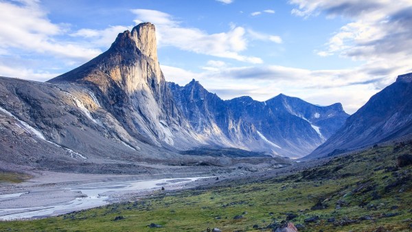
Mt. Thor is truly impressive. It pierces the sky at 1675 metres, which isn’t the impressive part. It has an unbelievable 1250-metre cliff face, which makes it the second-tallest vertical cliff face on Earth! Not only that, a good portion of this cliff face overhangs the valley by 15 degrees.
Cross the raging Half Hour Creek. You may have to explore a couple hundred metres of this unforgiving flow of water to find a place to cross. The creek has several smaller braids but after midday, the flow may be too high, and consequences grim, to cross the largest and final braid of the creek. Climb up the steep section of the creek – on top, the river braids just before it pours over the edge making a possible crossing that still may require needing the “tripod” technique again. Or you may simply have to wait it out.
Camp near the Thor Shelter.
Day 7. Thor Shelter to Crater Lake
Distance: 14.0km
Camp: On a large beach North of Crater Lake; 20W 387964 E 7375545 N, 60m
Significant River Crossings: Schwartzenbach River and Crater Lake Outflow
From Thor, it is only twenty-four kilometres and two more nights to the finish. Most of the major river crossings are behind you.
The last major milestone is crossing the Arctic Circle at 66°30’ N and a river section at Schwartzenbach Falls at around km 85 (53 mi). This part of the pass has an established hiker-made footbed. However, sections are washed out and massive moraines stretch into the valley, forcing you to choose your adventure route. There are some pretty waterfalls along this section of the trail, including Schwartzenbach Falls and an unnamed creek that cascades down the mountain in many separate waterfalls.
Camp on the north side of the Crater Lake on a beautiful sandy beach.
Day 8. Crater Lake to Ulu Shelter.
Distance: 8.7km
Camp: On a small knoll above the Ulu emergency shelter; 20W 388554 E, 7368025 N, 74m
Significant River Crossings: None
The last full day on the trail over moderate terrain to arrive at the UIu shelter. It is possible to climb the bluff directly above the shelter to set up camp and enjoy your last night from an elevated vantage point.
The Overlord and Ulu Peak shelters are no longer accessible.
Day 9. Ulu Shelter to Overlord. Boat Pangnirtung Fiord to Pangnirtung. Fly Pangnirtung to Ottawa.
Distance: 4.1km
Significant River Crossings: None
While it is possible to travel the 31 kilometres from the southern end of the park to Pangnirtung by foot along the fiord in summer, this has been likened to a 2-3 day slog and is not recommended. It is much easier during the winter when travelling on the sea ice. As a result, boat transportation at the end of the trip needs to be arranged.
Radio Parks Canada and outfitter to confirm your boat pick-up time and location from the emergency radios in the Thor and Ulu shelter. These may not work and depend on the outfitter checking his texts. Also, try using an inReach Mini to text the outfitter.
A satellite phone may be the ultimate method to get hold of the outfitter and confirm your pick-up.
Peter Kilabuk is one outfitter on the southern side of the pass. Pangnirtung is a thirty-five-kilometre boat ride. In Pang, stop at the Parks Canada office to let them know you are out of the pass.
Pangnirtung is a dry community of 1500 where the only restaurant is a KFC with a significantly reduced menu.
Flights
Pangnirtung (YXP) to Iqaluit – 15:55-16:55) Canadian North 1’ $832
Iqaluit (YFB) to Ottawa — 18:45-21:50) Canadian North 3’5” $828
9 full days. Starting and ending in Ottawa, this would be the minimum number of days to do 5 flights, 2 boat rides and walk 97kms. This avoids all hotel rooms except at Qik for one night. But it also gives little time to see Iqaluit and no safety days.
11 days. It would be best to give some safety days in case of bad weather and or delayed flights. Note that days four and five are both over 19 km, relatively long days.
An extra day at Summit Lake between days 5 and 6. If no delays, the last day could be in Iqaluit.
It is also possible to add as many days as desired to see the rest of Baffin Island: Iqaluit, Pond Inlet, and Cape Dorset (the epicentre of Inuit soapstone carving).
Mt Thor 
Mt Asgard
Pangnirtung
This hospitable hamlet is the southern gateway community to Auyuittuq National Park.
Also known as ‘Pangniqtuuq’ and fondly called ‘Pang’ for short, this artistic community, famous for the quality of its woven tapestries and lithographic prints, is situated on an ancient beach on the beautiful Pangnirtung Fiord at the north end of Cumberland Sound. It is located 50 kilometres (31 miles) south of the Arctic Circle. The scenic mountainous terrain is very popular with hikers, climbers and skiers. Visitors should drop by Pangnirtung’s Angmarlik Interpretive Centre and the Uqqurmiut Centre of the Arts to view their famous tapestries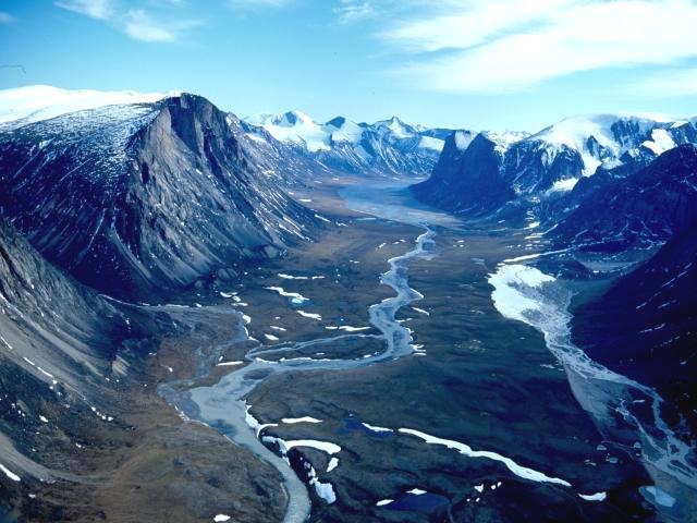
Pangnirtung Fiord
Timing. Generally, the skiing season begins around mid-March. It is usually possible to ski in Akshayuk Pass until early May when the Weasel River melts. Skiing into the park from Qikiqtarjuaq is not recommended — due to the high concentration of polar bears along the coast.
Sea ice and river conditions vary from year to year, affecting when the park is accessible and when certain activities are possible. Auyuittuq becomes inaccessible when the sea ice becomes unsafe for travel during break-up, usually in May or early June on the Pangnirtung side and a month later near Qikiqtarjuaq. Depending on the year, the park usually becomes accessible again by boat in late June or early July, which marks the start of the hiking season.
Due to summer flooding events each year since 2008, there may be closures between mid-July and early August if warm temperatures or rain cause glacial melt runoff that can make river crossings extremely hazardous. Although closures are possible at any time, high water levels have been most problematic between the last week of July and the first week of August and hiking then is not recommended.
Parks Canada advises visitors to call a week or two in advance to gauge whether they can arrive from the Qikiqtarjuaq side.
Safety. Auyuittuq is a backcountry park with little in the way of maintained facilities, apart from emergency shelters and outhouses. Despite its melting glaciers, Auyuittuq has a polar marine climate, which means winters are long and cold, while summers are short and cool. Even in summertime, snowfall is possible. While warm summer temperatures are common in July and August, hikers should be prepared at all times for inclement weather such as sudden drops in temperature, strong winds, and rain or snow.
Auyuittuq is also very windy, occasionally reaching gusts of 175 kph (109 mph)! Visitors must be prepared for all types of weather during their trip!
Visitors must be self-sufficient, as help is far away. Drowning, hypothermia and rock falls have injured and killed a few summer visitors.
Visitors must also be aware of the risks associated with polar bear encounters and know how to avoid them.
Orientation. All visitors to Auyuittuq National Park MUST register and attend a mandatory orientation session in either Qikiqtarjuaq or Pangnirtung prior to entering the park. It is also necessary to de-register with the park office upon exiting the park. Otherwise, a very costly search will be initiated.
Contact the park office in Pangnirtung in advance to book the mandatory orientation session with park staff. It is also necessary to read and familiarize oneself with our visitor information package before visiting the park.
Auyuittuq National Park
Pangnirtung Office
P.O. Box 353, Pangnirtung, Nunavut, Canada X0A 0R0
Phone: (867) 473-2500
Fax: (867) 473-8612
Email: [email protected]
Qikiqtarjuaq Office
P.O. Box 122, Qikiqtarjuaq, Nunavut, Canada X0A 0B0
Phone: (867) 927-8834
Fax: (867) 927-8454
Email: [email protected]
www.pc.gc.ca/eng/pn-np/nu/auyuittuq/index.aspx
Access fee: Park entry pass ($20/day or $120/season)
Weather forecast: Iqaluit
Flights. Most flights to Iqaluit originate in Ottawa. Canadian North has regularly scheduled flights to Pangnirtung. I tried to get Airmiles tickets but there were no flights available for any of these. Here are some example flights for the first 2 weeks of July 2020
Ottawa to Iqaluit (YFB) return (July 1– 07:15-10:25 – July 13–18:45-21:50) Canadian North 3’5” $828
Iqaluit to Pangnirtung (YXP) return (July 1 – 12:00-13:00 – July 13 – 15:55-16:55) Canadian North 1’ $832
Pangnirtung to Qikiqtarjuaq (YVM) one-way (July 1 – 13:30-14:12) Canadian North 42” $261.
Time Line
July 1. Fly Ottawa to Pangnirtung to Qikiqtarjuaq. Orientation Parks in Qikiqtarjuaq in the afternoon. Camp or hotel Qikiqtarjuaq.
July 2. Start Trip. 82 km boat to start of trail. Start hiking (at least 3 hours from the coast to avoid bears). Camp Owl River
July 3-10 (9 full days). A complete trip through pass + flight to Iqaluit. Most do the backpacking part in 8 days. Could have 1 or 2 full days at Summit Lake, a good basecamp to explore the park. Gives some safety days in case of bad weather.
July 10 or 11. Early boat back to Pangnirtung.
July 11. Flight Pangnirtung to Iqaluit at 15:55. Overnight in Iqaluit.
July 12. Flight Iqaluit to Ottawa at 18:45.
Note that with these flights, there are no hotel costs in Pangnirtung. Camp or hotel in Qikiqtarjuaq on the first night. Decide if you want a day in Iqaluit at the end.
Guides/Outfitters for the boat trips at the beginning and end.
Billy Arnaquq (867 927-8834). Qikiqtarjuaq outfitter. Eighty-five-kilometre journey down the North Pang Fiord.
Peter Kilabuk (867 473-2500). Pangnirtung outfitter on the southern side of the pass.
Examples of Tour Operators and costs
Inukpak Outfitters in Iqaluit offers an 11-day backpacking trip plus a day in a hotel at each end for $7,695 + 5% GST per person for double occupancy. Their trips run the first two weeks of August.
Great Canadian Trails offers 5-nights camping + 2 days in hotels (the out and back trip) for $3299.
Kekerten Island Territorial Park where an Inuit guide will show you around the island’s old whaling station and its carefully-preserved artifacts from the late 19th century. This guided tour will take you through a part of history that is kept alive by a just a few elders in the nearby community.
Return trip from Overlord to Summit Lake on the Pangnirtung side of the park and back. This six-day return trip to Summit Lake and back is the most common trip and the one offered by Black Feather, the main company offering guided trips. Summit Lake is also a great place to set up a base camp for day hikes.
For those with less time, day or overnight hikes to the Arctic Circle are possible from Pangnirtung.
GROUP GEAR
Cooking & Eating
MSR Dragonfly stove
MSR Fuel – 30 oz bottle
GSI aluminum pots (2) with fry pan and heat diffuser
MSR Stove repair kit
Water carrier (collapsible nylon)
Camp
MSR Hubba Hubba NX Tent
Siltarp 8’x10′
Other
Goal Zero solar charger* – one between group
Zip ties
Tenacious tape, Sewing awl
Leatherman
Clothes washing powder (I plan on washing every night and hanging from pack. Only 2 of everything)
Safety & Navigation
First aid kit (individual?)
Waterproof matches
Akshayuk Pass map
Garmin inReach Mini
Cell phones* sat phone?
PERSONAL GEAR
Clothing
Marmot rain/wind shell jacket
Nylon rain pants
Zip-off leg hiking pants/shorts
long merino underwear
Mountaineering boots. Altra Lone Peak 4 Mid REM
Puff down jacket
Short gaiters
Touque
Buff
Hat
Gloves + pile overmitt
Water shoes + neoprene socks? also my “camp shoes” with light socks
Long sleeve zip Ts 2 or 3
Fleece mid layer
Marmot Driclime jacket
Vest
2 boxers
2 pair liner + thick wool/nylon blend socks
Sunglasses and strap
bandanas (washcloth, sweatband, towel)
Other
Deuter 60 + 10 L pack
Kindle Paperwhite (backlit for night reading)
Western Mountaineering -7 down sleeping bag
Thermarest sleeping mat
Inflatable butt pad
Phone camera??
Headlamp??? 24-hr light
Day pack?? – Camp extralight (minimalist with no padding, we are doing no or maybe one day hike from Summit Lake)
Soap – powder soap for clothes, dishwashing soap, small bar.
Toilet paper roll, small spade for rabbit holes, lighter to burn toilet paper
Hand sanitizer??
Black Diamond hiking poles
FOOD & DRINK
Water bladder inside pack
Water bottle? Collapsible water carrier for camp
Bowl
Spork, serrated knife
Mug
Breakfast: granola, milk powder, coffee, sugar
Lunch: Hummus & veggies for first 1-2 days. Dry crackers, cream cheese, salami, mustard, mayo, dense bread, peanut butter, Nutella, cheese
Dinners: homemade dehydrated: Bean Hot Pot (dehydrated mashed potato), Pasta sauce (thin spaghetti), powdered soups.
Energy drink Mix
Snacks, bars, trail mix, jerky, etc. dried fruit,
NOTE: We would have no technical gear as not climbing the glacier. Make every attempt to be as light as possible. I don’t plan on carrying over 30 lbs. Share tent and cooking gear with groups of two. Clothing one change of everything. Use an antiperspirant like Drysol to avoid the need to bathe. Make all my own dehydrated meals (I would be happy to share the recipes).
Their Gear
Water filters not necessary (drink this water straight from the creek/river, even with glacial silt)
Stoves: Need to discuss – at least one good stove per 2 people plus a canister stove or two. 3 – 1l fuel bottles per stove. I have an MSR Dragonfly with its own large stove repair kit.
Siltarp (I have an 8×10 and 10×10 siltarp – wind issues)
Communication: Sat phone sounds ideal. inReach? Need to be able to call the boat at Pangnirtung.
Gear for Group Traveling on Glacier. They started with 75lb packs and estimated that by the end they were about 60 lbs.
*stuff I would not bring
GROUP GEAR
Cooking
MSR XL Autoflow water filter*
MSR Whisperlite stove
MSR Fuel – 30 oz bottle
MSR stainless steel pot
MSR Stove repair kit*
Flasks
Camp
Nemo Losi 3p Tent
Rab Siltarp 10’x10′*
Other
Zip ties
Tenacious tape
Sunscreen
Bug repellant
Leatherman
Safety & Navigation
Beofeng radios*
First aid kit
SOL Emergency Bivvy*
Waterproof matches
Akshayuk Pass map
Garmin inReach Mini
Cell phones*
Technical Gear*
Beal 45m half rope
Petzl ice screws
Petzl PMPs
Black Diamond webbing
Black Diamond slings
Black Diamond nuts
Camp tri-cams
Black Diamond crampons
Black Diamond ice axe
Mammut Zephir Altitude harness
Mammut Wall Rider MIPS helmet
Carabiners
Prussiks
PERSONAL GEAR
Clothing
Mammut GTX jacket
Mont-Bell rain pants
Arc’teryx softshell pants
Scarpa mountaineering boots
Arc’teryx down jacket
Black Diamond gaiters
Buff touque
Buff neck tube
Arc’teryx hat
Petzl gloves
Solomon water shoes
T-shirts*
Long-sleeve shirt*
Shorts (zip off legs)
Mammut fleece hoody/mid layer
Saxx boxers
Wool socks
Down booties*
Sunglasses and strap
Camp towel
Camp
Mammut Trion Spine 75 L pack
Marmot 0C down sleeping bag
Thermarest Neoair sleeping mat
Foam butt pad
Other
Phone case/bag*
Camera*
Petzl Actik headlamp*
20L Arc’teryx summit pack*
Goal Zero solar charger*
Soap
Toilet paper roll”
Hand sanitizer
Black Diamond hiking poles
Food & Drink
Water bottle
Bowl
Spork
Mug
Oat mix, breakfasts
Dried dinner
Energy drink Mix
Snacks, bars, trail mix, jerky, etc.
