
Iraq – Kurdistan (Erbil, Suleymaniyeh, Dohuk) December 9-10, 2019
Currency. Iraq Dinar (IQD). Exchange rates (December 2019). 1US$ = 1200 IQD.
1 € = 1,316 IQD. There is no black market for the Iraq Dinar.
Diesel. At 600 IQD/litre this is the second cheapest in the Middle East at $US .50/L or € .46/l. Diesel is cheaper than gasoline. It is dispensed at pumps removed from the normal gas pumps and uses a large diameter filling tube made for large trucks that makes it difficult for my van.
Google Maps. Navigation is not available in Iraq. With only preview, you set your destination and get a route but nothing else. It is an interesting way to travel with no turns, scale change, rerouting, distances or time. The only other place I have been like this is Kosovo.
Alphabet. Arabic. Truly impossible to understand. They write from the right. Road signs and most businesses also are in Latin script.
GETTING IN
Visa. Visa on arrival at the Turkey/Kurdistan border at Ibrahim Khalil border crossing, for practical purposes, the only border crossing between the two countries, and the only one it is possible to bring a European registered vehicle into Iraq.
Turkey immigration for once was quick. But Kurdistan was an interminable mess. Getting a stamp on my passport was easy. Then I had to have a paper that my van had passed a certain point. I needed the “list”, a paper that lists my name, passport number, DOB and destination. Then all the details of the car including the chassis number, that it was diesel, 4-cylinder, on and on.
Then the car had to be cleared to enter. My car is registered under My California in Belgium but I have a letter from My California that I am the owner of the vehicle (this has been a crucial piece of paper to have). They wanted to know where in Belgium it is registered – the first time I have been asked this in over 50 border crossings. They pondered this problem for 30 minutes before deciding that I owned the car.
They wanted to keep my passport (since 2009, necessary because of terrorists). I objected so we walked to a building 200m away to talk to a guy behind a big desk and I was given permission to keep it.
Then one must pay IQD10,000 (about US$9) as some sort of tax (entry? road tas? and they only accept IQD. I went to a bank and for some reason, he wanted to change US$25 and I probably got a poor exchange rate. Pay the tax and then return it to the undeciders. Get a piece of paper that says you have paid the tax and a “vehicle passport”. Then everything is checked twice again. OMG!
I got so flustered that I forgot to get vehicle insurance.
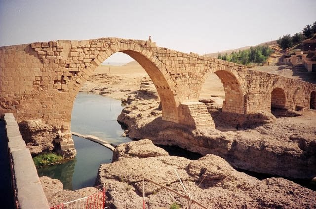
Delal Bridge. In Zakho, just across the border, this is an ancient, gorgeous yellow stone bridge crossing the Khapour River that has 5 arches. It is 114m long, 4.7m wide, and 16m high and was built using large river stones.
Because of a shortage of official documentation, the history of Pira Delal can be told only in speculative terms. Ancient Romans are credited with constructing of the first bridge that stretched across the river, but the current structure is not of Ancient Roman origins. It is, in fact, much more likely that the bridge in its current form dates back to the early years of the Abbasid dynasty (750-1517).
As with many ancient sites in Northern Iraq, it goes by several names, including Delal Bridge, Zakho Bridge, Pira Delal, Pirdí Delal, and Pira Berî. This is partly due to lexicographical changes through time, the co-existence of different language-speaking peoples, and formal versus informal registers.
Local stones found in and around the Khabur River were used to construct the bridge. Their large size, however, has fueled a flurry of more or less plausible theories as to how they might have been deployed in ancient times. A rather grisly legend has it that the hands of the ingenious craftsman who built the bridge were amputated to prevent him from constructing another bridge that could compare to Pira Delal. Furthermore, one of the craftsman’s nieces is said to be buried under the bridge as a sacrificial offering.
Today, even though there are newer, sturdier bridges that cross the Khabur River, this bridge still sees a fair amount of pedestrian, cyclist, and motorcyclist traffic. It’s also a hotspot for daredevils, who dive from its apex into the tiny pools that seasonally form at the foot of the bridge.
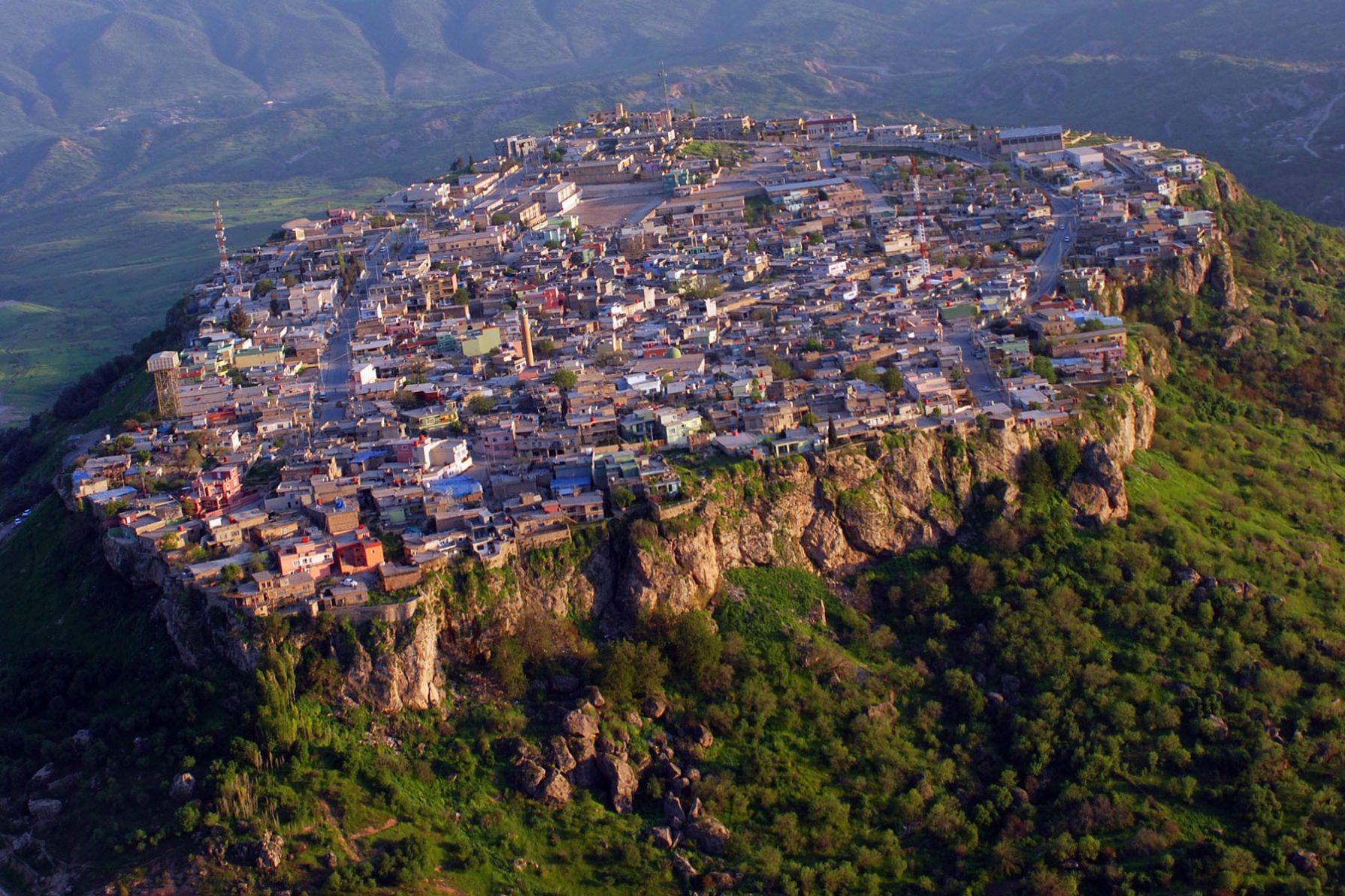
AMEDY CITY. (02/02/2011)
Amadiya (Kurdish: Amêdî) is an Iraqi Kurdish town and popular summer resort and Hill station along a tributary to the Great Zab. The city is situated 4,600 feet (1,400 m) above sea level.
History. Due to its strategic place on the flat top of a mountain surrounded by steep cliffs, it was an Assyrian city known as Amedi from the 25th century BC until the end of the 7th century BC, then part of Achaemenid Assyria, Seleucid Assyria and Parthian and Sassanid-ruled Assyria until its conquest in the mid 7th century AD by the Arabs. Then, for several centuries, it was ruled by a pasha from the wealthy Abbas family.
The region is believed to be the home of some of the most significant Magi priests: the Biblical Magi or the “Three Wise Men” who made a pilgrimage to Bethlehem to see Jesus Christ shortly after his birth.
In 1163, the Jewish population numbered about a thousand families and traded in gall-nuts and was wealthy and contented. A place where Muslims and Christians coexisted peacefully for centuries, it has a present-day population of approximately 5,000 and was also home to a sizeable Jewish community before the State of Israel was created in the late 1940s. Present-day Amedi still has a well-integrated Assyrian-Christian and Muslim Kurdish community with physical remnants of its Muslim, Christian, and Jewish history throughout the village.
Amadiya was the seat of the semi-autonomous Badinan Emirate, which lasted from 1376 to 1843. At the turn of the 19th century, the population numbered 6,000, of whom 2,500 were Kurds, 1,900 Jews and 1,600 Assyrians. There are ruins from the Assyrian era and ruins of a synagogue and a tomb attributed to Ezekiel and a church.
Geography. The town is perched on a mesa or a plateau 1,000m long and 500 m wide, formerly only accessible by a narrow stairway cut into the rock. Amadiya has a well-integrated community of Assyrian Christians, Jews and Muslim Kurds who share the city and local social events.
Although Amadiya is just 16.9 km from the Turkish border across the Beshesh Mountains, the only border crossing into Turkey is now at Ibrahim Khalil 90 km away.
It has 6,000 citizens in almost 1,200 houses.
Climate. Amadiya has a hot summer with long, hot summers and cool, wet winters. Being the most northerly city in Iraq, it is the mildest major city in the country.
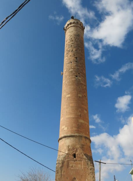
Great Mosque of Amadiya (Sulaymaniyah Great Mosque). One of the icons of the city, the 33m high minaret dates to the 12th century and is the oldest and largest in Kurdistan. It is a very impressive yellow stone structure. Inside, a spiral staircase leads to the top of the minaret where the Adhan, or call to prayer, is traditionally performed five times daily.
Visitors are also allowed to enter the minaret for a view of the village and valleys below when the caretaker or imam is available. The Amedi minaret has been compared to the one that once towered over the Mosul’s al-Nuri mosque, which was destroyed by ISIS in 2017. They were built during the same period and have a similar round tower on a square foundation.
Formerly used as a church, the mosque was later founded in the 16th century during the reign of Sultan Hussein Wali (1534-1570 C.E.), prince of the Bahdinan Emirate, one of the most powerful Muslim Kurdish principalities in history.
The architectural design of the structure itself, with the floor sitting over a meter below ground level, hints that the present-day mosque may have once been used as a temple prior to being converted into a church. The mosque, with an area of approximately 2,000 square meters that can accommodate at least 300 worshipers, was also once used as a school for Islamic studies and Arabic language. The inside is quite unusual with 4 sections separated by massive arches and raised benches.
It was locked when I arrived. Two university students arrived and opened it (the key is under the carpet). They were studying English and took me to a tea shop down the street. They asked me to stay with them at the dormitory and I foolishly declined. They were very pleasant and became Facebook friends.
We learned that Iraqis can only go to 27 countries with their passport. Only North Korea is probably worse.
I then drove to Erbil via Dohuk where I went to a Western Union and exchanged money and spent the night. It was a long drive as the road I took had a lot of construction and a lot of it was narrow 2-land.
ERBIL (pop 879,000, 2,009 in the urban area)
Erbil (Kurdish Arbela Syriac), known in ancient history as Arbela and also spelled Arbil, Arbel and Irbil, is the largest most populated city in Iraqi Kurdistan and capital city of the Kurdistan Region. It is located approximately in the center of Iraqi Kurdistan region
The city has an ethnically diverse population of Kurds (the majority ethnic group), Assyrians, Turkmens, Arabs, Yazidis, Shabaks, Mandaeans and Armenians. It is equally religiously diverse, with believers of Sunni Islam, Shia Islam, Christianity, Yasanism, Shabakism and Mandaeism extant in and around Erbil.
History
Human settlement at Erbil may be dated back to the 5th millennium BC, which would make the city one of the oldest continuously inhabited areas in the world. I was largely under Sumerian domination from c. 3000 BC, until the rise of the Akkadian Empire (2335–2154 BC) which united all of the Akkadian Semites and Sumerians of Mesopotamia under one rule. Today the Assyrian people, a Syriac-speaking community endure as a minority in northern Iraq, northeast Syria, southeast Turkey and northwest Iran, their population is estimated to be 3.3 million.
Erbil became an integral part of the kingdom of Assyria by the 21st century BC through to the end of the seventh century BC, after it was captured by the Gutians. After this, it was under several empires: the Median Empire, the Achaemenid Empire (Persian emperor Cyrus the Great occupied Assyria in 547 BC), Macedonian Empire (Alexander the Great defeated Darius III of Persia in 331 BC, took place approximately 100kms west of Erbil), Seleucid Empire, Parthian Empire, Roman Assyria and Sasanian Empire until the first half of the 7th century. Its populace gradually converted from the Mesopotamian religion between the 1st and 4th centuries to the Chaldean Catholic Church Christianity.
Following the Muslim conquest of Persia, it no longer remained a unitary region, and during the Middle Ages, the city had a gradual influx of Muslim peoples, predominantly Arabs, Kurds and Turkic peoples and came to be ruled by the Seljuk and Ottoman empires..
The most notable Kurdish tribe in the region was the Hadhbani and it was mostly Kurdish-populated in the 13th century.
When the Mongols attacked Arbil for the first time in 1237, they plundered the lower town but had to retreat and put off the capture of the citadel. In 1258, the Mongols returned and captured the citadel after a siege lasting six months. Hülegü then appointed an Assyrian Christian governor to the town. Sustained persecutions of Christians, Jews and Buddhists began in 1295 and the Assyrian inhabitants retreated to the citadel to escape persecution. The citadel was at last taken after a siege by Kurdish tribesmen in 1310, and all the defenders were massacred, including many of the Assyrian inhabitants of the lower town. However, the city’s Assyrian population remained numerically significant until the destruction of the city by the forces of Timur in 1397.
Erbil was the birthplace of the famous 12th and 13th-century Kurdish historians and writers Ibn Khallikan and Ibn al-Mustawfi. Erbil and all of Iraq passed into the hands of the Ottoman Turks in the 16th century. Erbil was part of the Musul Vilayet in the Ottoman Empire for 400 years until World War I, when the Ottomans and their Kurdish and Turcoman allies were defeated by the British Empire.
The modern town of Erbil stands on a tell topped by an Ottoman fort. During the Middle Ages, Erbil became a major trading center on the route between Baghdad and Mosul, a role which it still plays today with important road links to the outside world.
Today, Erbil is both multi-ethnic and multi-religious, with the Kurds forming the largest ethnic group and smaller numbers of Arabs, Assyrians, Turcoman, Armenians, Yazidis, Shabaks, Circassians, Kawliya, Iranians and Mandeans
The parliament of the Kurdistan Autonomous Region was established in Erbil in 1970 after negotiations between the Iraqi government and the Kurdistan Democratic Party (KDP) but was effectively controlled by Saddam Hussein until the Kurdish uprising at the end of the 1991 Gulf War. The legislature ceased to function in the mid-1990s when fighting broke out between the two main Kurdish factions, the Kurdistan Democratic Party and the Patriotic Union of Kurdistan (PUK). The city was captured by the KDP in 1996 with the assistance of the Iraqi government. The PUK then established an alternative Kurdish government in Sulaimaniyah.
The Kurdish Parliament in Erbil reconvened after a peace agreement was signed between the Kurdish parties in 1997, but had no real power with control only in the western and northern parts of the autonomous region.
During the coalition forces’ occupation of Iraq, sporadic attacks hit Erbil. Parallel bomb attacks by the Ansar al-Sunnah against Eid celebrations killed 109 people in 2004. A suicide bombing on 4 May 2005 killed 60 civilians and injured 150 more outside a police recruiting centre.
In 2015, the Assyrian Church of the East moved its seat from Chicago to Erbil.
Erbil is not an attractive city nor does it have much to see. There is no outstanding architecture and is a flat plain surrounding the citadel.
Transportation. Erbil International Airport opened in 2005 has international flights from the Netherlands, Germany, Saudi Arabia, Austria, Turkey, and Jordan. Erbil has a system of five ring roads encircling the city.
Climate. Erbil has a Mediterranean climate with long, extremely hot and dry summers and mild winters. Winters are rainy.
Citadel of Erbil. This is an occupied mound in the historical heart of Erbil, standing 25-32m above the surrounding plain. The buildings cover a roughly oval area of 430 by 340m. It has been claimed that the site is the oldest continuously inhabited town in the world. The earliest evidence for the occupation of the citadel mound dates to the 5th millennium BC and gained importance during the Neo-Assyrian Empire (10th to 7th centuries BC) period. During the Sassanian period and the Abbasid Caliphate, Erbil was an important centre for Assyrian Christianity and the Assyrians. After the Mongols captured the citadel in 1258, Erbil’s importance began to decline.
During the 20th century, several houses and public buildings were destroyed. In 2007, all inhabitants, except one family, were evicted from the citadel as part of a large restoration project.
The only religious structure that currently survives in the citadel is the Mulla Afandi Mosque (closed for renovation). When it was fully occupied, its three districts were Serai (notable families), the Takya (named after the homes of dervishes) and the Topkhana (craftsmen and farmers). Other sights include the 1775 hammam, also closed) and the Textile Museum. Erbil citadel has been inscribed on the World Heritage List in 2014.
To see the citadel, it is necessary to park at the bottom and walk up the cobbled road. I entered at the Ahmadi Gate and walked across the one street past the mosque and closed hammam to the Grand Gate where the textile museum is. This is not an impressive place – mostly newer brick buildings and ruins with muddy streets and no people. Other museums are the Miniature Kurdish Costumes, Erbel Gems and Stones Museum and Traditional Kurdish Costume Museum.
Kurdish Textile Museum. The textiles are nomad carpets, kilims saddle bags and baby carriers. It is more of an ethnography museum with costumes, a kitchen, agricultural, skull caps and jewelry displays.
There are 20 semi-nomadic and 4 nomadic tribes in Kurdistan, each originally with 100-1000 families. They spend from late spring to September in the mountains with their herds and living in black tents. Most of the nomadic way of life ended in the 1980s when they were confined to Iraq and lost much of their traditional grazing land in Iran and Turkey. Turkish air strikes and landmines didn’t help. They are no longer self-sustaining.
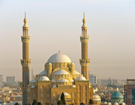
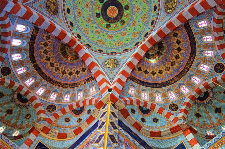
Jalil Khayat Mosque. This new mosque has 2 minarets each with 3 balconies. The outside has great tiles even the small round columns on the porch. It was locked but after the “boss” (an ancient man) arrived, they opened it so that I could see the inside. It is a wonder of domes and gorgeous tile work with red/white arches
. Surrounding the main dome are four half domes and another 4 cascading down. The mihrab is mirrored stalactites.


Erbil Bazaar (Grand Bazaar). A traditional souq, all domes and little shops were you can buy anything from soup to nuts.
After Erbil, I only wanted to go back to Turkey for several reasons. I had no Iraq vehicle insurance and didn’t want to stay any longer than I had to. To see anything else required long drives. There was not much of interest to see anyway. I was tired of Kurdistan drivers.
On the way back, I took the wrong turn (a Google Maps error) and started towards Mosul which caused a big hassle at the next military checkpoint. I had to return about 10kms. I ended up driving on a much better road than I came on with no road construction but a lot of trucks and aggressive driving.
To cap it all off, my engine check light came on. I could not find a VW dealer in Dohuk, so continued to the border. I filled up with diesel just before the border. The attendant also exchanged by IQD for Turkish lira (I have no idea if I got ripped off or not, but it sure saved a lot of time).
GETTING OUT
Park and go into Passport Control. With a vehicle, present the “list”, a paper that lists your name, passport number and car license #. Get a stamp in your passport.
Check the list and passport.
Hand in the “vehicle passport” and pay 10,000 IQD. I have no idea what this is for – road tax? entry tax? but I also had to pay it on entry. They accept only IQD so you need to go to the bank that is nearby and exchange $US. The first time he demanded $25 and gave me some change back, probably incorrect in retrospect 10,000IQD is about US$9. This time, the only $US I had was a $100 bill and he shortchanged me by $10, I complained and he gave me the right change). Get a receipt.
Hand in the receipt. Check the car and get another piece of paper.
Hand in that piece of paper.
Hand in the “list” and get your passport scanned.
Each of these steps being in a long line of cars. No one speaks English. It can drive you nuts.
Then deal with Turkey immigration where they check the same things 3 times.
I didn’t go here but I include it for completeness’s sake.
SULAYMANIYAH is surrounded by the Azmer Range, Goyija Range and the Qaiwan Range in the northeast of Kurdistan. Baranan Mountain in the south and the Tasluja Hills in the west. The modern city was founded in 1784 by the Kurdish prince Ibrahim Pasha Baban who named it after his father Sulaiman Pasha and served as the capital of Baban from 1784 to 1850.
From its foundation, Sulaymaniyah was always a center of great poets, writers, historians, politicians, scholars and singers, such as Nalî, Mahwi, and Piramerd.
The city is known as the capital of enlightenment among the Kurds, but the official nickname nationally level is the Paris of Iraq or the bride of Iraq’s cities.
History. It dates back to the Old Babylonian Period.
The capital of the Kurdish Baban principality (1649–1850), before Sulaymaniyah was a territory named “Qelaçiwalan”. At the time of the Babani’s rule, there were major conflicts between the Safavid dynasty and the Ottoman Empire. Qelaçiwalan became a battleground for the two rivals.
Being of strategic importance and lying deep inside Safavid territory, Mahmud Pasha of Baban in 1781 moved the capital to Melkendî, then a village but now a district in central Sulaymaniyah. In 1783, Ibrahim Pasha of Baban became ruler of the Emirate and began the construction of a new city to become the capital of the Baban Emirate. In 1784 he finished erecting many palaces for trade called Qeyserîs and bazaars, which were also used as baths, and began inviting people from the surrounding villages and Emirates to move to the newly established city. Soon Melkendî became one of its quarters and still is today. The new city of Sulaymaniyah was named after Sulaiman Baba who was the first Baban prince to gain control of the province of Shahrizor and its capital, Kirkuk. Sulaiman Baba invaded Iran, defeating forces in 1694.
From 1922 to 1924, Sulaymaniyah was the capital of the Kingdom of Kurdistan, a short-lived unrecognized State declared by Iraqi Kurds following the collapse of the Ottoman Empire.
Demographics.
In 1820, the population was more than ten thousand, containing 2,144 families of which 2,000 were Muslim, 130 Jewish, and 14 Christian.
In 1907 there were 8,702 Muslim and 360 non-Muslim residents and in 2015 to 656,100
Climate. Classified as a hot-summer Mediterranean climate characterized by cooler summer temperatures and its rainier winters. Average temperatures range from 0 to 39 °C. Snow is not frequent in winter.
Education. The University of Sulaymaniyah was opened in 1968 and is the largest university in the Kurdistan Region of Iraq.
Culture. Sulaymaniyah is considered the center of the Sorani Kurdish culture in Kurdistan and the cultural capital of South Kurdistan. Development of Sorani as a modern literary language started in this city in the early 19th century, when many Kurdish poets such as Nalî, Piramerd, Muhamed Amin Zaki, Abdulla Goran, Muhamad Salih Dilan, Ahmad Hardi, Ibrahim Ahmad, Nuri Sheikh Salih Sheikh Ghani Barzinji, Sherko Bekas, and Bachtyar Ali published their works.
The city is known for its open, relatively liberal and tolerant society when compared to other cities of Kurdistan. Chinatown has 500 Chinese residents.
Economy. Since 2003 Iraq has seen a huge economic boom with tourism and agriculture are the main businesses here. The city was visited by more than 60,000 tourists in 2009, especially Iranians drawn by the fact it is not subject to strict laws faced at home.
Sulaimani Museum: It is the second biggest museum after the national museum in Baghdad. It is home to many Kurdish and ancient Persian artifacts dating back to 1792–1750 BC.
I also didn’t go here but it was recommended.
HAMILTON ROAD
This road dates back to 1928, when the British, who took control of Iraq following the fall of the Ottoman Empire, brought in Archibald Hamilton to design a road through the mountainous terrain to the Iranian border. Not only was it a strategic route but the mere fact that this road exists through such dramatic scenery is really an engineering marvel.
Choose to take the lower road through a canyon along the river with dramatic scenery. Gali Ali Bag is the tallest waterfall in the Middle East and is on the back of Iraq’s 5,000 Dinar note!
The upper road travels along the rim of the canyon with great scenery with the walls of the canyon soar up from the rim
After both roads wind their way through the canyon, you pass through the Kurdish towns of Rawanduz and Soran before continuing towards the border with Iran. The majestic peaks of northern Iraq lay before you.
