
Turkey – Northeast, Central-East Anatolia (Erzurum, Kars, Van, Malatya) December 4-6, 2019
I entered the far north of this area from Georgia. Turkish immigration was the usual bureaucratic nightmare where they check the same documents 3 times. With a great improvement in roads I drove about 50kms and slept. It was -3°C when I went to sleep and -11°C under clear skies when I got up. The heater in the van keeps me very cozy and I worked online till 1am.
With about 2-3cms of snow on the ground the roads had some hard packed snow but were plowed and well sanded. The road circumnavigated the large Lake Çildir 40kms north of Kars, the snow was just a skiff and the roads completely clear allowing high speeds for the first time in a while.
The road descended off the high plateau into a valley full of bentonite hills – soft clay-like dirt often layered in colours (the best are the Danxi in China and in southern Utah around the Paria Movie Set).
KARS
Kars Museum. This good museum gave an excellent history of all the Ages of Man with artefacts from all over Anatolia to demonstrate them. Many pieces were from Ani. The yard had several gravestones especially ones in the shape of rams and fish. Free
Kars Castle. Built in 1183, destroyed by the Mongols and rebuilt in 1539, it sits high on the hill, with intact walls, a functioning mosque and a large keep and fortified inner castle. Free
ARCHAEOLOGICAL SITE of ANI
Situated 42 km from Kars on the eastern border of Turkey with Armenia across the Akhurian River, a stunning ravine that shapes the natural border between Turkey and Armenia. The once-great metropolis was situated on several trade routes, grew to become a walled city of more than 100,000 residents by the 11th century, and was a contemporary of the Middle East’s most powerful cities of Constantinople, Baghdad, and Cairo. At its height, the city became known as the City of Forty Gates and the City of a Thousand Churches. Ani’s Armenian rulers and city merchants funded an extraordinary number of places of worship, all designed by the greatest architectural and artistic minds in their milieu. Although the nickname was hyperbole, archaeologists have discovered evidence of at least 40 churches, chapels and mausoleums to date.
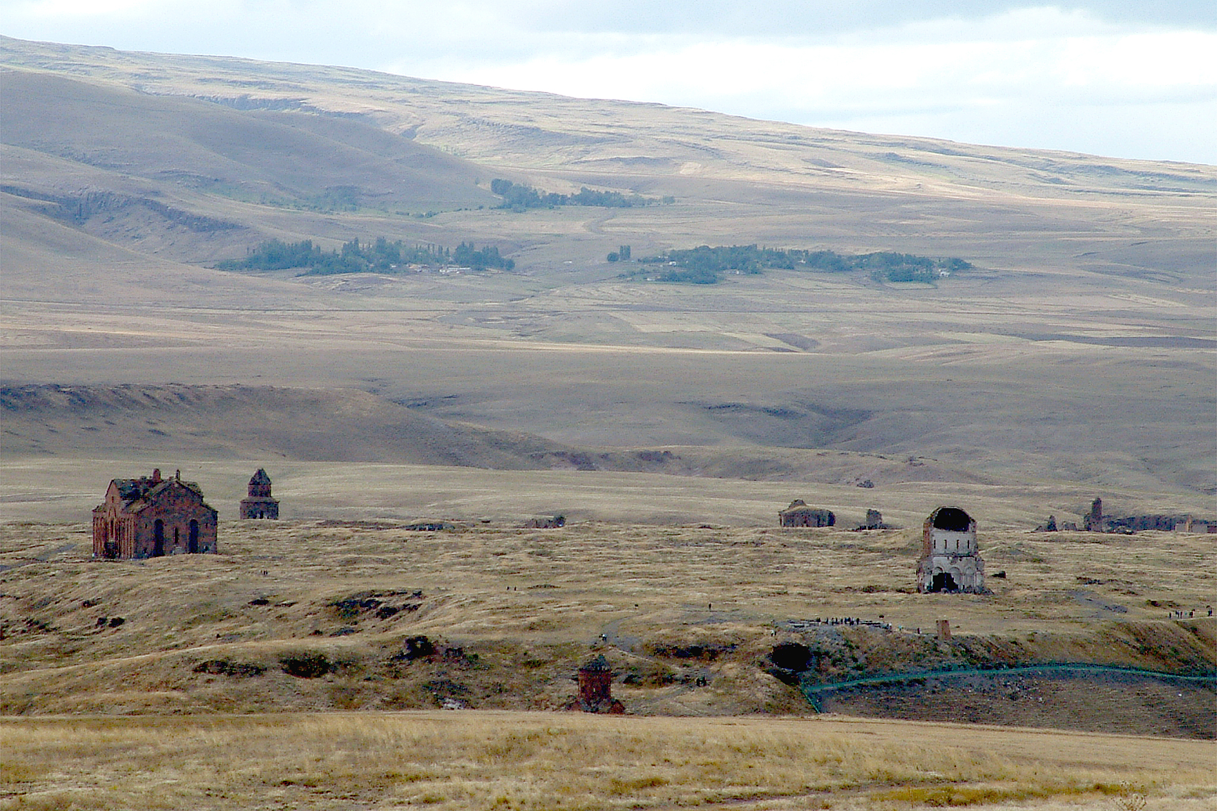
It is literally in the middle of nowhere on a secluded plateau. Apart from the beautiful natural scenery, the empty, crumbling structures themselves are exceptional, including the ruins of a stunning cathedral and six churches. It fell to a succession of invaders contributing to the ruin’s slow demise, aided by deterioration over time, earthquakes, war, and vandalism.
History. The history of Ani dates back to 5,000 B.C. to the Chalcolithic period.
Ani’s first rise to prominence was in the 400s AD. At this time, it was a hilltop fortress that belonged to the Armenian Kamsarakan Dynasty; by the 800s, however, the Kamsarakan possessions in Eastern Anatolia had merged with the Bagratid Dynasty. In 956, King Ashot III of the Bagratid Kingdom of Armenia moved the Armenian capital to Ani, and Armenian Catholics followed. It remained the capital until 1045.
The city of Ani prospered as the undisputed center of Armenia in the tenth and eleventh centuries flourishing as a branch of the Silk Road with more than 100,000 citizens controlling the greater area of what is today northeast Turkey and Armenia.
However, following the death of King Gagik in 1020, Armenian power was split between two sons and the golden age ended. The son who controlled Ani, attempting to prevent invasion, named the Byzantine Emperor his heir. The new king of Ani tried to keep his city independent, but after three years of military defeats and a pro-Byzantine uprising, Ani surrendered and the Byzantines established control.
The city of Ani survived for another 650 years, but it was now a provincial town at the edge of competing empires. In 1064 the Seljuk Turks took the city and massacred the populace. The Seljuks passed possession to Kurdish Shaddadids who were conquered in 1199 by Queen Tamar of Georgia, and the Zakarid Dynasty of Ani was established. The city prospered once again but was devastated this time in 1236 by the invading Mongol Hordes. The city was damaged by an earthquake in 1319. After the death of Timur who captured Ani in the 1380s, the Persian Safavids regained control, but they transferred their capital to Yerevan. They ruled Ani as the vassals of various Turkic and Persian Empires until it became a part of the Ottoman Empire in 1579.
The site of Ani was totally abandoned by 1735 when the last monks left the monastery in the Virgin’s Fortress. In 1878, Kars region was incorporated into the Russian Empire. Rediscovered and romanticized in the 19th century, the city had a brief moment of fame, only to be closed off by World War I, and with the 1921 treaty of Kars Ani became a part of the land of the Republic of Turkey. Later events of the Armenian Genocide left the region an empty, militarized no man’s land. After. The ruins crumbled at the hands of many: looters, vandals, Turks who tried to eliminate Armenian history from the area, clumsy archaeological digs, well-intentioned people who made poor attempts at restoration, and Mother Nature herself.
Despite the corrosive effects of time and human interaction, the ruins of Ani continue to fascinate travelers, an eerie, abandoned city of ruins spanning three centuries and five empires.
It wasn’t until the first half of the 19th century that European travelers happened upon the ruins of Ani and began to write about their impressions in academic journals and travel accounts. In 1878, Ani as part of the Russian Empire’s Transcaucasian region, the first archaeological excavations took place by the St. Petersburg Academy of Sciences. During WWI, when Ottoman armies captured Kars in 1918, the Russian-led archaeologists did what they could to salvage the remains of the ancient city and fled to modern-day Armenia and they continue to be on display at the Yerevan State Museum of Armenian History. During the Turkish War of Independence, Turkey ordered that the “monument of Ani be wiped off the face of the earth.” The commander did not obey, fortunately, so the monuments of Ani remain. On the other hand, however, Russian excavations and repairs were undone, and the site languished under what can be most favorably described as neglect. Sadly, the remaining artifacts were either looted or destroyed, leaving Ani in the dilapidated state in which it continues to live today.
Despite Ani’s history as a field of warfare, the ruins also represent many periods throughout history where the city saw a remarkable interchange of cultures, religions and artistic motifs.
Cathedral of Ani (Surp Asdvadzadzin), Construction of the structure began in 989, completed in either 1001 or 1010 under the reign of Armenian King Gagik I, when the wealth and population of Ani were at its peak. Trdat, the renowned Armenian architect who designed it, also served the Byzantines by helping them repair the dome of the Hagia Sophia. Its Gothic architecture is a style that the Ani cathedral predates by several centuries. Designed as a domed cruciform church, both the dome and the drum supporting it collapsed in an earthquake in 1319. Centuries later, another earthquake destroyed its northwest corner – it is still imposing in scale with its rust-coloured brick Turkey launched a project to conserve the ancient cathedral and a church in what is seen as a gesture of reconciliation toward neighboring Armenia.


Surp Stephanos Church. Possibly dating from 1218, it was referred to as “Georgian”, not ethnic Georgian, but a denominational meaning for all those in Ani who professed the Chalcedonian faith, mostly Armenians.
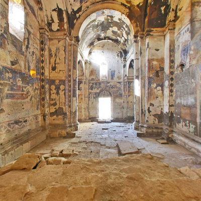
The Church of St Gregory of Tigran Honents. Paid for by the wealthy Armenian merchant Tigran Honents and finished in 1215 when the then-controlling Kingdom of Georgia granted Ani as a fiefdom to a bloodline of Armenian rulers, the Zakarians. It is the best-preserved monument at Ani. A domed hall fronted by a ruined narthex and a small chapel, the exterior of the church is spectacularly decorated. Ornate stone carvings of real and imaginary animals fill the spandrels between blind arcades that run around all four sides of the church. The interior contains an important and unique series of frescoes cycles that depict two main themes. In the eastern third of the church is depicted the Life of Saint Gregory the Illuminator, in the middle third of the church is depicted the Life of Christ. Such extensive fresco cycles are rare features in Armenian architecture – it is believed that these were executed by Georgian artists, and the cycle also includes scenes from the life of St. Nino, who converted the Georgians to Christianity. In the narthex and its chapel survive fragmentary frescoes that are more Byzantine in style.

The Church of the Holy Redeemer. Completed in 1035 by its patron, Prince Ablgharib Pahlavid to house a fragment of the True Cross upon which Jesus was crucified – reportedly obtained during a visit to the Byzantine court at Constantinople. Made from local reddish-brown volcanic basalt, the church was an impressive architectural feat when it was built. It is unique with 19 side arches on the exterior, 8 apses internally, and a huge central dome set upon a tall drum. It was largely intact until 1955, when the entire eastern half collapsed during a storm and now only one half, a monument to both the artistic prowess of the Armenian Bagratid Dynasty. Propped up by extensive scaffolding now.

The Church of St Gregory of the Abughamrents. Dating from the late 10th century, it was a small, private chapel for the Pahlavuni family. It is a stoic-looking, 12-sided chapel that has a dome carved with blind arcades: arches that are purely for embellishment instead of leading to a portal. Their 1040 mausoleum was discovered in the early 1900s buried under the church’s north side, likely containing the remains of the church’s patron, Prince Grigor Pahlavuni of the Bagratid Armenians, and his kin and is now reduced to its foundations. Unfortunately, like many of the sites at Ani, the prince’s sepulchre was looted in the 1990s.

King Gagik’s Church of St Gregory. (Gagikashen). Constructed between 1001-05, but collapsing soon thereafter, all that remains is a huge earthen mound until the foundations were uncovered in 1905 and 1906.
The Church of the Holy Apostles. The earliest dated inscription is from 1031. It was founded by the Pahlavuni family and was used by the archbishops of Ani (many of whom belonged to that dynasty). Only fragments remain of the church, but a 13th-century narthex with spectacular stonework, built against the south side of the church, is still partially intact.
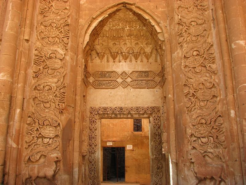
The Mosque of Manuchihr. Manuchihr was the emir of the Shaddadid dynasty that ruled Ani after 1072. The oldest surviving part of the mosque is its still intact minaret perched precariously on the edge of the cliff It has the Arabic word Bismillah (“In the name of God”) in Kufic lettering high on its northern face. The prayer hall, half of which survives, dates from the 12th or 13th century.
The original purpose of the mosque of Manuchihr is debated on both the Turkish and Armenian sides. Some contend that the building once served as a palace for the Armenian Bagratid dynasty and was only later converted into a mosque. Others argue that the structure was built as a mosque from the ground up, and thus was the first Turkish mosque in Anatolia. From 1906 to 1918, the mosque was partially repaired to serve as a museum of findings from Ani’s excavation by the Russian archaeologist Nicholas Marr. Regardless of the building’s origins, the mosque’s four elegant windows display spectacular views of the river and the other side of the gorge.

The Citadel. At the southern end of Ani is a flat-topped hill, the inner castle was built in the time of the Armenian Kamsarakan dynasty in the fourth century A.D. Its defensive walls date to when the Kamsarakan dynasty ruled Ani (7th century AD). Excavations in 1908-09 uncovered the extensive ruins of the palace of the Bagratid Kings of Ani plus the visible ruins of three churches, one the oldest surviving church in Ani, dating from the 6th or 7th century. Most collapsed during an earthquake in 1966.
Ruins of the Mausoleum of the Child Princes in the Inner Fortress on Citadel Hill is thought to have been built around 1050 AD.
The City Walls. Fortified outer walls built by King Smbat (977–989) still encircle the ruins of numerous churches, mosques, and caravanserais that were built under the reign of Ashot III in 964. The walls were later reinforced by the order of Sembat II in 978. The third wall was constructed at the order of Ani Bey, Ebul Menucehir in 1064-1072 after Seljuk Sultan Alparslan conquered Ani in 1064, and strengthened later by his Bagratid family of kings, who encircled the entire city, making for a formidable defence in the bloody conflicts between the Bagratids and the Byzantines, and the Byzantines and the Seljuks. On the northern side, the only part of the site not protected by rivers or ravines was a double line of walls with three gateways – the Lion Gate, the Kars Gate, and the Dvin Gate (also known as the Chequer-Board Gate because of a panel of red and black stone squares over its entrance). The much taller inner wall here had many semicircular towers.

Other Minor Monuments.
Monastery of the Hripsimian Virgins is a convent, a church used by Chalcedonian Armenians, thought to have been built between 1000 and 1200 AD, near the height of Ani’s importance and strength. The Akhurian River below acts as the modern border between Turkey and Armenia.

The single-arched Silk Road bridge over the Akhurian River probably dates from the 13th century; the foundations of several other palaces and smaller residences; the recently excavated remains of several streets lined with shops; etc and a second mosque with a collapsed minaret.

Cave Village. Directly outside of Ani, there was a settlement zone carved into the cliffs. It may predate Ani or have served as an “urban sprawl” when Ani grew too large for its city walls. The caves are sometimes described as Ani’s “underground city,” and signs point to their use as tombs and churches. In the early 20th Century, some of these caves were still used as dwellings. Today, goats and sheep take advantage of the caves’ cool interiors. One highlight of this part of Ani is a cave church with frescoes on its surviving walls and ceiling.

Ani covers a small area and is easily traversed on foot. 8 TL
Ishak Pasha Palace (25/02/2000). A unique Ottoman palace high above the city of Dogubeyazit, with an impressive backdrop of mountains, was built in 1784 by Ishak Pasha, the Second of Cildirogullari. It was originally in the center of the old town on a steep sloping hill surrounded by a ragged side. To build it on the slope, a high-walled terrace and cellars were built on the north, south, and partly west side. Some floors are single, some double, and some parts triple with cellars. Sections were built around two courtyards, with the harem section as the main body. Externally, it is 115 x 50m with an area of 7,699m2. Hot water central heating. Ornamentation is Baroque-Rocco which was in style at the time, with North Caucasian and Iranian blended in, producing an eclectic look. The basis of the motifs and composition is traditional Seljuk art and architecture.
In the first courtyard is the “milk fountain” still supplying highland water, the soldiers’ garrison, and a dungeon originally with only a roof entrance where prisoners were lowered down by rope. Off the second courtyard is a mosque with a nice dome and 4 towers, the main palace and the highlight, the harem. It has a monumental portal, many rooms with fireplaces, and a lovely hall. Most of the ceilings are gone, and a new wood-beamed ceiling covers most everything.
From Dogubeyazit, the highway crossed over a high pass in the mountains to the west. It then descends to the area of Lake Van with no snow and temperatures hovering just above 0°C.
VAN
Tushpa/Van Fortress, the Mound and the Old City of Van. A tentative WHS (13/04/2016). This is a huge fort that extends along the entire length of the narrow mountain. The west side is a high vertical cliff and the walls only extend along the east side. It appears to be a military base and can’t be entered. The wrought iron gate is topped with razor wire.
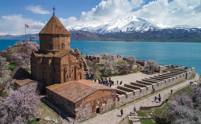
Akdamar Church (Armenian Church of Akdamar Island). A tentative WHS (13/04/2015). The island in Lake Van is about 1km offshore. December was certainly out of season. There was a boat available – but normally it takes 15 passengers at 20TL each or 1 person for 200TL. The island has steep cliffs on its southwest. The church sits on the flat north end.
At Akdamar, I had decisions to make. I wanted to go to Kurdistan, Iraq, but Google Maps only showed routes through Iran and NW Iraq, both visa impossibilities. I Googled Turkey/Kurdistan border crossings and got two: Zete supposedly just opened in 2018 in the corner next to the Iran border, a 275 km, 3½ hour drive, or the Ibrahim Khalil border crossing, the main tourist and truck crossing (and the only one before 2018). The problem Google Maps did not show Zete as even existing.
The drive to the mythical Zete took me over 3 mountain passes – 2730m with slush and -4°C temperatures, 2110m and clear, and 1900m just before Şemdinli and the border. The highways are superb in Turkey, and these were no exception – fast 4-lane or good 2-lane when the other is not possible. After the first pass, an odd reinforced concrete box canal had been constructed to carry the stream. Often, it was above the level of the highway in the extremely narrow canyon.
The trip was basically through snow-covered mountains dropping down into valley floors with none. As I neared Iraq, there was a large military presence with many checkpoints. But they were all very pleasant.
In fact, Zete didn’t exist. I turned around and drove back to Yüksekova. It was almost dark so I simply parked on the side of the highway outside of town for the night. I ate and played bridge until late then all of a sudden was surrounded by several military vehicles with an angry man who spoke no English. After a thorough search and many questions translated on the phone, I was told this was a dangerous place and had to go into town. It had started snowing. I drove into Yüksekova and parked at a gas station. The forecast was for heavy snow. I thought I was screwed – in the middle of the mountains surrounded by high passes, only 4-season tires, but had faith in the great Turkish road system and their winter maintenance.
In the morning, there was 4cm of snow on the ground and it was still snowing. I decided to head west through the mountains of southern Turkey towards the Iraq border. After some slush, the road became clear. One positive was that I was following a river, the Çataksuyu Stream, downhill. The roads got better and the snow, even on the mountains, disappeared. Besides missing a turn and having to deal with difficult soldiers, everything turned out great, at least for the time being. The road followed the same canyon that turned into a magnificent rugged gorge – big steep sloping plates of rock covered in green moss and then with green grass mixed with the ragged mountains.
The next problem arose. Google Maps lost its navigation ability. This has happened before (in Kosovo) and one uses Google Maps Preview. It gives a route but no turns or instructions. It needs to be refreshed every 90 seconds and moved along the route manually.
I reached a turn where the road left the river. I could go south through the Turkey/Iraq border at Üzümlü or the long way around through the Ibrahim Khalil border crossing, the normal and main entry into Kurdistan.
The Turkish military pointed me to Üzümlü. There were no road signs and the road switch backed high up to the top of the mountain where the border was. After the usual bureaucratic mess of Turkish immigration (but eased by the help of one nice guy who spoke English), I finally got to Iraq immigration for another big disappointment. I could cross here but my vehicle couldn’t!!!! Turkey closed their border for an hour at 1:30 and a nice Kurd who spoke good English invited me for a Kurdish lunch of rice, dark noodles, fried chicken and bean soup. In the 3 years, he had worked at this crossing, I was the first native English speaker and the first Westerner. I had to endure Turkish immigration again. I told the nice guy he was the best Turkish immigration officer I had seen. He wasn’t Turkish but a Kurd!
So I returned down the mountain to the river and turned west up through more mountains, over a couple of low passes and finally turned southwest as directed by Google Maps. In a village, the entrance to the road was so insignificant that I missed it twice. It started as narrow rough pavement that climbed to one of the more unusual roads I have travelled – new, wide, cement, no painted lines, a sharp 15 cm shoulder, and a slight corrugated feel due to pouring lines every ⅔m. It seemed to climb forever and then went along the top of the mountains for several kilometres. At one point it continued off the indicated map on Google Maps. It ended at a heavily guarded military checkpoint, also the “end of the road”. The road shown on Google Maps was undrivable.
After many questions and phone calls, I was given two soldiers in full combat gear and guns to take me to the town 60 km away that would give me access to the Iraq border – apparently for my safety as there were “terrorists in the area”. We took a different very steep road down to the original town and stopped at a military base where I was taken in for questioning. They wanted to know why I was in a special military zone and why I had travelled to so many dangerous countries like Syria and Iran and why I wanted to go to Iraq. They eventually became friendly and let me go. The soldiers didn’t continue with me (I was still 45 km from the town) and it was obvious they were there to make sure I got to the interrogation. This was one of my more unusual travel experiences.
It ended up being a long drive to the Iraq border at Ibrahim Khalil border crossing so I ended up taking three whole days to get there. But I saw some nice mountains and canyons in parts of southern Turkey that most people never get to – and I wonder why??
