
- Currency: Hungarian Forint HUF – 355.4 = 1 € (October 2019)
- Diesel (more expensive than gas) but still cheaper than anywhere north of here. HUF 415/l = €1.17/l. I was able to find it as cheap as 411.9 and it was 409.9 in Budapest.
I was in 4 countries in 24 hours on September 29-30th. I left Liechenstein Castle in south central Czech Republic in the late afternoon, overnighted and saw all the sights in Bratislava, the capital of Slovakia, made a short circuit through the northwest corner of Austria to see a windmill and Neusiedlersse National Park, a joint park in both Austria and Hungary. I then entered the Transdanubia part of Hungary where I saw the Esterhazy Palace and continued on my way to see this small corner of NW Hungary north of Budapest.
Podersdorf am See windmill (Retz windmill, Austria). This is a wonderfully well-kept mill. A Dutch cap type, it has a conical plastered bottom and all its vanes. The sign was in German but this is what I think it said: it was built in 1853, renovated in 1956-7, closed in 1977 and became a restaurant in 2003. The gate was locked but one is only a few feet from the windmill.
Hungary – Transdanubia (Györ, Pécs, Székesfehérvar, Veszprém, Kaposvár) September 30-October 1, October 5-6, 2019
I then entered the Transdanubia part of Hungary to see this WHS. Lake Neusiedlersee is quite large and surrounded by basically flat country with some hills to the west. It is agricultural land and vineyards. I haven’t experienced wind this hard for a long time – the van was being tossed all over the road. It must be windy here all the time as there was a giant wind farm.
Fertö / Neusiedlersee Cultural Landscape.
Lake Fertő is situated on the territory of Austria and Hungary, and it was nominated jointly by the two countries for inclusion on the World Heritage list. Part of the Fertő-Hanság National Park, in 1979 it was declared a biosphere reserve by UNESCO, and it is regarded as one of the internationally significant natural water areas of Europe. It is the most western example of the Eurasian steppe lakes, and at the same time it is Europe’s largest salt-water lake.
Neusiedler See National Park. Is on the east and south shores of the lake, the park extends over an area of 97 square kilometres and protects parts of the westernmost lake of the Eurasian Steppe.
The area of the national park is a meeting point for different plant and animal species. These include alpine, pannonian, asian, mediterranean and northern European species. This results in a mosaic of environments, including wetlands, herding meadows, meadows, sand steppes and salt areas. In the west the area is bordered by the Leitha Mountains, the Parndorf Plain in the north and the Hanság in the east. The mire of Hanság was for centuries a part of Lake Neusiedl. Lake Neusiedl itself is situated at the lowest point of the Little Hungarian Plain at an altitude of around 115m above sea level.
The ownership structure of the national park Neusiedler See-Seewinkel is different from that of other national parks in Austria. Neusiedlersee-Seewinkel is not owned by any government but rather by around 1,200 different owners. Most of them are local farmers that receive a yearly compensation for leaving these plots unused.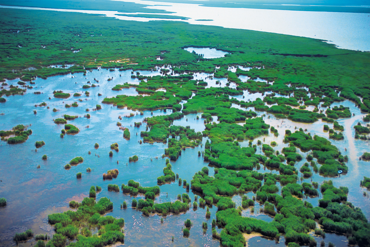
FERTÖ. A NM “small town”, its only redeeming feature is the palace.
Eszterháza (Esterhazy Palace), Fertőd. The Esterhazy dynasty rose from lesser nobility at the end of the 16th century. Though marriage and purchases, they became wealthy and built this palace in 1762 on 700 acres used for hunting. When Nicolas Esterhazy died in 1790, the happy life ended, the castle was abandoned for 100 years and several buildings including the opera house disappeared. In 1900, it was renovated starting the 2nd golden age of the palace. Damaged in WWII when it was operated by the German military, it became a Russian hospital after the war. All the furnishings were destroyed and the place abandoned to be restoration in 1957. It is now owned by the Hungarian state.
See the dining room, sala terrace with its frescoes, the concert hall where Haydn played several times (he lived here for 24 years), the Baroque ceremonial hall and finally the Chinese room with its exotic wood panels. Outside is the palm house and winter garden
Note this can only be seen by guided tour. The only English tour is at 1pm but you can join other languages and follow with a text. 2000, 1000 reduced
GYŐR
Bishop’s Castle. Exhibit on Bishop Boldog Apor Vilmos (1892-1945)on the 70th anniversary of his martyrdom in 1945. Also Gyor in WWII and the German and Soviet occupations. 1000, 500 reduced
Cathedral of our Lady. This has only one side aisle on the left with windows and other small painted on the right walls making it quite dark inside. The style is barouque with altars on every column, gilt and a large altar at the end of the left aisle. The altar is a large painting. All the ceilings are painted but are qite dark. The highlight may be the nicely carved pews.
MILLENARY BENEDICTINE ABBEY of PANNONHALMA and its NATURAL ENVIRONMENT
The history of the abbey, built on the holy mount of the Roman province of Pannonia (Mons Sacer Pannonia), is as old as the history of Hungary itself. The pagan Hungarian tribes arrived in the Carpathian Basin from the east in c. 896. Their leader Géza and his son, the State founder Stephen I, recognised that the Hungarian people could only survive if they created a solid, feudal state and adopted Christianity. The first Benedictine monks settled here in 996 founding the first Benedictine monastery in Hungary. They went on to convert the Hungarians, to found the country’s first school and, in 1055, to write the first document in Hungarian.
The first buildings were destroyed in 1137, then rebuilt – the pillars and early Gothic vault date from the early 13th century and in 1486, the abbey was reconstructed in Gothic style. It became an archabbey in 1541 and was fortified during the Ottoman incursions in the 16th and 17th centuries. It was abandoned at various times during the Turkish occupation and the damaged buildings were reconstructed after. In the 17th and 18th centuries, rich Baroque adornments and extension were added and much of the current façade dates from then. In 1882, the library and tower were built.
After 1950, the Communist state confiscated the property and it was not returned until 1995, one year before the millennium in 1996 when it was entirely reconstructed and renovated. It became a WHS in 1996. 3000
It has been visited by Pope John Paul II in 1996 and the Dalai Lama in 2000.
Basilica – the oldest surviving is the wall of the second aisle from the 12th century. The main altar, pulpit, frescoes on the ceiling and upper stained glass date from the 1860s.
Porta Speciosa (ornate entrance)

Cloister (1472)

Library (early 19th). The ceiling has the allegories of the first medieval university faculties (law, theology, medicine and the arts). The library today has 360,000 volumns.
Baroque Refectory (1720s). A 2-story high hall. The secco on the ceiling depicts King Saint Stephen. The side wall’s biblical scenes are connected to eating.
Millennium Monument. 7 monuments were built in the Carpathian basin fro the 1896 millennium but only one exists today – originally a 26m high dome with a colossal brass relief but the outer dome was removed so now the circular building has a low dome, unfinished fresco on the eastern wall.
Our Lady Chapel (1714). Three Baroque chapels with romantic ornamentation from the 1860s.
Botanical Garden. 400 tree species, many rare in Hungary.
Archives. Valuable collection of documents from the first centuries of Hungarian statehood. Monastery charter from 1001-2, the 1055 charter of Tihany Abbey (first written text in Hungarian).
Szent Gellert College of Theology
High School
Winery. Wine making started in 996, dissolved in Communist times and revived since when the vineyards were replanted starting in 2000 with 37 hectares of grapes.

FRONITERS of the ROMAN EMPIRE – RIPA PANNONICA in HUNGARY Tentative WHS (22/06/2009)
Pannonian Limes is that part of the old Roman fortified frontier known as the Danubian Limes that runs for approximately 420 kilometres from the Roman camp of Klosterneuburg in the Vienna Basin in Austria to the castrum in Singidunum (Belgrade) in present-day Serbia. The garrisons of these camps protected the Pannonian provinces against attacks from the north from the time of Augustus (31 BC-14 AD) to the beginning of the 5th century. In places this section of the Roman limes also crossed the river into the territory of the barbarians (Barbaricum).
The Danubian limes was one of the most turbulent regions in the European part of the Roman Empire and, during more than 400 years of Roman rule, Pannonia was one of its most important provinces, especially after the abandonment of Dacia Traiana in 271 AD, because from that point on, the pressure of migrating peoples on this section of the limes increased still further. The limes also had a great influence on the economic and cultural life of the civilian population because its hinterland was one of the main supply areas for the border troops and these in turn were the guarantors of the rapid Romanisation of the province.
The majority of the occupying forces were stationed in camps (castra), small forts (castella), watchtowers, burgi and fortified bridgeheads that were built at regular intervals along the riverbank. In an emergency, these units were reinforced by the legions which had their headquarters in four major military garrison towns. With its advance to the Danube, the Roman Empire became engaged in a long series of conflicts with trans-Danubian Germanic and Sarmatian barbarian and migrant peoples, that finally ended in the 5th century with the collapse of the Empire in the west.
Limes Romanus – Roman Antique Monuments on the Middle Danube. Expansion of the Roman Empire incorporated today’s Panonia province in south- east Slovakia in the 1st to the 4th century. As the Danube River was the natural northern border of the empire, Romans gradually constructed a large border system of fortresses, so called Limes Romanus. The military fortress in Iža and in Bratislava– Rusovce represent typical types of camps on this Roman border.
Kelemantia Roman Castellum in Iža. Created as the bridgehead of a camp of legions and the civil town of Brigetio is one of the largest Roman building complexes in Barbaricum. It is a proof of long-term military presence of Romans on northern side of Danube. In 3rd century the castle was hardly impaired and reconstructed and was still important in the 4th century but unoccupied from the 5th century.
SYSTEM of FORTIFICATIONS at the CONFLUENCE of the RIVERS DANUBE and VÁH IN KOMÁRNO – KOMÁRON Tentative WHS (12/01/2007)
The fortress is situated at a ford on the crossroads of merchant roads – the confluence of the rivers Váh and Danube, a strategic importance appreciated by the Romans, who built the Danube Limes fortifications. Komárno was first mentioned in the Anonymous work Gesta Hungarorum, from the time of the rule of Belo Ill. During the Tartar invasions, when a great part of this territory was plundered, only a few strong castles were able to defend themselves including Komárno as mentioned by Belo IV in 1245. After the retreat of the Tartars from Hungary, the king, supported medieval towns by granting 25 towns great privileges. Komárno was added to the list in 1265.
During the reign of Matej Korvin, the castle was given a renaissance look. Bastion fortifications were built in the last half of the 16th century, the first fortress of this type in the Central Europe (called the Old Fortress). It was extended in the late 1600s with the New Fortress, both with the pushed out bridgeheads of St. Nicolas and St. Peter and they resisted the Turkish wars. The most advanced Italian and French fortification architecture was used – in the shape of a pentagon and its two East bastions connected behind moats to the two back bastions of the Old Fortress. During the Napoleon wars, the fortifications were rebuilt and extended with ramparts-redoubts extending from Danube to 3 km far to the west of the central fortress to the Váh River. The exterior defensive circle of two bastion lines – Palatine and V6h, and four pushed out forts – the V5h bridgehead, Fort Sandberg and Igmand Fortress on the other side of the Danube, currently in Hungary – were created.
The Palatine line (named after the palatine Jozef) was added in 1839-1847 – 5 pentagonal bastions (mouth 21m, face 108 m and height 7 m) connected in one continual chain stretching 5kms. The Váh line was strengthened in the Prussian-Austrian wars of the 1860s. Both lines represented the peak of bastion fortifications of the new Prussian type. In the 1870’s, it was the largest fortress in the Austrian-Hungary empire capable of holding 200,000 soldiers. But by the end of the 19th century the fortifications did not fulfill the needs of -a new era and they became obsolete for effective defense.
Fort Monstar. On the Hungarian side of the river upstream from Komarno, it is the biggest modern fortress in Central Europe. It was built between 1850-71 to control ship traffic on the Danube, but was never involved with military action. It has 3-4m thick ramparts, the casements are sever kilometers long, covers 25 acres, has 640 chambers and was able to hold 8000 soldiers. By the time it was completed, it was already out of date. Between 1945-90, it was a Soviet secret ammunition dump but has had no military occupation since 1990. It now is a venue for festivals and concerts. The museum relates the military history, medieval weapons, the Monarchy period, bread making and when occupied by the Soviets.
The stonework itself is a marvel – all perfectly cut polygonal blocks. 1600, 1200 reduced
ESZTERGOM
LE CHÂTEAU-FORT MÉDIÉVAL D’ESZERGOM
A tentative WHS (11/08/1993).
Esztergom Castle (Royal Palace). A Romanesque Palace, the back is all modern brick reconstruction with original stonewalls facing the river. Visit the terrace for views, see the art gallery and castle theatre, knight’s hall and lapidarium. 2400, 1800 reduced
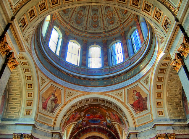
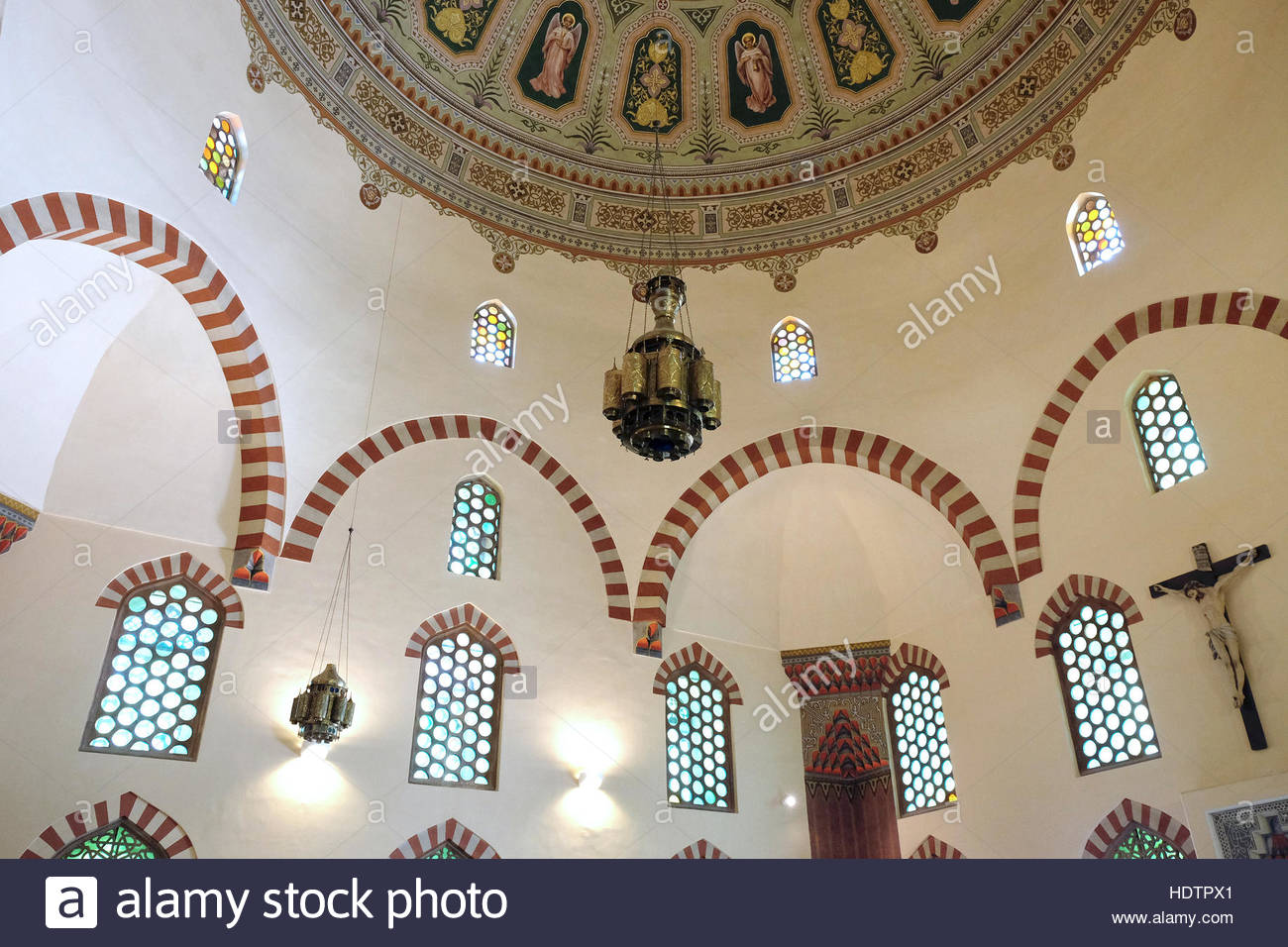
Esztergom Basilica. Single nave church with grand crossing under a huge dome, adorned with gilt geometrics and sun crests. Walls red and/mainly grey marble with gilt capitals. Chancel has large fresco in the ceiling. Large paintings in the apse and ends of the transept. Most of the light comes from the dome and 6 high semi-circular window. Two side chapels with marble and a terracotta roof.
Crypt. Dating from 997, it is a grand space of vaulted brick with the walls full of tombs of past bishops. 10 large columns in the centre complement the 16 on the sides. The highlight is the tomb of Bishop Csernock Janos (bishop from1913-27), a large marble sarcophagus with a huge bronze angel draped over his body on top.
Dome. I climbed the 352 steps with stops at the panorama, a walk around the glass part of the dome and then the walk around the large copper dome on top. Great views down to the Danube and town of Esztergom.
Seeing the church is free. A combined ticket to see the crypt and climb the dome was 1200, 800 reduced and probably not worth it.
After Eszergom, I returned to Slovakia to finish seeing the eastern part of the country, returning to visit the karst area from Hungary. After seeing Budapest, I drove SW to this last part of Transdanubia
PÉCS
Early Christian Necropolis of Pécs (Sopianae) World Heritage Sites
The city of Pécs was founded by the Romans in the second century. By the fourth century, the city – known then as Sopianae – became a prosperous provincial capital and one of the most significant centers of early Christianity. The cemetery’s history can be traced back to the first century; this was the period when, thanks to its northern expansion, the Roman Empire reached today’s Transdanubia, and established the province of Pannonia. In the second and third centuries, a slow Romanization had begun of the population living there. Due to the province’s main function to protect the Empire, significant numbers of soldiers from the eastern territories were installed, giving way for early Christianity to enter the city.
The Paleo-Christian necropolis of Pécs is regarded as one of the most significant Roman provincial cemeteries. Both its architecture and incredible mural paintings are regarded as some of the most outstanding accomplishments in Europe. The cemetery’s significance is present not only in the fact that we can get an insight into the Roman Empire’s northern and western provinces’ architecture, art and burial habits, but also in its countless burial structures: brick tombs, burial structures made of stone, chapels and crypts.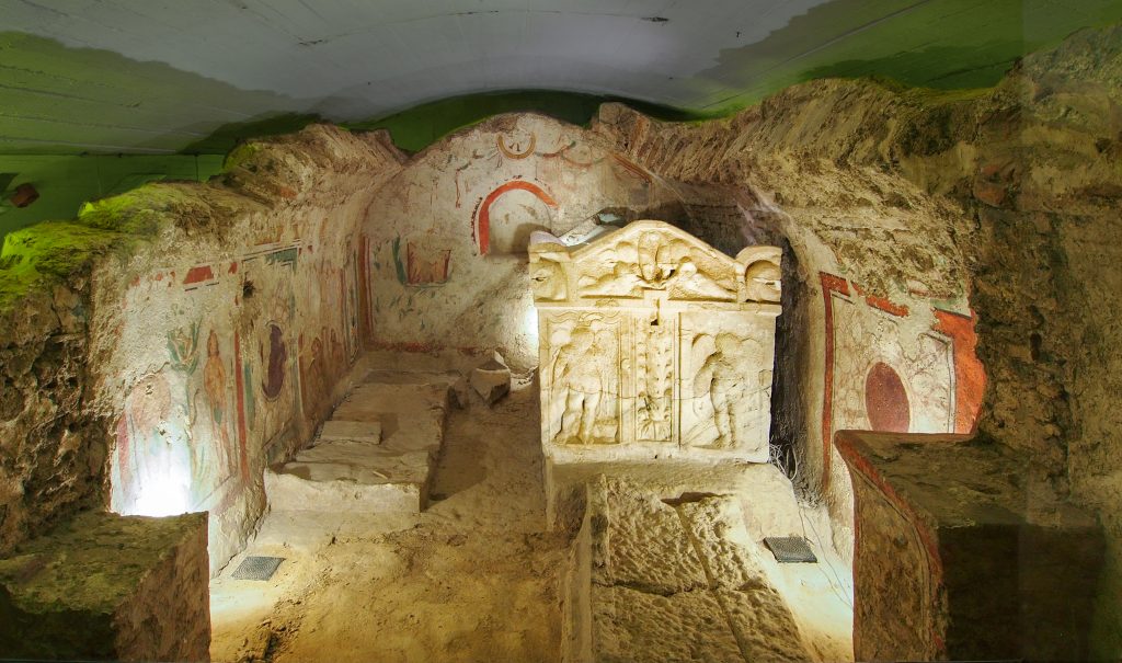 The complex discovered in Pécs served mainly as the burial place of wealthy families. The two-story building’s underground region is the undercroft, the true crypt, where the deceased were placed in brick tombs or – more rarely – in sarcophagi. Over this crypt, a memorial chapel (memoria, mausoleum) was erected. The two-story buildings had a twofold task: to serve as the burial site and as the location of the burial ceremony. From outside, the memorial is reinforced by buttresses that extend into the interior of the chapel: two on the north, and two on the south side. Both opposing parts were likely connected by arches, amongst which the east is the chancel arch, that separates the sanctuary from the church nave. There is a western arc as well, that separates the central space of the church from the west, originally from where the tomb stairs opened.
The cemetery also has many important building complexes that warranted exploration, although this took several long centuries. The number I (Peter and Paul) hall was discovered in 1782 in the episcopal archives during the demolition of the Renaissance palace, and as its importance was already recognised in the 18th century, it was protected by a simple surrounding brick building which was still characteristic of the time. Thanks to the preservation of the find, it can still be visited today by the general public. Later, in the early twentieth century, archaeologist Otto Szőnyi and architect István Möller carried out significant exploratory activities on the site. They explored the Cella Trichor, that is, the three-lobed chapel and number III crypt. Their goal was to build a corridor to the already-known Peter and Paul tomb and to make the memorial visitable. Slowly, over the course of the last century, the rest of the crypt has come to light and now a total of sixteen tombs are found altogether. In 2005-2006 they completed the construction work with the Cella Septichora Visitor Center. The Early Christian Mausoleum was discovered in 1975, a protective building was prepared for it then as well, but the presentation of the complex was made possible by the results of the 2005-2006 exploration.
Becoming a World Heritage Site took a very long period of time, as the nomination process began in 1996. At this time Pecs’ entire historic downtown was put on the list, as there are many buildings characteristic of historical periods that can be found there. However, the bid was modified to be narrowed down to include only the tombs; this way the nomination was sure to be successful. In addition to its uniqueness, UNESCO also chose to add it to the World Heritage List because the complex represents a very narrow cross-section of history. The early Christian tombs in Pécs had been built by a bygone civilization, but have served a surviving and thriving culture: Christianity.
Downtown Candlemas Church of the Blessed Virgin Mary (Mosque of Pasha Qasim). Saint Bartholomew Parish Church was first built around 1300, safeguarding St Bartholomews relics (his right hand had been brought back from the Holy Land). In the 14th and 15th century, this was demolished and the second Gothic St Bartholomems built precisely on top of the walls of the bone house. In the 15th century a larger chancel was built and the northern aisle added. In 15th, it was reconstructed with the entire nave removed and a new 3-naved church built – 47m long, 24m wide covered in late Gothic rib vaulting. Following the Ottoman take over the church burned down and a mosque was built using the stones from the church. The tower of the church was removed and a minaret built. Facade covered by arches and a hemispheric dome built. in 1685, the Jesuits converted it into a church – minaret and porch were removed and 2 rooms added, and a domed Baroque chancel and sacristy built. Crypts constructed under the church. It changed hands several times until the Cistercian in 1813 took it over, the façade was changed onion dome built. 1931-41 the Ottoman church was restored making the church one of Hungary’s best Ottoman monuments.
Wow what a nice and unusual church. About one-third is a semicircle with a balcony above. Murals decorate the back of the balcony the entire flat wall. In the middle is a large white marble altar. On the other side is a large square building, the original mosque with red/white stripped arches and stones over the windows. The dome is magnificent with many angels, Islamic motifs and a large central sun. All the windows are small round panes.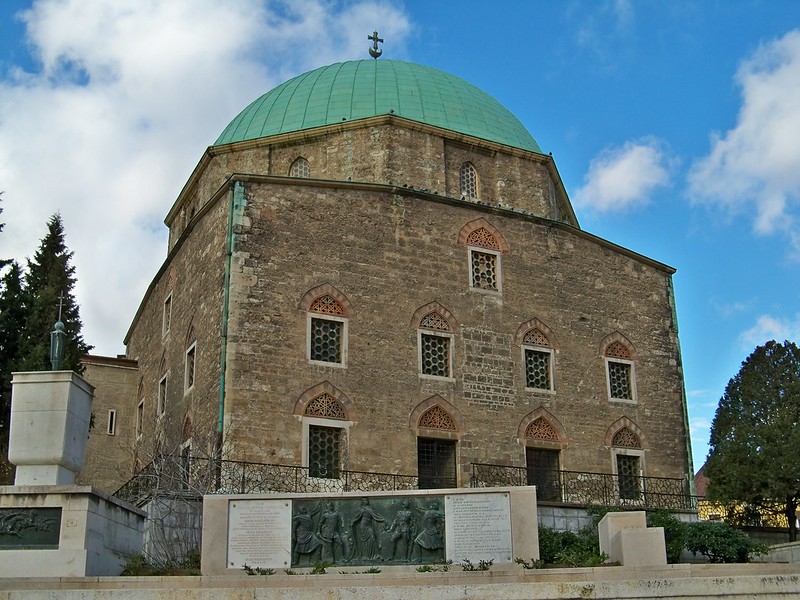

Crypt. Under the entire church, this holds graves from 1700s, 1800s and modern. Memorial corner of Martyrs – 5 martyrs who sacrificed their lives for their faith on March 26, 1704 in Pecs.
Danube-Drava National Park. In the south west of Hungary, the 490km2 park was founded in 1996. The majority of the national park sites are located within the Danube and Drava floodland areas, of which 190 km² are Ramsar wetlands. Black stork and White-tailed eagle populations are of European significance. Seven invertebrate species are found only here in Hungary. Habitats along the Drava host more than 400 protected plants and animals. Species endemic to national park areas include the black hawthorn and the Drava caddis fly.
NOMAD MANIA Hungary – Transdanubia (Györ, Pécs, Székesfehérvar, Veszprém, Kaposvár)
World Heritage Sites
Early Christian Necropolis of Pécs (Sopianae)
Fertö / Neusiedlersee Cultural Landscape
Tentative WHS
Frontiers of the Roman Empire – Ripa Pannonica in Hungary (22/06/2009)
Le Château-fort médiéval d’Esztergom (11/08/1993)
System of Fortifications at the Confluence of the Rivers Danube and Váh in Komárno – Komárom (12/01/2007)
The Network of Rural Heritage Buildings in Hungary (28/12/2000)
Sights (Temporarily Reinstated)
Esterházy-castle Fertőd
Győr Old Town
Harkány Spa Town
Lake Balaton
Sopron
Borders
Austria-Hungary
Croatia-Hungary
Hungary (river/lake border)
Hungary-Slovakia
Hungary-Slovenia
XL
Mosonmagyaróvár Panhandle
KOMAROM/KOMARNO
Tentative WHS: System of Fortifications at the Confluence of the Rivers Danube and Váh in Komárno – Komárom (12/01/2007)
Castles, Palaces, Forts: Komárom: Fort Monostor
Railway, Metro, Funiculars, Cable Cars
Balatonfenyves narrow-gauge railway
Hungary Intercity Railway Experience
Railjet
Museums
Balatonfured: Vaszary-Villa
Nagykanizsa: Thúry György Múzeum
Castles, Palaces, Forts
Csesznek: Csesznek Castle
Fertőd: Eszterháza
Kőszeg: Jurisics Castle
Mohacs: Buso Courtyard
Nagyvazsony: Nagyvazsony Castle (Kinizsi Castle)
Siklos: Siklos Castle
Simontornya: Simontornya Castle
Szigliget: Szigliget Castle
Religious Temples
Heviz: Holy Spirit Church
Pannonhalma: Pannonhalma Abbey
Szentgotthárd: Szentgotthárd Abbey
World of Nature
Balaton Uplands
Duna–Dráva
Fertő–Hanság
Festivals
Balaton Sound
Potato day, Gyenesdiás
Rockmaraton
Volt
Experiences
Play/hear cimbalom
Taste Fatányéros
Taste Goulash
Entertainment/Things to do: Zamárdi Adventure Park
Botanical Gardens: Alcsutdoboz: Alcsut Arboretum
Windmills: Tés Windmills
Beaches: Lake Balaton Beaches
Caves: Szelim cave
Ski Resorts: Ski resort Síaréna Eplény
Monuments: Csertő: Hungarian-Turkish Friendship Monument
Open-Air Museums
Szenna Open Air Museum
Zalaegerszeg: Zalaegerszeg open air museum
European Cities
GYŐR
Museums: Municipal Museum of Art
Castles, Palaces, Forts: Bishop’s Castle
Religious Temples
Cathedral of our Lady
The Five Churches
KAPOSVÁR
Museums: Rippl-Ronai Museum
SÖPRÖN
XL: Söprön area
Botanical Gardens: Sopron Botanical Garden
SZÉKESFEHÉFVÁR
Castles, Palaces, Forts: Bory Castle
SZOMBATHELY
Museums: Szombathely: Iseum Savariense Archeology Workshop and warehouse
TATABANYA
Monuments: Turul Monument
VESZPRÉM
Castles, Palaces, Forts: Veszprem Castle
Zoos: Kittenberger Kálmán Zoo
Villages and Small Towns
Fertőrákos
Fonyod
Hévíz
Kőszeg
Mosonmagyaróvár
Óbánya
Siklos
Szigetvar
Tapolca
ESZTERGOM
Tentative WHS: Le Château-fort médiéval d’Esztergom (11/08/1993)
Castles, Palaces, Forts: Esztergom Castle & Basilica
Religious Temples” Esztergom Basilica
SUMEG
Museums: Carriage Museum
Castles, Palaces, Forts: Sumeg Castle
ZIRC
Religious Temples: Zirc Abbey
TATA
Castles, Palaces, Forts: Tata Castle
TIHANY
Tentative WHS: The Tihany Peninsula (11/08/1993)
Museums: Babamuzeum
Religious Temples: Tihany Abbey
KESZTHELY
Museums: Balaton Museum
Castles, Palaces, Forts: Festetics Palace
Markets: Keszthely Market
Railway Museums: Történelmi Modellvasút és Vadászati Múzeum
Vehicle Museums: Cadillac Museum