
TIPS & OBSERVATIONS
1. Time. Norway is one hour behind Finland. Norway actually spans three time zones. Eastern Norway is over Istanbul and western Norway lies over the British Isles.
2. Diesel prices. Diesel is cheaper here than gas (like Finland and unlike Sweden) but is still expensive – NOK usually about 15.45/litre = €1.61 13.83 was the cheapest. It is worthwhile waiting for cheaper gas if possible. Gas wars and competition in Norway are common. On my first trip through southern Norway, I actually bought gas at 11.30 as I just happened by luck to encounter gas wars.
3. Norwegian Auto Pass. All roads in southern Norway are tolled but I haven’t encountered toll camera gantries since crossing the border from Finland in the north. Register your vehicle as the tolls are automatic as you pass under the camera gantries.
4. Roads and Norwegian Drivers. Norwegian roads are of excellent quality but only two-lane in the north. There are innumerable speed zones for every town. The highest speed is 90km/hour and 30-60 in most towns. Speed radar cameras are frequent but you always get a warning. As a result there should be no excuse for getting speeding tickets.
In the summer, there are many motorhomes and cars pulling trailers (caravans) and they always seem to be driving below the advertised speed limit so they back up traffic. Norwegian drivers are very cautious and conservative and seem to have endless patience behind these slow drivers so they don’t pass readily. That is what creates the long lines of traffic. Passing and driving well over the speed limit is quite safe again as the speed cameras are always advertised. I set my cruise control at 4-5kms over the speed limit and travel faster than everyone else on the road.
5. Access to northern Norway. The cheapest and easiest way to access northern Norway by car is via Sweden. Driving from Oslo has several issues: road tolls in southern Norway, gas and food prices are cheaper in Sweden and it is a long drive on winding mountain roads crossing fjords on ferries. Between Stavanger and Bergen is a lot of desolate country with little traffic. The scenery in Norway is better of course.
6. Currency: Norwegian Krone NOK. 1€ = 9.62 NOK
Norway – Nord-Norge (Tromso, Narvik, Kirkenes) July 21-24, 2019
The E8 (that goes all the way from Tromso, Norway to Tornio, Finland) follows the Sweden/Finland border for 622kms. The north part of Finland here is the NM “XL” series Lapland northwest panhandle (Enontekiö)
I stopped in Kilpisjärvi, the last town in Finland to fill up with cheap Finnish gas (if you can call €1.45 cheap gas). I then crossed into Norway. This is the only Schengen border where customs stops you. They asked where I was going (Norway!), where I was coming from (Finland!) and what my travel plans were, but surprisingly didn’t ask for my passport. They asked how much tobacco and alcohol I had. My guess is that they were sizing me up to see if I could afford the ridiculous prices.
The low forested “mountains” had many snow patches. I stopped at a lovely wilderness campsite with a toilet. The mosquitoes were out in full force so I put my screen in my window and slept through a completely light night.
I left at 7am for the 145km, 2-hour drive into Tromsø. After 4000kms of flat forest, the mountains were welcome scenery. Descend to the Skibotn on a great fjord and a very large waterfall south of town. Rugged snow capped mountains lined both sides of the fjord. Several animal overpasses cross the highway. There were only 3 speed cameras, both announced well in advance.
TROMSO (pop 77,000)
Tromso is the major cultural hub above the Arctic Circle famed for the Northern Lights. It is the largest urban area in northern Norway and third largest north of the Arctic Circle in the world. Most of the city is located on the island of Tromsøya and is connected to the mainland by the Tromsø Bridge and Tromsøysund Tunnel and to the island of Kvaløya by the Sandnessund Bridge.
it is warmer than most other places at the same latitude due to the warming effect of the Gulf Stream with relatively mild winters and tree growth.
The historic city center has centuries old wooden houses, the oldest dating from 1789.
History. It has been inhabited since the end of the Ice Age 10,000 years ago. First descriptions date to a Norse chieftain from the 890s. The fjord south is the traditional border between Norse and Sámi coastal settlements and most of its early population was Sámi. The first church was built in 1252 along with a turf rampart. It was the frontier city towards Russia. With a population of only 80, it was given its city charter in 1794 coinciding with the end of Bergen’s centuries-old monopoly in the trade of cod. Between 1820-50, it became a center for Arctic hunting. In the 19th century, it became known as the “Paris of the North” as it appeared to be more sophisticated than visitors from the south typically expected. By the end of the 19th century, it had become a major Arctic trade center from which many Arctic expeditions originated often recruiting crews from Tromso (Roald, Amundsen, Umberto Nobile and Fridtjof Nansen).
The opening of the airport in 1964 was a major development. The Norwegian Polar Institute moved from Oslo in 1998.
Over 100 nationalities live here with Sami, Russians and Finns the prominent minorities. The Sami culture became almost invisible by the 1970s but has been revitalized. It has the world’s northernmost mosque and the Catholic church has the world’s northernmost bishop (congregation of 350).
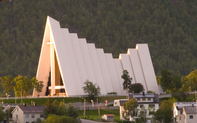
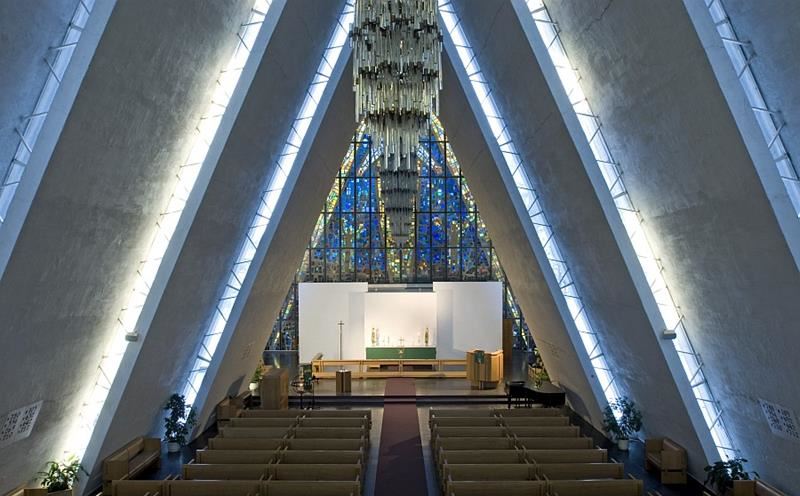
Arctic Cathedral. Built in 1965, its distinctive peaked roof and soaring glass windows dominates the skyline on the east side of the fjord across from the main city centre. The roofline is multi-stepped panels – the front eight are separated by a short glass panel and the last three by stained glass. A huge geometric stained glass window covers in the entire apse. Midnight sun concerts are held every night at 11pm (105 NOK) and organ recitals every afternoon at 2pm (50 NOK). It costs 50 NOK to enter the church (one of the few churches in the world to charge a fee).

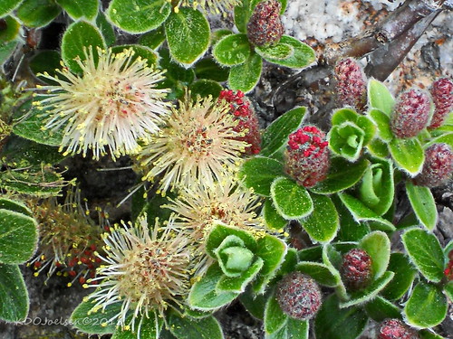
Arctic–Alpine Botanic Garden. The world’s northernmost botanic garden has 27 collections of plants from the Arctic and from alpine and cool parts of all continents. Most collections are found in distinctive rock landscapes imitating nature. There is also a geology walk with rock types from north Norway in the birch forest above the garden. Free!!
Wow, what a spectacular garden. Tiny rock paths wind through the rockeries. There were some fascinating signs. New Zealand, New Caledonia and Madagascar are the oldest islands in the world at 80 million years. NZ formed before mammals appeared and thus has none. The insects did not develop colour vision, so all the flowers are white.
Northern Norway Science Centre. Exhibits on climate and weather, energy and the environment, up north and body and mind (wetlab, cochlea). 100 NOK
Northern Light Planetarium. This is in the Science Centre. 120 NOK
Tromsø University Museum. Whaling: the Norwegian minke whale hunt started in the late 1920s; all commercial whale hunting was forbidden in 1987. Norway restarted the minke hunt in 1993 because the population was large and the hunt sustainable (more than 100,000 minke whales live in the NE Atlantic today). 48% of Norway was wilderness in 1910, now it is only 10%.
2nd floor: 50,000 Sami live in 4 countries (Norway, Sweden, Finland and Russia and share a common language and culture. Archaeology, great altars, icons and pulpits. Unfortunately this floor is only in Norwegian. NOK 70, 50 reduced
MS Polstjerna. It sailed for 33 hunting seasons killing 97,000 seals. It holds a history of Arctic exploration and a monument to Arctic hunting and the history of Tromso. A ship museum, it is in a fancy glass enclosure on the water with its mast sticking out the roof. It had an exhibit entitled Snowhow – what Arctic explorers learned from the Inuit, Sami and other explorers about survival while exploring these environments.
Polaria. This is an aquarium with Arctic fish and wildlife and has exhibits on climate change and polar research. The M/V Lance is a polar research vessel that purposely got locked in the ice for 6 months in 2015 conducting research. Polaria is associated with the next door Polar Institute. NOk 145, 95 reduced
Tromsø Cathedral. Built in 1861, this grand wood church (the only wood cathedral in Norway) has a congregation of 6700, hold 100 services per year and gets 10,000 visitors. There are regular concerts. Inside there are balconies over low aisles. Wood beams and iron rods support a white peaked roof. The altar painting dates from 1864 and under it is a 1614 bible. The 40m tower dates from 1862 and has 4 clock faces. The church was surrounded by a cemetery that was converted into the present park when the cathedral was built.
The first church in Tromso was built in 1252, the world’s most northerly church. A new church was built in 1711-1803 and this one replaced it when a larger church was needed. It can seat 608. NOK 20 (I don’t think it is worth paying to go inside, there are few distinguishing things)
Roald Amundsen Monument. In a small park near the cathedral, the copper statue has Amundsen standing in front of a small Norwegian flag on a thin natural tree. For some reason his lower body is surrounded by a wood box.
Roald Amundsen (1872 – 1928) was a Norwegian explorer of polar regions and a key figure of the Heroic Age of Antarctic Exploration. He led the first expedition to traverse the Northwest Passage in 1906 and the first expedition to the South Pole in 1911. He led the first expedition proven to have reached the North Pole in 1926. He disappeared while taking part in a rescue mission for the airship Italia in 1928.
Early life. Amundsen was born to a family of Norwegian ship owners and captains in Borge. At 21, he promptly quit university for a life at sea. Amundsen had hidden a lifelong desire inspired by Fridtjof Nansen’s crossing of Greenland in 1888 and Franklin’s lost expedition. He decided on a life of intense exploration of wilderness places.
Belgian Antarctic Expedition. Amundsen joined the Belgian Antarctic Expedition as first mate. It became the first expedition to overwinter in Antarctica. The Belgica, whether by mistake or design, became locked in the sea ice at 70°30′S off Alexander Island, west of the Antarctic Peninsula. The crew endured a winter for which they were poorly prepared. The doctor for the expedition, the American Frederick Cook, probably saved the crew from scurvy by hunting for animals and feeding the crew fresh meat.
Northwest Passage. In 1903, Amundsen led the first expedition to successfully traverse Canada’s Northwest Passage between the Atlantic and Pacific oceans. He planned a small expedition of six men in a 45-ton fishing vessel, Gjøa, in order to have flexibility. His ship had relatively shallow draft. His technique was to use a small ship and hug the coast. Amundsen had the ship outfitted with a small 13 horsepower single-screw paraffin engine.
They traveled via Baffin Bay, the Parry Channel and then south through Peel Sound, James Ross Strait, Simpson Strait and Rae Strait. They spent two winters at King William Island, in the harbor of what is today Gjoa Haven. During this time, Amundsen and the crew learned from the local Netsilik Inuit people about Arctic survival skills, which he found invaluable in his later expedition to the South Pole. For example, he learned to use sled dogs for transportation of goods and to wear animal skins in lieu of heavy, woolen parkas, which could not keep out the cold when wet.
Leaving Gjoa Haven, he sailed west and passed Cambridge Bay, which had been reached from the west by Richard Collinson in 1852. Continuing to the south of Victoria Island, the ship cleared the Canadian Arctic Archipelago on 17 August 1905. It had to stop for the winter before going on to Nome on Alaska’s Pacific coast. The nearest telegraph station was 500 miles (800 km) away in Eagle. Amundsen traveled there overland to wire a success message on 5 December, then returned to Nome in 1906. Later that year he was elected to the American Antiquarian Society.
The crew returned to Oslo in November 1906, after almost three-and-a-half years abroad. Gjøa was returned to Norway in 1972. After a 45-day trip from San Francisco on a bulk carrier, she was placed on land outside the Fram Museum in Oslo, where she is now situated inside her own dedicated building at the museum.
South Pole Expedition. Amundsen next planned to take an expedition to the North Pole and explore the Arctic Basin. Finding it difficult to raise funds, when he heard in 1909 that the Americans Frederick Cook and Robert Peary had claimed to reach the North Pole as a result of two different expeditions, he decided to reroute to Antarctica. He was not clear about his intentions, and Robert F. Scott and the Norwegian supporters felt misled. Scott was planning his own expedition to the South Pole that year. Using the ship Fram, earlier used by Fridtjof Nansen, Amundsen left Oslo for the south on 3 June 1910. At Madeira, Amundsen alerted his men that they would be heading to Antarctica, and sent a telegram to Scott: “Beg to inform you Fram proceeding Antarctic—Amundsen.”
Nearly six months later, the expedition arrived at the eastern edge of the Ross Ice Shelf (then known as “the Great Ice Barrier”), at a large inlet called the Bay of Whales, on 14 January 1911. Amundsen established his base camp there, calling it Framheim. Amundsen eschewed the heavy wool clothing worn on earlier Antarctic attempts in favour of adopting Inuit-style furred skins.
Using skis and dog sleds for transportation, Amundsen and his men created supply depots at 80°, 81° and 82° South on the Barrier, along a line directly south to the Pole. Amundsen also planned to kill some of his dogs on the way and use them as a source for fresh meat. A small group, including Hjalmar Johansen, Kristian Prestrud and Jørgen Stubberud, set out on 8 September, but had to abandon their trek due to extreme temperatures. The painful retreat caused a quarrel within the group, and Amundsen sent Johansen and the other two men to explore King Edward VII Land.
A second attempt, with a team of five made up of Olav Bjaaland, Helmer Hanssen, Sverre Hassel, Oscar Wisting, and Amundsen, departed base camp on 19 October. They took four sledges and 52 dogs. Using a route along the previously unknown Axel Heiberg Glacier, they arrived at the edge of the Polar Plateau on 21 November after a four-day climb. The team and 16 dogs arrived at the pole on 14 December, a month before Scott’s group. Amundsen named their South Pole camp Polheim. Amundsen renamed the Antarctic Plateau as King Haakon VII’s Plateau. They left a small tent and letter stating their accomplishment, in case they did not return safely to Framheim.
The team arrived at Framheim on 25 January 1912, with 11 surviving dogs. They made their way off the continent and to Hobart, Australia, where Amundsen publicly announced his success on 7 March. He telegraphed news to backers.
Amundsen’s expedition benefited from his careful preparation, good equipment, appropriate clothing, a simple primary task, an understanding of dogs and their handling, and the effective use of skis. In contrast to the misfortunes of Scott’s team, Amundsen’s trek proved relatively smooth and uneventful.
Northeast Passage. In 1918, an expedition Amundsen began with a new ship, Maud, lasted until 1925. Maud was carefully navigated through the ice west to east through the Northeast Passage. With him on this expedition were Oscar Wisting and Helmer Hanssen, both of whom had been part of the team to reach the South Pole. In addition, Henrik Lindstrøm was included as a cook. He suffered a stroke and was so physically reduced that he could not participate.
The goal of the expedition was to explore the unknown areas of the Arctic Ocean, strongly inspired by Fridtjof Nansen’s earlier expedition with Fram. The plan was to sail along the coast of Siberia and go into the ice farther to the north and east than Nansen had. In contrast to Amundsen’s earlier expeditions, this was expected to yield more material for academic research, and he carried the geophysicist Harald Sverdrup on board.
The voyage was to the northeasterly direction over the Kara Sea. Amundsen planned to freeze the Maud into the polar ice cap and drift towards the North Pole—as Nansen had done with the Fram—and he did so off Cape Chelyuskin. But, the ice became so thick that the ship was unable to break free, although it was designed for such a journey in heavy ice. In September 1919, the crew got the ship loose from the ice, but it froze again after eleven days somewhere between the New Siberian Islands and Wrangel Island.
During this time, Amundsen suffered a broken arm and was attacked by polar bears. As a result, he participated little in the work outdoors, such as sleigh rides and hunting. He, Hanssen, and Wisting, along with two other men, embarked on an expedition by dog sled to Nome, Alaska, more than 1,000kms away. But they found that the ice was not frozen solid in the Bering Strait, and it could not be crossed. They sent a telegram from Anadyr to signal their location.
After two winters frozen in the ice, without having achieved the goal of drifting over the North Pole, Amundsen decided to go to Nome to repair the ship and buy provisions. Several of the crew ashore there, including Hanssen, did not return on time to the ship. Amundsen considered Hanssen to be in breach of contract, and dismissed him from the crew.
During the third winter, Maud was frozen in the western Bering Strait. She finally became free and the expedition sailed south, reaching Seattle, in the American Pacific Northwest in 1921 for repairs. Amundsen returned to Norway, needing to put his finances in order. He took with him two young indigenous girls, a four-year-old he adopted, Kakonita, and her companion Camilla. When Amundsen went bankrupt two years later, however, he sent the girls to be cared for by Camilla’s father, who lived in eastern Russia.
In June 1922, Amundsen returned to Maud, which had been sailed to Nome. He decided to shift from the planned naval expedition to aerial ones, and arranged to charter a plane. He divided the expedition team in two: one part, led by him, was to winter over and prepare for an attempt to fly over the pole. The second team on Maud, under the command of Wisting, was to resume the original plan to drift over the North Pole in the ice. The ship drifted in the ice for three years east of the New Siberian Islands, never reaching the North Pole. It was finally seized by Amundsen’s creditors as collateral for his mounting debt.
The attempt to fly over the Pole failed, too. Amundsen and Oskar Omdal, of the Royal Norwegian Navy, tried to fly from Wainwright, Alaska, to Spitsbergen across the North Pole. When their aircraft was damaged, they abandoned the journey. To raise additional funds, Amundsen traveled around the United States in 1924 on a lecture tour.
Although he was unable to reach the North Pole, the scientific results of the expedition, mainly the work of Sverdrup, have proven to be of considerable value. Much of the carefully collected scientific data was lost during the ill-fated journey of Peter Tessem and Paul Knutsen, two crew members sent on a mission by Amundsen. The scientific materials were later retrieved by Russian scientist Nikolay Urvantsev from where they had been abandoned on the shores of the Kara Sea.
Reaching the North Pole. In 1925, accompanied by Lincoln Ellsworth, pilot Hjalmar Riiser-Larsen, and three other team members, Amundsen took two Dornier Do J flying boats, the N-24 and N-25, to 87° 44′ north. It was the northernmost latitude reached by plane up to that time. The aircraft landed a few miles apart without radio contact, yet the crews managed to reunite. The N-24 was damaged. Amundsen and his crew worked for more than three weeks to clean up an airstrip to take off from ice. They shovelled 600 tons of ice while consuming only one pound (400 g) of daily food rations. In the end, the six crew members were packed into the N-25. In a remarkable feat, Riiser-Larsen took off, and they barely became airborne over the cracking ice. They returned triumphant when everyone thought they had been lost forever.
In 1926, Amundsen and 15 other men (including Ellsworth, Riiser-Larsen, Oscar Wisting, and the Italian air crew led by aeronautical engineer Umberto Nobile) made the first crossing of the Arctic in the airship Norge, designed by Nobile. They left Spitsbergen on 11 May 1926, and they landed in Alaska two days later. The three previous claims to have arrived at the North Pole: Frederick Cook in 1908; Robert Peary in 1909; and Richard E. Byrd in 1926 (just a few days before the Norge) are all disputed, as being either of dubious accuracy or outright fraud. If these other claims are false, the crew of the Norge would be the first explorers verified to have reached the North Pole. If the Norge expedition was the first to the North Pole, Amundsen and Oscar Wisting were the first men to have reached both geographical poles, by ground or by air.
Disappearance and supposed death. Amundsen disappeared on 18 June 1928 while flying on a rescue mission in the Arctic. His team included Norwegian pilot Leif Dietrichson, French pilot René Guilbaud, and three more Frenchmen. They were seeking missing members of Nobile’s crew, whose new airship Italia had crashed while returning from the North Pole. Amundsen’s French Latham 47 flying boat never returned.
Later, a wing-float and bottom gasoline tank from the plane, which had been adapted as a replacement wing-float, were found near the Tromsø coast. It is believed that the plane crashed in fog in the Barents Sea, and that Amundsen and his crew were killed in the wreck, or died shortly afterward. The search for Amundsen and team was called off in September 1928 by the Norwegian government, and the bodies were never found.
In 2004 and in late August 2009, the Royal Norwegian Navy used the unmanned submarine Hugin 1000 to search for the wreckage of Amundsen’s plane. The searches focused on a 40-square-mile (100 km2) area of the sea floor, and were documented by the German production company ContextTV. They found nothing from the Amundsen flight.
North Norway Art Museum. Bwtzy Akersloot-Berg (1850-1922) – Paintings of Arctic landscape. 2nd and 3rd floors mostly Norwegian artists and a wide selection of all motifs. One by David Hockney from the UK. NOK 100, 50 reduced
The Polar Museum. Tromso has been the centre of seal hunting activity in North Norway and the town was established as the “Gateway to th eArcttic “im the late 1800s. Tromso has long been an important base for many polar expedtiions and the Polarthis has this hoisotry of polar seafarers, the men, womem , vessels and equipment essential for life o the sea and in the Arctic. One was Johan Jacobsen (1857-1947) who “collected” 7,000 artifacts from British Columbian Indians and took 7 Indians from Bella Coola on a tour of Europe.
A bust of Roald Amundsen is outside the Polar Museum.
Fjellheisen, The Cable Car runs from Solliveien in Tromsdalen up to the mountain ledge Storsteinen (421 m above sea level) in just four minutes. The two gondolas, known as Seal and Polar bear, each have a capacity of 28 passengers. From the viewing platform at the upper station, you can enjoy spectacular panoramic views of Tromsø and the surrounding islands, mountains and fjords. NOK 210 return, 150 one-way (walk back down).
It was 160kms to Bardu, another scenic drive through mountains and along fjords.
Polar Park, Bardu, About 160kms south of Tromsø, this artic wildlife park has bear, wolves, wolverine, lynx, Norwegian deer, moose and some domesticated animals (sheep, reindeer, goats). Enclosures are spacious out here in the wilderness. It is about a 3km walk around the zoo. NOK 250, no reduction
Narvik War Museum, Narvik.
FERRY from LOFOTEN to BODØ
From Bardu, the turnoff to Lofoten is just south of Bardu. It was 367 km (5 hours 34 minutes) to Moskenes at the far western tip of Lofoten. There is a ferry from Moskenes to Bodø on the mainland (4 hours, leaving several times per day, and spaces were available). From Bardu to Bodø was 355kms (5 hours and 45 minutes) so it was a no-brainer to take the ferry even though it cost 961 NOK (about €100). Not taking would mean driving all the way back to Bardu and then to Bodø, over 11 hours of driving. Plus, this allowed me to drive the entire length of the Lofoten islands. The gas savings alone were almost the value of the ferry. I tried to book the 18:00 ferry online www.but it would not accept my email address (this has happened before, and I don’t understand). So I booked it by phone +47 90820700.
There were no Nomad Mania sights between Bardu and Bodø. I would miss the mountains and fjords along the way but Lofoten is supposed to be more beautiful.
GO TO Norway – Lofoten and Vesterålen
I returned to Norway – Nord-Norge on July 23 from Lofoten on the ferry, arriving at 10 pm.
BODØ (pop 52,000)
Bodø is a municipality in Nordland county, Norway. The administrative centre of the municipality is the town of Bodø (which is also the capital of Nordland county). The municipality of Bodø is located just north of the Arctic Circle. It is the second-largest town in North Norway. its population has increased by 12% over the last decade.[
History. The village of Bodø was granted township status in 1816, and soon after, in 1818, it was known for the Bodø affair, smuggling by British merchants that later was compensated by Norway.
World War II. Most of the town of Bodø was destroyed during a Luftwaffe attack on 27 May 1940. Six thousand people were living in Bodø, and 3500 people lost their homes in the attack. Fifteen people lost their lives during the air attack (two British soldiers and 13 Norwegians).
Due to the acute lack of housing, the Swedish Government helped build 107 apartments in the winter of 1941. These houses were built tightly together just outside the town. This small area, today in the heart of Bodø, is still called Svenskebyen (“the Swedish Town”). The town was subsequently rebuilt after the war. The rebuilding ended in 1959 with the completion of the new town hall. German shipping in and around Bodø was attacked in October 1943 in Operation Leader.
Geography. Bodø is a rather compact town. The airport, the harbour and the railway station are all within walking distance of each other.
The municipality lies just north of the Arctic Circle where the midnight sun is visible from 1 June to 13 July. Due to atmospheric refraction, there is no true polar night in Bodø, but because of the mountains south of Bodø, the sun is not visible in parts of the municipality from early December to early January. The average number of sun-hours in Bodø is highest in June with 221 hours.
The city has amazing street art scattered around the city center. Most of the art is from UpNorth, which is a travelling art festival that focuses on urban art. In 2016, the festival came to Bodø with international artists decorating the sides of buildings downtown. You can find a map of the UpNorth murals, which will also take you on a nice little walking tour of Bodø city center.
Amongst the strongest tidal currents in the world, with water speeds reaching 22 knots (41 km/h; 25 mph), is Saltstraumen, situated about 30 km southeast of Bodø. Waters rushing through the 150-meter-wide and 3-kilometre-long sound connecting Saltfjord and Skjerstadfjord create huge whirlpools up to 10 meters in diameter and 4-5 meters deep. You can check when the whirlpools will be at their strongest.
The village of Kjerringøy is a well-preserved old trading village on the coast about 40 kilometres north of the town of Bodø. With its scenic setting and authentic buildings, several movies have been shot at this little port, including Benoni og Rosa (based on Knut Hamsun’s novel), I am Dina, and Telegrafisten.
Skjerstad Fjord in the eastern part of Bodø passes through the Saltstraumen into the Saltfjorden. The Saltfjorden then flows west into the Vestfjorden. Lakes in the region include Fjærvatnet, Gjømmervatnet, Heggmovatnet, Soløyvatnet, Valnesvatnet, and Vatnvatnet.
There are also several islands and island groups in Bodø. The islands of Straumøya and Knaplundsøya are in the Saltfjorden. Several bridges connect these islands to the mainland: Åselistraumen Bridge, Indre Sunnan Bridge, and Saltstraumen Bridge. The islands of Landegode, Helligvær, Bliksvær, and Karlsøyvær all lie in the Vestfjorden. Several lighthouses are also located out in the Vestfjorden: Bjørnøy Lighthouse, Grytøy Lighthouse, Landegode Lighthouse, Nyholmen Lighthouse, and Tennholmen Lighthouse.
Climate. Located on a peninsula in the Norwegian Sea, the town of Bodø is one of Norway’s windiest cities. Despite its location just north of the Arctic Circle, Bodø features a Subpolar oceanic climate, with chilly (but not cold) winters and cool summers. Snow cover during winter varies and is often sparse in the city center, but only slightly inland the snow cover is much more reliable. The “midnight sun” is above the horizon from 1 June to 14 July (44 days), and the period with continuous daylight lasts a bit longer.
The all-time low was recorded in February 1966, which was the coldest month on record with a mean of −8.9 °C. The all-time high was recorded in July 2014, which was also the warmest month on record with a 24-hr mean of 17.3 °C (63.1 °F). Recent decades have seen warming, and there has been no overnight air frost in June since 1981. Under the Köppen Climate Classification Bodø sits on the border between “Cfb” (Oceanic) and “Cfc” (Subpolar Oceanic Climate); with its location on the Arctic Circle the city features one of the largest latitudinal temperature anomalies on Earth. Data in table below is from Bodø Airport, summer daily highs are often warmer in the city center.
Nature. Besides Saltstraumen, the municipality of Bodø has lots of wilderness to offer hikers. About 10 kilometres (6.2 mi) north of the town of Bodø lies the popular recreation area Geitvågen. The area is inhabited by a large number of white-tailed eagles. Sjunkhatten National Park is partly located in Bodø municipality, and there are also 17 nature reserves. Sundstraumlian nature reserve has undisturbed mixed forest with marble bedrock, Skånland with coastal pine forest, Børvatnet protecting a birch forest with many orchids, and Bliksvær nature reserve with well-preserved coastal nature of many types and a rich bird life, making it a Ramsar site as well.
Transport. As the northern terminus of the Nordland Line, the town of Bodø is the northern end of Norwegian State Railways. However, travellers going further north will often switch to a connecting bus in the nearby town of Fauske bound for the town of Narvik. There is also a railway from Narvik to Kiruna in Sweden, and further into the Swedish rail network. Bodø Station was completed in 1961. Bodø Airport lies just south of the city centre and was opened in 1952. The airport served 1,733,330 passengers in 2015. Ferries run between Bodø and the Lofoten Islands to the west.
Culture. The Norwegian Aviation Museum and Salten Museum are located in Bodø. Salten Museum has four exhibitions: The Lofoten Fisheries, a Sami exhibit, a Viking treasure, and an exhibition about Bodø’s history from 1816 to 2000.
The Bodø Cathedral was built in 1956, representing post-war architecture, whereas the Bodin Church just outside the city centre dates from the 13th century, representing a typical medieval stone church.
The new cultural centre “Stormen” (the storm) was opened in 2014. It contains a library, a concert hall and theater. The building is designed by Daniel Rosbottom and David Howarth. Bodø is host to the cultural festivals Nordland Musikkfestuke and Parkenfestivalen every summer, as well as the free and volunteer based Bodø Hardcore Festival in early winter.
Fram Kino was the first cinema in Norway. It was started in the year 1908.
Saltstraumen. Amongst the strongest tidal currents in the world, with water speeds reaching 22 knots (41 km/h; 25 mph), this is about 30 km southeast of Bodø. Waters rushing through the 150-meter-wide and 3-kilometre-long sound connecting Saltfjord and Skjerstadfjord create huge whirlpools up to 10 meters in diameter and 4-5 meters deep. 3500m3 of water go over the threshold of the fjord every second. The word “maelstrom” was coined here.

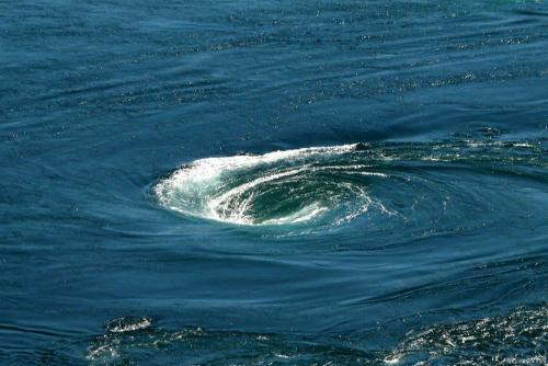
The ferry arrived shortly before 10 pm, and I drove here, arriving about 10 minutes after the maximum. The tide was going out, and only a few small whirlpools were forming. Apparently, the strongest tide and whirlpool occur with an incoming tide.
Drive to the Arctic Circle Monument at Saltfjellet
You can cross the Arctic Circle at Saltfjellet in Rana municipality by following the E6 from Mo i Rana for about 80 kilometres (50 miles). You will then come to the Arctic Circle Centre, at 650 metres (2,100 feet) above sea level, which has exhibitions, a souvenir shop and a cafeteria. In its cinema, you can watch the multimedia show ‘Welcome to the Arctic’, which presents fantastic images and music from the Arctic Circle region. The Centre also has its own post office, where all postcards are franked with the Arctic Circle postmark. You can also get your own Arctic Circle certificate. Note that the Arctic Circle Centre is closed during winter. I drove for about an hour, slept at a wayside and was driving towards Trondheim (about 700kms) at 6 am. Before hitting E6, at least 100 sheep were sleeping on the road in many groups – some obediently on the shoulder and many sprawled across the middle. They showed no interest in me and didn’t budge. But they were better than average-looking sheep – Norwegian sheep are quite cute.
After starting on E6 (the main highway through this part of Norway, pass through low forested mountains, along a dramatic river with great continuous waterfalls and rapids and then climb to a high treeless alpine plateau. I crossed the Arctic Circle at 7 am. The road was straight and flat, and I drove very fast. There are no radar cameras on this road. The road then goes through unexciting trees and at Rana, hits a large fjord. I had a nap at 9 to make up for my short sleep.
