
Ukraine – West Southern (Chernivtsi, Ivano-Frankivsk, Zakarpatiya)
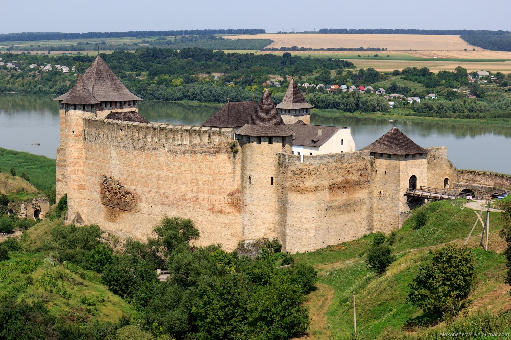
Khotyn Fortress (Sight).
History. In 1250-64, Prince Danylo of Halych rebuilt the fortress. They added a half-meter (20 in) stone wall and a 6-meter (20 ft) wide moat around the fortress. In the second half of the 13th century, it was rebuilt by the Genoese. Under the rule of Stephen the Great of Moldavia the fortress was greatly expanded. Under his leadership, new 5–6-meter (16–20 ft) wide and 40 meters (130 ft) high walls were built. He also added three towers and raised the courtyard by 10 meters (33 ft). This reconstruction brought the fortress to the structure it has today. During 14th-16th centuries the Fortress served as a residence to Moldavian Princes.
In 1476, the garrison successfully held the Fortress against the Turkish army of Sultan Mehmed II. By the end of the 16th century Moldavia became a tributary principality of the Ottoman Empire. During this time the Turks expanded and fortified the Fortress.
The Fortress was captured by the Polish-Lithuanian Commonwealth who undermined the walls of the Fortress, destroyed three towers and part of the western wall. After it was captured, the Khotyn Citadel was renovated between 1540-1544. In 1563 Dmytro Vyshnevetsky with five hundred Zaporozhian Cossacks captured the Fortress and held it for a time. It then changed hands several times between the Turks, Poles.
In 1621, the Commonwealth army (about 50,000 troops) successfully held off the army of Turkish sultan, Osman II (estimated at 100,000), in the Battle of Khotyn. On October 8, 1621 the Khotyn Peace Treaty was signed, stopping the Ottoman advance into the Commonwealth and confirming the Commonwealth-Ottoman border on the Dniester river.
In 1653, in the Zhvanets Battle on the left bank of Dniester, a garrison of Turks from Khotyn were fighting in the battle along with the forces of the Principality of Moldavia. In November 1673, the Khotyn Fortress was lost by the Turks: “More than 60 guns were thundering non-stop, the sky was in flames and smothered in smoke, the earth was quaking, the walls were groaning, the rocks were splitting into pieces. That which my eyes captured throughout the day was indescribable. It is impossible to convey the persistence and courage, or rather despair, with which both parties were fighting”.
With the 1699 Karlowitz Peace Treaty, the fortress was transferred from the Polish-Lithuanian Commonwealth to Moldavia. In 1711, Khotyn was again taken over by the Turks. The Turks then fortified Khotyn following a six-year (1712–18) reconstruction and it became the foremost stronghold of the Ottoman defense in Eastern Europe.
In 1739, after the Russians defeated the Turks in the Battle of Stavuchany (today Stavceane), they laid siege on the Khotyn fortress and surrendered the fortress to the Russians.
In 1769 and 1788, the Russians again successfully stormed the fortress, but every time it was given back according to peace treaties. Only after the Russo-Turkish War (1806-1812) did Khotyn become a permanent part of Russia and a district center in Bessarabia. However, when the Turks were retreating, they almost completely ruined the fortress.
In 1832, the new church of Oleksandr Nevskiy was built on the territory inside of the fortress. In 1856, the government ended the status of the Khotyn Fortress as a military entity.
In the First World War and the Russian Civil War took a heavy toll on the people of Khotyn. In 1918, Khotyn was occupied by 5 states: Russia, Ukraine, the Moldovan National Republic, Austria-Hungary, and Romania (latter in 1918). On July 6, 1941, Khotyn was again taken over by the German-Romanian armies. Khotyn was freed from the Axis on April 3, 1944. Today, Khotyn is one of the biggest cities and an important industrial, tourist, and cultural center of the Chernivtsi oblast.
There are also many legends about the fortress, created over the hundreds of years of its existence. Some popular legends involve the origins of the large dark spot on the side of the wall of the fortress. One legend says that the spot was created by the tears of the Khotyn rebels against the Ottoman Turks that were killed inside fortress. Another legend has it that the spot was created from the tears of a girl named Oksana, whom the Turks buried alive in the walls of the fort.
Pass through the moated bastion/gate house and walk down the hill past a church to this “fairy tale” castle on the banks of the Dnister River. It has great crenelated battlements, 3 small round guard towers and a large square tower all with restored conical roofs. Inside are several intact buildings. 60 UAH
CHERNIVTSI (pop 296,000)
Situated on the upper course of the River Prut, the Ukrainian part of the historical region of Bukovina. Chernivtsi is one of Western Ukraine’s main cultural centers and an important educational and architectural site. Historically a cosmopolitan community, Chernivtsi was once dubbed “Little Vienna” and “Jerusalem upon the Prut”. The city is a major regional rail and road transportation hub, also housing an international airport.
In 2001, the population of Chernivtsi was approximately 240,600 people of 65 nationalities. Among them, 189,000 (79.8%) are Ukrainians; 26,700 (11.3%) Russians; 10,500 (4.4%) Romanians; 3,800 (1.6%) Moldovans; 1,400 (0.6%) Polish; 1,300 (0.6%) Jews; 2,900 (1.2%) other nationalities.
History. n 1775, the northwestern part of the territory of Moldavia was annexed by the Habsburg Empire; this region became known as Bukovina. The city became the region’s capital, which in 1849 was raised in status and became known as the Duchy of Bukovina, a crownland of the Austrian Empire. The city received Magdeburg rights. The city began to flourish in 1778 when Knight Karl von Enzenberg was appointed the chief of the Military Administration. He invited many merchants, craftsmen and entrepreneurs to help develop trade and other businesses. Saint Peter’s Fairs ( 1–15 July) had given a new vibrant impulse to the market development from 1786. In the late 19th century the German language—due to the Habsburg and the very important Jewish influence—became the lingua franca and more and more newspapers were edited in German, also a remarkable literary production in German began in this period.In the late 19th century the German language—due to the Habsburg and the very important Jewish influence—became the lingua franca and more and more newspapers were edited in German, also a remarkable literary production in German began in this period.
During the 19th and early 20th century, Chernivtsi became a center of both Romanian and Ukrainian national movements. In 1908, it was the site of the first Yiddish language conference, the Czernowitz Conference, coordinated by Nathan Birnbaum. When Austria-Hungary dissolved in 1918, the city and its surrounding area became part of the Kingdom of Romania. In 1930, the city reached a population of 112,400: 26.8% Jews, 23.2% Romanians, 20.8% Germans, 18.6% Ukrainians, the remainder Poles and others. It was one of the five university centers of interwar Romania.
In 1940, the Red Army occupied the area; the area around the city became known as Chernivtsi Oblast, and was allotted to the Ukrainian SSR by the Soviet Union. The city’s large Romanian intelligentsia found refuge in Romania; while the Bukovina Germans were “repatriated” according to a Soviet-Nazi agreement. Under the regime of military dictator Ion Antonescu, Romania had switched from an ally of France and Britain to one of Nazi Germany; subsequently, in July 1941, the Romanian Army retook the city as part of the Axis attack on the Soviet Union during World War II. In August 1941, Antonescu ordered the creation of a ghetto in the lowland part of the city, where 50,000 Bukovina Jews were crammed, two-thirds of whom would be deported in October 1941 and early 1942 to Transnistria, where the majority perished. The Romanian mayor of the city Traian Popovici managed to persuade Antonescu to raise the number of Jews exempted from deportation from 200 to 20,000.
In 1944, when Axis forces were driven out by the Red Army, the city was reincorporated into the Ukrainian SSR. Over the following years, most of the Jews left for Israel; the city was an important node in the Berihah network. Bukovina Poles were also “repatriated” by the Soviets after World War II. The city became a predominantly Ukrainian one.
Chernivtsi province is in the NM “XL” series.
Chernivtsi Classical Architecture. The main architectural attractions of the city include: the Chernivtsi Drama Theater (1905); the Chernivtsi University—UNESCO World Heritage Site (1882); the Regional Museum of Fine Arts—the former savings bank (1900); the Regional Council—former Palace of Justice (1906); and the Chernivtsi Palace of Culture—former Jewish National House (1908); among many others. The magnificent Moorish Revival Czernowitz Synagogue was heavily damaged by fire in 1941, the walls were used to create the “Chernivtsi” movie theater.
The city of Chernivtsi has a lot of architecturally important buildings. Many historic buildings have been preserved, especially within the city’s center. However, after years of disrepair and neglect, the buildings are in need of major restoration.
As Chernivtsi was part of the Austro-Hungarian Empire, it was closely related to the empire’s culture, including architecture. Main architectural styles present within the city include Vienna Secession and Neoclassicism, Baroque, late Gothic architecture, and fragments of traditional Moldavian and Hungarian architecture, Byzantine architecture as well as Cubism. During the Interwar Romanian administration, a great number of buildings in the Neo-Romanian and Art Deco architectural styles were also built.The city is sometimes dubbed Little Vienna, because its architecture is reminiscent of the Austro-Hungarian capital Vienna.
Residence of Bukovinian and Dalmatian Metropolitans. A World Heritage Sites, it was built between 1864-82. This complex of large brick buildings is now the home to Chernivtsi National University.
The UNESCO citation, declaring the Residence and the buildings in its complex as of “outstanding universal value”, describes the site as follows: The architectural ensemble comprises the former Residence of the Metropolitans with its St. Ioan cel Nou of Suceava Chapel; the former seminary and Seminary Church, and the former monastery with its clock tower within a garden and landscaped park. The Residence, with a dramatic fusion of architectural references, expresses the 19th century cultural identity of the Orthodox Church within the Austro-Hungarian Empire during a period of religious and cultural toleration. In the 19th century, historicist architecture could convey messages about its purpose and the Residence of Bukovinian and Dalmatian Metropolitans is an excellent example.
The buildings of the complex are laid out on three sides of a courtyard which is approximately 100 metres deep and 70 metres wide: the fourth side of this yard contains the main gates, set in tall railings.
Opposite the gate is the largest single building, the residence of the Metropolitan, which also contains the Chapel of John the New of Suceava. The building presently houses the University’s Faculty of Modern Languages. It contains the Synodal Hall (today called the Marble Hall), with a painted ceiling. Other major rooms in this building include the former library of the Metropolitan (the Blue Hall), a smaller meeting space (the Red Hall) and the former reception room of the Metropolitan (the Green Hall). The UNESCO report on the site describes the Red Hall as “an extraordinary beautiful wooden jewel box, whose wall painting resembles a sophisticated trimming with red Chinese silk.”
To the left of the gate is the seminary building (the right wing of the ensemble) and its church, the Church of the Three Holy Hierarchs, which contains murals by Karl Jobst and other artists.
On the other side of the courtyard (the left wing of the ensemble), the former monastery building is today the geography department of the university. The clock tower of this building is decorated with Stars of David as a tribute to the Jewish community of Czernowitz which contributed to the construction of the complex.
The whole ensemble is set in an extensive landscaped park, which contains a monument to Hlávka sculpted in 1937.
The buildings were looted and considerably damaged by fire during World War II. After the war when the region came under Soviet control, the theological faculty was closed down; when the buildings began to be restored in 1955, they were transferred to the town’s university. In the intervening period, the buildings had been used for storage and many of the murals had been painted over. Internal redecoration, restoring some of the original features, was carried out from 1957 to 1967, when the ensemble was granted government protection. In 1991 the building was listed on the State Register of the newly independent Ukraine. Extensive restoration was carried out from 2004 onwards, resulting eventually in the ensemble being inscribed by UNESCO in its list of World Heritage Sites on 28 June 2011. The Residence was chosen in competition, including an Internet vote, as one of the Seven Architectural Wonders of Ukraine in 2011.
The buildings surround a treed courtyard on three sides. They are tall with decorative brick arches over the windows and a crenelated decorative brick roof lines. The roofs are blie/green/black geometric tile designs. Inside the entrances are 5 x 6 rows of domed aisles. I sat inside in the cool and mooched the free wifi (all my bookmarks in Google Maps disappeared!) Free

Bucovina Jewish History Museum. A one-room museum, it would be best to use the audioguide as the museum is mostly photos and short vignettes but not much history of the Jews in Bucovina. 16 UAH
In the late 19th century the German language—due to the Habsburg and the very important Jewish influence—became the lingua franca and more and more newspapers were edited in German, also a remarkable literary production in German began in this period.In the late 19th century the German language—due to the Habsburg and the very important Jewish influence—became the lingua franca and more and more newspapers were edited in German, also a remarkable literary production in German began in this period.
In 1908, it was the site of the first Yiddish language conference, the Czernowitz Conference, coordinated by Nathan Birnbaum. In 1930, the city reached a population of 112,400: 26.8% Jews, 23.2% Romanians, 20.8% Germans, 18.6% Ukrainians, the remainder Poles and others.
In August 1941, Antonescu ordered the creation of a ghetto in the lowland part of the city, where 50,000 Bukovina Jews were crammed, two-thirds of whom would be deported in October 1941 and early 1942 to Transnistria, where the majority perished.
Chernivtsi once had a Jewish community of over 50,000, less than a third of whom survived World War II. Romanian lawyer and reserve officer Theodor Criveanu, as well as the then city mayor Traian Popovici, supported by General Vasile Ionescu saved 19,689 Jewish people. Initially, Governor of Bukovina Corneliu Calotescu allowed only 190 Jewish people to stay, but Traian Popovici, after an incredible effort, obtained from the then dictator of Romania Marshal Ion Antonescu an allowance of 20,000. After World War II, the city was a key node in the Berihah network, which helped Jews to emigrate to the then Mandate Palestine from the difficult conditions after the War. Following the collapse of the Soviet Union in 1991, the majority of the remaining Jewish population emigrated to Israel and the United States. A famous member of this latter emigration is the actress Mila Kunis.
Chernivtsi Museum of Arts. A local artist, portraits from 1800s, prints and religious art. Most labels were in Ukrainian only. Upstairs, some ethnography, paintings from the 1900s, Easter eggs and carpets. Enjoyable museum. 30 UAH
Chernivtsi Oblast Museum (Bukovynian Diaspora Museum). This open-air museum has only a few houses arranged as small farms, all are thatched, plastered and have similar interiors: bed, large clay stove/oven, weaving, farm “implements”. There are several outbuildings like chicken coops, barns, summer kitchens, sod storage. There are also two fixed windmills. About half were open and could be seen insdie. 20 UAH
St. Paraskeva. Frescoed in fresh murals with a light blue background and with large clear glass windows, this church is bright and airy inside. Many gilt framed icons and gilt decorated marble iconoclast. The frescoes in the dome look original and are dark. Free
Aviation and Cosmonautics Museum. The unique museum of astronautics – the only one of its sort on the territory of Ukraine – is opened in Zhytomyr as Sergei Korolev – the talented scientist and engineer, the initiator of applied cosmonautics, the creator of Soviet space and rocket equipment, the person, whose ideas enabled the launching of the first artificial satellite, – was born and spent his childhood.
The rich museum’s exposition is located in two buildings. Its first part – memorial – is situated in the house, where the genius constructor was born, and tells about the principal stages of his life and work. The separate building was constructed for the main – cosmic – part of the exposition that tells relates the history of cosmonautics’ development. There are two rockets at the entrance. There are spacecrafts and equipment, many of which were in the open space, as well as life-size and maximally precise models of artificial satellites and Lunokhod. And documents, pictures, as well as personal belongings of the first conquerors of space and objects of orbital life are presented on the benches, originally put into shape of semi-transparent flying saucers. But the special pride of the museum’s creators is the capsule with soil from the Moon, presented by NASA.
Carpathian NP is a National Park located in Ivano-Frankivsk Oblast. The park was established on 3 June 1980 to protect landscapes of the Carpathian Mountains. The headquarters of the park are in Yaremche. Carpathian National Nature Park is the first national park of Ukraine and one of the biggest national parks of this country.
The area of the park is 515.7 square kilometres (199.1 sq mi), of which 3,834 square kilometres (1,480 sq mi) is the area where any economic activity is prohibited. The park is located in the highest part of the Ukrainian Carpathians, on the eastern slopes in the drainage basins of the Prut River and the Black Cheremosh River. The Prut has its source in the park, and the highest point of Ukraine, Mount Hoverla (2,061 metres (6,762 ft)), is located at the borders of the park. The lowest point of the park is about 500 metres (1,600 ft).
The landscapes in the park include Alpine meadows and forests. The three most common tree species in the park are silver fir, European beech, and spruce. The Huk Waterfall, located within the park, is the highest single-drop waterfall in the Ukrainian Carpathians (84 metres (276 ft)). There are two lakes of glacial origin.
The area of the Carpathian National Nature Park was historically inhabited by hutsuls and contains a number of monuments of history and architecture, including historical wooden buildings. It is actively used for tourism, with 48 maintained trails (as of 2012).
IVANO-FRANKIVSK
Ratusha. In the NM “Modern Architecture Buildings”, this is a high clock tower in Market Square, the Old Town part of the city. It is built in a wedding cake design with a big base, two more levels, then the clock, then a hexagonal tower with a brass top. The clock chimes on the quarter hours.
It is the only rathaus in Ukraine built in the Art Deco. The building is built in such way that from a top view it is reminiscent of the Polish order of Virtuti Militari (Military Valor).
During the installation of the foundation of the building’s south-eastern wing, workers installed a time capsule containing plans of the new design, photos of the old rathaus, and other documents. Initial plans had the construction finished in 1932, but, due to lack of financing, the construction continued until 1935, while decorative work continued until World War II.
The rathaus survived World War II. The building design represents a cross (the Order of Virtuti Militari). At the intersection of the cross rises a tower topped with a dome which is reminiscent of a military helmet. On the fourth floor at each corner were placed bronze eagles that represent the Polish state symbol (Orzeł Biały). During renovations in 1957 those “ideologically alien” creations were replaced with inexpressive sculptural decorations. The complete height of the rathaus is 49.5 m (162 ft), a height that at the time of construction made it the tallest structure in the city. Unlike the previous versions of the building, it was not used as a town hall, but rather as a symbolic representation of the past. The space in the building was leased to numerous stores which, after the “Golden September” (the Soviet term for the invasion of Poland in 1939), were closed.
During the Nazi occupation Hitler’s followers tried to destroy the building. However, they were unable to blow it up as the rathaus was built out of reinforced concrete. The Germans managed, however, to blow up its northwestern wing; they ran out of time to destroy the rest of the building. After the Soviet liberation the building was used as a warehouse. In 1957 the oblast Regional Administration financed a renovation project that continued until 1958. On April 26, 1959 the building opened as was a regional museum. On the bottom floor is a small archaeological display. Climb the stairs to the observation deck above the clock 20 UAH

Today I saw 8 people (mostly older women) leading a single cow along the highway. Walking the cow!
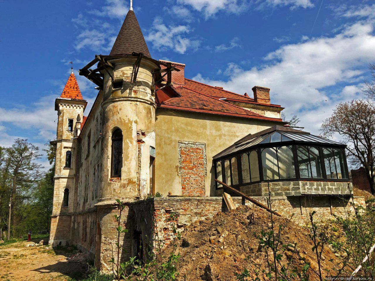
Palace of Yablonovsky-Brunitsky. Down a short gravel road blocked by a simple chain link fence, I could just barely see this manor house through the trees.
I could find nothing decipherable about it on Google except for some images.
GO TO UKRAINE – WEST NORTHERN
NOMAD MANIA Ukraine – West Southern (Chernivtsi, Ivano-Frankivsk, Zakarpatiya)
World Heritage Sites:
Primeval Beech Forests of the Carpathians and the Ancient Beech Forests of Germany
Residence of Bukovinian and Dalmatian Metropolitans (Chernivtsi National University)
Wooden Tserkvas of the Carpathian Region in Poland and Ukraine
Borders:
Hungary-Ukraine
Moldova ‘proper’-Ukraine
Poland-Ukraine
Romania-Ukraine
Slovakia-Ukraine
XL:
Podvir’ivka area (border with Moldova)
Veľké Slemence/Mali Selmentsi
Museums: Verkhovyna: Museum of Gutsulsk Magic
Castles, Palaces, Forts: Khotyn: Khotyn Fortress (Sight)
World of Nature:
Carpathian NP
Synevir
Uzhanian National
Waterfalls:
Maniava waterfall
Shypit
Zhenetskyi Huk
Ski Resorts: Bukovel
European Cities
CHERNIVTSI
World Heritage Sites: Residence of Bukovinian and Dalmatian Metropolitans (Chernivtsi National University)
Sights: Chernivtsi Classical Architecture
XL: Chernivtsi province
Museums:
Bucovina Jewish History Museum
Chernivtsi Museum of Arts
Chernivtsi Oblast Museum (Bukovynian Diaspora Museum)
Religious Temples: St. Paraskeva
Aviation Museums: Aviation and Cosmonautics Museum
IVANO-FRANKIVSK
Airports: Ivano-Frankivsk (IFO)
Modern Architecture Buildings: Ratusha
UZHHOROD
Museums: Jozsef Boksay Art Museum
Villages and Small Towns
IZA
KHUST
YASINIA
KOLOMYYA
Museums: Pysanka Museum
MUKACHEVO
Museums: Mihaly Munkacsy Memorial Museum
Castles, Palaces, Forts: Palanok Castle (Sight)
Religious Temples: Saint Nicholas Monastery