
I then started my journey to see the rest of Romania on June 7, the Southeast and Northwest before going to Moldava. My search for the butane tank and shower continues. I am going to stop cooking meals, eat out more, and have only salads for dinner. I can’t go without coffee.
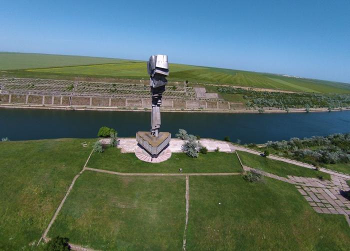
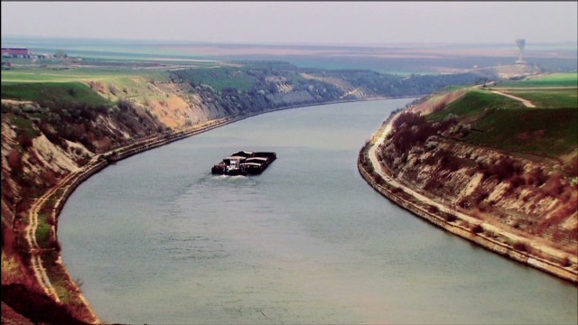
It was 200kms to Constanta on a fast 4 lane expressway. Maintaining speeds of 140-160kms/hour, the speedsters in the left lane were still breezing by me. I needed gas – the first station would not accept my credit card (that’s a first), I continued, turned off the highway to see the monument and then drove through several villages until I was almost empty until finally I found diesel. Now 25kms off course, it was several kms on narrow, rough gravel to reach the monument.
Statuia Tineretului (Monumental Tineretului Autor Pavel Bucur). Truly in the middle of nowhere surrounded by fields, this was a huge adventure getting to and leaving – but worth coming to for the remoteness and colossal size and construction of the monument. If I had not done the detours to get gas, Google Maps said it was 28kms from the turnoff from the expressway. Then on leaving, it was 3½kms to pass under the expressway (a big gas truck here asked if the road was passable in Romanian, the only vehicle I saw on the entire drive) and then another 5kms on rough, potholed gravel following the canal to pavement in the town of Murfatlar where I crossed the canal to continue to Constanta.
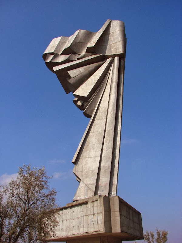
It sits on a small rise (supported by a retaining wall around the base) on the edge of a canal completely controlled with a cement wall and high terraces. It is accessed on gravel roads each way. The monument is a huge abstract construction of stainless steel/aluminum? plates set onto a reinforced concrete base – first a round 1m high, 10m diameter base, then a 2m high triangular piece and then a 4m high triangle that overlaps the first two. This has 56 pieces of rebar sticking out on each of the three sides that I guessed held a frieze but all that is gone. Then there is the metal structure on top.
Unfortunately graffiti covered a lot of the cement and they had even managed to get on top of the third overhanging piece (ladders) to graffiti the steel. The whole place is totally untended with weeds, grass and wild flowers growing out of all the cracks in the cement. Free
This is what I found on the internet about the monument:
The Monument of the Youth. On the banks of the Danube-Black Sea Channel, this monument was built by the Communist Youth League to remember the Romanians who constructed the Danube-Black Sea Canal, but also to symbolize freedom or flight to infinity. Thousands of political prisoners died during 1949-1955 construction of the canal as they were subjected to a extermination regime. The canal was the beginning of the works for the realization of the “fourth arm of the Danube”. It is a quasi-unknown monument, built near the former village of Straja.
Inaugurated in the late 1980s, the monument cost at the time a bridge, according to the artist who conceived it. Embodying a highly stylized angel without wings – an angel of freedom – the 50-meter high monument is the 35th highest statue of the world, though actually it is below sea level. After the Statue of Liberty, it was the highest monument in the world when it was raised.
It is erected on a ten-foot concrete socket with twelve columns fixed to a depth of 20 meters, and is made of stainless steel. The statue, without a socket, is 38 meters tall. Once, the base was adorned with massive bronze bas-reliefs, depicting episodes from the construction of the Canal. After the 1989 Revolution, the Youth Monument went into oblivion. In 2000, a band of entrepreneurial thieves armed with artillery removed the three bas-reliefs – bronze plates ranged from 14 to 19 tons, according to the artist. However, the Police report noted that the plates weighed five tons. Only some of these were recovered from a collection center in Calarasi County. The thieves also took the stainless steel plates at the base of the monument, as well as the bronze letters on the base that addressed the following message: “Future generations know that we have sacrificed ourselves for the ascension of the Homeland.”
The artist who created the monument, Pavel Bucur, “It’s a shame that’s going on. Today, no one cares for this colossus, which, if properly put to good use, could have its contribution in attracting tourists. An idea would be to restore and redecorate by placing new bas-reliefs. It is not normal for such an imposing monument to be left out! Just as the statue of Prometheus stands on the Vidraru Great Dam as well as the Monument of the Youth, “the angel with a broken wing” stands guard on the open waterway of the monumental human work of the Danube – Black Sea Canal.
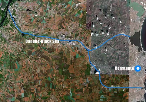
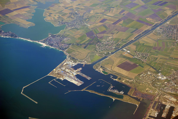
DANUBE-BLACK SEA CANAL (Canalul Dunăre – Marea Neagră) is a navigable canal in Romania, which runs from Cernavodă, on the Danube river to Constanța (1976-1984; 64.4kms, southern arm, the main branch), and to Năvodari (1983-1987; 31.2kms, northern arm), on the Black Sea. It is an important part of the European canal system that links the North Sea (through the Rhine–Main–Danube Canal) to the Black Sea. The Canal was notorious as the site of labor camps in early 1950s Communist Romania, when at any given time, up to 20,000 political prisoners worked on its excavation. The total number of people used as a workforce for the entire period is unknown, with deaths estimated at several thousand. These works were later used in the Carasu irrigation system.
Geography. The course of the canal follows mostly the course of the former Carasu River, originally a tributary of the Danube. It also conveys the runoff from a 1,031 km2 drainage basin to the Black Sea.
The main reasons for the building of the canal were to circumvent the Danube Delta, which is difficult to navigate, to shorten the distance to the Black Sea, and several issues related to the loading and unloading of ships.
In its delta, the Danube is divided into three main branches, none of which is suited to optimal navigation: Chilia branch is the deepest, but its mouths were not stable, which made navigation dangerous; Sulina branch is not deep enough for maritime ships to navigate on it and it also used to be isolated from the railroad system; Sfântu Gheorghe branch is shallow and sinuous.
It would also serve a secondary purpose, that of land reclamation – with the drainage of marshes in the area. Also during the construction period, the Danube – Black Sea Canal was advertised as a fast and direct connection between the Soviet Volga-Don Canal and Central Europe.
Dimensions. The 64.4 km (40.0 mi) main branch reduces the distance by boat from Constanța to Cernavodă by ca. 400 km. It has a width of 90 m and a depth of 7 m. The northern arm has a length of 31.2 km, width of 50 m and a depth of 5.5 m. The radius of its sharpest bends is 3 km (1.9 mi) for the main branch, and 1.2 km (0.75 mi), for the northern branch.
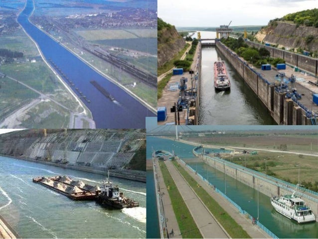
The waterway passes through the towns of Medgidia and Murfatlar, both of which have been turned into inland ports. It was designed to facilitate the transit of convoys comprising as much as six towed barges, up to 3,000 in tonnage each, 296 m in length and 22.8 m wide (ships of up to 5,000 in tonnage, as long as 138 m and with as much as 16.8 m in beam and 5.5 m in draft can also pass through the canal). The structure is bound by four locks (in Cernavodă and Agigea, and in Ovidiu and Midia, respectively).
In its final phase, the canal took over nine years to construct; 381,000,000 m3 (1.35×10¹⁰ cu ft) of soil were excavated (greater than the amount involved in building the Panama and Suez canals), and 5,000,000 m3 (180,000,000 cu ft) of concrete were used for the locks and support walls.
History. The earliest plans for building this canal were in late 1830s but were complicated by politics between Russia, Austrian and the Ottoman Empire and construction did not begin until 1949.
Prison camps sprang up all along the projected canal route in the summer of 1949 and were quickly filled with political prisoners brought from jails from throughout the country. These first arrivals were soon joined by newly arrested people who were sent to the canal in ever increasing numbers. By 1950 the forced labor camps set up along the length of the planned canal were filled to capacity; that year alone, up to 15,000 prisoners were held in those camps. By 1953, the number of prisoners had swelled to 20,193, though older estimates claimed figures as high as 60,000. One million Romanians had been imprisoned in various prisons and labor camps, including the Danube-Black Sea Canal.
The construction effort surpassed the resources available to the Romanian economy in the 1950s. The canal was assigned inferior machinery, part of which had already been used on the Soviet Volga-Don Canal, and building had to rely on primitive techniques (most work appears to have been carried out using shovels and pickaxes, which was especially hard in the rocky terrain of Northern Dobruja). Detainees were allocated to brigades, usually run by common criminals, which were encouraged to use violence against their subordinates. In parallel, the region’s industrialization, destined to assist in the building effort, was never accomplished.
Sums allocated for prisoners’ health, hygiene and nutrition declined dramatically over the years. Food rations were kept to a minimum, and prisoners would often resort to hunting mice and other small animals, or even consuming grass in an attempt to supplement their diet.
The prisoners were dispossessed farmers who had attempted to resist collectivization, former activists of the National Peasants’ Party, the National Liberal Party, the Romanian Social Democratic Party, and the fascist Iron Guard, Zionist Jews, as well as Orthodox and Catholic priests. The canal was referred to as the “graveyard of the Romanian bourgeoisie” by the Communist authorities, and the physical elimination of undesirable social classes was one of its most significant goals.
The Presidential Commission for the Study of the Communist Dictatorship in Romania presented an estimate of several thousand deaths among the political prisoners used in the project, significantly higher than 656 officially recorded by an official report from 1968. Journalist Anne Applebaum had previously claimed that over 200,000 had died in its construction, as a result of exposure, unsafe equipment, malnutrition, accidents, tuberculosis and other diseases, over-work, etc., while political analyst Vladimir Socor had estimated the number of deaths to be “considerably in excess of 10,000”. As such, the project became known as The Death Canal (Canalul Morții). It has also been called “a cloaca of immense human suffering and mortality”.
In parallel, authorities left aside sectors of employment for skilled workers – kept in strict isolation from all others, they were attracted to the site with exceptional salaries (over 5,000 lei per month), as well as for young people drafted into the Romanian Army and whose files indicated “unhealthy origins” (a middle-class family background). Their numbers fluctuated greatly (regular employees went from 13,200 in 1950 to 15,000 in 1951, to as little as 7,000 in early 1952, and again to 12,500 later in that year). At the same time, facilities meant to accommodate the projected influx of labor (including homes available on credit) were never actually completed. This was overlooked by the propaganda machine, which furnished Stakhanovite stories instead, according to which work quotas were surpassed by as much as 170%. Authorities also made the claim that the construction site was offering training to previously unskilled workers.
On July 18, 1953, the project came to a discreet halt, all work being suspended for another 23 years (according to some sources, the closure had been ordered by Stalin himself, as early as 1952). The canal camps remained in existence for another year, and their prisoners progressively relocated, to similar conditions at other work sites in Northern Dobruja. Penal facilities on the canal site were shut down in mid-1954.
Trial. Blame for the debilitating and unsuccessful works was eventually placed on a group of alleged conspirators, who were indicted in a show trial (late 1952) – they faced various trumped-up charges (espionage, fraud, sabotage). The inquiry was orchestrated by Iosif Chișinevschi. Three people were executed (the engine driver Nichita Dumitrescu, and the engineers Aurel Rozei-Rozenberg and Nicolae Vasilescu-Colorado); others were imprisoned for various terms. Defendants in a second group, around the engineer Gheorghe Crăciun, were sentenced to various harsh penalties (including three life imprisonments). Torture was applied by a Securitate squad led by Alexandru Nicolschi, as a means to obtain forced confessions.
Construction. In June 1973, the project, with a complete new design, was restarted by Nicolae Ceaușescu, who had previously ordered the rehabilitation of people sentenced in the 1952 trial, and who aimed to withdraw the Lower Danube from Soviet control (which had been consecrated by the 1948 Danube Conference). In official propaganda, where the 1950s precedent was no longer mentioned, the canal was referred to as the Blue Highway (Magistrala Albastră). New and large machinery, produced inside Romania, was introduced to the site. The southern arm was completed in May 1984, with the northern arm being inaugurated in October 1987.
The cost of building the canal is estimated to be around 2 billion dollars, and was supposed to be recovered in 50 years. However, as of 2005, it has a yearly income of only a little over 3 million euros.
L’ensemble rupestre de Basarabi (Basarabi Cave Complex). It is a relic of the widespread monastic phenomenon in 10th century Bulgaria. They are a complex of cells-dwellings, 4 small and 2 larger churches, crypts and tombs from the 9th-11th centuries. There are many inscriptions carved on the walls in Greek, Old Slavonic, 30 in Cyrillic, and 60 in Turkic. 10 Lei
It is interesting that this is where I arrived after driving all the lousy roads.
CONSTANTA
Museum of National History and Archaeology. On the huge, but empty main square, this mammoth building has archaeology from the 6th century BC, Greeks, Romans, Byzantines to the present. 20 Lei, 10 reduced.
Popular Art Museum (Folk Art Museum). First floor: 18th century painted glass, mostly religious scenes, traditional dress, icons, textiles. 2nd floor: ceramics, wonderful Moldava kilum rugs, weaving and traditional dress. 5 Lei
Romanian Navy Museum. This starts with amphorae and gets all mixed up with no chronological order. There’s the usual many boat models, uniforms, compasses and navigational instruments, guns and even gets into passenger boats and other civilian ships. I found some of the lighthouse bits nice with some giant fresnel lens. 20 Lei, 10 reduced
Acvariu Constanţa. This is all fresh-water fish mostly from the Amazon of South America and some Aftican fish mostly in smaller tanks and one large tank. The aquarium is on the water with an abandoned palace next and the massive port in the distance. 20 Lei Cathedral of Saints Peter and Paul (Catedrala Sfintiii Apostoli Petru si Pavel). With a façade of cement rectangles and light brick, the porch is frescoed with flowers, vines and birds and the usual saint. The inside likewise is completely frescoed with a painted curtain around the base. The chairs and altar are gilt. Free
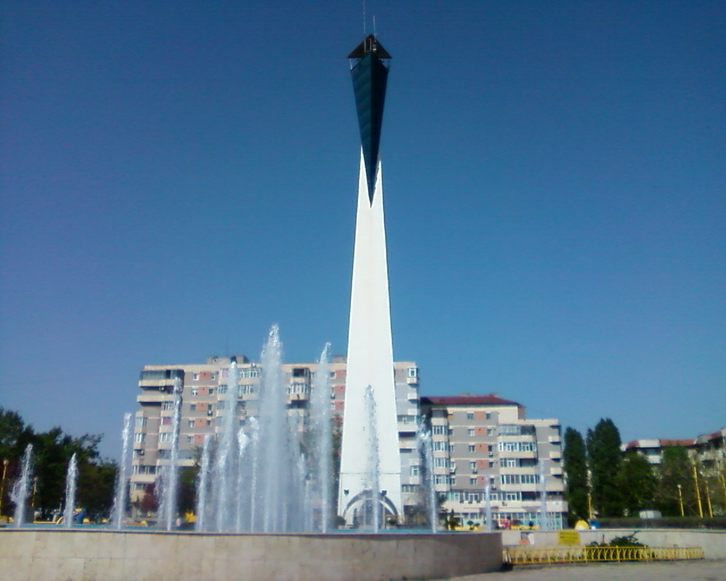
Constanța Lighthouse. Situated about 1km from the water in a round park with a fountain, this unusual lighthouse is a white square tapering to narrow top with a blue triangle coming down from above with the light and keepers room. Free
Mamaia Beach. East of Constanta, a long narrow strip of land separates the Black Sea from Lakes Siutghiol and it is all one long beach on the Black Sea side. This is tourist heaven for Romania. The beaches have millions of umbrellas, small thatched palapas, beach bars, hotels, resorts and I assume millions of tourists in the summer. The sand is an odd mixture of dirt, sand and shells.
It was then a 100km drive to Tulcea, on the Danube Delta and the far southeastern corner of Romania.
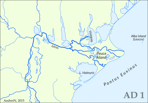
DANUBE DELTA
The Danube Delta (Romanian: Delta Dunării) is the second largest river delta in Europe, after the Volga Delta, and is the best preserved on the continent. The greater part of the Danube Delta lies in Romania (Tulcea County), with a small part in Ukraine (Odessa Oblast). Its approximate surface area is 4,152 km2, of which 3,446 km2 is in Romania. With the lagoons of Razim–Sinoe (1,015 km2 with 865 km2 water surface), located south of the main delta, the total area of the Danube Delta is 5,165 km2. The Razim–Sinoe lagoon complex is geologically and ecologically related to the delta proper and the combined territory is listed as a World Heritage Site.
Geography and geology. The modern Danube Delta began to form after 4000 BCE in a bay of the Black Sea, when the sea rose to its present level. A sandy barrier blocked the Danube bay where the river initially built its delta. Upon filling the bay with sediment, the delta advanced outside this barrier-blocked estuary after 3500 BCE, building several successive lobes: the St. George I (3500–1600 BCE), the Sulina (1600–0 BCE), the St. George II (0 BC–present) and the Chilia or Kilia (1600 CE–present). Several other internal lobes were constructed in the lakes and lagoons bordering the Danube Delta to the north (Chilia I and II) and toward the south (Dunavatz). Much of the alluvium in the delta and major expansion of its surface area in the form of lobes resulted from soil erosion associated with the clearing of forests in the Danube basin during the 1st and 2nd millennium. Probably 40 percent of the Delta was built in the last 1000 years. Finding that was like a eureka moment.
At present the delta suffers from a large sediment deficit, after the construction of dams on the Danube and its tributaries in the later half of the 20th century. However, construction of a dense network of shallow channels in the delta over the same period attenuated the deficit on the delta plain but increased erosion along the coast. The Danube Delta is a low alluvial plain, mostly covered by wetlands and water. It consists of an intricate pattern of marshes, channels, streamlets and lakes. The average altitude is 0.52 m, with 20% of the territory below sea level, and more than half not exceeding one meter in altitude. Dunes on the most extensive strand plains of the delta (Letea and Caraorman strand plains) stand higher (12.4 m and 7 m respectively). The largest lakes are lakes Dranov (21.7 km2), Roșu (14.5 km2) and Gorgova (13.8 km2).
Distributaries of the Danube. The Danube branches into three main distributaries into the delta, Chilia, Sulina, and Sfântul Gheorghe (Saint George). The last two branches form the Tulcea channel, which continues as a single body for several kilometers after the separation from the Chilia. At the mouths of each channel gradual formation of new land takes place, as the delta continues to expand. Chilia, in the north, the longest, youngest, and most vigorous, with two secondary internal deltas and one microdelta in full process of formation at its mouth (to Ukraine).
Sulina, the central and thus the shortest arm, which consequently led to its extensive use for traffic and severe transformation. At its mouth is located the main port and a single settlement with urban characteristics of the Romanian part of the delta. Because of the alluvium deposited at its mouth, a channel gradually advancing into the sea (presently it has 10 km) was built in order to protect navigation.
Sfântul Gheorghe (Saint George in English), in the south, is the oldest and most sparsely populated. Its alluvium has led to the creation, beginning in 1897, of the Sacalin Islands, which today measure 19 km in length.
Climate. The climate of the Danube Delta is continental, with strong influences from the vicinity of the Black Sea and its prevalent amphibian environment. It is the driest and sunniest region of Romania.

Main ecosystems. The Danube Delta falls within the Pannonian steppe ecosystem of eastern Europe, with Mediterranean influences. As a young region in full process of consolidation, the Danube Delta represents a very favourable place for the development of highly diverse flora and fauna, unique in Europe, with numerous rare species. It hosts 23 natural ecosystems, but due to the extent of wetlands an aquatic environment is prevalent; a terrestrial environment is also present on the higher grounds of the continental levees, where xerophile ecosystems have developed. Between the aquatic and terrestrial environments is interposed a swampy, easily flooded strip of original flora and fauna, with means of adaptation to water or land, depending on the season or hydrological regime. At the contact between freshwater and sea water, some special physical, chemical and biological processes take place, which have led biologists to consider this area as a very different ecosystem called beforedelta. Musura Gulf, north of Sulina, and Saint George Gulf are considered the most representative of this type of ecosystem.
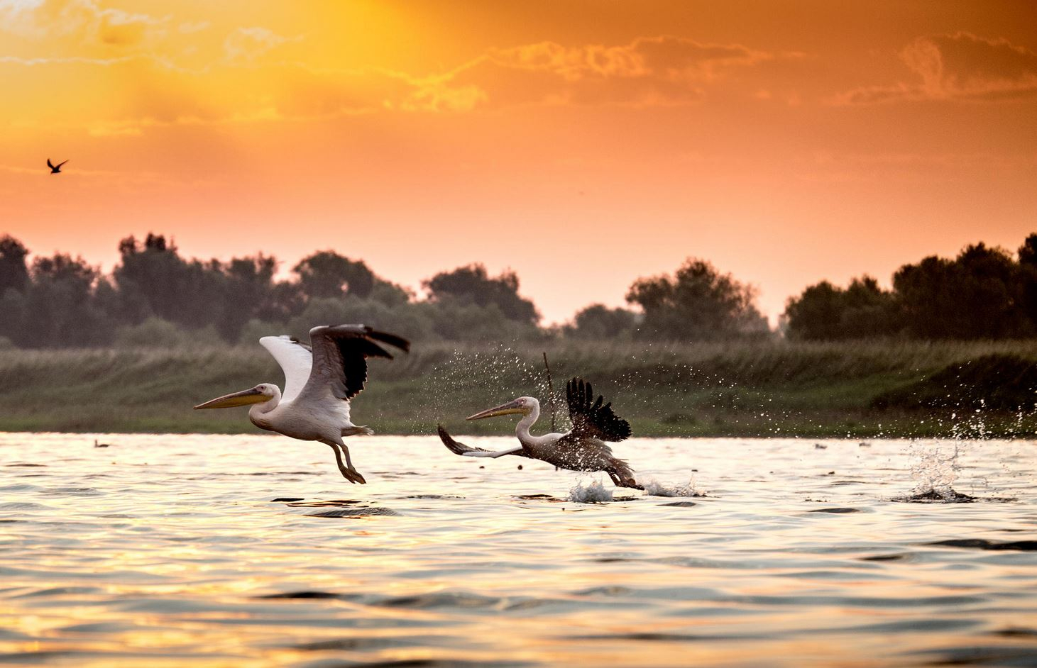
Situated on major migratory routes, and providing adequate conditions for nesting and hatching, the Danube Delta is a magnet for birds from six major ecoregions of the world, including the Mongolian, Arctic and Siberian. There are over 320 species of birds found in the delta during summer, of which 166 are hatching species and 159 are migratory. Over one million individual birds (swans, wild ducks, coots, etc.) winter here.
Ecosystem of running water. This comprises the arms of the Danube, and a series of its more important streamlets and channels. It is an environment rich in plankton, worms, molluscs, grubs, and sponges, with numerous species of fish, such as the carp, pike, pike perch, sheat-fish, and freshwater sturgeons (sterlet, Vyza and Danube mackerel).
Ecosystem of stagnant water. This environment includes the lakes, and various ponds, streamlets and channels. It is characterized by a rich floating and submerse flora. Of the fish, the most important are Tench, common bream, common rudd, Prussian carp, wels catfish, European perch, and northern pike.
Ecosystem of marshy and flooding areas. Reed plants and floating reed islands are the most common and well known components of the Danube Delta. They provide ideal spawning and nesting grounds. The plaur are a mixture of reed roots, grass and soil, usually floating or anchored to the riverbed. As a rule, the reed surrounds the lakes and ponds, and slowly invades the water surface.
This type of ecosystem is noted for its variety and large population of birds, some of them very rare. The most important are the tufted duck, red-crested pochard, mallard, greylag goose, pygmy cormorant, purple heron, great white egret, little egret, eurasian spoonbill, great white pelican, Dalmatian pelican, mute swan, and glossy ibis. A recent and welcomed newcomer is the pheasant.
Among the mammals, there is the Eurasian otter, European mink, little ermine, wild boar, and wild cat, in winter the hare and, on the brink of disappearing from the delta, the wolf and the fox. The East Asian raccoon dog, bizam/introduced muskrat, and to some extent South American nutria, are recent species that have successfully adapted.
River bank and levee ecosystems. The firm land of the delta used to be covered with large groves of willow trees, which have been cut down almost entirely and replaced with Canadian poplars. On the river banks kept in their natural state, small groves of willow trees can still be found, mixed with white poplar. Occasionally, the willow trees form corridors along the arms and bigger channels of the Danube. On the levees of Letea and Caraorman, mixed forests of oak with various trees, shrubs, and vines grow on sand dune areas. On the Letea levee, these exotic-looking forests grow especially in the depressions between the sand dunes, in small groves called hasmace. Fauna of this region include the meadow viper, osprey, and Eurasian eagle owl.
Inhabitants. The Danube Delta is perhaps the least inhabited region of temperate Europe. On the Romanian side live about 20,000 people, of whom 4,600 live in the port of Sulina, which gives an average density of approx. two inhabitants per km2. The rest of the population is scattered among 27 villages, of which only three, all situated marginally, had more than 500 people in 2002. The city of Tulcea, at the western edge of the delta, has a population of 92,000 (in 2002); it represents the node of the region and the gate to the delta.
Its acute isolation and harsh conditions of living, based mainly on subsistence, made the Danube Delta a place of emigration, or transit at least. Very few of those born in the region stay there through adulthood; at the same time, the origins of its inhabitants vary widely, as people from many parts of Romania can be found in the delta. The total population has remained more or less constant throughout the 20th century; there were 12,000 inhabitants in the 1890s, and 14,000 before the Second World War. Romanians account for approximately 80% of the population, and Ukrainians for 10%. Other people living in the delta include ethnic minorities such as Greeks, Turks and Bulgarians (in 1992). Distinctive to the region, but very rare as an ethnic entity, are the Lipovans, descendants of the Orthodox Old Rite followers who fled from religious persecution in Russia during the 18th century.
On the Ukrainian side, located at the northern edge of the delta, the town of Izmail has a population of 85,000, Kiliya a population of 21,800, and Vilkovo, the main center of the Lipovan community, a population of 9,300.
Environmental issues. Large-scale works began in the Danube Delta as early as the second half of the 19th century. First corrections of the Sulina arm began in 1862, and they continued throughout the 20th century. As a result, the length of the Sulina arm was reduced from 92 to 64 km, and its flow more than doubled, thus making it suitable for large-vessel navigation. Correcting the six large meanders on its course thereby reduced the length of the Sfântu Gheorghe from 108 to 108 km, and its flow also increased somewhat. Both these increases were made to the detriment of the Chilia arm, which at present remains the most unspoiled arm of the main three. These corrections, as well as the digging of various secondary channels throughout the body of the delta, have had a serious impact on the ecosystem. Natural environments have been altered, the breeding pattern of fish has been disrupted, and the flows in the main arms have increased, with serious consequences regarding the discharge of alluvia and the erosion of banks.
Reed was intensively harvested during the Communist era. The regime had plans to transform the delta into a large agro-industrial zone. Although the first modern agricultural exploitation dates from 1939, only after 1960 were large areas drained and converted, to the detriment of the wetlands. In 1991 agricultural land in the delta surpassed 100,000 hectares, and more than a third of its surface has been affected by crop cultivation, forest plantation, or pisciculture. As a result of these changes, along with the increasing pollution and eutrophication of the waters of the Danube, and decades of exploitation and poor fishing regulations, the fish population has been visibly reduced.
In 2004, Ukraine inaugurated work on the Bistroe Channel that would provide an additional navigable link from the Black Sea to the populous Ukrainian section of the Danube Delta. However, because of the negative impact which this new channel might have on the fragile ecosystem of the delta, the European Union advised Ukraine to shut down the works. Romanian officials threatened to sue Ukraine at the International Court of Justice. Under the presidency of Kuchma, Ukraine had responded that Romania was only afraid of the competition that the new channel would bring, and continued working on the channel. Under the presidency of Yuschenko, who visited Romania in 2005, both sides agree that professionals should decide the fate of the channel. In the long run, Ukraine plans to build a navigation channel, if not through Bistroe Channel, then through another channel.
The Danube-Black Sea Canal was built to circumvent the Danube Delta, which is difficult to navigate, to shorten the distance to the Black Sea, and several issues related to the loading and unloading of ships.
In its delta, the Danube is divided into three main branches, none of which is suited to optimal navigation: Chilia branch is the deepest, but its mouths were not stable, which made navigation dangerous; Sulina branch is not deep enough for maritime ships to navigate on it and it also used to be isolated from the railroad system; Sfântu Gheorghe branch is shallow and sinuous.
TULCEA
Danube Delta Aquarium and National Park Visitor’s Center. The aquarium in the basement has most fresh water fish (including pike, perch and the Danube catfish that can grow to 5m and weigh 300-400kgs) plus a few tanks of tropical fish. Upstairs there are many life-like dioramas of delta creatures, mostly a lot of stuffed birds but a surprising number of mammals that are rarely seen. 20 Lei, 10 reduced
Sulina Lighthouse of the European Commission of the Danube. This is only accessible by boat. All day trips from Turcea (10am-7pm) cost €55.
The drive was along the Danube, initially delta then big farm country on a good two-lane road with no traffic and few towns. To get to Galati, there is a ferry (20 Lei) over the Danube, here a big wide channel. She argued that I had a minibus. The ticket booth was a ways back and you couldn’t buy on the ferry.
GALATI
History Museum (Paul Paltanea Museum). The regional museum has the usual, archaeology and ethnography in 3 floors. It is amazing how little one learns about the actual town in these museums. 10 Lei, 5 reduced.
Then it was a long 4 hours to Iaşa on narrow two-lane roads through rolling farm land. The road improved to wide two-lane for the last 130kms.
NOMAD MANIA Romania – Southeast (Constanţa, Tulcea, Brăila, Galaţi, Buzău)
World Heritage Sites: Danube Delta
Tentative WHS: L’ensemble rupestre de Basarabi (Basarabi Cave Complex) (01/03/1991)
Islands: Great Brăila
Borders:
Bulgaria-Romania
Moldova-Romania
Romania (sea border/port/river)
Romania-Ukraine
Lighthouses: Sulina Lighthouse of the European Commission of the Danube
Beaches: Mamaia Beach
Caves: Movile Cave
Festivals:
Anonimul International Film Festival
Sunwaves Festival
MANGALIA
Museums: Mangalia: Muzeul de Arheologie Callatis (Museum of History and Archaeology Callatis)
Lighthouses: Mangalia Lighthouse
Beaches: Vama Veche Beach
European Cities
BUZAU
FOCŞANI
BRAILIA
Museums: Braila Museum
CONSTANTA World Cities
Museums:
Museum of National History and Archaeology
Popular Art Museum (Folk Art Museum)
Maritime/Ship Museums: Romanian Navy Museum
Aquariums: Acvariu Constanţa
Religious Temples: Cathedral of Saints Peter and Paul (Catedrala Sfinti Apostoli Petru si Pavel)
Lighthouses: Constanța Lighthouse
Monuments: Statuia Tineretului (Monumental Tineretului Autor Pavel Bucur)
Maritime/Ship Museums: Romanian Navy Museum
GALATI World Cities
Railway, Metro, Funiculars, Cable Cars: Galați Trams
Museums: History Museum ??(Paul Paltanea Museum)
DANUBE DELTA
World Heritage Sites: Danube Delta
XL: Danube Delta (Tulcea)
Danube Delta National Park (Delatadunaril). There are no roads accessing specific parts of the park.
TULCEA
Musuems: Danube Delta Aquarium – Visitors Centre for Danube Delta National Park. 20 Lei, 10 reduced
