
Romania – Centre (Brasov, Şibiu, Alba, Mureş, Covasna, Harghita) May 28-June 3, 2019
ȘIBIU (pop 170,000)
Sibiu is a city in Transylvania located 275 km north-west of Bucharest. The city straddles the Cibin River, a tributary of the river Olt. Now the capital of Sibiu County, between 1692 and 1791 and 1849–65 Sibiu was also the capital of the Principality of Transylvania.
Sibiu is one of the most important cultural centres of Romania and was designated the European Capital of Culture for the year 2007, along with the city of Luxembourg. Formerly the centre of the Transylvanian Saxons, the old city of Sibiu was ranked as “Europe’s 8th-most idyllic place to live” by Forbes in 2008. The city also administers the village of Păltiniș, a ski resort located 35 kilometres to the south.
History. Sibiu was initially a Daco-Roman city called Cedonia. The town was refounded by the Saxons (German) settlers brought there by the king Géza II of Hungary. The first reference to the area was Cipin and Cibinium from 1191 when Pope Celestine III confirmed the existence of the free prepositure of the Saxons in Transylvania, the prepositure having its headquarters in Sibiu.
In the 14th century, it was already an important trade centre. In 1376, the craftsmen were divided in 19 guilds. Sibiu became the most important ethnic German city among the seven cities that gave Transylvania its German name Siebenbürgen (literally seven citadels). It was home to the Universitas Saxorum (Community of the Saxons), a network of pedagogues, ministers, intellectuals, city officials, and councilmen of the German community forging an ordered legal corpus and political system in Transylvania since the 1400s. In 1699, after the Ottomans withdrew to his base of power in Hungary and Transylvania, the town became capital of Principality of Transylvania (since 1570 the principality was mostly under suzerainty of the Ottoman Empire, however often had a dual vassalage). During the 18th and 19th centuries, the city became the second- and later the first-most important centre of Transylvanian Romanian ethnics. The first Romanian-owned bank had its headquarters here (The Albina Bank), as did the ASTRA (Transylvanian Association for Romanian Literature and Romanian’s People Culture). After the Romanian Orthodox Church was granted status in the Habsburg Empire from the 1860s onwards, Sibiu became the Metropolitan seat, and the city is still regarded as the third-most important centre of the Romanian Orthodox Church. Between the Hungarian Revolution of 1848 and 1867 (the year of the Ausgleich), Sibiu was the meeting-place of the Transylvanian Diet, which had taken its most representative form after the Empire agreed to extend voting rights in the region.
After World War I, when Austria-Hungary was dissolved, Sibiu became part of Romania; the majority of its population was still ethnic German (until 1941) and counted a large Romanian community, as well as a smaller Hungarian one. Starting from the 1950s and until after 1990, most of the city’s ethnic Germans emigrated to Germany and Austria. Among the roughly 2,000 who have remained is Klaus Johannis, the current President of Romania.
Geography. Sibiu is situated near the geographical center of Romania set in the Cibin Depression, the city is about 20 km from the Făgăraș Mountains, 12 km from the Cibin Mountains, and about 15 km from the Lotru Mountains, which border the depression in its southwestern section. The northern and eastern limits of Sibiu are formed by the Târnavelor Plateau, which descends to the Cibin Valley through Gușteriței Hill.
The Cibin river as well as some smaller streams runs through Sibiu. The geographical position of Sibiu makes it one of the most important transportation hubs in Romania with important roads and railway lines passing through it.
Climate. Sibiu’s climate is humid continental with average temperatures of 8 to 9 °C (46 to 48 °F). The average rainfall is 627 l/m2, and there are about 120 days of hard frost annually.
Demographics. It is the 14th-largest city in Romania. The ethnic breakdown is Romanians 95.9%, Hungarians 1.6%, Germans (Transylvanian Saxons) 1.1%, Roma 0.4%. Today, most of the population is Romanian Orthodox (90%). Protestants and Roman Catholics represent about 5%.
Economy. Sibiu is an important economic hub for Romania, with a high rate of foreign investments. It is also an important hub for the manufacturing of automotive components and houses factories belonging to ThyssenKrupp Bilstein-Compa, Takata Corporation, Continental Automotive Systems, and NTN-SNR ball bearings. Other local industries are machine components, textiles, agro-industry, and electrical components (Siemens).
The Historic Centre of Sibiu and its Ensemble of Squares. A tentative WHS: (29/06/2004), the Upper Town is organised around three city squares and a set of streets along the line of the hill. The buildings are an interesting mix of styles (mostly Baroque and Gothic), colours and roof lines. The main street in the center is Str Nicolae Bălceseu, wide and pedestrianized.

Grand Square, the largest square, has been the center of the city since the 15th century. At 142 meters long and 93 meters wide, it is one of the largest ones in Transylvania.
Brukenthal Palace, one of the most important Baroque monuments in Romania, lies on the north-western corner of the square. It was erected between 1777 and 1787 as the main residence for the Governor of Transylvania Samuel von Brukenthal. It houses the main part of the National Brukenthal Museum, opened in 1817, making it one of the oldest museums in the world. Next to the palace is the Blue House or Moringer House, an 18th-century Baroque house bearing the old coat of arms of Sibiu on its façade.
On the south and east sides are two- or three-storey houses, having tall attics with small windows known as the city’s eyes. Most of these houses are dated 15th to 19th centuries, and most of them are Renaissance or Baroque in style.
Lesser Square is a smaller square situated in the northern part of the Upper Town. After the 2007 rehabilitation there has been an increase in the number of small businesses such as pubs and restaurants in this area. The square is connected to the other two squares and to other streets by small, narrow passages. When I was here, there was a lovely band playing music – all wind instruments and drums.
Brukenthal National Museum (Samuel von Brukenthal Palace) is a museum housed in the palace of Samuel von Brukenthal, the first Habsburg governor of Transylvania. He started its first collections around 1790 and opened to the public in 1817, making it the oldest institution of its kind in Romania.
It is a complex of six museums in different locations around the city. The Art Galleries are located inside the Brukenthal Palace with about 1,200 works of 15th to the 18th century European painting: Flemish-Dutch, German and Austrian, Italian, Spanish and French Schools. The Galleries also include collections of engravings, books, numismatics, and minerals. The temporary exhibition was “Decade of Romanian Art”.
The Brukenthal Library, also inside the Brukenthal Palace, has 300,000 manuscripts, rare foreign books, old Romanian-language books, contemporary books and specialized magazines. 25 lie
The Museum of Pharmacology is located in an historical building dated 1569, where one of the oldest pharmacies in present-day Romania was located. It is the basement of this house where Samuel Hahnemann invented homeopathy.
Orthodox Metropolitan Cathedral (Holy Trinity Cathedral). This Roman Catholic parish cathedral was built between 1726-33. A single nave structure, it has lovely side chapels with polychromes. The 1901 stained glass windows were paid for by donations from local families. The apse has a nice 1777 fresco of the Holy Mother crowned by the Holy Trinity. Mass is held in three languages. Free
Astra National Museum Complex. Located 4kms west of the city center in a lovely mature forest, this open-air museum has 2 sections. Unfortunately it is poorly signed and I saw only the traditional folk house section with several log buildings with thatch or shingle roofs. The signs are poor and tell little of the origin of the homes but most were relocated here from the region. The most interesting were the church, a Roma camp and a water-wheel driven sawmill. Most were locked but you could enter the ground stone foundation sections with no furniture. The second part circles a large lake with several water and wind driven mills, municipal buildings and sheep enclosures. 25 Lie, 12 reduced and free for me today as I arrived 50 minutes before closing.
I had not realized that Romania was an hour ahead of the Balkans and had the wrong time. But it is often worthwhile coming to museums just before closing – I get to enter many for free
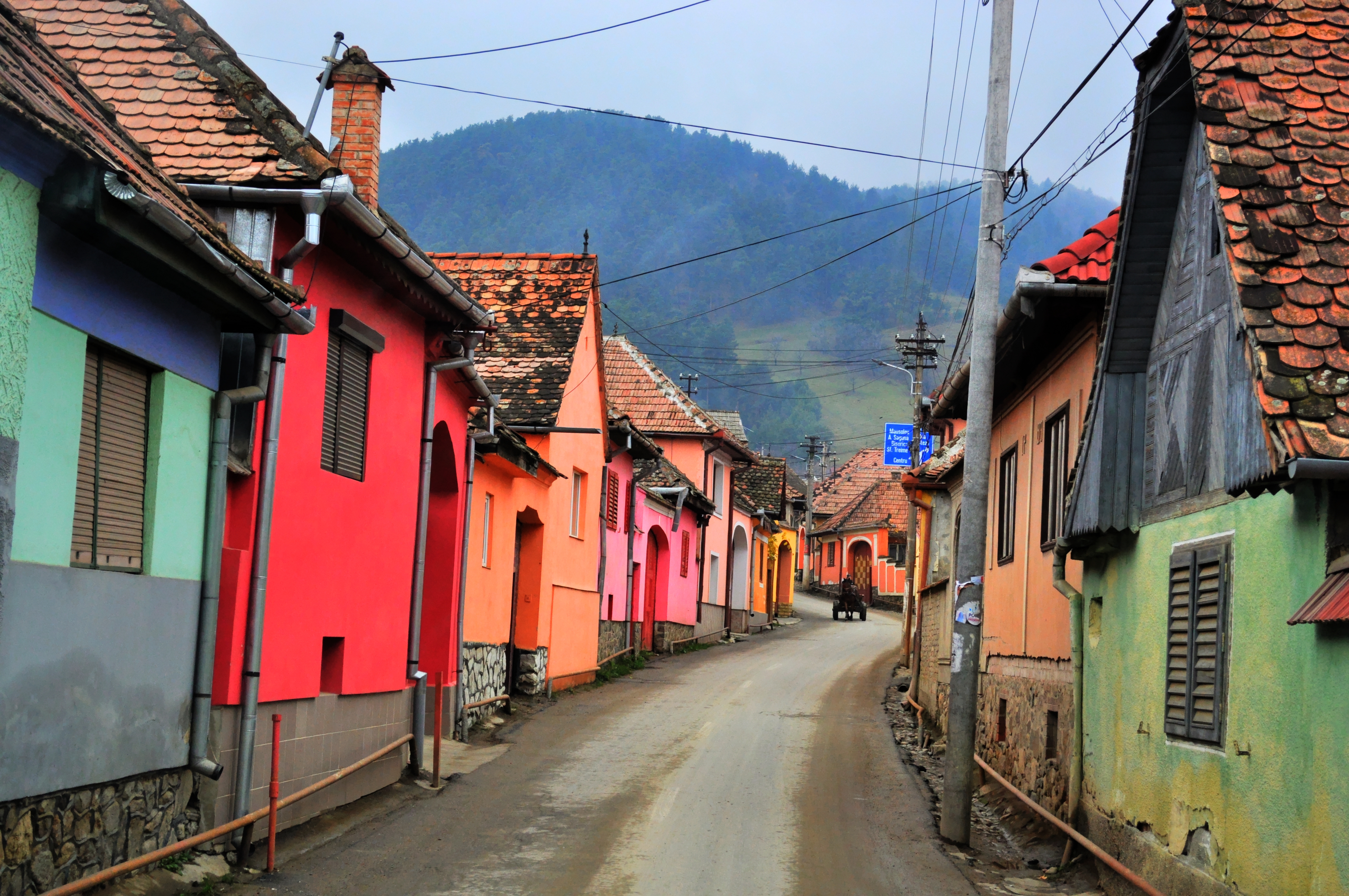
MARGINIMEA SIBIULUI VILLAGES (Traditional villages around Sibiu). In the NM “small towns” and “Sights” series, this area has 18 Romanian villages and small towns, each with a unique ethnological, cultural, architectural, and historical heritage. The area is situated in the immediate vicinity of the cradle of Saxon Civilisation in Transylvania – the city of Sibiu, and has an area of over 200 km² limited by the Sadu River in the south and the Sălişte river in the north. The villages are situated around the valleys of different rivers that flow from the Cindrel Mountains through the Transylvanian Plateau.
I visited these first three, the oldest of the 18.
Rășinari. Now this is a cute village. The pastel painted houses line the narrow streets forming a continuous line of buildings. Each house has a large, arched wood door (like a garage door but with doors in it) that gives access to parking and the house. There are at least 3 churches, one with a massive graveyard and a lovely municipal building housing the museum.
Orlat. Not nearly as cute as Răsinari, the gates to the parking aren’t in walls but simpler and lower iron gates.
Tălmaciu (town). This is larger and has more 2-story houses. I slept here on the side of the river in a great spot.
The others are: Boița, Fântânele, Sibiu, Galeş, Gura, Râului, Jina, Poiana Sibiului, Poplaca, Râul Sadului. Rod, Sadu, Săliște (town), Sibiel, Tălmăcel, Tilișca and Vale.
Brief history. The oldest known settlement was a Saxon village called Ruetel dating to 1204 – which became Rășinari in 1488 -, followed by Tălmaciu (1318), Orlat (1322) and Săliște (1354). Throughout their history, some were fiefs of the rulers of the Romanian principality of Wallachia. An important event was the establishment in the 18th century by Maria Theresa of the 1st Romanian border regiment at Orlat. Boița was also a border village, at the end of the passageway along the Olt River.
Occupations. The people were mainly shepherds crossing the Carpathian Mountains connecting communities to the north and south of the mountains. Activities closely related to shepherding, such as wool and leather manufacturing, are still well maintained in the area today.
The Transalpine Highway starts in Talmaciu and runs west over the spine of the mountains.
ALBA JULIA
Le noyau historique de la ville d’Alba Julia. A tentative WHS (01/03/1991).
The main square has several bronze status of “normal” town folk and a Roman site with a lapidarium full of stone fragments. The citadel, cathedral and museum are also in this area along with municipal buildings.
National Museum of the Union. This archaeology museum has Stone Age to modern history with a concentration on Roman artifacts. 10 Lei, 5 reduced
Citadel Alba Carolina. This massive star-shaped fort with many ravelins and bastions, is full of modern buildings (including a medieval hotel and restaurants), a Roman fort and houses and several halls (Weapons, Knights, Roman Vestiges), a prison and a military camp – the north east section is visited on what they call the Three Fortifications Route. 20 lei
Coronation Cathedral (Reunification Cathedral). Built in 1921-22 for the coronation of King Ferdinand I and Queen Mary on Oct. 22, 1922 as sovereigns of Romania, it is a Greek cross style supported by four massive marble columns. The highlights are the frescoes on the walls and mosaics in the apse. I entered during service – much chanting by the elaborately clad priests and lots of crossing and bowing by the congregation. The church is in in a large compound entered through a gate in the monstrous bell tower and surrounded by colonnaded portals.
I saw Alba Julia on my second day in Romania after Sibui, continued to West Romania and returned here from the northwest part of the country.
Castle Bethlen-Haller (Cetatea de Baltă). Originally built in French Gothic style by Gabriel Bethlen, the Prince of Transylvania in 1615-21, it was restored in 1770-73 in Baroque style by Eugen Haller. It was used by the state for the second half of the 20th century and then converted into a winery. Tours are only for groups by reservation.
The 3-story, square castle has large round corner towers with high peaked orange tiles roofs. Its walls average 1.25-2.4m thick.
VILLAGES WITH FORTIFIED CHURCHES IN TRANSYLVANIA
The south-eastern Transylvania region in Romania currently has one of the highest numbers of existing fortified churches from the 13th to 16th centuries. It has more than 150 well-preserved fortified churches of a great variety of architectural styles (out of an original 300 fortified churches).
Listed as a UNESCO World Heritage Site, Villages with Fortified Churches in Transylvania are seven villages (six Saxon and one Székely) founded by the Transylvanian Saxons. They are dominated by fortified churches and characterized by a specific settlement pattern that has been preserved since the Late Middle Ages.
The seven villages listed are Biertan, Cáinic, Dãrjiu, Prejmer, Saschiz, Valea Viilor and Viscri
History. The Saxon villages of Transylvania appeared in the twelfth century when the Kings of Hungary settled German colonists in the area. They had a special status and managed to survive and thrive, forming a very strong community of farmers, artisans and merchants. Being situated in a region constantly under the threat of the Ottoman and Tatar invasions, they built fortifications of different sizes. The most important towns were fully fortified, and the smaller communities created fortifications centered on the church, where they added defensive towers and storehouses to keep their most valuable goods and to help them withstand long sieges.
Description. The topography in Southern Transylvania is that of a plateau, cut by wide valleys of various small rivers that flow into larger ones, namely the Olt River, Mureş River, Târnava Mare River and Târnava Mică River. The villages follow the topography closely and try to make the best of it; thus villages situated in a valley developed around a central street and possibly some secondary ones, while those situated on a flatter spot follow a looser, radial pattern. Due to security reasons and the traditions of the Saxon inhabitants, the villages are compact.
The main element is the church, always situated in the middle of the town. Different types of fortifications can be found: a small enceinte around the church, a row of fortifications around the church or a real fortress with multiple fortification walls centered on the church. The churches have been adapted to include defensive functions; all of them are either Romanesque basilicas or single-nave churches of the late Gothic period. The churches often include many additions, ranging in age from the original period in which the churches were built Late Middle Ages to the sixteenth century. Many churches also include baroque elements from that period, as the baroque style was very popular in the region.
In almost all cases, the church is situated in an easily defendable position, generally on a hilltop. Elements of fortifications found in the main cities in the area have been adapted here, and they are a testimony of the building techniques used along the years by the Saxon community. Some fortifications had observation towers, some of them being church towers adapted to the needs of a fortress. The materials are the traditional ones, stone and red bricks, with a red clay tiled roof, a typical feature of the area.
Close to the church there is the main square of the village or Tanzplaz (Dance Square) to which social life gravitated. The only buildings situated next to the fortifications are those of communal use: the school or the village hall. The parish house, along with the houses of the most wealthy villagers, were situated around this square. Also in most sites, barns for grain storage are situated close to the centre of the village.
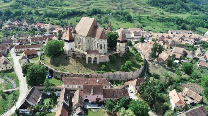
Biertan Fortified Church. Walk up a long wooden stairs inside the buttressed outer walls, covered with a wood roof, and cross through the main defensive walls. Two large towers are on the corners. One had 9 carved grave slabs, one with original paint.
The church is huge with side aisles the same height as the main nave, all with rib vaulted ceilings and supported by 6 massive columns. The iconostasis is a simple gilt frame system holding 18 icons. The highlights are the intricate inlay choir stalls, simple wood bench pews, intricately carved pulpit canopy, and oak wood floors. A simple marble baptismal font is in the center of the altar area. It is light filled from all the high, clear windows made of light round panes. 10 Lei, no reduction
I entered as 100s disgorged from a bus.

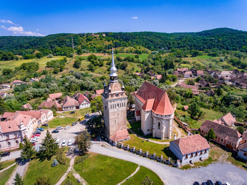
Fortified Stone Church of St Stephen, Saschiz . This is completely different – it has no walls and is simply a 10-story square, stone tower about 20m on a side. The roof has coloured tiles and 4 small turrets around the central steep spire. It was being renovated, was covered in scaffold, had a fence around it and the storyboard could not be read. The normal parish church was next door. Free
XL: Harghita and Covasna counties (majority Hungarian-speaking)
SIGHISOARA
This medieval fortified town sits on top of large hill. Pay for everything here.
Historic Centre of Sighişoara. This is a World Heritage Site. I parked at the bottom and walked up the long wooden steps to enter the walls with many guard towers. Continue up the rough river-rock cobble, turning right to the graveyard and church, at the highest part of Cetajil Hill. At the end I came down the road.
Church on the Hill, Sighișoara (Biserica Evangelical Din Deal). It has 3 naves, a bell tower and unusually a crypt (low, dark, brick with a domed vault ceiling, there are 60 niches, 58 of which are cemented over, one with a reliquy, and one with a bunch of wood). The original church was 13th century and restored in the 14th and 15th centuries. The hall dates from 1480-1500. The southern portal from 1428 has 4 statures presenting the Adoration of the Magi. Paintings date to 1380-1520. Dedicated to Saint Nicholas the church also has stone Gothic furniture and tabernacle, 1523 pews and several tombstones from 1500-1650. 8 Lei.
I was all alone inside. The frescoes are mostly gone and faded, but a few are still good. The wood chests are for storing food. Free
Then I walked down the 179 covered steps to the town square. A trio of pan flute, violin and guitar was playing in the square.
The History Museum (Muzeul De Istorie Sighisoara). In the 13th century, high clock tower, there are pots, axe heads and a great scale model of the old town. On the second floor are fascinating medical instruments for amputations and obstetrics from the 1800s. Climb the 113 wood stairs to the top of the tower. The clock mechanism is interesting. Small plaques show the distance to several cities in Europe and around the world: New York 7400, Beijing 7000, Tokyo 8890, and Sydney 15,500. 15 Lei
Medieval Weapon Museum. Lots of swords, armour, old guns, cannon balls and things to bludgeon people with. 6 Lei
VISCRI. In the NM “small towns” series, this was a 13km detour (great road until one enters the town when it becomes pot-hole gravel, then rough cobble up to the church), one I made only to see the Fortified Church of Viscri. The walls are white plastered with a central entrance tower. There are 4 large areas on top of the walls – one is a small museum in one of the towers. It tells of the villages storing their lard and ham in the tower because it was cool all year long. They were allowed access to get their ham once a week and controls measures to ensure honesty were strict. Another room had tools (carpentry, locksmith) and a loom and spinning wheel. At the very top is an open air “attic” with wattle bee hives and the large wooden chests used to store food.
When I was there, a classical trio was playing to a packed audience in the quaint small church, plain except for the faux-marble wood fronting the balcony. Free
On the drive to Fagaras, I came through rural country over some low hills. There were at least 40 bee “trucks”, large trucks filled with hives ~ 70-80 boxes per truck. They must follow the flowers but I could see few flowers.
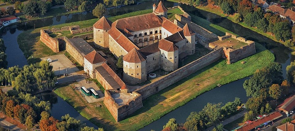
Fagaras Fortress, Fagaras. Dating from the 14th century, it was the residence of the Princes of Transylvania and the administration headquarters of Fagaras area. After 1696, it was a occupied by the Austrian army and between 1948-1960, it was a Communist prison.
On an island surrounded by a moat, this large fortress had an outer wall and inner fortified palace. Enter the courtyard and see the 16th century jail with more examples of torture techniques, the Black Tower built by the rulers of Wallachia in the 16th century. The big museum starts in the Bronze Age. Some of the interesting objects were the Roman parade mask, some gorgeous rooms, glass from Porumbacu de Sus, the round Thomory Tower, and a discussion of cutlery for the table. 15 Lei, 7 reduced
Brancoveanu Monastery, Sambata de Sus. I drove around the tiny town looking for the monastery but it was another 10kms to the south. Built in 1696 by the Walllachian Prince Constantin Brancoveanu (1688-1714) it was painted in 1766-67 but demolished by Austrians in 1785 and became a ruin; This magnificent monastery and church was built in 1926-36 and restored in completely in 1985 giving it a completely “new” look. Enter the large carved wood gate and then the large courtyard with the small church in the middle with carved columns and dark frescoes. The large church is a wonder of frescoes with a blue background. With 3 domes, a grand carved wood iconostasis and chairs, it is an opulent sight.
I then had a grand waste of time. Instead of turning east to go to Brasov, I decided to go to Bicaz gorge and Lacul Roşu (Red Lake) via a high pass through the snow-capped mountains of Cheile Bicazului-Hășmaș National Park. After about 25kms, most up many switch backs, the road was blocked. The German motorcyclists said that the road doesn’t usually open until June 30 because of snow. I camped near the large waterfall and decided to head to Brasov, as I should have done originally.
BRAȘOV
Brasov Architectural Ensemble. I walked through a lot of old Brașov, a real mixture of all architectural styles. See it all around the large central square.
Museum of Urban Civilisation. The present exhibition was “From Sinai to Jerusalem”, Architecture and Sacred Space, a photography exhibit by Teofil Mihailesou. 20 Lei 10 reduced.
Black Church. The originally-Roman Catholic structure was known as the Church of Saint Mary built in the 14th century. According to popular legend, a German child was disturbing the Bulgarian builders or told them that one of the walls was leaning. An annoyed Bulgarian pushed the child off the church tower and then immured his corpse in the church to conceal his crime.
The Catholic services were replaced with Lutheran ones during the Protestant Reformation. The structure was partially destroyed during a great fire set by invading Habsburg forces on the April 21, 1689 (during the Great Turkish War). Afterwards, it became known as the Black Church.
Biserica Neagră is 89 meters in length and 38 meters wide. It measures 65 meters from the floor level to the highest point of its only bell tower. The Black Church has a six-ton bell, the biggest in Romania, as well as a rich collection of “Transylvanian” rugs some of which are said to have been used to decorate walls as well as floors after the Reformation.
Much of the outside structure was built in friable grit, which caused outer sculptures and masonry elements to deteriorate with time. The cathedral is a major symbol of Brașov, and a museum is open to visitors. A Lutheran service is held each Sunday for the small German community in the city.
Rope Street Museum. This is a tiny museum downstairs with some old pictures of Brasov and a scale model of the old town. Upstairs are some great photography of the surrounding area and Brasov (a lot of it at night) and some nice nudes. 5 Lei
Capra Neagră Cable Car. About 10kms east of Brasov, drive up on several switchbacks to this lift to the top of the ski hill in the winter. It was not running the day I was there (very rainy, ugly day, but it probably only operates in the summer months. There were several tourists here wanting to go.). 20 Lei both ways.
Râșnov Citadel (Cetatea Rasmpv), Răsnov. This is both a NM “castle” and “sight.
There was a 1st century BC Dacian Fortress here (Comidave) with wood palisades and ditches around the rocky peak that was abandoned when the Romans conquered the Dacians. The present fortress dates from the 14th to the 17th century with the Saxons and had 80 houses. There is an amazing 146m deep well. After the 18th century, it lost its purpose and was abandoned.
Access is by a tractor pulled lalrge carriage (5 Lei). I happened to arrive just as a big load was going up. The first stop was at the “Dino Park” and the load of kids (everyone else) got off. Enter through the lower wall at a reconstructed tower and walk up to the castle to the round barbican. There are several intact quaint houses, most knick-knack shops and several fake cannons. The only reason to come here are for the views over the ruined north walls. 12 Lei, no reduction
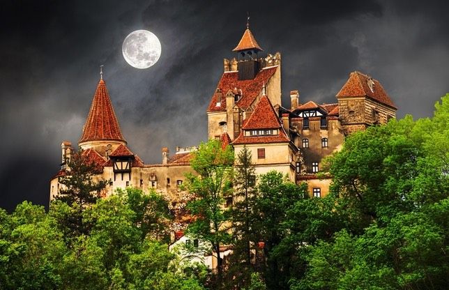
BRAN
Bran Castle. This castle was originally built in 1377-82 to defend the customs house and commercial roads passing through the Bran gorge and connecting east and west parts of this region. It was built by the townsfolk of Brasov at their own expense. The castle had 15-40 soldiers mostly English mercenaries and also served as a quarantine point. The Ottomans controlled it in 1541, but returned it to the Brasov community in 1651 but reverted to the Hapsburgs in 1691. It ceased being a customs point in 1836. From 1920-37, it was a royal residence and home to Queen Marie (encouraged Romania to join the Allies in WW I) who renovated it completely and the home of Princess Ilena (married to Anton Hapsburg, the Archduke of Austria and their 6 children from 1944-48. They fled the country for Argentina in 1948, moved to Newton Moss, USA in 1950 and she became a Romanian Orthodox nun in 1967. It was a state owned Communist museum during the Communist era and returned to the family after 1990. Ilena’s three children now own it and converted it into a tourist attraction.
The Irish writer, Bram Stoker invented the imaginary Dracula, a Transylvanian count in 1897. It was based on the image of the 15th century Wallachian prince, Vlad Tapes, famous for his cruelty (son of Vlad the Impaler). Romanian folklore has a tradition of the living dead.
It has been renovated beautifully with wood floors, Gothic arched ceilings, wood beamed ceilings, ceramic stoves and period furniture. Follow the long lines of tourists through a maze of narrow stairways and rooms.

This is the busiest tourist attraction in Romania. Try to arrive before the tour buses.
Bran Village Museum. The entrance is just opposite the ticket booth for the castle. It has only a few plaster and log relocated houses with period furniture, artifacts and traditional dress. Despite the nearby hoards of tourists, this was empty except for me. 4 Lei
After seeing Romania West, Northwest Northeast and Center regions, I returned to the south of Romania on June 3 from Bran. The drive was through the nicest part of Romania. The road was high above an impossibly green landscape of conifers and green fields with storybook villages and homes in the steep valleys below. It took 1½ hours to drive 50kms on the very windy road.
