
North Macedonia – Pelagonia and West – April 11, 2019
Currency. On xe.com in May 2019, 1€ = 61.59 MKD (Denars). 100 MKD = 1.62€
As I had time to kill before having to be at the Istanbul Airport on April 15, I decided to see more of the north of Greece, detour through Albania and then see some of the west of North Macedonia.
The Albania/North Macedonia border at the south end of Ohrid Lake was painless except for the final “inspection” when the old guy would not stop asking about drugs “cocaine, marijuana, joints, smoke?”. This was the same treatment I got when I left Albania to enter Greece (and the only other time this had happened). It seems Albanian border personnel assume us Western folks are all drug users.
Galicica National Park. This 25,000-hectare national park sits between Lake Ohrid and Prespa Lake. Elevations: Lake Ohrid 693m, Prespa Lake 850m, Mt Kota 2265m, Magaro Peak 2134m. Geologically it is composed of igneous silicates overlaid by 500-550m of limestone. 30 underwater springs and 15 coastal springs feed the two lakes. It has a high biodiversity with 1100 plant species, mostly grasses and several endemic animals. Its highlights are the St Naum Monastery, the Church of the Mother of God of Zaun Steke and the archaic site of Golem Grad on an island in Prespa Lake.
Saint Naum Monastery. Just a few kilometres north of the Albanian border on the shores of Lake Ohrid, this is a major commercial enterprise based primarily on the 10th century St Naum Church: 24 souvenir stalls line the entrance road, a convenience store, several restaurants around the springs (even boat rentals) and a swank restaurant and hotel that forms the front of the monastery. The landscaping is lovely with the highlight of two enormous cedar trees.
The church is a tiny stone/brick square with a dome above the entrance and a high dome in the church, all covered with ancient, fading frescoes. The altar screen is gilt. Free

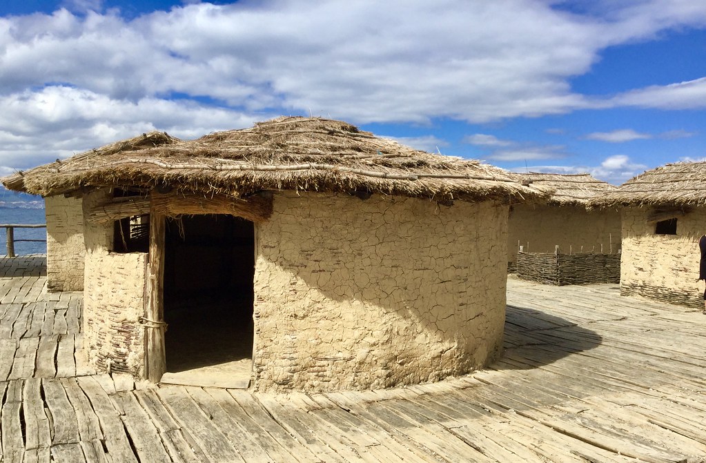
Bay of Bones Museum (Museum on the Water), Peshtani. This is a bay in Ohrid Lake and an archaeological site of prehistoric settlement on the peninsula. The depth is 3 to 5 meters. The place has been named “Plocha Micov Grad” and today there is a reconstruction of the endowed living quarters. Above it, there is a renewed Roman fortification (castrum) with military facilities from that time. This pile-dwelling settlement that has been erected was in the past spreading at a total surface of 8.500 m2. Bay of the Bones is an authentic reconstruction of a part of the settlement, dating back to between 1200 and 700 BC. This is a “village” of 20 wattle/plaster tiny houses with thatch roofs on a wharf on pilings over the water. It is connected to the shore by a small wood bridge. 100 MKD (€2)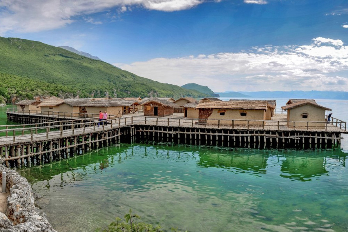
OHRID
Natural and Cultural Heritage of the Ohrid Region is a World Heritage Site. A long stone wall sits on the ridge at the back of town leading up to Samuel’s Fortress on the west end. Cross the parking gate and pay for the amount of time you think you need to see the Old Town. The houses may be old but are all completely renovated and look of recent construction. Pearls are big business in this town.
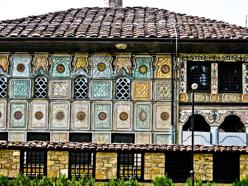
National Ohrid Museum (Robevci House, Robev Family House). This 1863-64. four-story, half-timbered house sits near the waterfront of Old Ohrid. The merchant Robev brothers, Konstantin lived on the left side and Antonas lived on the right of this house representative of Old Town architecture from the 19th century. It is the “city museum” with Greek and Roman stone remnants, several homemade carpets on the walls, furniture, religious vestments, lace, embroidery, weapons, jewelry, pots, Roman glass and bronzes, coins and much more. The 4th story is a grand “meeting room” with an ornately carved table with dragons for legs, chairs, ceiling and built-in cabinets. 100 MKD or €2.
Church of St. Sophia. Also near the water, this 1018 stone/brick church is a barrel-vaulted building with 2 aisles and faded frescoes on the back wall and side walls, and frescoes in better shape in the presbytery. The new marble altar looks out of place. At the back are bleachers facing the 2-story arched “theatre”.
From this church skirt the sheer cliffs on a rough wood walkway built above the water, through tiny lanes behind houses and past restaurants to access
St John the Theologian Church (Sveti Jovan Kaneo). This tiny stone/brick church sits on a rocky outcrop at the very west end of the Old Town. Unfortunately, it was closed and doesn’t look like it is often open, maybe because it is too long a walk from the busy part of Old Town.
I walked back to my car in 14 minutes from here and drove to try to access the fort from the north. Google Maps insisted on several tiny lanes so I parked at the bottom and walked the long way up to the fortress. There is a good road and a parking area just before the Old Town’s fortified wall, but it is still a jaunt up to the fort. In retrospect, the best way here is to continue from St John the Theologian up through a park and end up at the fort, then walk back down through the whole of the Old Town from above. The entire adventure would take about 2 hours (I see museums very rapidly).
Samuel’s Fortress (Samoil’s Fortress): On the highest hill forming the west boundary of the Old Town, the original fort dates to the 4th-5th centuries. In the 10th and 11th centuries, it was the seat of the Kings of Macedonia. When the Eastern Goths were a threat, the Slavic Kingdom headed by Tsar Samuel built the citadel. It was destroyed and rebuilt many times and last renovated in 2002.
The crenellated ramparts have great walkways. The only reason to come up here is for the views, the fort is simply an empty shell. 60 den or €1.
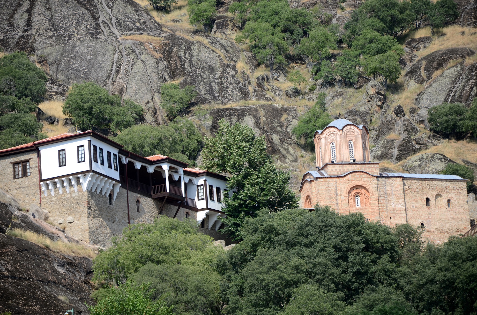
Sveti Jovan Bigorski Monastery (Bigorski Monastery St John the Baptist)
It was then an hour+ drive to Bitola through Pelister NP.
Pelister NP.
BITOLA
A disheartening thing about Bitola is all the casinos and sports betting houses. They are everywhere.
Sacred Heart of Jesus Catholic Church. In the heart of downtown Bitola on the main pedestrianized street, this lovely small church was built in 1856 with French government funding. It has been renovated many times after damage in WWI, the Balkan Wars and when the Turkish arsenal blew up. The blue, ribbed vaulted ceiling is supported by 5 nice marble columns on each side. The highlights are the intricately carved altar and the several polychrome images.
The church was getting a thorough cleaning by two young men from the 150-strong congregation and a gregarious nun. Most of the congregation are originally Croats, Serbians and Slovenians. The nun asked me if I was Catholic. When I told her I was an atheist, she said “So you worship money?”
St. Dimitri Church. Near the centre, this stone/brick Greek Orthodox Church was built in 1830, a typical example of Macedonian churches of the period. It has a porch on each side, then descend a few steps down to enter the side of the church. The imposing gilt altar screen crosses the entire width of the church. The plain white walls have several gilt-framed icons, the oldest from 1711 from St Naum. There are nice marble columns, a lovely balcony around three sides and a great ceiling painted blue with clouds surrounding Jesus. National Institute for Preservation of Monuments of Culture, Museum Bitola. This museum is a real hodge-podge of everything: archaeology (prehistory, Stone Age, Roman to modern), art fashion, ethnology, wars, guns, a list of all the Jews from Bitola sent to Treblinka, the concentration camp in Poland, and a large on room on Ataturk, the first president of modern Turkey who went to school in the building when it was a military high school. €2
Heraclea Lyncestis, Just 2½kms south of Bitola, this Roman ruin has ruined walls and some standing columns, but little of interest. 120 MKD
I then crossed back into Greece to finish seeing the far east of the country that borders Turkey.
North Macedonia – Pelagonia and West May 5-7 2019
I crossed the Bulgarian/North Macedonian border at 17:30 on May 5, 2019. It was painless on both sides. N Macedonia is easily the least problematic border to cross in the Balkans. I entered the extreme southeast of the country and saw both of these waterfalls (actually in North Macedonia north and east.
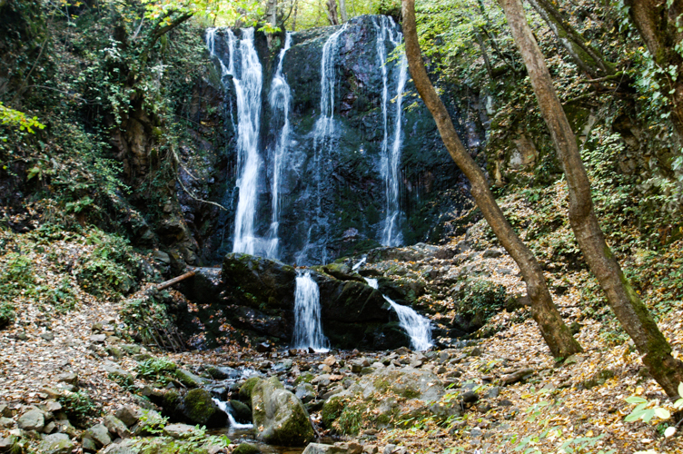
Smolare Falls. Only 11 km from the Bulgarian border, this is the highest waterfall in Bulgaria at 39.5m. It is on the Lemnitsa River deep in Mount Belasica at 630m elevation. After a day of rain, there was reasonable water flow.
Park and walk through the Atlantis Restaurant to start the trail. It is 550m long, a climb on good stone steps. The waterfall falls down a black granite face with white veining. There is no pool. I saw five gorgeous salamanders along the trail – a deep black, four with bright orange spots and one with bright yellow in a twisting strip along its back and spots.
Unfortunately, all the 14 or so garbage cans along the trail were overflowing with garbage strewn on the ground. Unbelievable. They should remove the cans and put up signs like “Pack it in, Pack it out”.
Koleshino Waterfall. About 10 km west of Smolare, this 16m high waterfall is a wide cascade down mossy cliffs. The short 5-minute trail goes through a nice forest with many picnic tables and the same pile of garbage.
PRILEP
The Memorial Museum October 11, 1941. During WW II, the Axis powers invaded the Kingdom of Yugoslavia. October 11, 1941, is the day the Yugoslav communists in Vardar began to organize an armed insurrection against their Bulgarian occupiers with an attack on the local police station in Prilep. This launched the war for national liberation from fascist occupation, which coincided with the subsequent rise of the Macedonian communist resistance movement in the following years. It lasted until late 1944. It is a national holiday in Macedonia.
The glorification of the Communist Partisan movement became one of the main elements of post-war Yugoslav political propaganda. The very Macedonian nation, state and language were the result of Yugoslav communist policies. Since Macedonia gained independence in 1991, the picture has not changed significantly. It is all a myth as the Bulgarian army entered Vardar Macedonia on April 19, 1941, and was greeted by the locals as liberators. In the October 11 attack, only a local policeman was killed. Soon after most of the leading pro-Yugoslav communists were annihilated or arrested and imprisoned until the 1944 Bulgarian coup d’etat. The resistance movement then fell virtually under Bulgarian communist control. Through 1942 and 43, the resistance was weak and sporadic and the Macedonian partisans were not a significant military force.
The Holocaust Museum in Scopje gave a slightly different story explaining the role some Jewish citizens who had escaped being sent to Nazi concentration camps played in the resistance movement.
The above is from Wikipedia and is a significantly different story than what is presented in the museum. 60 Den
Google Maps directed me to the Monument of the Partisans south of the city but could not find a route to it. That is because the location was total fiction. I drove several kilometres searching for a way but there was none because it does not exist here but is near the city of Krushevo, 30kms away.
Markovi Kuli (24/06/2004). This has so many locations, it became confusing. Google Maps initially placed it about 25 km east of Prilep on the top of a mountain. The Prilep locals referred to it as the rocky summit north of town where there is a large steel frame cross and a ruined fort, part of a complex built by the Slavs in the 10th and 11th centuries.
UNESCO refers to it as a granite and gneiss rocky mass estimated to be 720 million years old. It has many shapes resulting from erosion into fissures, faults and bending producing peaks, bare rocks, columns, spurs, mushrooms, balls, caverns and passage recesses. Part of it backs the Monastery St Archangel Michael.
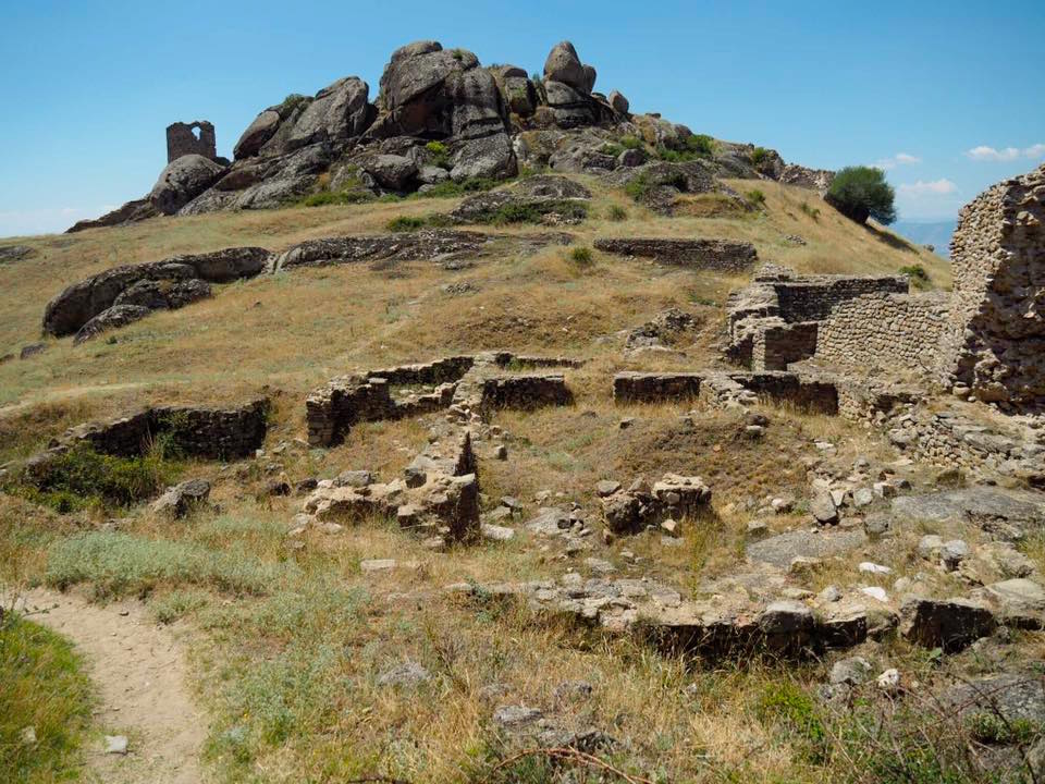
I drove to the north side of Prelip and started to walk toward the ruins. I was directed to a very rudimentary “path” that looked rarely used by an older guy, walked a few hundred metres on it and then turned around. The best access is from the monastery.
There is also a Markovi Kuli Nature Preserve on Vado Mountain outside of Skopje.
Monastery of St Archangel Michael. Built into the cliffs of the St Marko’s Towers in NW Prelip (part of Markovi Kuli tentative WHS), this first had a church here in the 10th century, was rebuilt in the 11th century, the 13th (the part in the tunnel under the present church) and most recently in 1861-2. There are some faded frescoes on the walls and is otherwise unremarkable. A nun unlocked the door to let me have a look but only after I covered my legs “God is here”. Five nuns reside in the monastery. Free
KRUSHEVO
This city is at the top of a mountain, the highest town in North Macedonia at 1350m. It is officially bilingual (Macedonian and Aromanian, an Albanian dialect). Historically it was controlled by the Byzantines (twice), Bulgaria, Serbia and the Ottomans. During the Ilinden Uprising in 1903, the rebels proclaimed the short-lived Krusevo Republic and the city was almost completely destroyed by the Ottomans.
Tose Proeski Memorial House. Tose Proeski (1981-2007) was a Macedonian multigenre singer, songwriter and actor popular across the Balkans and a top act of the local Macedonian and Balkan music scene. He was born in Prilep and grew up in Krusevo, He played the keyboard, guitar, piano, saxophone, clarinet, bass guitar and drums and made 7 albums. He was dubbed the Elvis Presley of the Balkans by BBC News. He held several humanitarian concerts was awarded the Mother Theresa Humanitarian Award in 2003 and became a UNICEF ambassador. He died at age 26 in a car crash (of a broken neck at C3 when the car he was a front seat passenger in struck the back of a truck) on the Zagreb-Lipovac A3 Highway near Nova Gradiska Croatia. He was given a state funeral and the football stadium in Skopje was renamed the National Arena Tose Proeski.
The museum is a gorgeous building of glass walls near the Ilinden Monument. While waiting to enter, I talked to a man, a surgery resident from Skopje. All school groups require a doctor to be present on school outings and he welcomed the day off. Crazy. 100 MKD

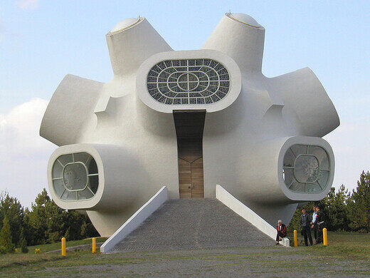
Ilinden Uprising Monument (Makedonium). This is one of the strangest looking monuments, a huge round white ball with 10 large round projections sticking out, 6 with clear glass and 4 with stained glass. Inside are several simple posters. It is also the Monument of the Partisans. 60 MKD
Mavrovo National Park. Formed in 1949, it is the largest park in North Macedonia in the far northwest of the country, part of the Bistra Mountains. It is home to the country’s highest peak, Mt Korab (2764m) and a ski resort near Mavrovo town.
From Krushevo, I entered Duf Waterfall in Google Maps and it gave the shortest route going west towards Ohrid. It was a great road (with a mammoth highway construction scheme occurring above it) until I was directed to a muddy stretch below some high towers of the new highway. This improved for a few kilometres into heaved pavement. I then hit a dirt road full of huge water holes that looked like a challenge for a good 4WD extending for 37 km up and over mountains into the park. I wisely turned around, reversed my course and headed for Tetovo. After 40kms, I turned onto the proper road into the national park and it was another 45kms each way to the waterfall past the Sveti Jovan Bigorski Monastery. I drove as far as the park and returned.
TETOVO
Tetovo Mosque South. A modern-looking mosque with a single minaret from the outside, I entered but the door to the mosque itself was unusually locked so I could not see the dome. The walls were plain white with faux marble columns.
Lešok Monastery (Arabati Baba Teke – Dervish Monastery). Inside a large stone-walled enclosure, the mosque has a lovely carved stucco dome and upper walls. The imam was giving a sermon to the several men present. There are several other separate buildings, part of the monastery. Nobody was doing any dervish dancing.
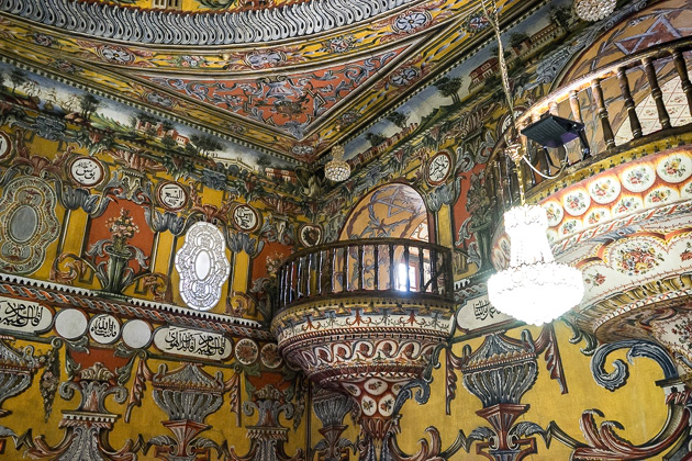
Painted Mosque (Šarena Džamija, Decorated Mosque). This is a spectacular mosque outside and in. The façade and portico are totally covered in leaves, Islamic designs and geometrics. Inside is equally spectacular with almost garish paintings covering the entire inside. Unusually, the dome had several small paintings of buildings amid all the acanthus leaves. I was given hell for entering in shorts. Free
Tetovo City Museum. The usual city museum with tired archaeology and local history. 60 MKD
