
Slovenia – Western March 18-. 2019
OBSERVATIONS ON SLOVENIA (a welcome change from Italy)
1. Everyone speaks good English.
2. The drivers are courteous, patient and have none of the bad habits of Italian drivers.
3. All gas in Slovenia is the same cheap price: €1.26.9. Amazing.
4. All houses are detached.
Kobarid is the first town encountered after crossing the Italian/Slovenian border. The Kobarid Museum shows the role soldiers from this town played in WWI. Mt Krn was strategic – they fought with the Austro-Hungarians against the Italians. There is also a section on the history of the town including Iron Age, Roman and WWII artifacts (many guns and uniforms). €4
My plan from here was to cross the extreme northwest of Slovenia through the Julian Alps next to the Austrian border and then see all the sights north of the capital city of Ljubjana. The drive was through several alpine villages surrounded by forested hills and craggy limestone peaks. Despite the rain and overcast, I still had reasonable views of some of the mountain vistas.
JULIAN ALPS are a mountain range of the Southern Limestone Alps that stretch from northeastern Italy to Slovenia, where they rise to 2,864 m at Mount Triglav, the highest peak in Slovenia and of the former Yugoslavia. They are named after Julius Caesar, who founded the municipium of Cividale del Friuli at the foot of the mountains. A large part of the Julian Alps is included in Triglav National Park. The second highest peak of the range, the 2,775 m high Jôf di Montasio, lies in Italy.
The Julian Alps cover an estimated 4,400 km2 (of which 1,542 km2 lies in Italy). They are located between the Sava Valley and Canale Valley and are divided into the Eastern and Western Julian Alps.
There are many peaks in the Eastern Julian Alps over 2,000 m high, and they are mainly parts of ridges. The most prominent peaks are visible by their height and size. There are high plains on the eastern border like Pokljuka, Mežakla and Jelovica.
The main peaks by height are the following:
Eastern Julian Alps: Triglav 2,864 m (9,396 ft) – the highest mountain and on the coat of arms of Slovenia, Škrlatica 2,740 m (8,990 ft), Mangart 2,679 m (8,789 ft), Jalovec 2,645 m (8,678 ft), Razor 2,601 m (8,533 ft), Kanjavec 2,568 m (8,425 ft), Prisojnik 2,546 m (8,353 ft), Rjavina 2,532 m (8,307 ft), Prestreljenik 2,499 m (8,199 ft), Špik 2,472 m (8,110 ft), Tosc 2,275 m (7,464 ft) and Krn 2,244 m (7,362 ft).
Western Julian Alps: The Western Julian Alps cover a much smaller area, and are located mainly in Italy. Only the Kanin group lies in part in Slovenia. The main peaks by height are Jôf di Montasio (2,755 m or 9,039 ft), Jof Fuart (2,666 m or 8,747 ft) and High Mount Kanin (2,582 m or 8,471 ft).
Important passes of the Julian Alps are:
Vršič Pass, 1,611 m (5,826 feet), links the Sava and Soča valleys. It is the highest mountain road pass in Slovenia.
Predil Pass (links Villach via Tarvisio and Bovec to Gorizia), paved road 1,156 m (3,792 feet)
Pontebba Pass (links Villach via Tarvisio and Pontebba to Udine), railway, paved road, 797 m (2,615 feet)
BOVEC. In northwestern Slovenia, close to the border with Italy, it is located 136 kilometres (85 mi) from the capital Ljubljana, at an elevation of 434 m (1,424 ft). The settlement lies in the Bovec Basin of the upper Soča (Isonzo) River, below the eastern slopes of Mount Kanin in the Julian Alps, forming the border with Italy. The adjacent Trenta Valley in the northwest leads into Triglav National Park.
History. In ancient times, the area was on the Roman road leading up to the Predil Pass. It was under the Hapsburgs after 1509, the Napoleonic Kingdom of Italy after 1754 and Austrian rule until 1918. Slovene completely replaced German as the language of everyday communication in the 19th century. During the last Austro-Hungarian period, two fortresses were erected along the Predil Pass road, the well-preserved Kluže in 1881–82 and the ruined Fort Hermann.
During WWI, the area was the theatre of the bloody Battles of the Isonzo, fought between Austro-Hungarian forces and the Italian Army between June 1915 and November 1917, which devastated the region almost completely. Over 600 soldiers are buried in the cemetery. Upon the 1918 Battle of Vittorio Veneto, Bovec was occupied by Italian forces and part of the Kingdom of Italy. Under the Italian Fascist regime between 1922 and 1943, the Slovene-speaking population of Bovec and the neighbouring villages was submitted to a policy of forced Italianization. Numerous locals, in turn, joined the underground militant anti-fascist TIGR organization, while many others emigrated to the neighbouring Kingdom of Yugoslavia.
During World War II, between 1943 and 1945, the area was occupied by Nazi German forces, and units of Slovene partisans were active in the area. After liberation, Bovec came under joint British-U.S. occupation. Bovec is the site of a mass grave with 11 German soldiers killed between 1941 and 1945. The grave was exhumed in 2000 and the remains were transferred to Žale Cemetery in Ljubljana.
In September 1947, the Paris Peace Treaties gave the town to Yugoslavia in 1951 and with the breakup of Yugoslavia in 1991, Bovec became part of independent Slovenia.
Economy. It largely depends on tourism. Another nondescript NM “small town, the area destinations include Boka Falls, Mount Triglav (2864 m), the Soča River, Lake Krn, the Kanin (Sella Nevea) ski resort, the Vršič Pass (1611 m), and the mountain road to the Mangart Saddle. Activities around Bovec include kayaking, rafting, hiking (the Peace Trail from Bovec to Kluže Fortress, the Soča Trail, and the Alpe-Adria Trail), performances by Društvo 1313, cheese tasting on the Mangart Plain, the Kanin circular cableway, Prestreljenik Window and other karst features, a zip line, and fishing.
Kluže Fortress. Sitting at the top of the pass on the way to Austria, this was a short 2.2 km north of the main road. A Roman fort and then a 15th-century Venetian fort preceded a 1505 fort built by the Austro-Hungarians when it held the regional government. In 1797, the French burned it down (the French destroyed everything they encountered after stealing anything valuable). In 1881-82, the Austrians built the present small, stone fortress with many narrow arrow/gun slits. Because of the advent of artillery, it was soon of little use and Fort Hermann with artillery was built above it in 1897-98. After WWII, it was abandoned, severely damaged in a 1982 earthquake and then rebuilt in 1987. The fort is now a museum open Sat/Sun in May and October and 7 days per week from June to September.
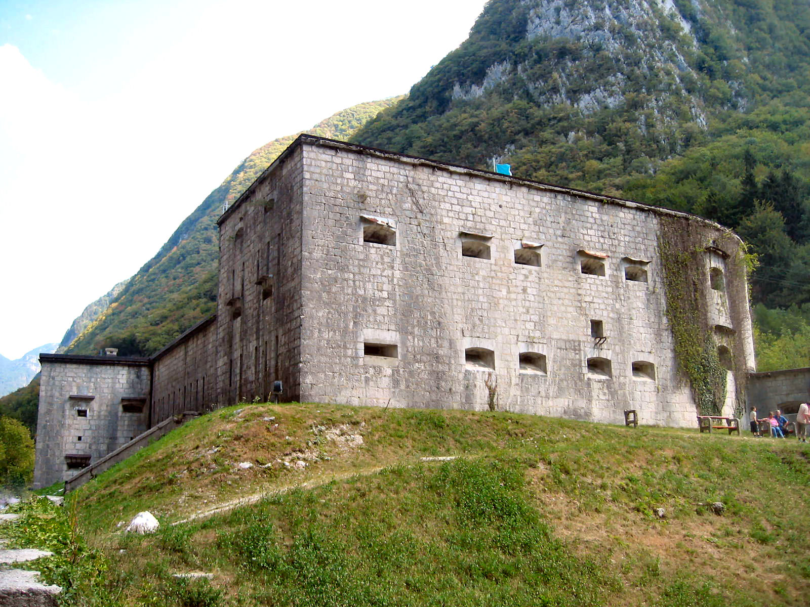
It sits right on the road and is small taking a few minutes to walk around. A spectacular deep, very narrow, limestone gorge forms the NE boundary – the bridge gives great views down into it. Across the road is the 1300m road/trail that ascends to Fort Hermann. It goes through a 113m tunnel that would require lights to navigate and looks like a great walk.
This trail forms part of the tentative WHS, The Walk of Peace from the Alps to the Adriatic – Heritage of the First World War (29/01/2016). The walk has all sorts of war memorabilia along it and continues to Bovec.
It started to snow lightly (2°C) and then in huge flakes as I drove through Trenta. Signs indicated I was in Triglav National Park. The road climbed and after turning onto the road to Juliana Alpine Botanical Garden, I was in 4 inches of soft snow that had not been plowed. I was surprised at how well the van with all-season tires and AWD handled the conditions. At the gardens (well under snow), signs indicated that the road continued to climb and snow would be a problem! I wisely turned around but briefly reconsidered when the snowplow came up the hill. Not knowing how far he was going, that was a good decision as he came up here only after seeing my tracks as he then followed me down.
So I had plan B and returned all the way to Kobarid to go south around the mountains. The road followed a lovely creek with bright green water that passed through a slot of limestone.
Tolmin. Another nondescript NM “small town” south of Kobarid.
I then made a decision to go straight east avoiding Ljubljana. The very narrow two-lane road was in a very narrow valley passing through many one-horse villages. With a thousand twists, turns and switchbacks, I was in 2nd gear as much as third. Then Google Maps got weird taking me on a narrow one-lane road with snow and I decided to ignore her for a while, got lost, repeated a 20km circuit and finally found the road going over a couple of snow-covered passes to Bled on the other side of the mountains. Temperatures reached a low of -2°C. Including an hour’s nap, it took me almost 4 hours to drive the 60 kilometres to Bled arriving well after dark. I parked right on the edge of Lake Bled on one of the darkest nights of the trip.
As I have said many times before, I have a love/hate relationship with Google Maps. Absolutely indispensable most of the time, it has 2 big problems: the algorithm likes short routes and you often find yourself in some back road (many speed bumps to almost 4WD) to save 10 metres. The other flaw is its instantaneous rerouting. If you miss a turn and are not looking at the screen, it reroutes so quickly, you may not realize it. She never says “make a U-turn”, and then with the difficult scale, I have driven 40kms over mountain passes (around Cinque Terre in north Italy) to return to exactly where I was an hour before!!! As I am now aware of this, I try to park and see what is happening. She sounds so confident, I often forget she is a computer and can be wrong, sometimes disastrously. She also does not do well when offline. My present maps don’t have a compass that I dearly miss.
I don’t think I will ever master how to use Google Maps most effectively.
Up early, I saw the following to wait till 10 am to see the museums in Bled.
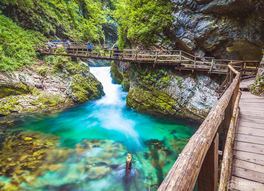
Vintgar Gorge. Discovered in 1891, the gorge was impassable. The 1.6 km long Vintgar gorge carves its way through the vertical rocks of the Hom and Boršt hills forming the Radovna waterfalls, pools and rapids. A trail goes over wooden bridges and Žumr’s galleries and ends with a bridge overlooking the 13 m high Šum waterfall.
The single-arch stone bridge of the Bohinj railway, constructed in 1906 crosses the gorge 33.5 m above the trail, and a dam routes water to the small Vintgar hydroelectric power plant under the Šum waterfall.
Don’t park at the first lot, but cross the bridge and drive downstream to a large lot and the ticket office. I walked down several hundred metres (the gate was unlocked because of the workers) and then was turned around by two workers – “it is not safety”. What I saw was still quite spectacular. It normally doesn’t open until mid-April. Cost?

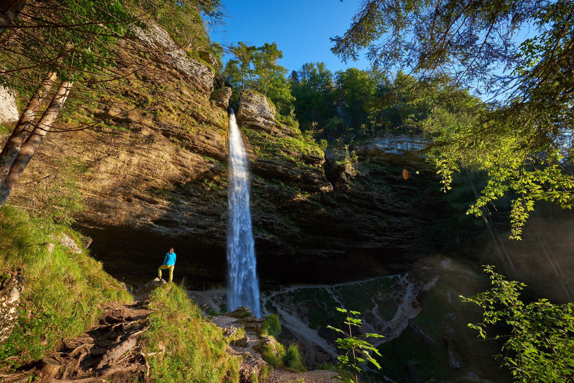
Peričnik Falls is one of the best-known waterfalls in Slovenia. It flows from a hanging valley in Triglav National Park into the glacial Vrata Valley, where the water of Peričnik Creek then flows into Bistrica Creek. There are actually two waterfalls: Upper Peričnik Falls (16 meters or 52 feet high) and Lower Peričnik Falls (52 meters or 171 feet high). A view of both falls is possible by crossing Bistrica Creek and ascending the scree slope a few dozen meters. The waterfall is particularly nice in the winter when the whole cliff face is covered in ice formations.
Drive through the village of Mojstrana, enter Triglav National Park, park at the signed lot and walk 5-7 minutes up the marked trail. It was not possible to walk behind the falls as as ice blocked the gully. There was about 5 cm of snow on the road and trail. Free
Slovenian Alpine Museum (Slovenski Planinski Muzej), Mojstrana. The museum has historical records with photographs of the history of mountaineering in Slovenia. It uses VR in an interactive game showing views of the top of mountains. Across from the museum are two Via Ferrata trails with equipment rented from the museum. €6
The easy Vrata valley trail ascends from the museum into the heart of the Julian Alps – passes the waterfall and gets views at the end of the valley of the 3km-high, 1km-wide North Face of Triglav (2864m).
The Alpine Association of Slovenia has 40 huts, all reserved at www.pzs.si. A great free is available at the museum shows details and their locations.
Upper Sava Museum (Gornjesavski Muzej), Jesenice. Stara Sava in Jesenice was the main centre of iron smelting in the valley. This museum has the remains of the old smelter (chimney, ruins of the original mill), a 1940s house for families of workers in the mill (30 families lived in the building where the ticket office is, four families shared one kitchen and each had their own “bedroom”), charcoal storage building has photos on the pillars and has a daily flea market (clothes and homemade cured meats), and several other sites in the mill. Free
An 8.8km long old mining route can be followed from Stara Sava to the mines in the area of the Sava Caves, an 800m elevation gain. The rich iron deposit was 1200m X 400m X 250m. The mines were closed in 1904 as the high-grade ore had been depleted. Many old mining memorabilia are along the trail.
BLED is a town on Lake Bled, most notable as a popular tourist destination. It is 50 km (31 mi) northwest of the state capital Ljubljana. A number of rises (Grad 599 m, Straža 646 m, Kozarca 558 m, Osojnica 756 m, and Ravnica 729 m) separate the localities of Bled around the lake, the former villages of Grad, Mlino, Rečica, Zagorice, and Želeče.
Bled lake is 2.12 kilometres long and 0.5 to 1 kilometre wide. In summer, the surface water reaches 25 °C (77 °F) and is suitable for swimming. In colder winters it freezes and is used for ice skating. There is a thermal spring (23 °C or 73 °F) near the lake, next to the Bled Fault. Its water is used in indoor pools in two hotels.
Today’s town began to form in the mid-19th century from the villages of Grad, Mlino, Rečica, Zagorice, and Želeče, which were encircling the lake. At that time, farmers started to sell the land along the eastern lakeshore to wealthy individuals for their villas, and the villages of Grad, Zagorice, and Želeče began to merge. Bled was officially recognized as a town in 1960.
Tourism. Bled is known for the glacial Lake Bled, which makes it a major tourist attraction. Perched on a rock overlooking the lake is the iconic Bled Castle. The town is also known in Slovenia for its vanilla and cream pastry. It became a health resort in the second half of the 19th century. Due to its mild climate, Bled has been visited by aristocratic guests from all across the world. Today it is an important convention centre and tourist resort, offering a wide range of sports activities (golf, fishing, and horseback riding). It is a starting point for mountain treks and hikes, especially within nearby Triglav National Park.
A small island in the middle of the lake is home to the Assumption of Mary Pilgrimage Church; visitors frequently ring its bell for good luck. One can get to the island on a traditional flat-bottomed wooden boat, a fixed fleet of 23 oared boats has been operating since the 18th century to protect the lake’s cleanliness. Each holds 18 passengers and goes hourly but may wait for a load. €15 return,
The island on Lake Bled has 99 steps. A local tradition at weddings is for the husband to carry his new bride up these steps, during which the bride must remain silent.

Bled hosted the World Rowing Championships for the fourth time in history in 2011. It previously hosted the championships in 1966, 1979, and 1989.
Dali Exhibition. On the lakeshore and under the Tourist Information in the same building as Casino Bled, it is not certain if it is ever open – there are no signs that it is here, but an office when you peer through the windows. I assume it is only open in the busy summer. Dali is my favourite artist and I was keen to see this. €6.50
Galerija Mikame. This tiny shop under the hotel behind the casino is not an ordinary tourist knick-knack store but has a great collection of hand-made items: wood sunglasses and bowties, a few watercolours, merino scarves with Slovenian designs and the highlight, his mother’s pottery. Free
Radivljica. Another NM ”small town”, has a small, pedestrianized “old town” with unusual faded frescoes on the facade of several buildings. The church was closed – strange for a Catholic church. The west side sits high above the valley below.
Basilica of Mary Help of Christians, Brežje. This small church has no aisles but side chapels, the most significant of Mary. It is a pilgrimage church with hundreds of framed art and embroidery with school pictures of families. Pope Jean-Paul visited in 1996. The facade has nice small mosaics. Free
Gorenjski Museum, Kranj. This history museum for the valley discusses farming and the iron industry among many other things. Past notable citizens include Janez Puhar many have been the first to take photographs on glass plates in 1840. €3
LJUBLJANA
Ljubljana is the capital and largest city of Slovenia. It has been the cultural, educational, economic, political, and administrative centre of independent Slovenia since 1991.
During antiquity, a Roman city called Emona stood in the area. Ljubljana itself was first mentioned in the first half of the 12th century. Situated at the middle of a trade route between the northern Adriatic Sea and the Danube region, it was the historical capital of Carniola, one of the Slovene-inhabited parts of the Habsburg Monarchy. It was under Habsburg rule from the Middle Ages until the dissolution of the Austro-Hungarian Empire in 1918. After World War II, Ljubljana became the capital of the Socialist Republic of Slovenia, part of the Socialist Federal Republic of Yugoslavia. It retained this status until Slovenia became independent in 1991 and Ljubljana became the capital of the newly formed state.
The city, with an area of 163.8 square km is situated in the Ljubljana Basin in Central Slovenia, between the Alps and the Karst. Ljubljana is located some 320kms S of Munich, 477kms E of Zürich, 250kms E of Venice, 350kms SE of Vienna, 224kms S of Salzburg and 400kms SW of Budapest. A number of earthquakes have devastated Ljubljana, including in 1511 and 1895.
Ljubljana has an elevation of 295m. The city centre is located along the Ljubljanica River. Ljubljana Castle, atop Castle Hill, south of the city centre, has an elevation of 366m. The highest point of the city, called Grmada, reaches 676 meters (2,218 ft), three m (9.8 ft) more than the nearby Mount Saint Mary peak, a popular hiking destination, both in the north part of the city.
Ljubljana’s climate is oceanic, with warm summers and moderately cold winters. July and August are the warmest months with daily highs generally between 25 and 30 °C, and January is the coldest month with temperatures mostly oscillating around 0 °C.
Ljubljana’s historic centre remains intact. Although the oldest architecture has been preserved from the Roman period, Ljubljana’s downtown got its outline in the Middle Ages but was rebuilt after each earthquake.
Ljubljana Card. This covers most museums, the tourist boat, a free bus, free wifi for 24 hours (outside only, this turned out to be pretty useless as the signal off and on and weak whenever I used it), has a free walking tour daily at 11 am, 4 hours of bicycle hire, and admission to a spa. €39 for 48 hours, €31 for 24 hours
Ljubljana Castle is a medieval castle on the summit of Castle Hill, which dominates the city centre. The area surrounding today’s castle has been continuously inhabited since 1200 BC. The castle was built in the 12th century and was a residence of the Margraves, later the Dukes of Carniola. The castle’s Viewing Tower dates to 1848; this was inhabited by a guard whose duty it was to fire cannons warning the city in case of fire or announcing important visitors or events, a function the castle still holds today. Cultural events and weddings also take place there. Since 2006, a funicular has linked the city centre to the castle atop the hill.
Ljubjana Central Market. Backing onto the canal, this is an open-air market with shops coming off a long portico. A market is also set up in the square in front.
Cathedral of St Nicholas. Unusually this smallish cathedral has no aisles or transepts. The ceilings are great frescoes and the chapels are marble creations. Gilt highlights several parts of the church. The highlights may be the wonderful bronze doors and its easily recognizable green dome and twin towers.
Preseren Monument. Sitting in a large square, this bronze statue of Preseren has a nymph with a branch over his head. Frances Preseren (1800-1849) was a Romantic, Slovene poet whose poems have been translated into at least 12 languages. He has been generally acknowledged as the greatest Slovene classical poet and has inspired virtually all later Slovene literature. Especially after World War II, one of Prešeren’s motifs, the “hostile fortune”, has been adopted by Slovenes as a national myth, and Prešeren has been described as being as ubiquitous as the air in Slovene culture.
Franciscan Church of the Annunciation (Cerkev Marijinega Oznanjenja). Located on Prešeren Square, it is the parish church of Ljubljana. Its red colour is symbolic of the Franciscan monastic order. Built between 1646-60 (the bell towers followed later), it replaced an older church on the same site. It has one nave and two rows of side chapels. Many of the original frescoes were ruined by the cracks in the ceiling caused by the Ljubljana earthquake in 1895. The new frescoes were painted in 1936
Monument to the Victims of All Wars. This is unusual with two large blank rectangular walls, two sets of three flags and running along the front of the step the saying: DOMOVINA JE ENA NAM VSEM DODELIENA IN ENO ZILJENJE, a piece from Oton Zipancic.
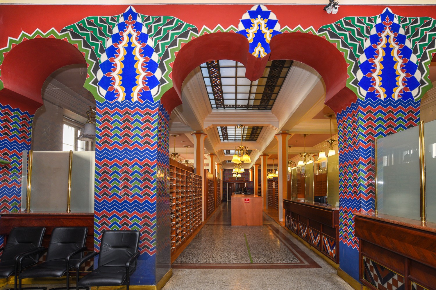
Vurnik House. The city’s land registry office, it is a fantastic building. The facade is an orange/red colour with red/blue/white geometrics splashed all over it. The inside is equally colourful with red and blue geometric patterned walls.
Nebotičnik (“Skyscraper”) is a thirteen-story, 70.35 m high building. Nebotičnik has a variety of shops on the ground floor and first story, and various offices are located on floors two to five. The sixth to ninth floors are private residences. Located on the top three floors are a café, bar and observation deck. It opened on 21 February 1933 and for some time was the tallest residential building in Europe. The only “feature” is a small statue halfway up the SW corner.

National Gallery of Slovenia. Showcases Slovenian art, mostly up to 1850 or so. Much is religious and of variable quality.
Museum of Modern Art. Mostly Slovenian art, some is interesting.
Slovenian Museum of Natural History. Rocks, shells, butterflies, stuffed birds and mammals, snakes in bottles.
Slovenian National Museum – Presernova. In the same building as the Natural History Museum, it has some pretty boring archaeology.
Ljubljana Historical Centre and Castle. Take the funicular from near the church and Central Market up the mountain to see the castle. The funicular was built in 2006 and is only a 2-minute ride. The first castle was built in 1144 and two more until the last in 1544. Great views of the city.
National and University Library. The main attraction here is the Reading Room that is only open to visitors from 2:30-6 on Saturdays and costs €5. However, the stairs and rotunda area have amazing dark grey marble and are very pretty.
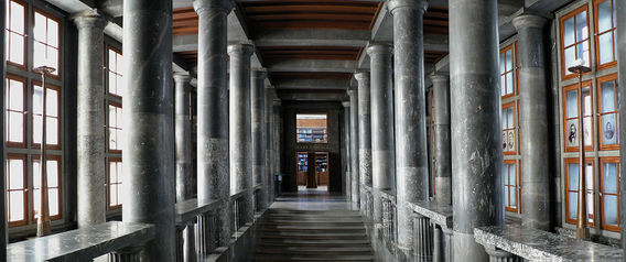
There is a small exhibit with some books and you can even go to the cafe for free!! I asked to see some pictures of the reading room and all they had were some small postcards. For the best photos, go to the Plecnikova House. A German plane crashed into the reading room during WWII and destroyed it.

The outside is also quite interesting with red brick and natural stone.
City Museum of Ljubljana. (Mestni Muzej Ljubljana). This is an unusually well-done museum for a municipal museum, mostly because the labels are terse and to the point. The 5000-year-old wooden wheel may be the oldest wheel in the world. The temporary exhibit was on Ivan Cankar (1876-1918), an Austrian journalist and writer who lived for several years in Ljubljana. He had many interesting insights into Slovenian society, most very critical.
Plecnik House (Plecnikova hise). Jose Plecnik (1872-1957) was a noted Slovenian architect. His buildings are in Vienna, Prague and Ljubljana, all places where he lived. A guided tour of his actual residence occurs on the hour and was very interesting as the guide was so animated. I’m sure Plecnik had Aspergers Syndrome as he was very antisocial, wasn’t interested in women, and had some really quirky ideas. His chairs were made to be uncomfortable as that way you had to sit straight and be alert. Everything was ultra-functional. The house with its round main rooms, guest room (where no guests were allowed to stay), entrance area and sunroom were all lovely and factual as to their content (even down to the 2cm pencil remnants). The garden is large and very functional.


KUD France Prešeren. This is a very nice performance venue hosting a wide variety of entertainment from jazz and concerts to standup comedians. The rooms consist of a large coffee shop, small auditorium and music lesson rooms. They hold a free month-long music festival in August.
I then had a real walkabout getting to the next sight as canals kept getting in the way.
University Botanical Garden. Originating in 1810, the University has owned it since 1919. There is a tropical greenhouse (admission €2.80) and large gardens that are free. There was nothing blooming at this time of year.
I then walked around the back of the mountain the castle is on, returned to my car and drove to the next sites.
Museum of Architecture and Design. The temporary exhibit was on water – mainly the marshes that form the south boundary of Ljubljana. Originally settled by people who lived in pile dwellings 5000 years ago, they are now urban and prone to the occasional flood. Ideas to make them eco-friendly are in the plans. The only architecture and design was a tiny room with a “gondola chair”, kind of weird. It took me triple the amount of time to drive here and back as to see the exhibits.
These next three museums sit next to each other in north Ljubljana.
National Museum of Slovenia – Metelkova. There were a lot of interesting things here: glass and porcelain, chairs, furniture, toys, weapons and armour, bells, silver and much more.
Slovenia Ethnographic Museum. The temporary exhibit was on bees and bee-keeping. There were many ancient hives and interesting art decorating the ends of many of the individual boxes. The museum of Bosnia-Hers lent a wonderful photography exhibit with silver-gelatin prints from the early 1900s – the photographers actually had a good eye. Also interesting kitchen utensils.
Mensa pri koritu (MSEM – Museum of Contemporary Art). There was an interesting exhibit on War Monuments, Slovenia’s cultural exchanges over decades, some typically lousy photography and a display on the Non-Aligned Movement.
Railway Museum (Zebzonicki Muzej). In a huge roundhouse, it had the usual locomotives and some uninteresting passenger cars. A toy train circulates on a tiny track.
Vurniflova Ulica. This large bar/restaurant has an active social scene.
Museum of Contemporary History. In the lovely, pink and white Cekinova Grad, the permanent exhibition here is the history of Slovenia from the end of WWI in 1918 to the present – a turbulent time in Slovenia’s history with multiple changes of government. After WWII, socialization and industrialization in communist Yugoslavia to independence in 1991 and the joining of the European Union. The temporary exhibition is a nice photographic display – Looking through the window.
Kino Siska. A performance venue, this has a lounge and two concert halls showcasing music of all genres from around the world. There are acts almost every night, but no dancing. Price varies according to the act.
Bokalce Castle. About 5kms west of Ljubljana, this is an odd NM site, an old decrepit manor house that looks like it has been closed for decades. It is surrounded by equally decrepit farmhouses.
I then went to NW of Ljubljana to see the following before returning to Italy and Trieste.
IDRIJA
Idrija is a World Heritage Site – Heritage of Mercury combined with Almaden Spain. It is the oldest mining town in Slovenia above the second-largest mercury ore deposit in the world (after Almaden in Spain). Mercury was first discovered here in 1490 – it is relatively rare, liquid at room temperature, 13x heavier than water and 2x heavier than iron. Long known as a polluter and health hazard, it has been replaced and most of the mines in the world have been closed, including these two. It was primarily used to amalgamate gold and silver from the 16th century in Central and South America. There are many sites in Idrija that show the mining heritage:
Read all about Mercury.
Gewerkenegg Castle. The old mining office has the Idrija Municipal Museum. Besides the mining history and the history of the town, there is a large exhibit on lace making.
Anthony’s Main Road. This preserved mine entrance dating from the 16th century offers one-hour guided tours of the mine. It contains the Chapel of the Holy Trinity, now a museum. I took the guided tour €13, €10 reduced.
On the excellent tour, I learned much more. Originally miners started their career at age 15-16 but were dead by age 35 because of silicosis of the lungs and/or mercury poisoning. More recently the life expectancy was 60 because of improved conditions. Over the 500 years of operation, there were only 300 deaths due to mine accidents, a relatively low number. Mining techniques were exhibited at several stops: from originally working in the dark using a hammer and chisel to air-powered drills and finally to mechanical excavators. Of the original 700 km of tunnels, there are only about 5kms left. They have all been filled with water or rock. Backfilling tunnels and excavated areas was very important as the town was sinking from all the rock removed.
Mercury occurs either as specific droplets of pure metal (easily visible) or as cinnabar, a combination of sulphur and mercury – the higher the concentration, the red the rock.
In the smelter, the rock was crushed and then heated to 800°C and the mercury “boiled” off and collected as a distillate.
150,000 tons of mercury were produced over the lifetime of the mines here, with an average of about 240 tons/year. The maximum in one year was 830 tons and production was always greatest during wartime as mercury was used to make bullets. As the need for mercury became almost nil, the mines here started to close in 1977 and all were shut down by 1987. There was thought to be at least another 40 years of production left.
Smelting plant. Presents the mercury extraction process.
Miner’s Street. 1870 miner’s housing.
Rake. A 2.6 water channel from the Idrija River to the mine.
Kanst. 1790 water-driven pump to drain pit water with a 13.6m wooden drive wheel.
Joseph’s Shaft. 1736 shaft connecting 15 mine levels to a depth of 382m.
Francis Shaft. 1782 entrance shaft.
Gorizia/Nova Gorica. In the NM “XL” series, this is in the extreme east of Italy/extreme west of Slovenia.
I then returned to Italy to see my second WHS for the day at Aquiliea.
After sleeping along the water north of Triest, my goal for the day was to finish the rest of Western Slovenia and primarily to see my third World Heritage Site in two days (Škocjan Cave in Divača). I crossed the Italian border into Slovenia and on the way to the cave stopped at:
Sezana Botanical Park, Sezana. March is not the best time to see botanical parks if seeing flowers is your goal. This pretty park has some nice trees and hedges but was not worth the drive to get here. Free
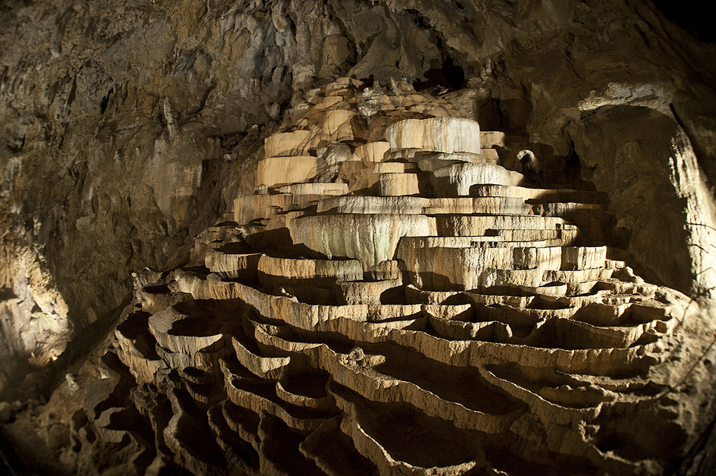
Skocjan Cave, Divaca. I have been to many of the world’s great caves and of them all, this has the worst dripstone formations. But it is a World Heritage Site because of the wonderful canyon and Reka River that flows through it. The river flows for 50 km above ground and then sinks into the karst underground before resurfacing again at Timavo Springs near the Gulf of Trieste.
The cave is 7.5 km long and can only be seen on a guided tour. I took the Classic Tour at 10 am that visits 2.5 km of the cave. The walkways are all constructed concrete sidewalks. The cave was World Heritage listed in 1986 both for the river and the cultural remnants constructed by the first explorers from when the cave was first discovered in 1851 and into the early 1900s. Over 10kms of stairs, walkways and bridges were constructed and most are still intact.
Walk down a long gravel path to the 100m tunnel/artificial entrance to the cave. The first half of the tour goes through the Silent Cave. It has some mediocre dripstone formations. The roof of this cave collapsed and destroyed or covered up the dripstone that had formed. High above the river, this section was discovered relatively late. The highlight is the 100m x 30m high Big Chamber with some dripstone curtains, terraces of travertine basins and crooked stalactites caused by the air currents in the cave. Bats left this area of the cave after it started to be explored.
Then you start to hear the roar of the river far below and descend to the high point of the Murmuring Cave. A plaque indicates the water level of the 1964 record flood when the water level was 100m above the river. In February of this year after 2 days of rain and warm weather melted a lot of snow, the cave flooded to 75m above the river. The cave was closed for 2 weeks to clean up all the debris.
The canyon part is really quite spectacular with a big roar, rapids and waterfalls. The old trails and stairs go everywhere. Take a short funicular at the end. €18, €14 reduced

After the cave, I crossed back into Italy to see two last things and to get some cheap AdBlue (this is a pollution control fluid with its own filler tank; if empty, the van will not start; I get about 7000kms per 9litres). I had paid €16 for 4 litres at a gas station in Slovenia and paid €10.90 for 8.9 litres in Italy. It comes in 8-litre plastic jugs and occasionally can be filled at a pump at some gas stations.
A narrow tongue of Western Slovenia cuts between Trieste and northern Croatia giving Slovenia access to the Adriatic Sea and the Mediterranean. The Istra coastline of Slovenia is 47 km long.
KOPER
Koper Cathedral. Koper is a medieval town with narrow lanes. Google Maps always takes you completely to your destination. Here the lanes were so narrow, I had to rotate my rearview mirrors to just squeeze through. Once you get into these positions, the only reasonable course is to continue driving forward as trying to back up without mirrors would be challenging.
The cathedral sits on the main square of old Koper. An original church was built here in the 5th century and this was the fifth building to stand on the site. The church itself is only average inside with the usual embellishments. The Ways of the Cross were lovely modern paintings. The highlights of the cathedral are the 160’ high bell tower and the 13th-century round baptistry (The Chapel Church of Our Lady of Mt Carmel which unfortunately was closed – it looks like it is rarely available to be seen).
PIRAN
This is a pretty seaside resort town with medieval lanes. You even have to pass a parking barricade to get into the town. It clearly tries to eliminate cars from its narrow roads. In the centre is a large oval piazza surrounded by the town hall and many restaurants.
Punta Caffe. On the very tip of the peninsula where Piran sits, and away from the main restaurant row is this small coffee/drinks and ice cream store. It has a bunch of tables on the sidewalk and across the narrow street next to the rocks. There is nothing special about this place other than its location and view across the bay to Trieste and the Julian Alps in the distance.
St. George’s Church. Sitting on the edge of the water on the east side of the peninsula of Piran, its tall stone bell tower is the town landmark. The church is average with a plain white exterior and interior and the usual marble side altars, pillars and religious art. But there is a great statue of St George killing the dragon on the east wall. Sitting next to the bell tower is a nice hexagonal Baptistry.

Muzej Skoljk (Seashells Museum; the NM listing is the euphemistic Magical World of Seashells). Impossible to find with Google Maps and without asking the locals, it sits on the west side of the oval piazza up some stairs. There are some 4000 shells here, the most interesting are all the fossil shells. €4
Maritime Musuem (Pomorski Muzej del Mar). In a nice mansion sitting across the street from a small inle, it has a good history of the maritime role of Piran with the usual ship models, paintings of ships and people and maps. €5, €4 reduced
I then filled up with cheap Slovenian gas and crossed into Croatia, my first border control and passport stamp in 7 countries and over two months
