
Farfa Abbey (Abbazia Benedectine di Farfa) 4kms NW of the town of Castelnuovo di Farfa, Google Maps had its greatest failing yet in navigating to this monastery. I descended a very narrow single lane road and should have presaged what was next when it crossed a stream with no bridge. The “road” soon degenerated into a 4X4 rutted track that my van did not have the clearance to deal with, forcing me to back down several hundred yards. Despite finding the correct road, GM recurrently redirected me back. I was disappointed to see the sign on the ticket office that offered guided tours hourly beginning at 10am, but wandered around to the side and found the door to the church open. The inside is covered with frescoes including several popes and many saints. The choir at the back of the church has a lovely wood music stand holding one of the huge hymn books. Free

Cascata delle Marmore (Marmore Falls) is a man-made waterfall created by the ancient Romans. Its total height is 165 m (541 feet), making it the tallest man-made waterfall in the world. Of its 3 sections, the top one is the tallest, at 83 m (272 feet). It is located 7.7 km from Terni.
Its source is a portion of the waters of the river Velino (the rest of the river flows into a hydroelectric power plant), after flowing through Piediluco lake near the community of Marmore. It pours into the valley below formed by the river Nera. Its flow is turned on and off according to a published schedule, to satisfy the needs of tourists and the power company alike. Tourists try to be there the moment the gates are opened to see the powerful rush of water.
History. The Velino river flows through the highlands that surround the city of Rieti. In ancient times, it fed a wetland in the Rieti Valley that was thought to bring illness (probably malaria). To remove that threat to the city of Rieti, in 271 BC, the Roman consul Manius Curius Dentatus ordered the construction of a canal (the Curiano Trench) to divert the stagnant waters into the natural cliff at Marmore. From there, the water fell into the Nera river below. However, that solution created a different problem: when the Velino river was in flood stage, its water flowed through the Nera toward the city of Terni, threatening its population. The issue was so contentious between the two cities that the Roman Senate was forced to address it in 54 BC. Aulus Pompeius represented Terni, and Cicero represented Rieti. The Senate did nothing about the problem, and the problem remained the same for centuries.
Lack of maintenance in the canal resulted in a decrease in the flow until eventually, the wetland began to reappear. In 1422, Pope Gregory XII ordered the construction of a new canal to restore the original flow (the Gregorian Trench or Rieti Trench).
In 1545, Pope Paul III ordered that a new canal be built (the Pauline Trench). The plan was to expand the Curian Trench and to build a regulating valve to control the flow. Upon its completion some 50 years later (in 1598), Pope Clement VIII inaugurated the new work, and named it after himself: the Clementine Trench.
In the following two centuries, the presence of the canal was problematic for the countryside in the valley below, as the Nera often flooded it. In 1787, Pope Pius VI ordered architect Andrea Vici to modify the leaps below the falls, giving the falls its present look and finally resolving the majority of the problems.
In 1896, the newly formed steel mills in Terni began using the water flow in the Curiano Trench to power their operation. In the following years, engineers began using the water flow to generate electricity.
Most of the time, the water in the canals above the falls is diverted to a hydroelectric power plant, so the flow in the falls themselves is heavily reduced. Piediluco Lake, above the falls, is used as a reservoir for the power plant. The Galleto power plant, built in 1929, is architecturally interesting. Its capacity is about 530 MW. To control the operation of the power plant, and to satisfy tourists, the falls are turned on according to a set schedule, achieving a spectacular effect at full flow. An alarm is sounded first, then the gates are opened, and in a few minutes, the small stream is transformed into a full-sized river rushing into the void below. Normally, the falls are turned on between 12:00 and 13:00 and again between 16:00 and 17:00 every day, with additional times on holidays. An entrance fee is charged to visit the falls and the surrounding area.
A path along the falls allows the visitor to hike up to the top of the falls. Along the way, a tunnel leads to an observatory just next to the falls, where a visitor is guaranteed to get soaked. A safer observatory near the top affords a grandiose view of the falls and of the Nera valley below.
It is a walk down from the ticket office (closed at this time of year), cross a bridge over the canal, and pass several tunnel openings and small canals. Descend to the upper viewpoint for great views of the falls. There are three lower viewpoints reached on stairs. This and Valnerina: Monastic sites and ancient hydrogeological reclamation works (01/06/2006) are a Tentative WHS.

Civita di Bagnoregio.
History: Civita di Bagnoregio was founded by Etruscans more than 2,500 years ago. The Civita (or City) was the birthplace of Saint Bonaventure, who died in 1274. The location of his boyhood house has long since fallen off the edge of the cliff. By the 16th century, Civita di Bagnoregio was beginning to decline, becoming eclipsed by its former suburb Bagnoregio.
At the end of the 17th century, the bishop and the municipal government were forced to move to Bagnoregio because of a major earthquake that accelerated the old town’s decline. At that time, the area was part of the Papal States. In the 19th century, Civita di Bagnoregio’s location was turning into an island and the pace of the erosion quickened as the layer of clay below the stone was reached in the area where today’s bridge is situated. Bagnoregio continues as a small but prosperous town, while the older site became known in Italian as La città che muore (“The Dying Town”). Civita di Bagnoregio has only recently been experiencing a tourist revival.
The town is noted for its striking position on top of a plateau of friable volcanic tuff overlooking the Tiber river valley. It is in constant danger of destruction as the edges of the plateau collapse due to erosion, leaving the buildings to crumble as their underlying support falls away. As of 2004, there were plans to reinforce the plateau with steel rods to prevent further geological damage.
The city is also much admired for its architecture spanning several hundred years. Civita di Bagnoregio owes much of its unaltered condition to its relative isolation; the town was able to withstand most intrusions of modernity as well as the destruction brought by two world wars. The population today varies from about 7 people in winter to more than 100 in summer.
Google Maps took me to a rural valley far below this medieval village sitting atop a volcanic plug – fortunate as this is the best place to appreciate the spectacular setting. Drive through the town of Bagnoregio to the parking areas at the east end of the town. Stairs lead down from the viewpoint to a road, the ticket booth and the bridge that descends and then ascends into the village. An arched stone bridge was built in 1923 but was destroyed by landslides and the retreating German army in 1944. The present reinforced concrete bridge was opened in 1963.
Unless you want to eat at the many restaurants or buy souvenirs, I would suggest not wasting €5 to enter the town. Beside old stone houses, the 1699 church has little to see (contains the silver reliquary containing the bones of St Banaventura). There are few views of the valley below. The Cultural Landscape of Civita di Bagnoregio is a Tentative WHS.
ORVIETO (pop 21,000)
Orvieto sits on top of a volcanic plug, making it an imposing sight from the valleys surrounding it. The upper town is full of cobbled lanes, medieval plazas and churches and is a Tentative WHS (01/06/2006). A public park on the south side has wonderful panoramic views down to the valley far below.
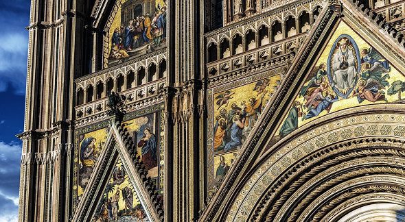
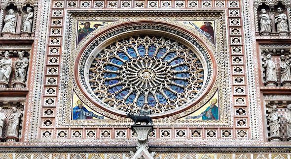
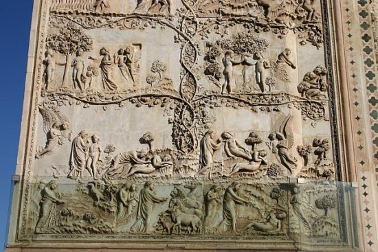
Duomo. Few churches can compare to the spectacular façade of this Gothic cathedral dating from 1290, taking 30 years to plan and 300 to build. The interior and exteriors are green and white banded serpentine and limestone. The façade is a display of bas-reliefs, mosaics, spiral columns and geometric mosaic inlays.


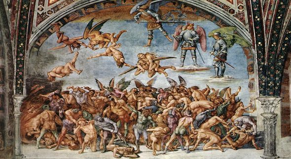
The main body of the church is plain with some faded frescoes in the small dome side “chapels, but the chapels in the transepts are exceptional. The vast fresco covering every inch of the west Cappella di San Brizio is a grotesque depiction of the Last Judgement. On the other side of the transept is the Cappella dei Corporale housing a 13th century 48X50 centimetre altar cloth stained with blood miraculously poured from the communion bread of a priest (on display 4 times a year). Other highlights are the great bronze doors and wood inlaid altar between the choir stalls. €5
Orvieto Funicular. This typical funicular goes from the train station at the bottom to near the bus station in the upper town. €1.30 each way
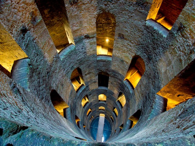
Well of the Cave (St Patrick’s Well). Combining engineering and architectural décor, this was commissioned by Pope Clement VII in 1527 following his stay in Orvieto. Rome, sacked by the imperial army in the same year, was becoming unsafe. Orvieto was considered a place of Papal refuge making it likely to be besieged so there was a need for a reliable water supply. A well was designed to tap the springs of Mt Zeno that emerged from the foot of the cliff. The well was completed in 1537 and was given its strange name as it supposedly resembled St Patrick’s Cavern in Ireland. The well is a vast cylinder 53.13m deep and 13m wide initially cut out of rock but lined with bricks lower down. Two independent spiral staircases, each with 248 steps, one for descending and one for ascending, were built large enough to accommodate the donkeys used to carry water to the surface. 70 windows cut into the wall light the stairs, but it is still gloomy and dark. It is a long climb both ways. An inscription on the wall states “QUOD NATURA MUNIMENTO INVIDERAT INDUSTRIA ADIECIT” (what nature stinted for provision, the application has supplied). €5, no reduction
Orvieto Underground. This series of 440 caves has been used for millennia including as a WWII bomb shelter has 45-minute tours. €6
ASSISI (pop 27,400)
The modern lower town buts against Monte Subasio and the upper town, mostly pedestrianized. The entire upper town is light cream in colour, visible for miles around. The church has an active monastery with the monks giving tours and manning the ticket booths.
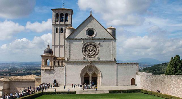
Basilica di San Francesco. Sitting on the north tip of the upper town, this white limestone church is the highlight of Assisi. St Francis (1181-1226) was born in Assisi. The son of a wealthy cloth merchant, he was quite worldly. Initially in the army, he had a holy vision in 1205, renounced his inheritance and began a humble, ‘primitive’ life in imitation of Christ. He traveled widely around Italy and to Egypt (in 1219 he preached the Gospel in front of the Sultan), performing miracles such as curing the sick, communicating with animals and founding monasteries. He spent months praying in a cave as a hermit. Before long, his wise words and good deeds had attracted a crowd of followers. He had asked his followers to bury him in Assisi on a hill known as Colle d’Inferno where people were executed at the gallows until the 13th century, so as to be in keeping with Jesus, who had died on the cross among criminals and outcasts.
He was canonized just two years later, after which the business of ‘selling’ St Francis began in earnest, making modern Assisi an ironic comment on Francis’ ascetic and spiritual values with all its tourist-derived business.
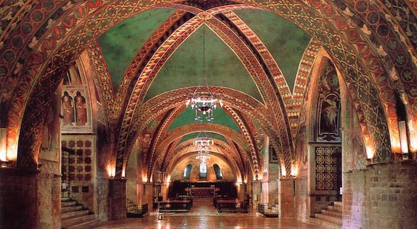
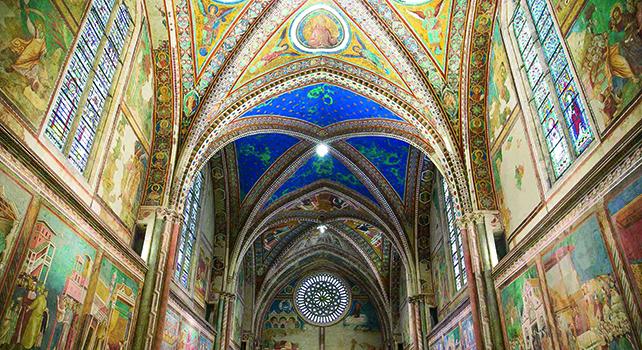
The Romanesque lower church (Basilica Inferiore) was started two years after his death and has a much lower ceiling (blue with yellow stars and geometrics painted on the ribs of the vaulted ceiling). The walls are covered with several frescoes, the forerunner of Roman church painting to follow. The crypt contains his elaborate and monumental tomb (crowded with people praying) – his body was transferred here in 1230, but the sarcophagus was not on view until 1888 when the crypt was built.
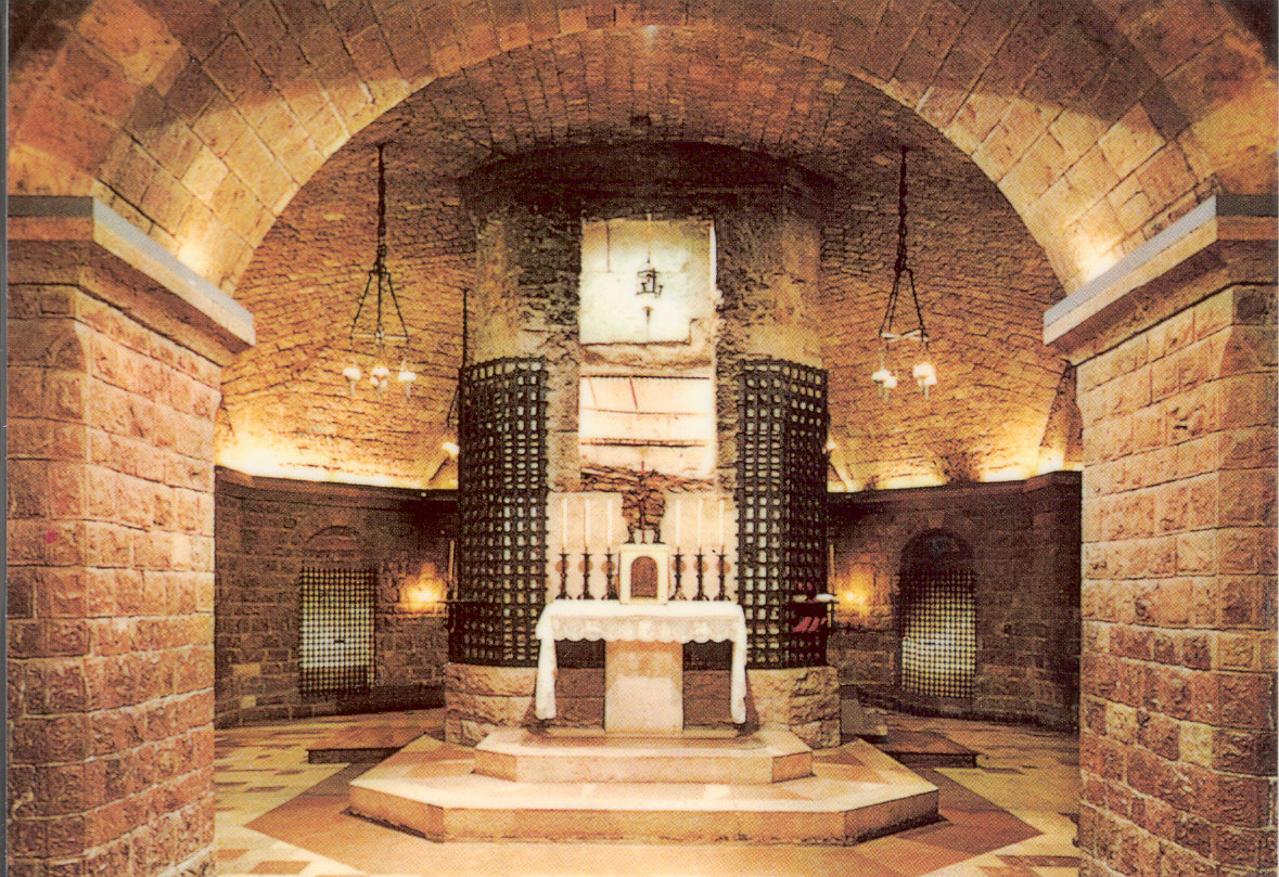
Tomb of St Francis in the crypt
The upper church (Basilica Superiore) was built immediately after the lower church between 1230 and 1253. With no aisles, it is home to one of Italy’s most famous works of art – a series of 28 frescoes depicting the life of St Francis (the one with the halo around his head). From 1250-1330, both churches were painted by some of the greatest artists at the time. They are still vibrant and colourful.
Assisi, the Basilica of San Francesco and Other Franciscan Sites is a World Heritage Site. Other places that claim links to St Francis are Gubbio (where he brokered a deal between the townsfolk and a man-eating wolf – Francis tamed the wolf with the promise that it would be fed daily), Rome (Francis was given permission by Pope Innocent III to found the Franciscan order at the Basilica di San Giovanni in Laterno), Greccio in Lazio (created the first live nativity scene in 1223), Bevagna in Umbria (preached to the birds) and La Verna in Tuscany (received the stigmata shortly before his death at the age of 44).
PERUGIA
Perugia is the capital city of both the region of Umbria in central Italy, crossed by the river Tiber. The city is located about 164 kilometres (102 miles) north of Rome and 148 km (92 miles) southeast of Florence. It covers a high hilltop and part of the valleys around the area. The region of Umbria is bordered by Tuscany, Lazio, and Marche.
Perugia was one of the main Etruscan cities. The city is also known as the universities town, with the University of Perugia founded in 1308 (about 34,000 students), the University for Foreigners (5,000 students), and some smaller colleges. Perugia is also a well-known cultural and artistic centre of Italy. The city hosts multiple annual festivals and events, e.g., the Eurochocolate Festival (October), the Umbria Jazz Festival (July), and the International Journalism Festival (in April), and is associated with multiple notable people in the arts. The city’s symbol is the griffin, which can be seen in the form of plaques and statues on buildings around the city.
Galleria Nazionale dell’Umbria. In the centre of the city, this art museum is in the Palazzo Priori building. Starting on the 3rd floor, it has only religious art, specializing in Umbrian artists. I hate this stuff. Artists were a dime a dozen, believed all the crap perpetrated by the Catholic church and produced enormous volumes of art, that basically repeat the same theme. They had a huge role in perpetuating all the myths: virgin birth, son of god, rising from the dead, on and on. €8 no reduction
Palazzo Sorbello. This “house museum” was the residence of the Marqueses Bourbon di Sorbello, a noble family of Perugia. It was purchased in 1780 and shows the house as of the 18th century with elaborate frescoes, paintings, chandeliers, Ginori porcelain, embroidery, and a historic library. The main foyer has views overlooking Perugia and Assisi.
It is accessed up a narrow passage and street. €8 no reduction.
