
Greece – Epirus – March 31-April 1 2019. This part of Greece stretches across the entire north of the country. I entered the Epirus region from Albania at noon on March 31, with 2 weeks remaining on my Schengen visa. The border crossing is at least 50 km from the Aegean coast. After a thorough search from the Albanian police (they specifically asked if I had any marijuana or cocaine and I wondered why they would even bother as I was leaving), the Greeks were much more pleasant. The roads were a big improvement over the ones in Albania, but the terrain is also much gentler. Most road signs are only in Greek. I’m sure that is the origin of the saying “looks like Greek to me” – it is completely indecipherable. The menus in most of the restaurants were only in Greek.
ZAGOROHORIA From an old Slavic term, za Gora (behind the mountain) and horia, the Greek word for villages, this region is centred on the Pindos Mountains in NW Greece. 46 remote, preserved mountain hamlets full of tiny stone and slate houses to fortified mansions were once connected by paths and old stone bridges. Zagorochoria – North Pindos National Park are a tentative WHS (16/01/2014). The centrepiece is Vikos-Aoös National Park, an area of pristine rivers and forests, meadows, lakes and jagged mountains. Vikos Gorge. Europe’s deepest gorge, it is 900m (2950’) deep and 1100m between its rims. Park at the signed lot and walk through the tiny tourist village of Monodendri. A 600m-long cobbled road descends to a viewpoint.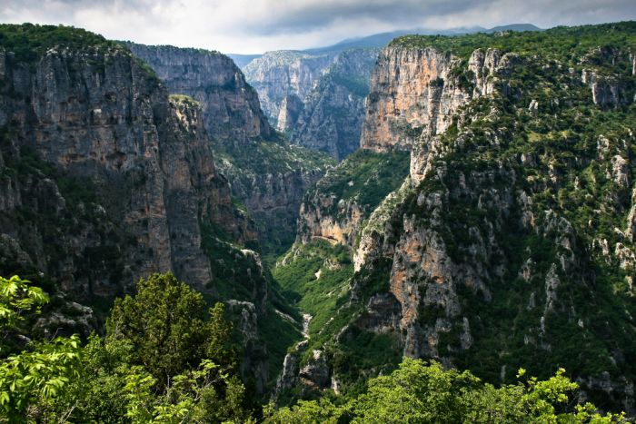
For a better view enter the monastery of Moni Agia Paraskevi with its fading frescoes on the church walls and walk through to get a good view into the north branch of the canyon (the most spectacular) and then south to where the canyon is its deepest. I was rather disappointed – the area consists of 3 branches at the headwaters of the canyon. The canyon is only a few hundred metres long. Compared to other great canyons (Grand Canyon or Colca Canyon of Peru), this pales. I was completely alone when I arrived but passed a group of 53 students on the way back. Supposedly a steep marked path descends from here but I saw no evidence of it. A narrow trail hugs the SW wall, but it appears very precarious. It is a 4-hour walk to the end of the canyon. The Klima Spring, halfway along the gorge is the only water source. Dilofo. The highlight of the tiny villages, park in the lot and walk down the rough cobble lanes to a small square with a massive tree and then up to the church with its bell tower (closed). I was the only person in town when I visited – it was very quiet. There is a restaurant at the entrance.
Dikofo. A winding road leads 10 km to this very small village clinging to a hillside. A 2-story church with a blue-roofed bell tower is the highlight. Most of the houses were shuttered. A completely out-of-place modern 4-story reinforced concrete shell sits in the middle of it all. It appears that construction halted some time ago. There is a great view of the snow-covered Pindus Mountains to the north.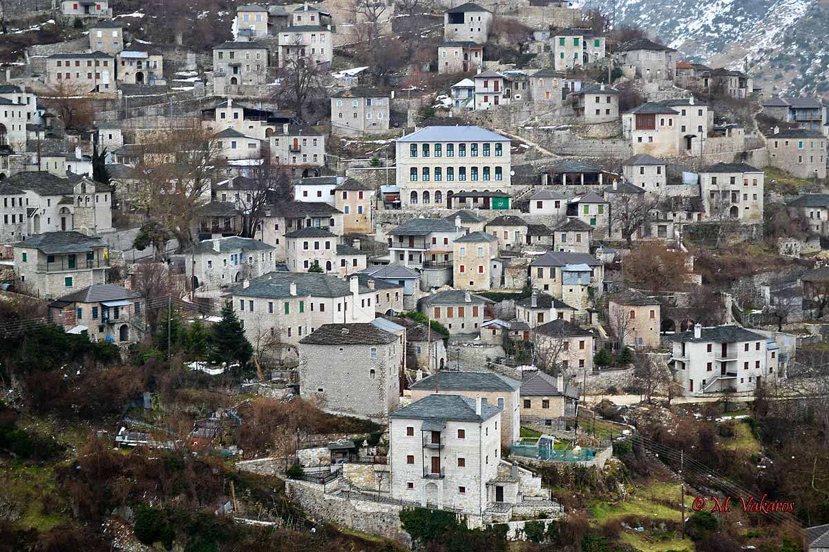
IOANNINA (pop 70,000) With a significant history of Byzantine and Ottoman rule, this modern university town and commercial center has 20,000 students. It sits on the north end of Lake Pamvotis. It is hard to know where the Old Town starts (in the castle?) Ioannina Castle. This huge fort with imposing high walls occupies the entire bluff on the SE end of the city. Gates are on the north and south and the east end has no wall remaining. Expecting cute stone houses and medieval lanes, this is a residential neighbourhood with modern-looking stucco homes. Towards the north, the area looks older. Outside of the walls in the north are many bars and restaurants packed with university students drinking coffee and beer. Byzantine Museum. The treasures here include early printed Greek books from Venice and ornate silver jewelry boxes with cloisonné enamel. Textual accompaniments give an overview of Ioannina’s history from the 4th to the 17th century. The Byzantines conquered Ioannina in 1082. Feliyie Mosque. Built in 1430 at the start of Ottoman rule on the site of a Christian church, it was restored by Ali Pasha. 2 marble columns from the church are on either side of the mihrab. Municipal Ethnographic Museum. In the Feliyie Mosque, local costumes, period photographs, tapestries and prayer shawls from the synagogue of Ioannina’s once-significant Jewish community are exhibited. After liberation from the Ottomans in 1913, it was used as a military hospital. A plaque on the Byzantine Museum marks the location when in March 1944, the Germans rounded up the Jews of the town for transport to concentration camps. Tomb of Ali Pasha. Outside next to the mosque, his decapitated body was buried here in 1822 next to his wife. A lovely domed iron railing covers the grave. Archaeological Museum of Epirus. With artifacts from all over the area, like all archaeological museums, this one starts with the Neolithic period. The best pieces are from Dodoni, Vitsa and Efira. Island (To Νησί). It lies just opposite the town, in the middle of Lake Pamvotis. The Island’s whitewashed village, built in the 17th century by refugees from Peloponnesian Mani, has around 300 permanent residents. The Island was most notably the place where the last act unfolded in the long saga of Ali Pasha, the Albanian warlord who ruled Ioannina in the late 18th and early 19th centuries. Ali’s fickle allegiances and brazen challenge to Ottoman authority caused the Sultan to take out the ‘Lion of Ioannina’ in 1822. The elderly Ali Pasha withdrew to Moni Pandeleïmonos on the Island – only to be trapped and killed by Ottoman troops. The hole in the floorboard where the fatal bullet passed through is still visible in the Ali Pasha Museum, in a building inside the monastery. I slept on the side of the road partway to Arta, a 50km drive from Ioannina. ARTA Arta Castle. Greece has some huge castles and this is in that category. It appears to have once been on the banks of the river but now sits across the road. I walked most of the way around to find a locked gate. Most are small stones but on the south side are enormous limestone blocks. Inside is a lovely park and apparently a hotel. A local thought it might open for the summer, but there were no signs to indicate anything. Bridge of Arta. Now, this is a bridge! This gorgeous rock pedestrian bridge crosses the Arachthos River, is 40m long, and 20m high and has three great piers and two on land at each end – each with an arch. The span is irregular with a ‘bump’ at one end to accommodate the largest arch. The bed is lovely rock cobble.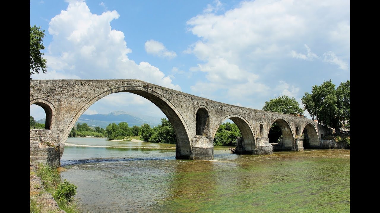
The bridge has been rebuilt many times starting with Roman or perhaps older foundations. The current one is probably a 17th-century Ottoman construction (1619). The folk ballad tells a story of human sacrifice during its building and a number of Greek proverbs arose associated with the interminable delays in its construction.
Monument of Zalongo, Preveza area. After years of battle with Ali Pasha, the people of Soule finally capitulated in 1803 with a truce. Ali Pasha broke his word and attacked them at Zalongo. Some of the villagers escaped, others found refuge in a monastery and 60 women and children jumped off the cliff of Stefane rather than be captured. It was an 11km drive each way from the south with the last 4kms a steep climb to the parking area beside a convent. It took me 13 minutes to climb the lovely cobble stairs/path to the top of the mountain where the monument sits. It is well worth the climb, not only to see the wonderful sculpture but also for the huge views to fields/olive groves to the east and the Aegean coast to the west. The monument is a curving white limestone block of two women, a teenager and 3 conjoined children, all holding hands. Construction started in 1950, and it was unveiled in 1961. I descended in 7 minutes.
Archaeological site of Nikopolis. This tentative WHS: (16/01/2014), is a Roman city built by Octavia Augustus in 29-27 BC near Cape Actium and the seaport city of Anectorium to hold the Actian Games, a competition held every 4 years to honour Apollo Aktos. Of importance similar to the Olympic Games, the competitions attracted competitors from all over the Greek Islands, Asia Minor, Syria and Egypt. The games lasted until 216 AD, when Christianity was taking hold. The winners got no money but crowns. The site was abandoned in the 11th century, and the locals plundered the stone. Stadium. The elliptical stadium held mock naval battles, chariot races, horse races, discus, javelin and running races (short to long-distance) for men, pubescent boys and young boys. All that remains is a crumbling gate, the grass’s floor” and bush-covered hillsides. Theatre. Held concurrently in the theatre were competitions for gymnastics (apparently in the nude), poets, comedians, pantomime, musical instruments (lyre, trumpet and flute) and tragedies. With room for 5000 spectators, the basic structure remains with crumbling upper walls, no seats, and parts of the monumental, rectangular stage (construction was rubble with brick facing). The active renovation was ongoing when I was there and the theatre area could not be entered. Free
I then had a 2+ hour drive to the Gulf of Corinth following the west and south shore of a great inlet. Nafpaktos town and Orini Nafpaktia villages. In the NM “Sights” series, this is a pleasant town on the north shore of the huge Kolpos Inlet that separates mainland Greece from the Peloponnese Peninsula (connected by a narrow land bridge near Athens). It has a castle on the hill, a crumbling fort on the water and along the shoreline.
GREECE – MACEDONIA, THESSALY & THRACE April 8-14, 2018
From the Memorial of Leonidas and Sparta at Thermopylae, I returned to the northern part of Greece: Macedonia, Thrace, Epirus and Thessaly.
Trikala. In the NM “European City” series, again I found little to distinguish this city.
METEORA The World Heritage-listed Meteora is an extraordinary place, easily the best natural wonder of the country, and one of the most visited in all of Greece. The massive pinnacles of smooth rock are ancient and extremely varied. The monasteries atop them add to this strange and beautiful landscape.
From the 11th century, hermit monks lived in the scattered caverns of Meteora. By the 14th century, the Byzantine power of the Roman Empire was on the wane and Turkish incursions into Greece were on the rise, so monks began to seek safe havens away from the bloodshed. The inaccessibility of the rocks of Meteora made them an ideal retreat. The earliest monasteries were reached by climbing removable ladders. Later, windlasses were used so monks could be hauled up in nets. A story goes that when curious visitors asked how frequently the ropes were replaced, the monks’ stock reply was ‘when the Lord lets them break’. These days, access to the monasteries is by steps that were hewn into the rocks in the 1920s, and by a convenient back road.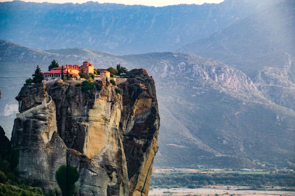
Kalambaka (pop 8000). The gateway to Meteora, is almost entirely modern, having been burned to the ground by the Nazis in WWII. It takes at least a day to see all of the monasteries of Meteora, so you’ll need to spend the night either in Kalambaka or the village of Kastraki. Kastraki (pop 1500). Less than 2km from Kalambaka, its impressive location right under the rocks gives a better feel. If you want a base for exploring the Meteora monasteries, or for climbing the rocks themselves, this is a good choice. MONASTERIES. Before setting out, decide on a route. If you start early, you can see several, if not all, mones (monasteries) in one day. The main asphalt road surrounding the entire Meteora complex of rocks and monasteries is about 15km; with your own transport, you can easily visit them all. Alternatively, take the bus that departs from Kalambaka and Kastraki. That’s enough time to explore three monasteries – Moni Megalou Meteorou, Moni Varlaam and Moni Agias Varvaras Rousanou. Perhaps the best route is to take the bus one way to the top and then work your way down and around on foot, finishing at either Moni Agiou Nikolaou on the Kastraki side, or at Moni Agios Triados on the Kalambaka side. Keen walkers should definitely explore the area on foot on the old and once-secret monopatia (monk paths). Entry to each monastery is €6, and dress codes apply: no bare shoulders are allowed, men must wear trousers and women must wear skirts below the knee (wrap-around skirts are generally provided at the entrances).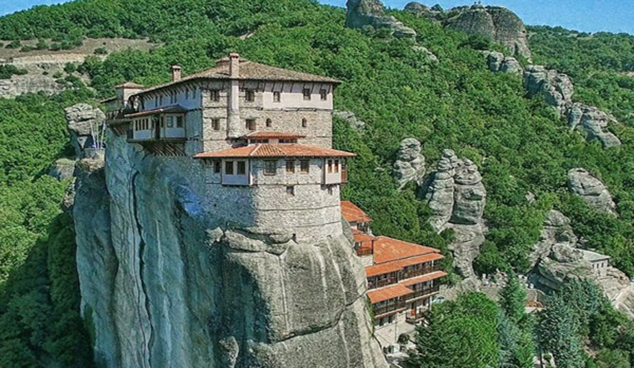
Moni Agiou Nikolaou. The nearest moni to Kastraki, is just 2km from the village square to the steep steps leading to the moni. The monastery was built in the 15th century, and the exceptional frescoes in its katholikon (principal church) were painted by the monk Theophanes Strelizas from Crete. Especially beautiful is the 1527 fresco The Naming of Animals by Adam in Paradise.
Moni Varlaam. About 700m down from Moni Megalou, Moni Varlaam has a small museum, an original rope basket (until the 1930s the method for hauling up provisions and monks) and fine late-Byzantine frescoes by Frangos Kastellanos. For a panoramic break, visit the rambling Psaropetra lookout, 300m east of the signposted fork northeast of Moni Varlaam.
Moni Agias Varvaras Rousanou. Access is via a small wooden bridge. The beautiful coloured glass–illuminated katholikon is the highlight here, with superb frescoes of the Resurrection and Transfiguration. The imposing steep structure of Rousanou is itself a stunning accomplishment and is today home to an order of 15 nuns.
Moni Agias Triados. This has the most remote feel about it, plus the longest approach. It was featured in the 1981 James Bond film For Your Eyes Only. The views here are extraordinary, and the small 17th-century katholikon is beautiful, in particular the Judgement of Pilate and the Hospitality of Abraham. A well-marked 1km monopati leads back to Kalambaka.
Moni Agiou Stefanou. After the austere Moni Agias Triados, this has efficient nuns selling religious souvenirs and DVDs of Meteora. Among the exhibits in the museum is an exquisite embroidered picture of Christ on his epitafios (bier). The monastery is at the very end of the road, 1.5km beyond Agias Triados.
LARISA. A NM “European City”,
Diachronic Museum of Larisa
PELION PENINSULA. I didn’t go here but include it for completeness’s sake – drive SE of Larisa to access it. The Pelion Peninsula, a dramatic mountain range whose highest peak is Pourianos Stavros (1624m), lies to the east and south of Volos. The largely inaccessible eastern flank consists of high cliffs that plunge into the sea. The gentler western flank coils around the Pagasitikos Gulf. The interior is a green wonderland where trees heavy with fruit vie with wild olive groves and forests of horse chestnut, oak, walnut, eucalyptus and beech trees. The villages tucked away in this profuse foliage are characterized by whitewashed, half-timbered houses with overhanging balconies, grey slate roofs and old winding footpaths. Many lodgings in the Pelion are traditional arhontika (stone mansions), tastefully converted into pensions and better priced. The peninsula has an enduring tradition of regional cooking, often flavoured with mountain herbs. Local specialties include fasoladha (bean soup), kouneli stifadho (rabbit stew), spetsofaï (stewed pork sausages and peppers) and tyropsomo (cheese bread). Volos. A NM “European City”.
Milies. A NM “small town”
Mount Pilion Scenic Railway
Potoki Beach.
Falostra Beach.
Ampelakia, A NM “Villages and Small Towns”, is a 5km steep climb (10 switchbacks) up the mountain to a cute little pedestrianized village. I walked along the one street keeping my eyes peeled to the ground to dodge all the dog shit. Reach a lovely leafy square with several sidewalk restaurants. I then paid a toll to drive on a 60km/hr secondary road that paralleled the expressway – only in Greece.
Platamon Castle, Platamon. This crenellated castle sits above Platamon Beach. Walk up a gravel road and a stone path to access. Inside is a large restored hexagonal keep, a small museum and mostly an overgrown park. €2
Palaios Panteleirmonas (“City of East Olympos”). 6 km off the highway, this tiny mountain village on the lower slopes of Mount Olympus appears to be a community of holiday homes (there was no evidence that anyone lives here year-round – all the houses were shuttered). But there is a church and one restaurant that I could find. The views of snow-covered Mt Olympus and down to the coast heading north were stupendous. Mount Olympus NP. The broader region of Mount Olympus is a tentative WHS (16/01/2014).
Dion village. A NM “sight”, the only attraction appeared to be the stone church with red brick accents – dated 1974. It was surprisingly closed but I could look in the windows – the entire interior was frescoed with mosaic halos. A tiny “replica chapel” sits on the corner, also completely frescoed.
Katerini. A NM “European City”
Instead of taking the recommended long way on bigger roads, I took the “direct route” on a twisty, pot-holed, narrow route, but it went along the top of the ridge of the west for good views down to the plains and fields in this part of Greece.
Archaeological Site of Aigai – Macedonian Royal Tombs (modern name Vergina). In the town of Vergina, don’t miss this – the museum is spectacular. It is a World Heritage Site. Philip II was a descendent of the Kings of Termeros of Argo, direct descendants of Hercules. Aigai was the capital of the ancient kingdom of Macedonia. He came to the throne of Macedonia in 359 BC when Macedonia was weak, poor and disordered. He was a great politician, diplomat and general and completely revived the country, paving the way for his son, Alexander the Great to conquer most of the known world at the time. At the height of his power, he was assassinated in the theatre at Aigai just as he was preparing for the wedding of his daughter. Alexander organized the greatest funeral of the time. He was cremated, his bones collected and placed in a great gold chest and interred along with 3 suits of the finest armour, a shield and complete set of weapons, a wonderful wreath of oak leaves, a beautiful set of silver dinnerware and a couch of ivory and wood decorated with statues and glass (Tomb #1). Buried in a separate tomb was one of his wives – she also was cremated and her remains were placed in a gold chest accompanied by a diadem of gold, a set of silver and a similar couch (Tomb #2). Both tombs, along with Tomb #4 (this was looted and little is known of the occupant) and Tomb #3 (the Prince’s Tomb – probably Alexander IV, the 13-16-year-old son of Alexander the Great and Roxane born in 323 BC and died in 310, a few months after Alexander and his grandmother were assassinated by Cassander in Amhibolis) were under a great tumulus 40m in diameter and 12m high, the largest burial mound in mainland Greece. The tumulus fill contained a large number of broken gravestones of ordinary citizens, most with their names on them. These Macedonians had Greek names confirming that Macedonians were a Greek tribe. The archaeological site and museum consist of two tunnels (an entrance and exit) cut into the tumulus with wonderful displays of all the contents of Philip’s, his wife and Alexander IV’s tombs inside. The explanations were terse. €12, €6 reduction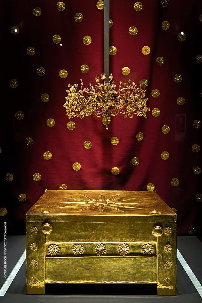
I was the only person here when I went – both nice but odd for such a great attraction. Monastery of St John the Baptist (Holy Monastery of Prodromos). About 11 km west of Vergina, the monastery sits above a reservoir filling a lovely canyon with rugged rock walls. Dating from 1296-1359, the church is a small rectangle with frescoes covering the walls and geometrics on the ceilings, all appearing freshly painted. There is a lovely icon of the Madonna and Baby surrounded by 24 small bible stories. The outside walls are under a porch and are also completely covered in frescoes. Next to the church is a nice 2-spout fountain, several caves cut into the basalt cliff and the monastery. I had originally planned on going to Thessaloniki after Aigai but counted up the days before I had to be in Istanbul to meet Anna at the airport, and realized I had time to spare, so headed towards western North Macedonia by way of Albania.
KOZANI. A NM “European City”, again I found nothing of much interest here.
Folklore and Natural History Museum. This museum is a real hodge-podge of local art, fossils, stuffed animals and ethnology, all in Greek. €3
Kastoria. A NM “small town”, it sits in a very attractive setting on a lake beneath some high deforested hills. North Kastoria lies on a peninsula jutting into the lake. It seems the entire town’s economy is orientated to the fur business. Go figure. There were so many large, high-end offices and stores, that I lost track.
The Area of the Prespes Lakes: Megali and Mikri Prespa which includes Byzantine and post-Byzantine monuments (16/01/2014)
Prespa National Park.
I returned to Albania for a few hours, mostly to see the Lake Prespa area, plus to spend all the Albania money I still had to buy gas. However, when I arrived, the border guard said my vehicle insurance was invalid in Albania. So I had to buy Albanian car insurance for €49 for 15 days (even though I only planned on being here for 24 hours). I had driven through Albania for the first time with no car insurance (the border did not notice that Albania was checked off). The insurance would accept only cash so I used all my gas money (I had €50 worth of Albanian money) to buy insurance. I returned to Greece from North Macedonia on April 11 to go to the Thessaloniki area.
Edessa Falls. This waterfall is on the edge (literally) of the city of Edessa. Drive through town to the area above the falls, a series of walkways, bridges and viewpoints at the top of the falls. They look very dramatic but you can’t see the bottom. The small river disappears into a series of concrete channels and a small lake. Unfortunately, I did not try to find the bottom and see the falls from below.
Balkan Wars Museum. About 35 km NW of Thessaloniki, this museum is part of a very attractive set of yellow/red-trimmed buildings. The Balkan Wars consisted of two conflicts that took place in the Balkan Peninsula in 1912 and 1913. The First Balkan War had three main causes: 1. The Ottoman Empire was unable to reform itself, govern satisfactorily, or deal with the rising ethnic nationalism of its diverse peoples. 2. The Great Powers quarrelled amongst themselves and failed to ensure that the Ottomans would carry out the needed reforms. This led the Balkan states to impose their own solution. 3. Most importantly, the Balkan League had been formed, and its members were confident that it could defeat the Turks.
First Balkan War. Four Balkan states defeated the Ottoman Empire in the first war. By the early 20th century, Bulgaria, Greece, Montenegro and Serbia had achieved independence from the Ottoman Empire, but large elements of their ethnic populations remained under Ottoman rule. In 1912 these countries formed the Balkan League. The First Balkan War began when the League member states attacked the Ottoman Empire on 8 October 1912 and ended eight months later with the signing of the Treaty of London on 30 May 1913.
Second Balkan War. The main victor of the four, Bulgaria, fought and pushed back all four original combatants of the first war along with halting a surprise attack from Romania from the north in the second war. The Second Balkan War began on 16 June 1913. Both Serbia and Greece, utilizing the argument that the war had been prolonged, repudiated important particulars of the pre-war treaty and retained occupation of all the conquered districts in their possession, which were to be divided according to specific predefined boundaries. Seeing the treaty as trampled, Bulgaria was dissatisfied over the division of the spoils in Macedonia (made in secret by its former allies, Serbia and Greece) and commenced military action against them. The more numerous combined Serbian and Greek armies repelled the Bulgarian offensive and counter-attacked into Bulgaria from the west and the south. Romania, having taken no part in the conflict, had intact armies to strike with, and invaded Bulgaria from the north in violation of a peace treaty between the two states. The Ottoman Empire also attacked Bulgaria and advanced in Thrace regaining Adrianople. In the resulting Treaty of Bucharest, Bulgaria lost most of the territories it had gained in the First Balkan War in addition to being forced to cede the ex-Ottoman south-third of Dobroudja province to Romania.
Effects of Balkan Wars. The conflicts ended catastrophically for the Ottoman Empire, which lost the bulk of its territory in Europe – all its European territories to the west of the River Maritsa, which thus delineated present-day Turkey’s western border. A large influx of Turks started to flee into the Ottoman heartland from the lost lands. By 1914, the remaining core region of the Ottoman Empire had experienced a population increase of around 2.5 million because of the flood of immigration from the Balkans Austria-Hungary, although not a combatant, became relatively weaker as a much enlarged Serbia pushed for the union of the South Slavic peoples. Citizens of Turkey regard the Balkan Wars as a major disaster in the nation’s history. The unexpected fall and sudden relinquishing of Turkish-dominated European territories created a psycho-traumatic event amongst many Turks that triggered the ultimate collapse of the empire itself within five years. Nazım Pasha, Chief of Staff of the Ottoman Army, was held responsible for the failure and was assassinated on 23 January 1913 during the 1913 Ottoman coup d’état. It is estimated that that in the first and second Balkan wars there were 122,000 killed in action, 20,000 dead of wounds, and 82,000 dead of disease.
THESSALONIKI Paleochristian and Byzantine Monuments of Thessalonika are World Heritage Sites, including 15 churches, the remnants of the wall and the Heptapryigion. Railway Museum of Thessaloniki. This open-air museum has 3 boxcars used to carry Jews to Auschwitz, 2 decrepit Orient Express cars (hold a theatre here sometimes), steam locomotives, boilers, different track gauges and switching equipment, tools and a museum in a WWII-era train station. Free
Church of St. Nicholas Orphanos. A 14th-century Byzantine church with faded frescoes. I entered at mass.
Naps 12 Apostolon (Church of St Catherine). Another grand Byzantine church.
Church of Panagia Chalkeon. Below street level, there is an elevator to get some people down. I entered at the end of mass with the heavy smell of incense in the air. There were a few faded frescoes in the entrance, many icons in intricately carved wood frames, a giant brass octagonal chandelier and at least 14 oil lanterns hanging from the ceiling. A guy had a stepladder to put out the many candles in more hanging lights. Free Agios Dimitrios Church. Easily the most visited church in Thessaloniki, this was packed with school groups and a few tourist groups. It is a big church with 2 aisles on each side, a balcony on three sides, a marble bishop’s chair, a pulpit, an altar screen, columns and Corinthian capitals. The few frescoes are very faded as most were destroyed in a fire in 1917. The most revered objects are the reliquary to St Dimitrios (jewelled crown sitting on a silver casket, the marble canopy was destroyed by the Saracens in 904 and by the Normans in 1118), an icon to him at the front (gets a lot of crossing and kissing, even by many teenage boys) and a reliquary to St Anyssia (an early Christian who refused to worship the pagan gods and was lanced by a soldier, her grave was not discovered until 1980, bones in a silver chest). Free
Modiano Market. This busy market is downtown and sells almost everything: clothes, 15 kinds of olives, 8 kinds of feta, veggies, flowers, meat, fish (all very small fish, all that is probably left in the fished-out Mediterranean) and a few restaurants – quite atmospheric. Hagia Sophia Cathedral. Built in the middle of the 8th century on the ruins of an early Christian 5-aisled basilica, this was Thessaloniki’s cathedral until 1524 when it was converted to a mosque of the same name. It was returned to Christianity in 1912 at the dissolution of the Ottoman Empire. It is a domed Greek cross basilica reflecting the architecture of Constantinople. Its mosaics date to 780-85. The famous frescoes are the 9th century Virgin Mother with the holy child in the apse and the Ascension of Christ in the dome. The few remaining frescoes of saints from the 11th century are on the west wall. After a disastrous fire of 1890, the Turks replaced the marble capitals with plaster ones and the frescoes with faux marble and geometrics covering all the walls. The highlight for me was the two enormous brass chandeliers with 24 winged dragons. An icon in the front got a lot of attention with several bowing on their knees, Free
Metropolitan Cathedral of St Gregorius Palamos. Not in the NM series, this 1891-1914 church was the nicest of them all with fresh frescoes replacing the ones destroyed in the 1978 earthquake.
Museum for the Macedonian Struggle. Resistance to Ottoman rule resulted in revolts in 1821, 1822, 1834-5, 1837-41, 1854-6, 1877 and 1896, all resulting in failure for the Greeks. Under Ottoman rule, Greece was primitive, agricultural and heavily taxed resulting in extensive migration of Greeks to Bulgaria and the USA. The museum was housed in the Greek Consulate building, the secret headquarters of the struggle. After 1912, Macedonia had an economic resurgence with improvements in diet, education and newspapers. But Macedonia became mired in the Balkan Wars primarily against Bulgaria in 1913 and then WWI happened with several German zeppelin attacks. The museum gives a great history of the guerilla fighters.
I then walked along the nice promenade next to the water, passing the White Tower, a great round, crenellated tower on the water, part of the original 8kms of walls that surrounded Thessaloniki up to the Heptapyrgion at the top of the town.
Alexander the Great Statue. Sitting on a horse rearing up on his hind legs, this is a great bronze monument to the conqueror of the known world when Alexander in a few short years completely conquered all Persian lands before dying at age 32 in 323 BC. Beside the statue is a nice bas-relief of Alexander fighting the Persians and 7 brass shields on lances.
Museum of Byzantine Culture. The continuation of the Eastern Roman Empire occurred when the capital was moved to Constantinople in 330 AD by Constantine the Great. Early Byzantine Empire (4th-7th centuries, continuation of Roman-style administration, Latin language); Middle Byzantine Empire (8th – 12th century, empire reduced to the south Balkans and Asia Minor, Greek was the language) and Late Byzantine Empire (13th century to 1453, multiple assaults from the Venetians, Latins, and Slaves before finally being conquered by the Ottomans). This ushered in four centuries of material destruction and social and economic backwardness. In 11 rooms, all aspects of Byzantine culture are exhibited. A temporary exhibit relates to the Ottoman defences of Macedonia. Constantinople was protected on three sides by sea with strong currents and required only a 6km triple wall with an 18m trench to fortify it on the land side. The Egnatia Road connected Thessaloniki to Constantinople. Besides Thessaloniki, there were extensive fortifications at Retina and Cassandria. €16, €8 reduced as a combination ticket with the Archaeological Museum, White Tower, Museum of the Roman Forum and Arched Wall of Galerian Complexes.
Archaeological Museum of Thessaloniki. Exhibits from prehistory to Roman times. There is a great exhibit on gold with explanations of all the archaeological discoveries over the centuries, primarily gravesites.
Macedonian Museum of Contemporary Art (MOMus). Exhibits Macedonian artists, some actually interesting. Only the permanent exhibit on the lower floor could be seen. Free
Heptapyrgion. This fort at the height of land above Thessaloniki has 7 towers. There are many remnants of the 8 km of walls that once surrounded Thessaloniki in the upper town. I was badly in need of a shower in the most shower-challenged country in Europe (showers are the biggest difficulty of travelling in a camper van with no bathroom). Service centres on major highways that cater to truckers have no showers., unlike the rest of Europe. Campgrounds were not open in mid-April and most of these mom-and-pop operations don’t sell showers to non-campers so one must resort to sneaking in. I had used marinas that cater to visiting sailboats once before and went to the Yacht Club of Thessaloniki. On a Saturday morning, the rowing club was a hub of activity, the easily accessible showers were hot and I was the only one using them – glorious. Archaeological site of Philippi. History. In 360 BC, colonists from Thassos founded a city here. Phillip II of Macedonia captured it in 356 and renamed it after himself. The fortified walls, theatre and public buildings were built. The Via Egnatia passed through in the 2nd century. After the great battle in 42 BC between the Romans who wanted to preserve the republic versus those that favoured Augustus occurred here, veteran Roman legionnaires loyal to Augustus settled here renaming it Colonia Augusta Julia Philippensis. They built the forum and many buildings. In 49/50 AD, the Apostle Paul visited and formed the first Christian community in Europe here. It became a great Christian pilgrimage city and during the 4th-6th centuries, on the site of the Roman buildings, three large basilicas and the Octagon complex (312-343 AD) were built dedicated to St Paul. By the early 7th century, natural disasters and invasions led to the abandonment of the lower part and the higher part of the city became a fortified city, remaining militarily important with its location on the main east/west road between Greece and Turkey, precious metals, timber and good agricultural land on the SE plain of Drama. Turkey conquered it in the 14th century, after which it was completely abandoned. The highlight buildings remaining are: Theatre. Initially built by Philip, the Romans enlarged it with a 3-story stage and used it for animal fights. The performances stopped with the Christians and an earthquake destroyed the city in the 7th century and is was systematically dismantled. Forum. Built in 31 BC and enlarged later it was 148X70 metres, but was destroyed in a 337 earthquake. Basilica B has some remaining intact great stonewalls and capitals showing how immense these churches were. Octagon. Only the mosaic floor and foundation stones remain to indicate its shape. Phillippi was declared a World Heritage Site in 2006. bb
Kavala. This is a pretty seaside city with a Tobacco Museum. Ferries leave here for the island of Thassos. The highlight for me was the magnificent aqueduct.
Avdira. A NM “small town” that has little to see. It occupies a small rise in a flat agricultural area.
National Park of Nestos Delta and Lakes Vistonida-Esmarida. Drive on a causeway linking small islands and crossing several lagoons. I visited a tiny white/blue monastery on an island accessed by a long gangplank. A second bridge leads to a second church on a separate island. I passed a huge crowd leaving (tourists?). Mass was just ending in the church as a young priest did a staccato reading from a bible with 3 others standing beside him. The church was otherwise empty.
ALEXANDROUPOLI Inaugurated as a city in 1880, it is the largest town in Trace Province and the gateway to Turkey and the Balkans. It transportation system includes an International Airport, high-speed trains and the Egnatia Odo Highway. It has 25 km of coastline from Evros River Delta to Makie. I slept on the beach west of town. Police checked by documents in the morning.
Ethnological Museum of Thrace. This is in a 1899 nice stone, residence. The young museum woman was very keen to explain everything. There are great examples of many of the implements used in the agricultural life of the people. €3, Free reduced Lighthouse of Alexandroupoli. The Lighthouse of Alexandroupoli is perhaps the most distinctive part of the city and the emblematic landmark. The need to build the Lighthouse was imperative when the port of Alexandroupolis was a hub for all ships sailing to the Bosporus and the Black Sea from the Aegean. The first lighthouse was built by a French company and operated with acetylene. Later was operated with oil and turned into electricity in 1974. It has undergone alterations and improvements and the last renovation was in 2002. It has a height of 18 meters (60 feet) above the ground and 27 meters (88.6 feet) from sea level and emits three white flashes of light every 15 seconds. The light reaches a distance of 24 nautical miles, ie approximately 44 km.
Evros Delta. This wide flat delta is well known for its birdwatching.
Northern Evros province (Orestiada). This is the far east of Greece next to Turkey. The road follows the river boundary much of the way. It is a rural agricultural country with not much of interest.
Igoumenitsa On Dec 23-31, 2019 (stopping at Mt Athos on Dec 26), I drove through this entire long state of Greece in a couple of days to get to Igoumenitsa, the port city on the NW corner of the country. It is the access port to the Ionian Islands (Corfu) and the port of the Greece to Venice Ferry that I took on Dec 31-Jan 1, 2020. While waiting for the Venice ferry I parked in the lot of the ferry terminal for 2 days mooching the great free wifi. There is little to see in the town.
