
My first trip to Liguria was in February 2018. I only visited Genoa on that occasion.
I took the Flixbus from Barcelona to Genoa (14 hours, ~22€). Arriving at 21:30, I believed that the hostel was closed at 22:00 and had a mad walk from the bus depot to the hostel, but it stayed open later.
GENOA (pop 585,000)
Genoa is Italy’s largest seaport. The extensive old city is a tightly twisting maze of narrow lanes. Since hosting Expo 1992 and as the 2004 European City of Culture, the city has had a radical makeover, with its once tatty port hosting Europe’s largest aquarium and a good maritime museum. The old town, too, had a revitalization with new shops, restaurants, and bars.
The metro is just one line, one of the shortest in Europe.
History. Founded in the 4th century BC, it was an important Roman port. The first ring of defensive walls was constructed in the 12th century, but only one part remains, the Porta Soprana. A victory over Venice in 1298 led to a period of growth, but then internal chaos led to one dynasty, the Grimaldis leaving to establish Monaco.
In the 16th century, Genoa benefited from Spanish exploration. Its coffers swelled further in the 17th century and an outer ring of walls was added. Its newly built palaces were filled with art, attracting masters such as Rubens and celebrated architect Alessi (1512-72) designed many of the city’s splendid buildings. The end of the Age of Exploration came as a blow with its mercantile importance declining.
Christopher Columbus is Genoa’s most famous son.
Genoa was the first northern city to liberate itself from Nazi and Italian fascists in WWII, even before Allied troops arrived. It then developed rapidly with southern Italians manning its docks and factories.
Sights. I took the Free Walking Tours that explored much of the old city.
Palazzi dei Rolli. These are Genoa’s tour de force. 42 of these lodging palaces were built between 1576 and 1664 to host visiting European gentry. A lottery was held to determine in which one you would stay. They were placed on the Unesco World Heritage list in 2006 and are mostly around Via Garibaldi and Via Balbi.

Palazzo Reale, the former residence of the Savoy dynasty is the one not to miss. It has gardens, furnishings, 17th-century art, and a gilded Hall of Mirrors.
Via Garibaldi. This pedestrianized street was planned by Alessi in the 16th century and is lined with palaces of Genoa’s wealthiest citizens. Three of these hold the Musei de Strada Nuova with the city’s finest collection of masters – Canone violin made in Cremona in 1743, Van Dyck portraits, and Ruben’s Venus and Mars.
Cathedral di San Lorenzo (1118 and 16th century). This zebra-striped cathedral owes its existence to the poor quality of a British WWII bomb that failed to ignite in 1941 and still sits in the nave. Relics include the quartz platter that received John the Baptist’s head and a fragment of the True Cross.
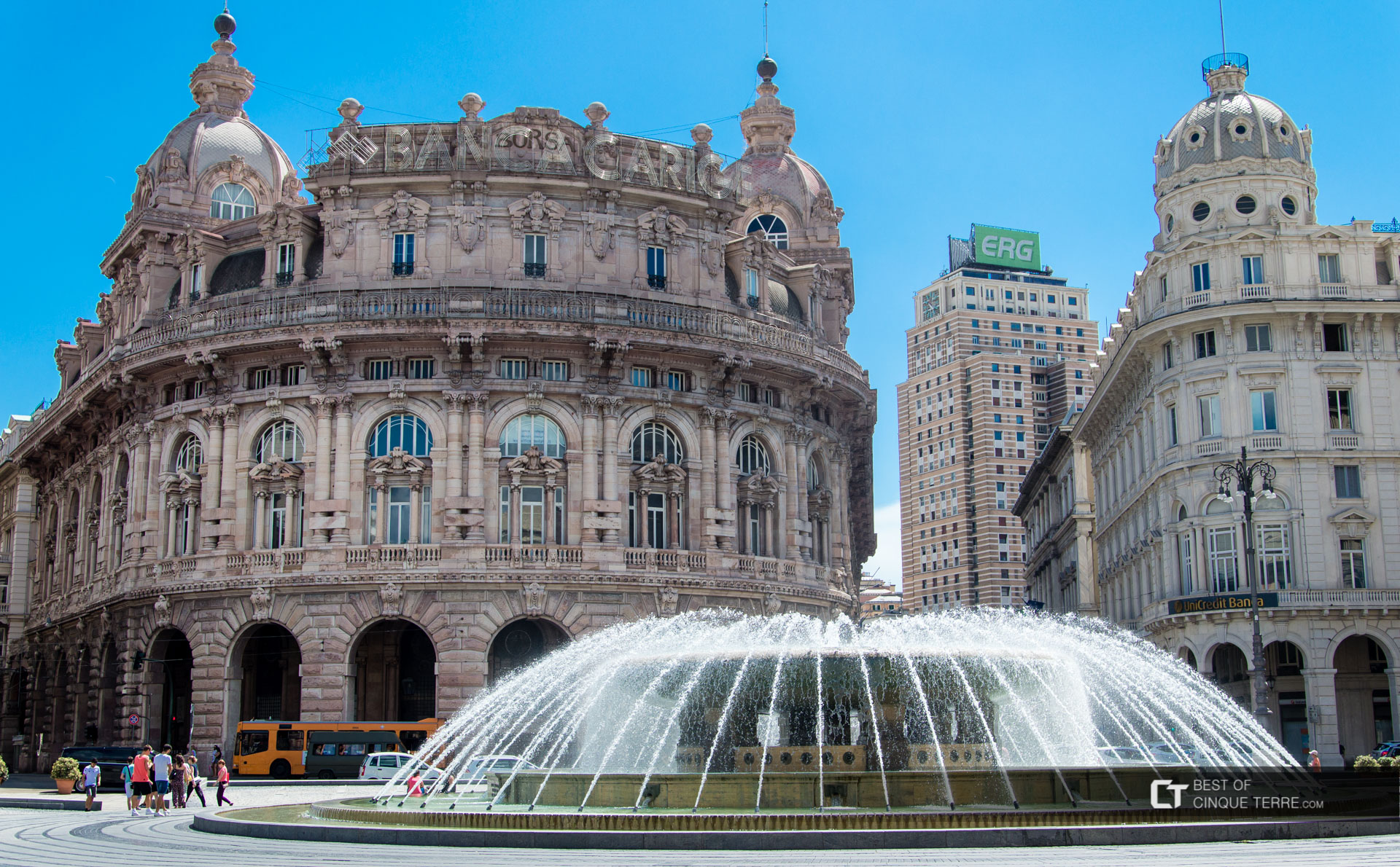
Plazza de Ferrari. Genoa’s fountain-embellished main plaza is ringed by magnificent buildings.
Old City. The heart of medieval Genoa, it is bounded by the ancient city gates Porta dei Vacca and Porta Soprana and the streets Via Garibaldi, Via Cairoli, and Via XXV. Our Free Walking Tours guide talked a lot about the street prostitution west of Via San Luca. It is famed for its narrow lanes. Walk up to a great square at the top of the Old Town for panoramic views. In the Old City is the Museo d’Arte Orientale (one of Europe’s largest collections of Japanese art) and Galleria Nazionale (Italian and Flemish Rennaissance art.
The Port. The Aquarium is the largest in Europe. Gelato Museo del Mare: because of its importance as a maritime power, the ‘Museum of the Sea’ is a large exhibit on Christopher Columbus. La Laterna, the lighthouse, dates from 1543 and is one of the world’s oldest and biggest with a lantern that can beam 50 km.
Trip 2. Liguria February 22-23 2019
On my second trip here, I was driving my van having left the Netherlands on Jan 14. I arrived from Province, France.
In Ventimiglia, just across the France border, I missed my first access to the expressway. There was a massive flea market happening and I was reminded to never drive the local roads for long. The entire 118 km to Savona would have been one continuous town. With local traffic, pedestrians, stop lights, and bicyclists, trying to drive near the water only leads to endless frustration. Besides you are rarely near the water, but a few blocks inland with only buildings to stare at.
Despite the exorbitant tolls (€14.60 or about €1.50 per 10 kilometres), this is the only way to go. These roads are high above the water to miss all the towns and surprisingly the views are good, both up to the mountains and down to the towns and the Mediterranean. Liguria, with its mountainous coastline, has spent a fortune on these highways – kept almost completely flat as the entire road is either on bridges or through tunnels.
The main problem may be the crazy Italian drivers who move at autobahn speeds. This road was 4-lane divided and two lanes were not enough for these guys to drive at these speeds. The right lane is full of big trucks going less than 100, so you move into the single left land with care. Italian drivers tailgate, cross the lane lines and are impatient.
Priamar Fortress, Savona. Built on a previous 1213 Castle de Santa Maria, this is a crumbling stone/brick fortress; its last addition is 1757-59 where the Archaeology Museum is.
GENOA
The Lighthouse of Genoa (Lanterna), is the main lighthouse for the city’s port. Besides being an important aid to night navigation in the vicinity, the tower serves as a symbol and a landmark for the City of Genoa. Built of masonry, at 249 feet (76 m) it is the world’s fifth tallest lighthouse and the second tallest “traditional” one. Between 1543 and the construction of the lighthouse on Île Vierge, France in 1902, it was the tallest lighthouse in the world. When measured as a whole with the natural rock on which it stands, as it is commonly perceived and represented, its height is 383 feet (117 m), which would make it the second-tallest lighthouse in the world, the tallest in Europe, and the tallest traditional lighthouse.
Rebuilt in its current shape in 1543 replacing the former lighthouse, it is the world’s third oldest lighthouse, following the Tower of Hercules in A Coruña, Spain, and Kõpu Lighthouse, on the island of Hiiumaa, Estonia.
The first tower at this location, a structure formed of three crenellated towers, was built around 1128. It was only in the seventeenth century that it became part of the walls of Genoa. It has remained a part of the system until today.
In 1840 a rotating Fresnel lens was installed and the entire lighthouse was modernized again in 1913.

Galata Museo del Mare. In the port, this maritime museum is highlighted with: Christopher Columbus and a life-size rowing galley moved by 100 rowers. The oars were 11m long and weighed 60 kg. €13, €11 reduced.
For another €2, see the WWII German submarine 518 in the harbour.
The aquarium of Genoa is the largest in Italy. Located in the old harbour area, it was originally built for Genoa Expo ’92 celebrating 500 years since the Genoan sailor Christopher Columbus discovered the new world. The original exhibition concept was to show the Ligurian Sea, the North Atlantic and Caribbean reefs “from two perspectives, one the New World/Old World encounter of 1492, the other the ecological awareness of 1992 and the present. The aquarium includes 70 tanks containing a total of 6,000,000 liters (1,300,000 imp gal; 1,600,000 U.S. gal), and almost 10,000 meters (33,000 ft) of exhibit space. €26, €23 reduction
LIGURIAN SEA CETACEAN SANCTUARY
Originally called the International Ligurian Sea Cetacean Sanctuary (Ligurian Sea Sanctuary), what is now known as the Pelagos Sanctuary for Mediterranean Marine Mammals is a Marine Protected Area aimed at the protection of marine mammals (cetaceans). It covers an area of approximately 84,000 km², comprising the waters between Toulon (French Riviera), Capo Falcone (western Sardinia), Capo Ferro (eastern Sardinia), and Fosso Chiarone (Tuscany).
The sanctuary is located in the Ligurian basin of the Mediterranean Sea. In this area, all the cetaceans occurring in the Mediterranean can be found at regular intervals. It is believed to be the main feeding ground for Fin Whales in the Mediterranean basin.
The sanctuary was established on 25 November 1999 and is the first (and currently the only) international / High Seas MPA in the world covering areas of the Mediterranean seas of France, Italy, and the Principality of Monaco. To underline the importance of the sanctuary, it has been added to the Specially Protected Areas of Mediterranean Importance (SPAMI) list of the 1999 Barcelona Convention.
Protected Marine Area. The Protected Marine Area of Cinque Terre National Park was founded in 1997 and preludes the National Park as an effort to protect and maintain proper usage of the sea off the coast of Cinque Terre. It is subdivided into 3 zones, a Strict Nature Reserve, where boaters are prohibited, the General Nature Reserve, which allows access to motorboats, registered retail fishermen and guided scuba diving tours, and the last and least stringent Partial Nature Reserve which allows monitored recreational fishing.
Pelagos Sanctuary. This part of the Ligurian Sea is included in the Pelagos Sanctuary for Mediterranean marine mammals, an international protected area that includes territories of France, Monaco, and Italy. Founded in 2002, The Pelagos Sanctuary focuses on the protection of Mediterranean cetaceans under threat from human involvement. In Italy, past practices included deep-net fishing and pollution from cruise ships that dock in areas like Cinque Terre, endangering the habitats of dolphins and other cetaceans that live in its waters. Goals are aimed at the protection of Pelagos cetaceans and their habitats and food ecosystems as well as the general biodiversity of the Mediterranean coast.
The coast along the Cinque Terre is characterized by high cliffs, caves, bays, tiny beaches, and cleft rocks. Marine life in the stretch of the coast which extends from Punta Mesco at Monterosso to Capo Montenegro at Riomaggiore is rich and varied. The steep faces of the cliffs underwater and the shallows and isolated rocks are populated by various kinds of gorgonia (sea fans), such as the colourful Leptogorgia sarmentosa and the white Eunicella verrucosa, a rare species in the Mediterranean, but fairly common along this part of the coast. The Posidonia oceanica, a plant that creates very important grass-like colonies, grows here and provides a safe habitat for the reproduction of many organisms. The steep rock faces of Punta Mesco and Capo Montenegro have the richest forms of marine life including rare species: the Eunicella verrucosa mentioned above, the rare Gerardia savaglia, or black coral. At a depth of only about 15/20 meters at Punta Mesco, unlike the rest of the Mediterranean, it is possible to discover the fans of the Paramuricea clavata or red gorgonia.
The main season is May to September. I could find no whale-watching trips until the end of March.
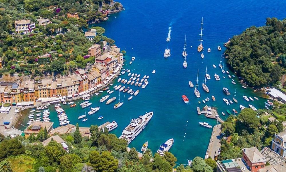
PORTOFINO (pop 500) This Italian fishing village and holiday resort is famous for its picturesque harbour filled with yachts and colourfully painted buildings that line the shore. A common day trip from Genoa, it has a historical association with celebrity and artistic visitors.
History. Pliny the Elder (AD 23 – AD 79) referred to Portus Delphini (Port of the Dolphin) as on the Ligurian coast between Genoa and the Gulf of Tigullio. Since the 1100s, the town’s natural harbour supported a fleet of fishing boats but was somewhat too cramped to provide more than a temporary safe haven for the growing merchant marine of the Republic of Genoa.
In the late 19th century, first British, and then other Northern European aristocratic tourists began to visit Portofino, which they reached by horse and cart from Santa Margherita Ligure. Aubrey Herbert and Elizabeth von Arnim were amongst the more famous English people to make the area fashionable. Eventually, more expatriates built expensive vacation houses, and by 1950 tourism had replaced fishing as the town’s chief industry, and the waterfront was a continuous ring of restaurants and cafés.
Castle Brown, a 16th-century castle converted in 1867 by the Brit, Montague Brown into a private mansion, has a famous tiled staircase and good views from the garden. Better views are 400m past it at the lighthouse.
The peninsula has 60 km of hiking trails, the best of which is the 15km coastal walk between Camogli and Santa Margherita via Santa Frutosso and Portofino. There are good train connections at both ends.
Statue of Christ of the Abyss was placed underwater on 29 August 1954 in the inlet at a depth of 17 metres (56 ft). This statue was placed to protect fishermen and scuba divers and in memory of Dario Gonzatti, the first Italian to use SCUBA gear, who died in 1947. Sculpted by Guido Galletti, it represents Christ in the act of blessing while looking up towards the sky with open arms in a sign of peace.
Church of St. Martin (Divo Martino, 12th century).
Church of St. George, housing some saints’ relics.
Oratory of Santa Maria Assunta, in Gothic style.

I slept at a service centre on the autostrada and discovered that these provide fast free wi-fi, both by the highways and the Autogrill.
CINQUE TERRE NATIONAL PARK is a protected area inducted as Italy’s first national park in 1999. Located in the province of La Spezia, Liguria, it is the smallest national park in Italy at 4,300 acres, but also the densest with 5,000 permanent inhabitants among the five towns. In addition to the territory of the towns of Cinque Terre (Riomaggiore, Manarola, Corniglia, Vernazza and Monterosso al Mare), the Cinque Terre National Park encompasses parts of the communes of Levanto (Punta Mesco) and La Spezia (Campiglia Sunsets). Cinque Terre was included as a UNESCO World Heritage Site in 1997.
The collection of five cliff-side towns on the Ligurian Coast linked by a series of trails highlights a delicate relationship between man and the environment. As a modification of the landscape has been so vital for the area’s development and tourist industry, the National Park is an essential tool in preserving and maintaining the natural landscape while promoting sustainable tourism that is vital to the economic success of Cinque Terre. To achieve its objectives, the Park Organization encourages the development of responsible tourism, able therefore to invest in the identity of the places and the territory’s products, and thus save its immense heritage of terracing, now endangered.
The Cinque Terre National Park was established on 6 October 1999 in recognition of the territory’s considerable scenic, agricultural, historical and cultural value. The five medieval towns along the Ligurian Coast provide scenic views of rugged terrain reeled in with terraced stone walls, where the mountains of ‘Appennino Ligure come straight to the sea. The form and disposition of the towns as they embrace topography embedded in the cliffs are a testament to the long history of settlement and the terraced cultivated lands to the agricultural heritage of the area. As the first Italian park created to safeguard a landscape that has been mostly built by humans, the Cinque Terre National Park and Protected Marine Area aim to protect the cultural heritage of “the park of Man.” The site’s location and topography are a vital part of the identity of Cinque Terre, whose extreme typological restraints and access to the coast inherently provide for a delicate relationship between man and the natural environment. That relationship has led to a dual existence, focused on both land and sea. For more than a thousand years, man has cut the steep slopes for terrace farming and vineyards while at sea maintaining a strong fishing culture. The beauty of Cinque Terre lies not in a pristine environment void of man, but rather the interplay of the two.
Known for its natural environment and coastal hiking trails, Cinque Terre is a tourist destination that draws people from all over the world, the numbers rising to 3.5- 5 million in August alone. While there is a great concern for the environmental effects of such numbers of visitors, tourism is essential, having long replaced farming and fishing as the area’s chief economy. Recognizing the value of sustainable ecotourism, the goal of World Heritage areas like Cinque Terre National Park is to maintain the ecosystem in a functional state by preserving the fine balance between tourism and agriculture.
Flora. Even though the Mediterranean flora has obvious features, there are many microclimates often different from each other which created a huge variety of landscapes. There are pine, Aleppo pine, corks, and chestnut. Rock and coastal environments produce numerous Mediterranean species such as samphire and sea cineraria. Flora is visible everywhere even as shrub rosemary, thyme, helichrysum, and lavender. Also present are several species of trees and succulents visible from many trails.
Fauna. The environment is conducive to the development of life and habitat of several animal species. Among the birds are the gull, the peregrine falcon, and the raven. Among the mammals are the dormouse, weasel, mole, badger, marten, fox, and wild boar (whose presence is resented for damage to crops). The reptiles that thrive in the rock are the common wall lizard, the lizard and various snakes such as the rat snake, the grass snake of Aesculapius, and the viper; around streams live amphibians like frogs and salamanders.
Land degradation. One of the greatest threats to the Cinque Terre region and one the National Park works to address is land degradation. Today, a large percentage of cultural heritage sites are classified by governmental authorities as exposed to landslide risk. In Italy in particular, whose terrain is 75% mountainous or hilly, 13/36 (36%) of heritage sites are affected by slope instability problems, including the Cinque Terre region.
The landslide activity of a region can be attributed to many factors. According to GNDCI, most current landslides in the Apennines are recently dormant, reactivated with climate change. While this explanation links the problem more to environmental and geological factors, mankind also plays a large role in the problem. Relevantly to Cinque Terre, changes in land use and agricultural practices have drastic effects on landslides and their outcomes. In a comparison of images of Cinque Terre land terracing in 1958 and 2000, there appears a clear increase in soil erosion and degradation of vineyard terraces that is consistent with agriculture abandonment in the 1960s as the main focus of the area shifted to tourism and away from the careful “landscape engineering” of previous centuries. According to city officials, in 1951, about 3,500 acres of Cinque Terre land were cultivated, compared to 275 today.
As land was already in a state of degradation in 2011, terrace abandonment is thought to be a contributing factor to the flash flood disaster of 25 October 2011. After 4 hours of uncharacteristic 22 inches of rain and subsequent flash floods, the towns of Monterosso al Mare and Vernazza were virtually destroyed. The other three cities, due to natural topography and effective draining systems, went mostly undamaged.
For these reasons, one of the foremost agendas of the National Park is the maintenance and revitalization of the slopes. The value in promoting terracing is two-fold, as it not only addresses landslide control but also recognizes the history and traditions of the villages by bringing back the traditional Cinque Terre vineyards. The “Uncultivated Lands” LIFE Project, co-founded in 2001 by the European Community and the Cinque Terre National Park, seeks to recover the unused terraces and to return them to their previous success for the production of Albarola and Vermentino vineyards.[13] One such hill, Corniolo, is featured as not only an educational tool for researchers interested in safe and effective cultivating practices but also as a “laboratory” to bring back the famed grapes that, in combination, shaped Cinque Terre’s reputation as wine producers in the Middle Ages. A sub-project, in cooperation with Agricultura Cinque Terre, seeks to do just that, by reintroducing some of the traditional ancient grapes of the region.
Ecotourism. The past three decades have seen significant tourism growth, in turn providing new economic opportunities for places like Cinque Terre. Ecotourism is a branch of the industry with immense benefits, as its aim is the enjoyment and appreciation of a natural landscape in an environmentally conscious manner. For tourists, there is often an expectation of a pristine untouched environment and an interest in the local population as a part of that landscape. In Cinque Terre, the greatest draw for tourists are the hiking trails and scenery among authentic traditional settlements. This socio-cultural element is essential as it highlights the heritage and culture of the picturesque Italian villages. Cinque Terre’s popularity can be attributed to the establishment of the park in 1999 and the addition to the UNESCO World Heritage Site, both of which embrace ecotourism and the need for sustainability. As a result of extensive efforts towards infrastructure, improvement of accessibility, and sustainable practices, the park has developed the site and increased its appeal on a global scale. While conservation policy can sometimes subordinate the environment and local interests in favour of promoting tourism, that is not the case in Cinque Terre, where there is such a large personal investment from the local population. Locals and park representatives work in tandem to understand and adapt to changing tourist needs while mitigating negative environmental consequences.
To maintain responsible and sustainable tourism within a community, certain criteria must be met. Foremost, tourism must be culturally appropriate. As a World Heritage Site, Cinque Terre embraces its traditions and culture and expands the tourist experience beyond a hike through the hills. The National Park makes a connection to the place with authentic customs, foods, and wines. Second, is the importance of land tenure and connection to the land, which Cinque Terre addresses with lifestyles that depend on both land and water. It is this strong connection to the environment that continues to bring tourists to these towns embedded perfectly in the coastal hills. Finally, what gives Cinque Terre so much potential for sustainable tourism are the local benefits that stretch beyond economics. As tourism is now so ingrained in the towns, the social benefits of interaction are evident and foster a sense of empowerment and pride that comes with caring for a protected land that millions enjoy.
These are not drive-to villages but are meant to be hiked between – only 12kms total. All are connected by train, easily the best way to see them if not hiking and the way to return to the start point of your hike. Cars were banned from all the towns 15 years ago.
They are known for their steeply terraced cliffs supported by low stone walls created 2000 years ago. The towns date from the early Medieval period with the oldest, Monterosso, founded in 648. Most of what is seen today is from the late Medieval period including several castles and parish churches. All are associated with Christian sanctuaries perched high on the cliff sides.
There are many trails within each town and two main ones connecting them. The two most popular are:
Sentier Azziero. Dating from the 12th century, this is a 12km old mule trail that before the train came in 1874, was the only way to get between the villages. Connecting all five, it is narrow and precipitous and several sections were severely damaged in floods in 2011.
Sentier Rosso. 36 km from Porto Venere to Levorno, it is mainly flat and in the trees.
Monterosso (pop 1530). The only village with a proper beach, it has an old and new half linked by a tunnel.
Vernazza (pop 865). Its small harbour is the only safe landing on the Cinque Terre coast. It has trademark narrow lanes to stunning views, castle ruins, and a church with a 40m octagonal tower.
Corniglia (pop 550). On top of a 100m cliff, it is the only one with no direct access to the sea. It has narrow alleys and colourful 4-story houses. It is possible to see all 5 villages in one panorama from here.
Mantaro (pop 950). Only 860m from Riomaggiore, it is known for its vineyards on its terraces.
Riomaggiore (pop 1645). In a steep ravine, it is the unofficial headquarters of the Cinque Terre with the park offices.
I missed the turn-off to Monterosso from the autostrada and had the craziest drive-about courtesy of Google Maps and a few bad decisions on my part. If you make a wrong turn, Google Maps instantly reroutes you – great in cities and one-way highways (the autostrada), but disastrous when she takes you on a 30km drive through the mountains to arrive at the same place you took the wrong turn in the first place!!! It is very difficult to judge scale and direction in such a long distance and impossible to determine elevation change. When I ended up on a one-lane mountain road, I turned around and took a route supposedly 10 minutes longer but not the one I made the error at. I switchbacked up to a high pass and descended steeply to arrive at Livorno, the town just north of Monterosso al Mar. Because of the heavy tourist traffic in the season, all the towns are pedestrianized. Don’t ask me where they all park. These towns cater to tourists with lots of restaurants and knick-knack stores. They also have an obligatory church.
Levanto. As isolated as the other 5 towns, it is another cute village on the water boxed in by cliffs on either side, a lovely spot to have lunch on the water. Only 1.8 km away as the crow flies, it was 15 km up over another pass to the first town on the north end of Cinque Terre, Monterosso. The road descending to the town was full of parked cars, On a Saturday, most people were hiking as the village was relatively empty. I walked down to the water; there was not much to see. Only a few km from Monterosso al Mar but 23 km by road up and over the mountains, a 35-minute detour off the road to Manarola.
I didn’t visit Corniglia or Riomaggiore (do you forgive me?) but drove Vernazza and then Mantaro.
La Spezia. This working port town has a nice park and walks along the west side, but the east side is an unattractive port and industry. It is the Italian Navy’s largest naval base. There were many sailboats out in the bay.
Portovenere (pop 4200). Again an NM small town, it is at the end of the peninsula west of La Spezia. It is known for its 8-story harbour front houses. It was originally a Roman base.
Tellaro. Another NM small town is 15 road kilometres south of La Spezia. With no beach, the houses on the shore all tumble down the cliff to above the rocks. Descend through narrow alleys to a stone sidewalk just under the houses that dead-end on each end. The town had few tourists on a Saturday.
==============================++==============================
Cinque Terre’s iconic ‘path of love’ is back. Don’t love it to death
Travellers can finally hike Italy’s Via dell’Amore again after a decade of restoration. Locals hope new rules for accessing it will encourage more responsible tourism.
But the Via dell’Amore has been closed since September 24, 2012—initially after a landslide, which was then compounded by wave damage in 2018. The full trail should reopen in July 2024. An initial stretch of it, starting from Riomaggiore, reopened on July 1 for a three-month preview. Now, this lovers’ lane is only accessible via guided tours.
Here’s why lawmakers are restricting access to the iconic path and how you can still enjoy Cinque Terre without harming it.
Fabrizia Pecunia, the mayor of Riomaggiore, came up with the new plan for the 3,215- foot-long path to combat overtourism. Last year, about three million tourists visited Cinque Terre, a fragile national park. In contrast, there are fewer than 4,000 residents left in the area.
“There’s an excessive pressure on residents. We have to try to find balance. If we just go after [tourist] numbers, we’ll implode,” says Pecunia. She says that many day-trippers arrive without knowing anything about the Cinque Terre. “They turn up, take selfies, eat a gelato, and go,” says Pecunia. “Often they think [Cinque Terre] is just colorful houses.”
(Should the world’s most iconic places be off limits due to overtourism?)
Contrary to popular belief, the Cinque Terre are not fishing villages. Farmers developed the area beginning in the 11th century, moving down from the clifftops as the threat of attacks by Saracen pirates decreased, and the need to transport their wine by sea increased.
In October 2022, the council closed Manarola’s ancient clifftop cemetery to the public after it became overrun with tourists. “They went to have picnics, models were doing photoshoots,” says Pecunia. “People were finding visitors setting up camp on the tombs of their grandparents.”
A path to responsible travel?
While Italian law doesn’t allow Pecunia to cap the number of visitors to her village, she can control entry to a specific place—like the Via dell’Amore. The path will be closed at night to prevent vandalism of the $25 million restoration project; CCTV will monitor its two entrances.
Access to the via will be free for locals during daytime opening hours. Out-of-towners can access the first 525 feet of the path until September 30 as part of a trial of the new reservation system. After securing a five euro slot online, up to 30 people can join each 30-minute, multilingual tour departing every half hour.
The Via dell’Amore reservation system is part of a larger bid to encourage more informed tourism to the Cinque Terre. The idea? Create a cultural circuit with the trail at its center. A small exhibition about the area’s vineyards has already been installed in Riomaggiore’s ancient castle; a gallery is in the works spotlighting 19th to 20th century artists who were inspired by the Cinque Terre.
(Learn how Italy aims to save an endangered ancient Roman superhighway.)
Pasini, Riomaggiore born and raised, is one of the Via dell’Amore guides. He says that before the path closed, the authorities regularly had to remove trash and padlocks clamped to the railings to symbolize love. “I saw indescribable things. One couple didn’t have a lock, so they’d improvised with underwear.”
Locals aren’t happy that the trail will close at night, but for Pecunia, turning the Via dell’Amore into a museum will contextualize this world-famous stretch of coast. “We can tell the story of Cinque Terre in a different way,” she says. “We have everything–culture, history, agriculture, landscapes, the sea—it’s unique.”
