
NAZARETH (pop 77,000)
The capital and the largest city in the Northern District of Israel. Nazareth is known as “the Arab capital of Israel” The inhabitants are predominantly Arab citizens of Israel, of whom 69% are Muslim and 30.9% Christian. “Upper Nazareth”, declared a separate city in June 1974, is built alongside old Nazareth, and had a Jewish population of 40,312 in 2014.
In the New Testament, the town is described as the childhood home of Jesus, and as such is a centre of Christian pilgrimage, with many shrines commemorating biblical events.
Grotto of the Annunciation.
Church of the Annunciation was established over the site where the Catholic tradition holds to be the house of Virgin Mary, and where angel Gabriel appeared to her and announced that she would conceive and bear the Son of God, Jesus – an event known as the Annunciation. For this reason, the site and the city of Nazareth are among the most sacred places in the Christian world.
The current church is a two-story building constructed in 1969 over the site of an earlier Byzantine-era and then Crusader-era church. Inside, the lower level contains the Grotto of the Annunciation, believed by many Christians to be the remains of the original childhood home of Mary.
The first shrine was probably built sometime in the middle of the 4th century comprising an altar in the cave in which Mary had lived. A larger structure was commissioned by Emperor Constantine I, also the Church of the Nativity (the birthplace) and the Church of the Holy Sepulchre (the tomb). Some version of it was known to have still been in existence around 570 AD, but it was destroyed in the 7th century after the Muslim conquest of Palestine.

St. Gabriel’s Church
On March 2, I joined three other travellers to rent a car to see the north eastern part of Israel. This is the most difficult part of the country to explore by public transport and this is the only practical way to do it.
SEA OF GALILEE. This is the largest fresh water lake in Israel at -244m below sea level. It has beaches, camp grounds and cycling and walking trails. Jesus spent most of his ministry around this lake. This is were it is believed to have performed some of his best-known miracles (the multiplication of loaves and fishes, walking on water) and where he delivered the Sermon on the Mount.
Belvoir Fortress (“Star of the Jordan”) is a Crusader fortress on a hill 20 kilometres (12 mi) south of the Sea of Galilee. Gilbert of Assailly, Grand Master of the Knights Hospitaller, began construction of the castle in 1168. The restored fortress is located in Belvoir National Park. It is the best-preserved Crusader fortress in Israel.
Following Saladin’s victory over the Crusaders at the Battle of Hattin, Belvoir was besieged. The siege lasted a year and a half, until the defenders surrendered on 5 January 1189. An Arab governor occupied it until 1219, 1241-63 – Franks, an Arab village, Kawkab al-Hawa, whose inhabitants fled during the 1947-48 civil war after a military assault by Yishuv forces. Israel: the Arab buildings on the site were demolished by the Israeli authorities between 1963 and 1968 – one of the best examples of ‘the eradication of all traces of an entire civilisation from the landscape’ in Israel.
It uses the concentric castle plan, widely used in later crusader castles. The castle was highly symmetric, with a rectangular outer wall, square towers at the corners and on each side, surrounding a square inner enclosure with four corner towers and one on the west wall. The castle was surrounded by a moat 20 metres (66 ft) wide and 12 metres (39 ft) deep.
Tiberias (pop 42,000)
The major city on the Sea of Galilee, it has little interest to tourists other than a lakeside strip of tacky 1970s resorts. It is one of the four holiest cities of Judaism and a popular base for Christians visiting all the nearby holy sites.
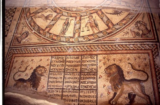
Hamat Tveriya NP. 2.5kms south of Tiberias, this is a 4th-century synagogue with a zodiac mosaic.
Ancient Boat. Discovered in 1986, this wooden boat came from the time of Jesus. It is 8km north of Tiberias. It did not look worth the 20S entry fee so we did not see it.
Church of the Transfiguration on Mt Tabor is traditionally believed to be the site where the Transfiguration of Christ took place, an event in the Gospels in which Jesus is transfigured upon an unnamed mountain – becomes radiant, speaks with Moses and Elijah, and is called “Son” by God.
The current church, part of a Franciscan monastery complex, was completed in 1924 built on the ruins of a (4th–6th-century) Byzantine church and a 12th-century Crusader church (three grottoes belonging to the Crusader church. Several mountains have been identified as the site of the Transfiguration but Mount Tabor was accepted in 348.
Tabgha. On the Sea of Galilee, Tahgha has two churches, the Church of the Multiplication of Loaves & Fishes (nice Byzantine mosaic floor) and the Church of the Primacy of St Peter (has a flat rock in front of the altar – Christ’s table – believed that Jesus and his disciples breakfasted on fish here).
Mount of the Beatitudes. This hillside Roman Catholic church has good views of the Sea of Galilee and sits on the site where Jesus delivered his Sermon on the Mount (Matthew 5-7) whose opening lines – the 8 Beatitudes – begin with the phrase ‘Blessed are”.
Capernium. This is believed to be Jesus’ home base during the most influential period of his Galilean ministry (Matthew 4:13, Mark 2:1 John 6:59) when he recruited some of his best-known apostles. The site contains a synagogue ruin, a modern, glass-walled church suspended over the ruins of an octagonal 5th-century church obscuring St Peter’s House, where Jesus is believed to have stayed and a Roman ruin. 18kms northeast of Tiberias.
UPPER GALILEE
Tsfat (pop 31,000). This mountaintop city is the centre of Kabbalah (Jewish mysticism) since the 16th century – home to Hasidic Jews and former hippies, many American immigrants.
Hula Valley. Once swamps notorious for malaria, the wetlands were drained destroying a crucial bird migration wetland. The Hula Nature Reserve is in the 10% of the wetland surviving.
Abuhav Synagogue is a 15th-century synagogue in Safed named after 15th-century Spanish rabbi and kabbalist, Isaac Abuhav who designed the synagogue and his disciples erected it in Safed when they arrived in the 1490s after the expulsion from Spain. It was almost completely destroyed in the 1837 earthquake.
Tel Dan Nature Reserve. On the Lebanese border, this forested area is fed by year-around springs (8 cubic meters per second) that feed the Dan River, the major source of water for the Sea of Galilee and thus the country of Israel.
We stopped here and hiked some of the trails (doing all of them might take an hour). There was a surprising amount of water for the small snow pack visible on Mount Hermon.
Metulla Canada Center has a handful of extreme options including Israel’s first Olympic-size ice rink, swimming pool, bowling alley, shooting range and the country’s second 7D Max Cinema – screening 10-minute films that take your mind on an extreme adventure via a sensory explosion that mashes a 3D movie experience with extra theatrical effects including simulated rain and wind, seat vibration and movement. Also mountain biking, riding in an open jeep or zipping down an omega line.
GOLAN HEIGHTS
Offering commanding views of the Sea of Galilee and the Hula Valley, the volcanic Golan plateau is a favourite destination for holidaying Israelis. Its fields of basalt boulders – and, on its western edge, deep canyons – are mixed with cattle ranches, orchards, vineyards and small, friendly communities.
Israel captured the Golan Heights from Syria during the 1967 Six Day War, when 90% of the inhabitants fled or were expelled. In the bitterly fought 1973 Yom Kippur War, Syrian forces briefly took over much of the Golan before being pushed back to the current lines.
Katzrin (pop 7000). The Golan’s only real town.
Gamla Nature Reserve. Has the excavated ruins of an ancient Jewish stronghold whose inhabitants leapt to their deaths rather than fall into the hands of the Romans in 67AD. Now known for its griffon vultures.
Yehudiya Nature Reserve. The star of Israel’s northern national parks, it has challenging hiking.
Banias Nature Reserve. In the NW corner of the Golan, this is the most popular nature spot in Israel. There are separate spring and a canyon/waterfalls sections separated by 2.5kms. We walked the trails up the canyon to the impressive double waterfall.
Nimrod Fortress. Built by the Muslims in the 13th century to protect the road from Tyre Lebanon to Damascus, this fortress occupies a long narrow ridge at 815m on the slopes of Mount Hermon.
Mt Hermon. This mountains 2814m summit is in Sryia; the highest point controlled by Israel is 2236m. With small patches of snow in early March, it has Israel’s only ski hill, and is visible from all over.
We had great views of Nimrod Fortress as we ascended to the top of the Golan Heights. The main town up here is Majdal Shams (pop 10,000), the largest of the Golan’s four Druze towns. Ten kms past is Odem and the Golan Heights Hostel, where we stayed for the night. A friendly place they have a nightly group meal.
Ghajar Alawite-Arab village on the Hasbani River on the border between Lebanon and the Israeli-occupied portion of the Golan Heights, internationally considered to be de jure part of Syria. In 2017 it had a population of 2,559.
History. In 1932, the predominantly Alawite residents were given the option of choosing their nationality and overwhelmingly chose to be a part of Syria, which has a sizable Alawite minority. Prior to the 1967 Arab-Israeli War, Ghajar was considered part of Syria and its residents were counted in the 1960 Syrian census. When Israel occupied the Golan Heights from Syria in 1967, Ghajar remained a no-man’s land and the villagers wanted to be part of the Israeli-occupied Golan Heights. In 1981, most Alawi villagers accepted Israeli citizenship but the unilateral annexation was not recognized by the international community. In 1978, Israel withdrew from Southern Lebanon and Ghajar expanded northward into Lebanese territory, subsuming the Wazzani settlement north of the border. In 2000 Israel withdrew their troops from Lebanon and in an attempt to demarcate permanent borders between Israel and Lebanon, the United Nations made the Blue Line – the northern half of the village came under Lebanese control and the southern part remained under Israeli control. This arrangement created much resentment among the residents, who see themselves as Syrian.
Residents on both sides of the village have Israeli citizenship; those in the northern half often hold passports from both Lebanon and Israel. They work and travel freely within Israel, but those living on the Lebanese side have difficulties receiving services from Israel. There is an Israel Defense Forces checkpoint at the entrance to the village, and a fence surrounding the entire village, but no fence or barrier dividing the two sides of the village.
The UN has physically marked the recognized border and Israeli soldiers remain on the Lebanese side of Ghajar. UNIFIL military observers patrol the area continuously. The Lebanese Armed Forces patrol the road outside the perimeter fence. As long as the Israel Defense Forces remain in northern Ghajar, Israel will not have completed its withdrawal from southern Lebanon in accordance with its obligations.
As we had to have the car back in Nazareth by 9am, we were on the road by 7 for the lovely drive back. We went around the Sea of Galilee to the east and south, drove over some mountains to Afula and then Nazareth and dropped the car off (total cost was 316S (US$75), expensive but shared four ways. The #331 bus to Haifa stopped outside the car rental station and we were in Haifa by 10am. The two Argentinians continued north to Acco and I walked the two blocks to my hostel for the night, the Port Inn. I then got the train north to Acco at 11:35, a great morning with great timing.
MEDITERRANEAN COAST
Stretching for 273kms from Gaza to the Lebanese border, this coastline has fine beaches, archaeology and dynamic cities and towns.
Akhzivland is a micronation near the ruins of Achziv, an ancient settlement on the Mediterranean coast 5 kms north of Nahariya founded by Eli Avivi in 1971. Club Med has had a resort here since the early 60s. In 1970, the Israeli government sent bulldozers to demolish Avivi’s home and in protest, Eli founded Akhzivland in 1971, setting up a hostel and a museum inside the former home of the mukhtar of Az-Zeeb. The micronation became a tourist site, a “hippy micro state” attracting artists, models, writers, politicians, and countercultural figures, including Shimon Peres, Bar Refaeli, Sophia Loren, and Paul Newman. For a certain time, visitors’ passports received a special stamp. A court ruled to lease the area to Avivi for 99 years. Akhzivland now contains a guest house, beachfront campground, and a museum of local findings from the sea and seashore.
Eli Avivi died of pneumonia on May 16, 2018.
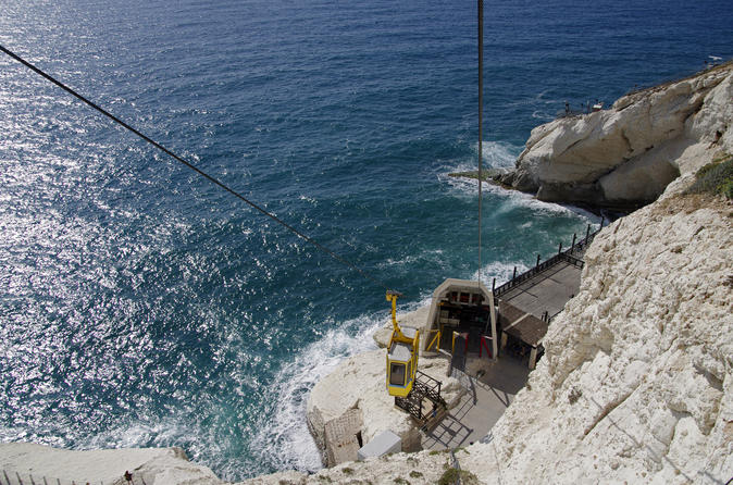
ROSH HaNIKRA (“Head of the Grottoes”) is a white chalk cliff face that opens up into spectacular grottos on the border between Israel and Lebanon.
Rosh HaNikra grottoes are 200m long cavernous tunnels formed by sea action on the soft chalk rock.

They branch off in various directions with some interconnecting segments. A tunnel was built by the British for the Haifa-Beirut railroad line, and in 1968 a second one was dug, both connecting the grottoes with each other and allowing access (currently: only exit) along the former route of the British railroad.
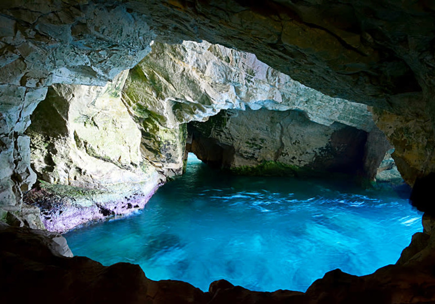
For many years though, the only access to the grottoes was from the sea and the native swimmers and divers were the only ones capable of visiting. The 400 meters long tunnel dug in 1968 between the grottoes and slightly above sea level improved the situation, and soon after a cable car was built to take visitors down from the top of the cliff to the tunnels. With a 60-degree gradient, this cable car is advertised as the steepest in the world.
A kibbutz, also named Rosh HaNikra, is located nearby. The Israeli city Nahariya is located about 10 km (6 miles) south of Rosh HaNikra.
Rosh HaNikra Islands are a group of three Israeli islands 800 meters offshore in the Mediterranean (water depth 7-9m) near Rosh HaNikra named Shalaf, Nahalieli and T’chelet. The Rosh HaNikra Islands are a part of a natural reserve, the only place in Israel where certain rare birds nest: the White wagtail, The European herring gull and the Common tern and boarding these islands is prohibited. In ancient days, these islands had a certain economic and commercial significance as they were a natural habitat for the sea snail from which Tyrian purple dye was produced.
ACCO (Acre pop 52,000)
Marco Polo passed through Akko around 800 years ago and the place hasn’t changed much since then. The city was awarded Unesco World Heritage status in 2002. The bus and train stations are roughly 2km – an easy walk – from Old Akko.
A visit to Old Akko begins by stepping through city walls – built by Ahmed Pasha al-Jazzar in 1799, right after Napoleon’s retreat – and into another century. Buy the combo ticket giving access to most sights at a reduced price.

Al-Jazzar Mosque. This mosque was built in 1781 in typical Ottoman Turkish style, with a little local improvisation in parts – the columns in the courtyard, for example, were ‘adopted’ from Roman Caesarea. Around by the base of the minaret, the small twin-domed building contains the sarcophagi of al-Jazzar and his adopted son and successor, Süleyman.
Subterranean Crusader City. The Knights’ Halls, a haunting series of vaulted halls that lie 8m below street level, served as the headquarters of the crusading Knights Hospitallers. It’s possible that Marco Polo dined in the Refectorium (Dining Hall) when he visited Acre. Opposite the entrance you can see a fleur-de-lys, an emblem of the kings of France.
Templar Crusader Tunnel. Near the lighthouse at the southern tip of Akko, look out for this amazing underground passageway, which connected the port to a Templar palace. You can enter at either end of the tunnel.
Treasures in the Wall Museum. With ethnographic items from the 19th century, most of them used by early Zionist farmers, this was a quaint museum in a gorgeous building part of the outside wall.
Okashi Art Museum. A gallery devoted to the works of Avshalom Okashi (1916–80), an influential Israeli painter and a resident of Akko. Most of his pieces were quite abstract and didn’t appeal to me much.
Souq. The usual stores selling lots of kitsch. I need a hat and the only ones available were well on the ugly side. But I couldn’t help having a look in several stores to hack their taste. Enter at either end of the tunnel (near the lighthouse or the Khan al-Umdan).
Khan al-Umdan. Old Akko has several large khans (an inn enclosing a courtyard, used by caravans for accommodation), which once served the camel caravans bringing in grain from the hinterland. The grandest is the Khan al-Umdan (Inn of the Pillars), built by al-Jazzar in 1785 (the pillars were appropriated from Caesarea). The ground floor housed the animals, while their merchant owners slept upstairs. The gate is locked and this site is not open but I could peer into the courtyard.
Harbour. The harbour’s marina is still very much in service and if you are around early enough, you can watch the fishing boats come in and unload the day’s catch.
Akko Light (Acre Light), is an active lighthouse on the SW corner of the city’s ancient walls, the former site of an Ottoman Flag Tower.
The station was established in 1864 and the current structure in 1912. It is a 33 feet (10 m) concrete tower in a black and white checkered pattern topped with a gray lantern room and a gallery. The light is visible for 10 nautical miles and is closed to the public, but there is a stone stairwell going down from the base directly into the sea.
Baha’i Gardens. These gardens, as well as a shrine called the Bahje House constitute the holiest site of the Baha’i faith. This is where Baha’ullah, a follower of the Bab and the founder of the faith, lived after his release from prison in Akko, and where he died in 1892. It’s situated about a kilometre north of the town centre on the main Akko–Nahariya road. I didn’t visit these as it was late in the day but intend to see the better Baha’i Gardens in Haifa. i didn’t go here.
HAIFA (pop 264,900)
Israel’s third-largest metropolis is one of the most picturesque cities in the Middle East, the mixed Jewish-Arab port of Haifa offers sweeping views of the sea and one of the most beautiful gardens in the world. The bus and train stations and the trendy German Colony are on the flats near the port. Head up the hill a bit and you come to the predominantly Russian Hadar district and the Arab commercial precinct of Wadi Nisnas. High atop Mt Carmel is the stylish Carmel Centre district, home to the university, exclusive residences, and trendy bars and eateries.

Mount Carmel is a 39 km-long coastal mountain range stretching from the Mediterranean as far in the southeast as Jenin. The range is a UNESCO biosphere reserve. The name is directly from the Hebrew word Carmel that means “fresh” (planted), or “vineyard” (planted). Mt Carmel also refers more specifically to the northwestern 19 km of the range and to the headland at the northwestern end of the range.
The Carmel range is approximately 6.5 to 8 kilometres wide, sloping gradually towards the southwest, but forming a steep ridge on the northeastern face, 546 metres (1,791 feet) high. The Jezreel Valley lies to the immediate northeast. The range forms a natural barrier in the landscape, just as the Jezreel Valley forms a natural passageway, and consequently the mountain range and the valley have had a large impact on migration and invasions through the Levant over time.
An admixture of limestone and flint, it contains many caves, and covered in several volcanic rocks. The sloped side of the mountain is covered with luxuriant vegetation, including oak, pine, olive, and laurel trees.
Several modern towns are located on the range: Yokneam on the eastern ridge, Zikhron Ya’akov on the southern slope, the Druze communities of Daliyat al-Karmel and Isfiya on the more central part of the ridge, and the towns of Nesher, Tirat Hakarmel, and the city of Haifa, on the far northwestern promontory and its base. Beit Oren is a small kibbutz on one of the highest points in the range to the southeast of Haifa.
Excavations show 600,000 years of human activity and in 2012, it was added to UNESCO as sites of human evolution at Mount Carmel: four caves (Tabun, Jamal, el-Wad, and Skhul) on the southern side of the Nahal Me’arot/Wadi El-Mughara Valley.
The Carmelites religious order was founded on Mount Carmel in the 12th century with a monastery dedicated to the Blessed Virgin Mary. The Carmelite Order grew to be one of the major Catholic religious orders worldwide. It was destroyed in 1821 and later constructed directly over a cave, the crypt of the monastic church, is termed “Elijah’s grotto”
Elijah’s Cave. Considered holy by Christians, Jews and Muslims alike, this grotto is where the prophet Elijah is believed to have hidden from King Ahab and Queen Jezebel after he slew the 450 priests of Ba’al (Kings 1:17-19). There is also a Christian tradition that the Holy Family sheltered here on their return from Egypt, hence the Christian name, Cave of the Madonna.
Stella Maris Carmelite Monastery. This neo-Gothic Carmelite church and monastery, with its wonderful painted ceiling, was originally established as a 12th-century Crusader stronghold. A hospital for the troops of Napoleon in 1799, it was subsequently destroyed by the Turks and replaced by the present structure in 1836.
Baha’i Gardens. Mount Carmel is considered a sacred place for Bahá’ís around the world, and is the location of the Bahá’í World Centre and the Shrine of the Báb. The location of the Bahá’í holy places has its roots in the imprisonment of the religion’s founder, Bahá’u’lláh, near Haifa by the Ottoman Empire during the Ottoman Empire’s rule over Palestine.
The stunning, immaculately kept multiple terraces of the dizzily sloped, perfectly manicured gardens are themselves alone a reason to visit Haifa. Designed by a Canadian of Iranian descent, they were finished in 2002. The centre of the gardens are formal, the immediate sides informal and the outsides forest. There are 9 terraces above and nine below the golden-domed Shrine of the Bab (there were 18 prophets). Each terrace has fountains, walkways, trees and flowers.The gardens are maintained by 100 gardeners, 2/3s professionals.
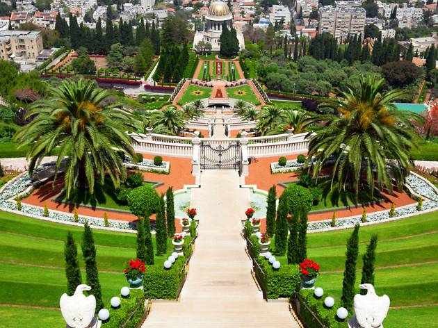

Apart from the top two tiers, the gardens – declared a Unesco World Heritage Site in 2008 – are accessible to the general public only on hour-long guided tours. There is one English tour per day (except Wednesday) departing at noon, three Russian tours per week starting at 11am and irregular tours in hebrew; be sure to arrive at 11.30am as it’s first come first served and only 60 people are allowed in daily. Meet at the appointed time at Yefe Nof St at the top of the garden. Completed in 1953, this tomb of the Baha’i prophet Al-Bab integrates both European and oriental design, and is considered one of the two most sacred sites for the world’s five million Baha’is (the other is the tomb of Mizra Hussein Ali in Akko). The best way to get here is by taking the Carmelit subway to the top stop and then walking to the top of the gardens.
The Haifa gardens also contain an International Teaching Center, the International Baha’i Archives (built in 1957, this Greek style building has classical Mediterranean architecture.
BAHA’I. Founded in the middle of the 19th century, the Baha’i faith (www.bahai.org) believes that many prophets have appeared throughout history, including Abraham, Moses, Buddha, Krishna, Zoroaster, Jesus and Mohammad. Its central beliefs include the existence of one God, the equality and unity of all human beings, and the unity of all religion. They believe in the equality of all people including men and women.
The origins of the Baha’i faith go back to Ali Muhammad (1819–50), a native of Shiraz, Iran. In 1844 he declared that he was ‘the Bab’ (Gate) through which prophecies would be revealed. The charismatic Ali was soon surrounded by followers, called Babis, but was eventually arrested for heresy against Islam and executed by firing squad in Tabriz.
One of the Bab’s prophecies concerned the coming of ‘one whom God would make manifest’. In 1866, a Babi named Mizra Hussein Ali proclaimed that he was this messianic figure and assumed the title of Baha’ullah. His declarations were unwelcome in Persia and he was expelled first to Baghdad, then to Constantinople, Adrianople and finally the Ottoman penal colony of Akko. In his cell in Akko he dedicated himself to laying down the tenets of a new faith, the Baha’i, whose name is derived from the Arabic word baha (glory).
The Baha’i faith now has an estimated five million followers worldwide. Two million Baha’i live in India, the largest community, but there is no community in Israel (other than the 100 volunteers at the gardens, it has been decided to not spread the religion to Israel to avoid conflict), site of the Baha’i World Centre (the religion’s global headquarters), whose gardens and institutions are staffed by volunteers from around the world. Tradition dictates that a Baha’i who is able should make a pilgrimage to Akko and Haifa. All prayers are directed to Akko.
Baha’i believe that you are not born Baha’i but at age 15 choose to join the religion and individually approach the local community for membership. The church is run by and elected council of 9 religious leaders and a ‘Parliament’ elected every 5 years.
The Necropolis of Bet She’arim – A Landmark of Jewish Renewal. Consisting of a series of catacombs, the necropolis developed from the 2nd century AD as the primary Jewish burial place outside Jerusalem following the failure of the second Jewish revolt against Roman rule. Located SE of Haifa, these catacombs are a treasury of artworks and inscriptions in Greek, Aramaic, Hebrew and Palmyrene. Bet Shearim bears unique testimony to ancient Judaism under the leadership of Rabbi Judah the Patriarch, who is credited with Jewish renewal after 135 AD.
Ramat Hanadiv is a nature park and garden at the south 4.5km end of Mount Carmel between Zikhron Ya’akov to the north and Binyamina to the south. The Jewish National Fund planted pine and cypress groves in most of the area.
My intent on Friday was to take the bus to Tel Aviv and visit Caesarea on the way. But I wanted to see Baha’i Gardens whose tour doesn’t start till noon. I took city bus 112 to Elijah’s Cave. It seems to have been converted into a synagogue. The walk up the steep stairs to Stella Maris had some lovely viewpoints with a 270° view down to the Mediterranean. Successive rows of breakers with big surf would have made putting in with a kayak exciting. Stella Maris has a gorgeous dome, paintings and marble. Then it was about 4kms along the top of the hill to the start of the tour to Baha’I Gardens.
CAESAREA. (pop 3400)
This was one of the great cities of antiquity, rivalling great Mediterranean harbours such as Alexandria and Carthage. Despite efforts by various conquerors to keep the city alive, time and warfare eventually had their way and by the 14th century most of Caesarea had disappeared under the shifting dunes. Major excavations have been made over the past 60 years and Caesarea is now one of the country’s most impressive archaeological sites.
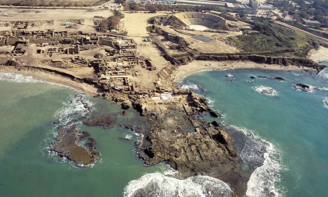
History. Originally a Phoenician city, it really got it’s most significant start under Herod (37BC-4AD) who named it Caesarea in honour of Augustus Caesar and was populated by Romans, Samaritans and Jews. In 66AD, the Jews rebelled, Jerusalem was destroyed and Caesarea became the Roman capital of Judea in 70. During Byzantine times (4th-6th centuries), Caesarea was at its height of prosperity, a centre of Christian scholarship and its harbour the gateway for thousands of Holy Land pilgrims. The Muslims invaded in the 7th century, the Crusaders in 1101 and Saladdin in 1187 conquered it and destroyed its wall. The present fortifications were built in 1251 by the French king Louis IX. The Marmuliks conquered it in 1265 and the city was abandoned until the 19th century when the Ottomans settled Bosnian Muslim refugees here.
A visit to the Caesarea National Park starts off with a 10-minute movie dramatizing the history of the city. At the Crusader city, you can see the remains of the citadel and harbour. Beyond the walls to the north stretch the beachfront remains of an impressive Roman aqueduct. A hippodrome lies to the south, and beyond that, a reconstructed Roman amphitheatre, which serves as a modern-day concert venue. The site makes for a reasonable wander.
Caesarea is 55kms north of Tel Aviv and 40kms south of Haifa. Getting there is a pain on public transport. One method is to take any bus to Hadera then switch to bus 76. A modern, gated Caesarea of walled mansions has developed outside the archaeological area.
I caught bus #41 to the Central Bus Station and then the train from Haganna Station to Caesarea. Outside the train station, I met two young Swiss women working for 3 months as volunteers at a convent/hotel on the Via Dolorosa inside the Old City of Jerusalem. They were on a day trip to see Caesarea. They felt precisely like me about Israeli Jews and Palestinians.
At the train station we caught bus #80 to the Old City or ruins of Caesarea. It took 30 minutes to drive the 5kms – a circuitous route all over the town: part was through a very posh golf resort with very posh houses, most shuttered. We didn’t pick or let off any passengers; I doubt that these people ever take public transport, but their maids, nannies and gardeners do. Also on the bus were three Jews from New York who live in Jerusalem. They were born here, migrated to the US for 35+ years and have returned to live in Israel. None of them liked Israelis either. “They have such bad manners”.
I saw everything in the site taking about 75 minutes. Compared to some of the spectacular Roman sites I have seen this trip – Dougga, Bella Regia, and Jem in Tunisia, Belbak and Tyre in Lebanon and Jerash in Jordan, this is a poor cousin. It is not really worth the trip unless you have the time and desire to navigate the ponderous public transport to get here. I also had my National Park pass so saved the 38S admission fee.
Sidna ‘Ali Mosque is a mosque located in the depopulated village of Al-Haram on the beach in the northern part of Herzliya. It serves as both a mosque and a religious school. The existing building has no parts from before the 15th century.
Herzliya is an affluent city in northern Tel Aviv District known for its robust start-up and entrepreneurial culture. In 2017 it had a population of 93,989, area of 21.6 square kilometres (8.3 sq mi). At its western municipal boundaries is Herzliya Pituah, one of Israel’s most affluent neighbourhoods and home to numerous embassies, company headquarters, as well as prominent Israeli business people.
Sidna Ali Mosque
Herzliya Museum of Contemporary Art
Holon: Design Museum, Israeli Cartoon Museum, Israeli Children’s Museum
TEL AVIV (pop 410,000)
Nicknamed ‘the Bubble’, Tel Aviv (or TLV) is a city of outdoor cafes, boutiques, bistros, leafy boulevards and long sandy beaches – and a favourite with Europeans looking for some year-round sun. All over the city, classic Bauhaus buildings are getting a well-needed facelift, while nearby skyscrapers keep being built.
Tel Aviv is very easy to get around, as its bustling central area focuses on five parallel north–south streets that follow 6km of seafront.
Tel Aviv has a number of superb museums and neighbourhoods worth a wander. Most are within walking distance of the city centre.
Bauhaus Heritage. Tel Aviv has more sleek, clean-lined Bauhaus (International Style) buildings than any other city in the world – why it was declared a Unesco World Heritage Site in 2003. The ideas and ideals of Bauhaus were brought from Germany to Palestine by Jewish architects fleeing Nazi persecution. Tel Aviv’s White City heritage is easy to spot, even through the modifications and dilapidation of the past 70 years. Look for structures characterised by horizontal lines, curved corners (eg balconies), ‘thermometer stairwells’ (stairwells with a row of vertical windows to provide light), and a complete absence of ornamentation.
Carmel Market.
Tel Aviv Museum of Art. Temporary exhibitions of Israeli art and a great permanent collection of Impressionist and post-Impressionist art.
Neve Tzedek. Founded in 1887, Jaffa’s first Jewish suburb has old houses (the most expensive real estate in town, boutiques, wine bars and restaurants.
Northern Tel Aviv. The home to Tel Aviv University and Beit Hatefutsoth, a museum that tells the story of Jewish exile and global diaspora.
Beaches. In warm weather, Tel Avivians flock to the beach, a long golden stretch of sand divided into sections. There are family, religious, gay, party and chill-out beaches. Alma Beach is in Jaffa.
Transportation. During Shabbat, sheruts provide the only public transport. Buses go all over the country.
Train. There are 3 train stations, from north to south: Tel Aviv University, tel Aviv Merkaz, HaShalom and HaHaganna.
To/From the Airport. Ben Gurion Airport is 21kms SE of central Tel Aviv. From 3:30am to 11pm, it is served by at least two trains per hour (14.5S). Taxis cost 130S during the day and 150 at night.
Bicycle. The best way to get around Tel Aviv and Jaffa because of the more than 100kms of dedicated bike paths with rental bikes for 14S per day at over 75 docking stations.
On my second last day in Israel, I took one of the rental bikes all the way to the far north of Tel Aviv and then back on the beach. Rothschild Blvd has the greatest concentration of Bauhaus architecture. It was Shabbat and unbelievably busy. All the restaurants were full, stores busy, beaches crowded, surf breaks full of surfers, people playing beach volleyball, and bicycles.
Museums: Ramat Gan: Ramat Gan Museum of Israeli Art, Beit Hatfutsot, Eretz Israel Museum, Israel Defense Forces History Museum, Rubin Museum
Synagogues: Cymbalista Synagogue, Great Synagogue, Hechal Yehuda Synagogue, O’hel Mo’ed Synagogue
Shopping: Carmel Market, Nachalat Binyamin Arts and Crafts Fair, Dizengoff Center Mall
Architecture:

2 Trumpeldor Street building
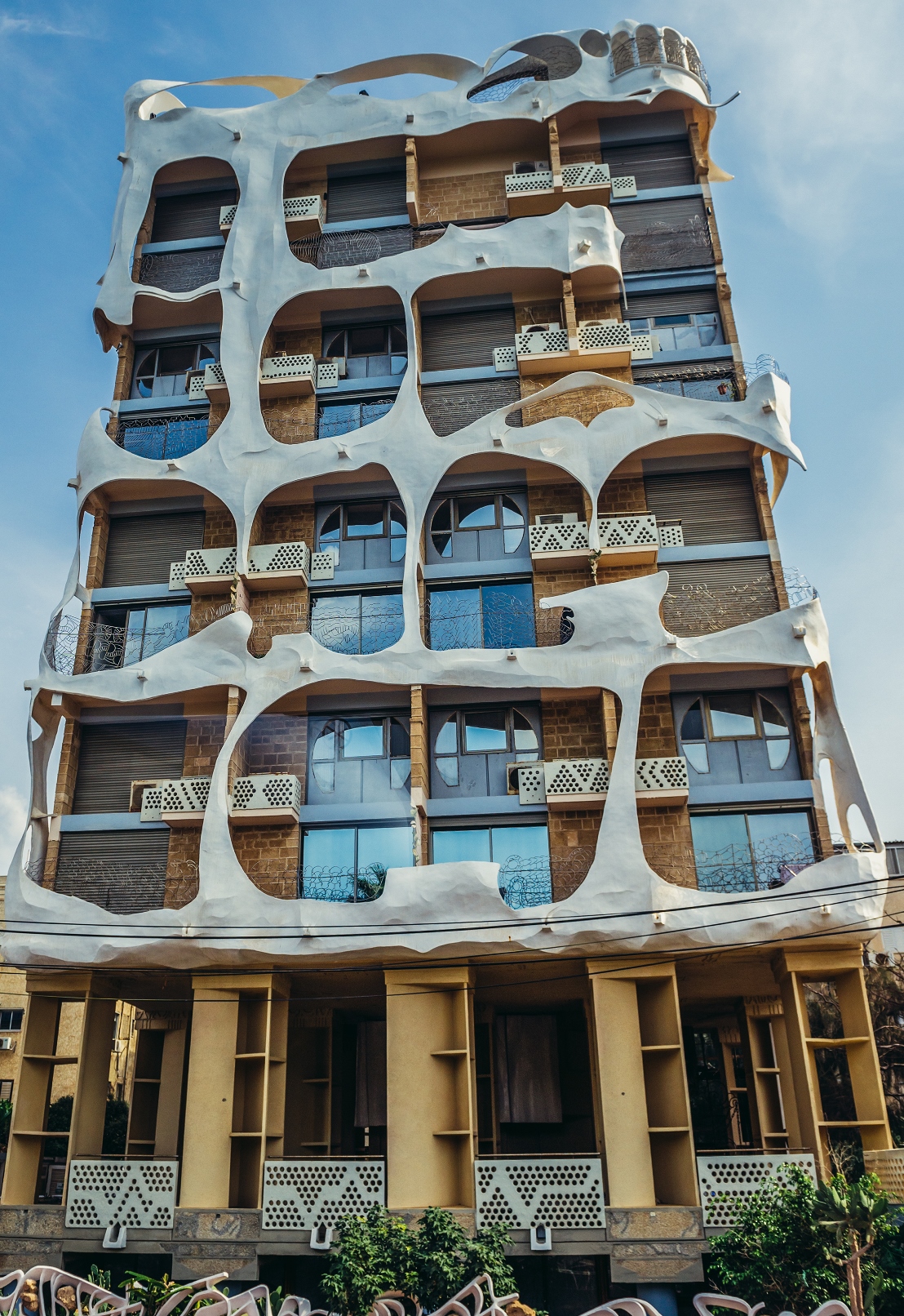
Crazy House
OTHER SITES IN TEL AVIV
St. Peter’s Church.
Mishmar HaShiv’a Windmill
Skate Park Galit
Tzavta (30 Ibn Givrol St) This club/theatre specializes in Israeli music, both folk and popular, as well as theater productions.
Reading Light (Tel Kudadi Light, Hayarkon Light or Tel Aviv Light), is an inactive lighthouse on the north side of the Yarkon River estuary. The lighthouse played a role in several Israel films, such as Late Summer Blues, and appeared on an Israeli stamp issued 26 November 2009.
Petah Tikva is a city 10.6 km east of Tel Aviv founded in 1878 by Orthodox Jews of the Old Yishuv with the financial help of Baron Edmond de Rothschild. In 2017 the city had a population of 240,357. Petah Tikva Zoo is for little kids with lots of birds, monkeys, sheep, deer etc.
RAMAT GAN is located east of Tel Aviv. It is home to one of the world’s major diamond exchanges, and many high-tech industries. It started in 1921 as a moshava, a communal farming settlement, and in 2017 it had a population of 156,277.
Zoological Center Tel Aviv-Ramat Gan (Safari Ramat Gan) is the largest collection of wildlife in human care in the Middle East. The 250-acre site consists of both a drive-through African safari area and a modern outdoor zoo. It is the home of 83 mammals, 92 birds and 23 reptiles. The animals are seen in open air enclosures amid subtropical gardens.
Ramat Gan Museum of Israeli Art
JAFFA (pop 46,000)
History. It is said that after Noah and all those animals survived the Flood, one of his sons, Japheth, headed for the coast and founded a city that he named Jaffa (Yafo in Hebrew) after himself. During Solomon’s time, the city came to prominence as a port and, according to the Bible, it was from here that Jonah set sail to his encounter with the whale. A group of rocks just offshore is said to be where Andromeda, one of Greek mythology’s most beautiful princesses, was saved by Perseus.
For thousands of years, while Tel Aviv was nothing more than a collection of sand dunes, Jaffa was one of the great cities of the Mediterranean. The small port doesn’t get much seafaring traffic these days, but its hangars are being transformed into cafes, shops and art galleries. The town itself, whose residents are a mixture of Jews, Muslims and Christians.
Old City. Centred on Kikar Kedumim, there is St Peter’s Church and the excavated remains from the Hellenistic and Roman eras. To the east is Jaffa’s highest point, Hapisgah Gardens with nice views up the coast to Tel Aviv.
I went on the Free Tour given by a Canadian woman from Alberta (my home province), the same age as me and even the same name, Ronnie! We saw most of the tourist areas of Jaffa, none of which is more than 2-300 years old, even though it is all built on old foundations.
Hassan Bek Mosque
Jaffa Light.
Nalaga’at Center is a nonprofit organization established in 2002, the first theatre company in the world whose performers are all deaf-blind (dual disability). The association established a unique cultural centre at the Laventbondet House, located at Jaffa Port. The centre is a stage for arts and culture.
SOUTH OF JAFFA
HOLON is a city founded in 1935 on the sand dunes 6kms south of Tel Aviv. In 2017 it had a population of 192,624. Holon has the second-largest industrial zone in Israel, after Haifa. The image of Holon as a working-class bedroom community has changed and have rebranded as a child-friendly city, offering family attractions such as the Yamit Water Park, Design Museum, Israeli Children’s Museum and the Israel Museum of Caricature and Comics.
The first documented urban settlement at Ashdod dates to the Canaanite culture of the 17th century BCE, making the city one of the oldest in the world. Ashdod is mentioned 13 times in the Bible. During its pre-1956 history the city was settled by Philistines, Israelites, Greek colonists coming in the wake of Alexander’s conquests, Romans and Byzantines, Arabs, Crusaders, and Ottoman Turks.
Modern Ashdod was established as a planned city in 1956 on the sand hills near the site of the ancient town, Ashdod today is home to the largest Georgian Jewish, Karaite Jewish and Moroccan Jewish community in Israel.
Ashdod Museum of Art,
Performing Arts Center
ASHEKELON (Ascalon) is a coastal city 50kms south of Tel Aviv, and 13kms north of the border with the Gaza Strip. The ancient seaport of Ashkelon dates back to the Neolithic Age. In the course of its history, it has been ruled by the Ancient Egyptians, the Canaanites, the Philistines, the Assyrians, the Babylonians, the Greeks, the Phoenicians, the Hasmoneans, the Romans, the Persians, the Arabs and the Crusaders, until it was destroyed by the Mamluks in 1270.
In 2017 the population of Ashkelon was 137,945.
Marina Breakwater Light
On my last night in Tel Aviv and Israel, I went out for dinner with a bunch of people including 3 working for EAPPI – the Ecumenical Accompaniment Program of Palestine and Israel – funded by the churches of many countries, it sends 30 volunteers at any one time into Palestine for 3-month stints to observe the abuses of Israelis towards Palestinians. They photograph, record and write down their observations, forward everything to the UN and when they go home, talk to their politicians about their experience. They confirmed everything that I have read about and more. One got into a discussion with an Israeli and systematically destroyed all her myths fed to her by the Israeli propaganda machine. She was a lovely, bright young woman, a true polyglot, but I have never seen her so quiet.
For example, Gaza: 15,000 settlers moved in illegally (everything Israel does is illegal by international law) and nothing happened until Hamas kicked them out. It is not hard to understand why Hamas won the next election.
On March 7, I flew on Aeroflot via Moscow to Shanghai. After a quick metro trip across town from Shanghai Pudong Airport to Shanghai Hongqiao Airport, I took the high speed train 3 hrs and 47 minutes south to Shenfang, got a little red tuk-tuk and arrived at Anna’s.